
Grand Canyon of the Tuolumne
Encyclopedia
Valley
In geology, a valley or dale is a depression with predominant extent in one direction. A very deep river valley may be called a canyon or gorge.The terms U-shaped and V-shaped are descriptive terms of geography to characterize the form of valleys...
of the Tuolumne River
Tuolumne River
The Tuolumne River is a California river that flows nearly from the central Sierra Nevada to the San Joaquin River in the Central Valley...
in Yosemite National Park
Yosemite National Park
Yosemite National Park is a United States National Park spanning eastern portions of Tuolumne, Mariposa and Madera counties in east central California, United States. The park covers an area of and reaches across the western slopes of the Sierra Nevada mountain chain...
, USA
United States
The United States of America is a federal constitutional republic comprising fifty states and a federal district...
. As defined by the United States Geological Survey
United States Geological Survey
The United States Geological Survey is a scientific agency of the United States government. The scientists of the USGS study the landscape of the United States, its natural resources, and the natural hazards that threaten it. The organization has four major science disciplines, concerning biology,...
, it begins immediately below Tuolumne Meadows
Tuolumne Meadows
Tuolumne Meadows is a gentle, dome-studded sub-alpine meadowy section of the Tuolumne River, in the eastern section of Yosemite National Park. Its approximate location is . Its approximate elevation is 8619 feet .-Natural History:...
and ends immediately above Hetch Hetchy Valley
Hetch Hetchy Valley
Hetch Hetchy Valley is a glacial valley in Yosemite National Park in California. It is currently completely flooded by O'Shaughnessy Dam, forming the Hetch Hetchy Reservoir. The Tuolumne River fills the reservoir. Upstream from the valley lies the Grand Canyon of the Tuolumne. The reservoir...
.
The Tuolumne River runs as a somewhat wavy line from east to west. It originates in the high-altitude flatlands of Tuolumne Meadows, just west of the Sierra Nevada's main divide. As it runs west, though, its course deepens markedly as it drops over the first of a string of many waterfalls.
Glen Aulin
Glen Aulin
Glen Aulin is a segment of the Tuolumne River valley, upriver from the Grand Canyon of the Tuolumne, approximately long. It is located at , at an elevation of approximately .Glen Aulin is home to the Glen Aulin High Sierra Camp....
(Gaelic: beautiful valley), one of several specifically named locations along the canyon, lies immediately below the confluence of Cold Canyon, Conness Creek, and the Tuolumne River. Here, the valley walls pull away from each other and become steeper. The riverbed is quite level again; the water meanders and forms deep pools.
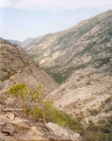
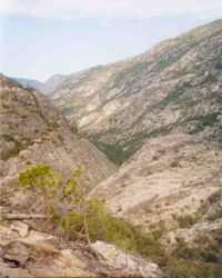
After the waterfall that marks the end of Glen Aulin, the canyon becomes deeper again, and roughly “V”-shaped in cross-section. The walls are not as steep and bare as those of Yosemite Valley
Yosemite Valley
Yosemite Valley is a glacial valley in Yosemite National Park in the western Sierra Nevada mountains of California, carved out by the Merced River. The valley is about long and up to a mile deep, surrounded by high granite summits such as Half Dome and El Capitan, and densely forested with pines...
. The flora of the valley bottom is a haphazard melange of chaparral
Chaparral
Chaparral is a shrubland or heathland plant community found primarily in the U.S. state of California and in the northern portion of the Baja California peninsula, Mexico...
, manzanita
Manzanita
Manzanita is a common name for many species of the genus Arctostaphylos. They are evergreen shrubs or small trees present in the chaparral biome of western North America, where they occur from southern British Columbia, Washington to California, Arizona and New Mexico in the United States, and...
scrub and oak
Oak
An oak is a tree or shrub in the genus Quercus , of which about 600 species exist. "Oak" may also appear in the names of species in related genera, notably Lithocarpus...
woodland characteristic of the foothills and lowlands with a coniferous forest reminiscent of (but different from) that found above the canyon rim. This vegetation clings and clambers up every ledge of the valley walls to the top, giving it a lusher appearance than Yosemite Valley, though this area in fact experiences a drier climate.
Perhaps the greatest of these is 800 feet (243.8 m) Waterwheel Falls
Waterwheel Falls
Waterwheel Falls is a waterfall in the Sierra Nevada of California, located at in Yosemite National Park. It is the largest of the many waterfalls of the Tuolumne River. Its upper part contains a series of small ledges, each of which creates a small plume as the water is deflected away from the...
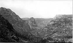
, named for a dramatic circular plume of water that appears when the river and the winds run high. A few kilometres below Glen Aulin, the walls of the lower canyon pinch together to form a narrow chasm of less than a kilometre in length, the Muir Gorge. A short way below the Muir Gorge, the Grand Canyon widens again, much as it does at Glen Aulin, though here it is deeper. This broad plain bears the name of “Pate Valley.” Some six km below here, Hetch Hetchy Reservoir (created by O’Shaughnessy Dam
O'Shaughnessy Dam
The O'Shaughnessy Dam is a curved gravity dam on the Tuolumne River in the Hetch Hetchy Valley of California's Sierra Nevada. The dam is located in Yosemite National Park, and creates the Hetch Hetchy Reservoir. It is named for former San Francisco chief engineer and the original chief engineer of...
) claims the Tuolumne River.
A trail runs along the Tuolumne River from its headwaters to below Pate Valley (though it leaves the valley floor for some time to avoid the impassable Muir Gorge). It is diligently built, but due to the nature of the terrain it is often rocky, steep and generally difficult. The walking distance from the Tioga Road to the High Sierra camp
Glen Aulin High Sierra Camp
Glen Aulin High Sierra Camp is an established campground—one of six High Sierra Camps—located in Glen Aulin next to the Tuolumne River in Yosemite National Park in California, in the Sierra Nevada. The camp is located along the Tuolumne River at an elevation of approximately...
at Glen Aulin is roughly 10 kilometres (6.2 mi) . White Wolf campground, southeast of the reservoir, is within day-hiking distance of the canyon rim, but the return trip from the very bottom is long and toilsome. Between the eastern tip of the reservoir and the point where the trail begins the climb to White Wolf, the valley is a trackless wilderness.