
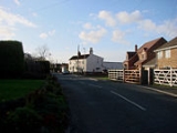
Gowdall
Encyclopedia
Gowdall is a village and civil parish in the East Riding of Yorkshire
, England
. It is situated approximately 1 miles (1.6 km) west of the town of Snaith
.
It lies a mile to the north of the M62 motorway
and A645 road and just south of the River Aire
.
 According to the 2001 UK census
, Gowdall parish had a population of 318.
The parish was part of the Goole Rural District
in the West Riding of Yorkshire
from 1894 to 1974, then in Boothferry district of Humberside
until 1996.
In the year 2000 it was severely flooded, and made national news.
Each October, Gowdall residents host a 'Scarecrow and Pumpkin Festival'.
but was recorded as Goldale sometime in the 12th century.
East Riding of Yorkshire
The East Riding of Yorkshire, or simply East Yorkshire, is a local government district with unitary authority status, and a ceremonial county of England. For ceremonial purposes the county also includes the city of Kingston upon Hull, which is a separate unitary authority...
, England
England
England is a country that is part of the United Kingdom. It shares land borders with Scotland to the north and Wales to the west; the Irish Sea is to the north west, the Celtic Sea to the south west, with the North Sea to the east and the English Channel to the south separating it from continental...
. It is situated approximately 1 miles (1.6 km) west of the town of Snaith
Snaith
Snaith is a town in the East Riding of Yorkshire local government area of England. It is situated approximately west of Goole on the A1041 road at its junction with the A645 road...
.
It lies a mile to the north of the M62 motorway
M62 motorway
The M62 motorway is a west–east trans-Pennine motorway in Northern England, connecting the cities of Liverpool and Hull via Manchester and Leeds. The road also forms part of the unsigned Euroroutes E20 and E22...
and A645 road and just south of the River Aire
River Aire
The River Aire is a major river in Yorkshire, England of length . Part of the river is canalised, and is known as the Aire and Calder Navigation....
.
United Kingdom Census 2001
A nationwide census, known as Census 2001, was conducted in the United Kingdom on Sunday, 29 April 2001. This was the 20th UK Census and recorded a resident population of 58,789,194....
, Gowdall parish had a population of 318.
The parish was part of the Goole Rural District
Goole Rural District
Goole was a rural district in the West Riding of Yorkshire, England from 1894 to 1974.It was created under the Local Government Act 1894, based on most of the Goole rural sanitary district . The town of Goole itself formed a separate urban district...
in the West Riding of Yorkshire
West Riding of Yorkshire
The West Riding of Yorkshire is one of the three historic subdivisions of Yorkshire, England. From 1889 to 1974 the administrative county, County of York, West Riding , was based closely on the historic boundaries...
from 1894 to 1974, then in Boothferry district of Humberside
Humberside
Humberside was a non-metropolitan and ceremonial county in Northern England from 1 April 1974 until 1 April 1996. It was composed of land from either side of the Humber Estuary, created from portions of the East and West ridings of Yorkshire and parts of Lindsey, Lincolnshire...
until 1996.
In the year 2000 it was severely flooded, and made national news.
Each October, Gowdall residents host a 'Scarecrow and Pumpkin Festival'.
Toponymy
The name "Gowdall" originates from Old English. It translates as "Nook of land where marigolds grow", and is composed of the elements golde ("marigold") and halh ("nook of land"). The village was not mentioned in the Domesday BookDomesday Book
Domesday Book , now held at The National Archives, Kew, Richmond upon Thames in South West London, is the record of the great survey of much of England and parts of Wales completed in 1086...
but was recorded as Goldale sometime in the 12th century.