
Goulburn Valley Freeway
Encyclopedia
The Goulburn Valley Freeway  is currently a 43 kilometre (two-section) freeway located in Victoria, Australia
. The section north beyond the Hume Freeway is part of the Melbourne
to Brisbane
National Highway
(together with Hume Freeway) and is the main link between these two cities as well as a major link between Victoria and inland New South Wales. The freeway roughly follows the course of the Goulburn River
. This freeway has been superseded in sections from the original alignment of Goulburn Valley Highway
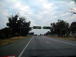
. The entire freeway stretches have a speed limit of 110 km/h.
– 4 lane dual carrageway with tactile road lines, wide shoulders and rest areas
Goulburn Valley Freeway South on Google Maps.
 The Goulburn Valley Highway is defined as a National Highway which means the Australian Government
fully funds improvements to it. It is progressively being upgraded to freeway standard and will ultimately bypass all towns between the junction with the Hume Freeway and the New South Wales border.
The highway will carry an estimated 6,500 vehicles per day, including more than 2,000 commercial vehicles. The freeway will cut travel time and significantly improve the safety of this section of the Goulburn Valley Highway.
It will incorporate four at-grade intersections, frontage access roads, a rest area with full facilities, and installation of wire rope safety barriers.
The Arcadia section runs adjacent to the Calder Woodburn Memorial Avenue of Honour. A Conservation Management Plan has been developed in consultation with Heritage Victoria to ensure that impact on the significant Calder Woodburn Memorial Avenue of Honour is minimised. The plans included measures to enhance and highlight the avenue of trees.
Start Date: June 2006
Completion Date: Open to traffic February 2008, with final completion of all works in April 2008
Cost: $40.55 million funded by the Australian Government
to the east, funding was announced in 2009, and construction commenced in December 2009 with the bypass due to be open in mid 2012.
Costed at $222 million, $177.6 million was contributed by the Australian Government, with the remaining $44.4 million from the State Government. The project is made up of two sections: duplicating the existing highway north of Nagambie for 3.5 km between Kirwans Bridge-Longwood Road and Moss Road, and the 13.5 km bypass road from Mitchellstown Road to Kirwans Bridge-Longwood Road.
http://www.vicroads.vic.gov.au/Home/RoadsAndProjects/RoadProjects/PlanningStudies/Shepparton+Bypass.htm.
Proposed Shepparton Bypass to be funded by Auslink 2 (2009–2014)http://www.doi.vic.gov.au/DOI/DOIElect.nsf/$UNIDS+for+Web+Display/6CA72984A418FC46CA2573A80015C890/$FILE/AusLink2_GoulburnValleyShepp.pdf.
and Yarroweyah
and avoid dangerous bends south of the Murray River
crossing
at Tocumwal
http://www.vicroads.vic.gov.au/Home/RoadsAndProjects/RoadProjects/PlanningStudies/Strathmerton+Deviation.htm.
Proposed Strathmerton Deviation to be funded by Auslink 2 (2009–2014)http://www.doi.vic.gov.au/DOI/DOIElect.nsf/$UNIDS+for+Web+Display/D1D31509C5242C45CA2573A80015CAE8/$FILE/AusLink2_GoulburnValleyStrathmerton.pdf.
is currently a 43 kilometre (two-section) freeway located in Victoria, AustraliaAustralia
Australia , officially the Commonwealth of Australia, is a country in the Southern Hemisphere comprising the mainland of the Australian continent, the island of Tasmania, and numerous smaller islands in the Indian and Pacific Oceans. It is the world's sixth-largest country by total area...
. The section north beyond the Hume Freeway is part of the Melbourne
Melbourne
Melbourne is the capital and most populous city in the state of Victoria, and the second most populous city in Australia. The Melbourne City Centre is the hub of the greater metropolitan area and the Census statistical division—of which "Melbourne" is the common name. As of June 2009, the greater...
to Brisbane
Brisbane
Brisbane is the capital and most populous city in the Australian state of Queensland and the third most populous city in Australia. Brisbane's metropolitan area has a population of over 2 million, and the South East Queensland urban conurbation, centred around Brisbane, encompasses a population of...
National Highway
National Highway (Australia)
thumb|right|150px|The National Highway Shield in NSW, QLD, WA, NT & TAS.The National Highway is a system of roads connecting all the States and Territories of Australia, and is the major network of highways connecting Australia's largest and most important cities.The National Highway was...
(together with Hume Freeway) and is the main link between these two cities as well as a major link between Victoria and inland New South Wales. The freeway roughly follows the course of the Goulburn River
Goulburn River (Victoria)
The Goulburn River is a major inland river in Victoria, Australia.The headwaters of the Goulburn River rise in the western end of the Victoria Alps, near Mount Buller. The Eildon Dam creates Lake Eildon, a major storage of water for irrigation...
. This freeway has been superseded in sections from the original alignment of Goulburn Valley Highway
Goulburn Valley Highway
The Goulburn Valley Highway / is a highway located in Victoria, Australia. The section north beyond the Hume Freeway is part of the Melbourne to Brisbane National Highway and is the main link between these two cities as well as a major link between Victoria and inland New South Wales...
. The entire freeway stretches have a speed limit of 110 km/h.
Current Freeway situation
– 4 lane dual carrageway with tactile road lines, wide shoulders and rest areas
- Between the Hume Freeway and 5 km south of Nagambie
- Between just south of the Wahring Roadhouse and Ross Road, Arcadia (17 km south of Shepparton)
Exits & Intersections
| Goulburn Valley Freeway |
|||
Northbound exits / intersections .svg.png) |
Distance to Brisbane (km) |
Distance to Melbourne (km) |
Southbound exits / intersections |
| End Goulburn Valley Freeway continues as Goulburn Valley Highway Goulburn Valley Highway The Goulburn Valley Highway / is a highway located in Victoria, Australia. The section north beyond the Hume Freeway is part of the Melbourne to Brisbane National Highway and is the main link between these two cities as well as a major link between Victoria and inland New South Wales...  to Shepparton Shepparton, Victoria Shepparton is a city located on the floodplain of the Goulburn River in the north east of Victoria, Australia approximately north-east of Melbourne. It is the fifth largest city in Victoria, Australia. The estimated population of Shepparton's statistical area is 48,926.It began as a sheep station... / Brisbane Brisbane Brisbane is the capital and most populous city in the Australian state of Queensland and the third most populous city in Australia. Brisbane's metropolitan area has a population of over 2 million, and the South East Queensland urban conurbation, centred around Brisbane, encompasses a population of... |
1509 | 173 | Start Goulburn Valley Freeway from Goulburn Valley Highway Goulburn Valley Highway The Goulburn Valley Highway / is a highway located in Victoria, Australia. The section north beyond the Hume Freeway is part of the Melbourne to Brisbane National Highway and is the main link between these two cities as well as a major link between Victoria and inland New South Wales... |
| Ross Road / Karramomus Road |
|||
| Doyles Road |
1511 | 171 | Doyles Road |
| Arcadia Arcadia, Victoria Arcadia is a small town in Victoria, Australia. It is located on Kennedys Road, in the City of Greater Shepparton, south of Shepparton. At the 2006 census, Arcadia had a population of 659.... , Tamleugh West Arcadia Road |
1513 | 169 | Tamleugh West, Arcadia Arcadia, Victoria Arcadia is a small town in Victoria, Australia. It is located on Kennedys Road, in the City of Greater Shepparton, south of Shepparton. At the 2006 census, Arcadia had a population of 659.... Arcadia Road |
| Euroa Euroa, Victoria Euroa is a town in the Shire of Strathbogie in North-East Victoria, Australia.At the 2006 census, Euroa had a population of 2,776. The name Euroa comes from an Aboriginal word in the old local dialect meaning "joyful".-History:Major T.L... Arcadia Two Chain Road |
1514 | 168 | Euroa Euroa, Victoria Euroa is a town in the Shire of Strathbogie in North-East Victoria, Australia.At the 2006 census, Euroa had a population of 2,776. The name Euroa comes from an Aboriginal word in the old local dialect meaning "joyful".-History:Major T.L... Arcadia Two Chain Road |
| Zocks Road |
1514.5 | 167.5 | Zocks Road |
| Arcadia Arcadia, Victoria Arcadia is a small town in Victoria, Australia. It is located on Kennedys Road, in the City of Greater Shepparton, south of Shepparton. At the 2006 census, Arcadia had a population of 659.... Noonans Road |
1516 | 166 | Noonans Road |
| Baliffs Road |
1518 | 164 | Baliffs Road |
| Murchison Murchison, Victoria Murchison is a small rural village located on the Goulburn River in Victoria, Australia. Murchison is located 167 kilometres from Melbourne and is just to the west of the Goulburn Valley Highway between Shepparton and Nagambie. The surrounding countryside contains orchards, vineyards and dairy... , Violet Town Violet Town, Victoria Violet Town is a town in Victoria, Australia. It is in the Shire of Strathbogie local government area. It was a coach stop on the Melbourne to Sydney road... Murchison-Violet Town Road  |
1520 | 162 | Violet Town Violet Town, Victoria Violet Town is a town in Victoria, Australia. It is in the Shire of Strathbogie local government area. It was a coach stop on the Melbourne to Sydney road... , Murchison Murchison, Victoria Murchison is a small rural village located on the Goulburn River in Victoria, Australia. Murchison is located 167 kilometres from Melbourne and is just to the west of the Goulburn Valley Highway between Shepparton and Nagambie. The surrounding countryside contains orchards, vineyards and dairy... Murchison-Violet Town Road |
| Douglas Road / Burkes Road |
1524 | 158 | Burkes / Douglas Road |
| Murchison East, Monea Dargalong Road |
1529 | 153 | Monea, Murchison East Dargalong Road |
| SHEPPARTON RAIL LINE | 1532 | 150 | SHEPPARTON RAIL LINE |
| Murchison Murchison, Victoria Murchison is a small rural village located on the Goulburn River in Victoria, Australia. Murchison is located 167 kilometres from Melbourne and is just to the west of the Goulburn Valley Highway between Shepparton and Nagambie. The surrounding countryside contains orchards, vineyards and dairy... , Rushworth Rushworth, Victoria Rushworth is a township in Victoria, Australia. It is located north of Melbourne and, at the 2006 census, had a population of 2066.-History:... , Tatura Tatura, Victoria Tatura is a town 17 km west-south-west of Shepparton in Victoria, Australia located 3 km off the Midland Highway, forming part of the City of Greater Shepparton. At the 2006 census, Tatura had a population of 3,533, however the true figure is believed to be close to 4,400. Attractions... Wahring-Murchison East Road  |
no exit | ||
| Wahring, Euroa Euroa, Victoria Euroa is a town in the Shire of Strathbogie in North-East Victoria, Australia.At the 2006 census, Euroa had a population of 2,776. The name Euroa comes from an Aboriginal word in the old local dialect meaning "joyful".-History:Major T.L... Wahring-Euroa Road |
1535 | 147 | Euroa Euroa, Victoria Euroa is a town in the Shire of Strathbogie in North-East Victoria, Australia.At the 2006 census, Euroa had a population of 2,776. The name Euroa comes from an Aboriginal word in the old local dialect meaning "joyful".-History:Major T.L... , Wahring Wahring-Euroa Road |
| Caltex SERVICE CENTRE Caltex Caltex is a petroleum brand name of Chevron Corporation used in more than 60 countries in the Asia-Pacific region, the Middle East, and southern Africa.-History:... |
|||
| END SINGLE CARRIAGEWAY SECTION | 1536 | 146 | START SINGLE CARRIAGEWAY SECTION Proposed Nagambie Bypass completion 2014 |
| Nagambie Nagambie, Victoria Nagambie is a town in Victoria, Australia, located on the Goulburn Valley Highway, north of Seymour, in the Shire of Strathbogie. At the 2006 census, Nagambie had a population of 1,383.-History:... via highwayGoulburn Valley Highway The Goulburn Valley Highway / is a highway located in Victoria, Australia. The section north beyond the Hume Freeway is part of the Melbourne to Brisbane National Highway and is the main link between these two cities as well as a major link between Victoria and inland New South Wales... |
1545 | 137 | Nagambie Nagambie, Victoria Nagambie is a town in Victoria, Australia, located on the Goulburn Valley Highway, north of Seymour, in the Shire of Strathbogie. At the 2006 census, Nagambie had a population of 1,383.-History:... via highwayGoulburn Valley Highway The Goulburn Valley Highway / is a highway located in Victoria, Australia. The section north beyond the Hume Freeway is part of the Melbourne to Brisbane National Highway and is the main link between these two cities as well as a major link between Victoria and inland New South Wales... |
| START SINGLE CARRIAGEWAY SECTION Proposed Nagambie Bypass completion 2014 |
1551 | 131 | END SINGLE CARRIAGEWAY SECTION |
| Mitchellstown, Monea Mitchellstown Road / Tabilk-Monea Road |
1552 | 130 | Monea, Mitchellstown Tabilk-Monea Road / Mitchellstown Road |
| Avenel Avenel, Victoria Avenel is a small town in Victoria, Australia. It is in the Shire of Strathbogie local government area. At the 2006 census, Avenel had a population of 728, up from 552 in the 2001 Census.-History:... Avenel-Nagambie Road  |
Avenel Avenel, Victoria Avenel is a small town in Victoria, Australia. It is in the Shire of Strathbogie local government area. At the 2006 census, Avenel had a population of 728, up from 552 in the 2001 Census.-History:... Avenel-Nagambie Road |
||
| Avenel Avenel, Victoria Avenel is a small town in Victoria, Australia. It is in the Shire of Strathbogie local government area. At the 2006 census, Avenel had a population of 728, up from 552 in the 2001 Census.-History:... Aerodrome Road |
1558 | 124 | Avenel Avenel, Victoria Avenel is a small town in Victoria, Australia. It is in the Shire of Strathbogie local government area. At the 2006 census, Avenel had a population of 728, up from 552 in the 2001 Census.-History:... Aerodrome Road |
| Mangalore Gerrards Road |
1561 | 121 | Mangalore Gerrards Road |
| Selectors Road / Nalinga Road |
1566 | 116 | Nalinga Road / Selectors Road |
| Start Goulburn Valley Freeway from Hume Freeway  |
1568 | 114 | Seymour Seymour, Victoria Seymour is a township in the Shire of Mitchell in the state of Victoria, Australia and is located north of Melbourne. At the 2006 census, Seymour had a population of 6,063... , Yea Yea, Victoria Yea is a town in Victoria, Australia. It is in the Shire of Murrindindi local government area. Located north-east of Melbourne via the Melba Highway, Yea sits at the junction with the Goulburn Valley Highway, and above sea-level. At the 2006 Census, Yea had a population of 1,052.- History :The... Goulburn Valley Highway Goulburn Valley Highway The Goulburn Valley Highway / is a highway located in Victoria, Australia. The section north beyond the Hume Freeway is part of the Melbourne to Brisbane National Highway and is the main link between these two cities as well as a major link between Victoria and inland New South Wales...  |
| Wodonga Wodonga, Victoria Wodonga is a small city on the Victorian side of the border with New South Wales, north-east of Melbourne, Australia. Adjacent to Wodonga across the border is the New South Wales city of Albury. Wodonga is located wholly within the boundaries of the City of Wodonga LGA... , Sydney Sydney Sydney is the most populous city in Australia and the state capital of New South Wales. Sydney is located on Australia's south-east coast of the Tasman Sea. As of June 2010, the greater metropolitan area had an approximate population of 4.6 million people... Hume Freeway |
|||
| End Goulburn Valley Freeway continues as Hume Freeway to Melbourne Melbourne Melbourne is the capital and most populous city in the state of Victoria, and the second most populous city in Australia. The Melbourne City Centre is the hub of the greater metropolitan area and the Census statistical division—of which "Melbourne" is the common name. As of June 2009, the greater... |
|||
Source
Goulburn Valley Freeway North on Google Maps.Goulburn Valley Freeway South on Google Maps.
Past and future development
Government of Australia
The Commonwealth of Australia is a federal constitutional monarchy under a parliamentary democracy. The Commonwealth of Australia was formed in 1901 as a result of an agreement among six self-governing British colonies, which became the six states...
fully funds improvements to it. It is progressively being upgraded to freeway standard and will ultimately bypass all towns between the junction with the Hume Freeway and the New South Wales border.
Arcadia Duplication
The duplication is a $40.55 million project funded by the Australian Government as part of its Auslink Program. The works involve duplication of 11km of the existing Goulburn Valley Highway between the Murchison East deviation and the proposed Shepparton Bypass, just north of Ross Road.The highway will carry an estimated 6,500 vehicles per day, including more than 2,000 commercial vehicles. The freeway will cut travel time and significantly improve the safety of this section of the Goulburn Valley Highway.
It will incorporate four at-grade intersections, frontage access roads, a rest area with full facilities, and installation of wire rope safety barriers.
The Arcadia section runs adjacent to the Calder Woodburn Memorial Avenue of Honour. A Conservation Management Plan has been developed in consultation with Heritage Victoria to ensure that impact on the significant Calder Woodburn Memorial Avenue of Honour is minimised. The plans included measures to enhance and highlight the avenue of trees.
Start Date: June 2006
Completion Date: Open to traffic February 2008, with final completion of all works in April 2008
Cost: $40.55 million funded by the Australian Government
Nagambie Bypass
Nagambie Bypass, to be funded by Auslink 2 (2009–2014). Bypassing the town of NagambieNagambie, Victoria
Nagambie is a town in Victoria, Australia, located on the Goulburn Valley Highway, north of Seymour, in the Shire of Strathbogie. At the 2006 census, Nagambie had a population of 1,383.-History:...
to the east, funding was announced in 2009, and construction commenced in December 2009 with the bypass due to be open in mid 2012.
Costed at $222 million, $177.6 million was contributed by the Australian Government, with the remaining $44.4 million from the State Government. The project is made up of two sections: duplicating the existing highway north of Nagambie for 3.5 km between Kirwans Bridge-Longwood Road and Moss Road, and the 13.5 km bypass road from Mitchellstown Road to Kirwans Bridge-Longwood Road.
Shepparton Bypass
An alignment for the Shepparton bypass has been decided. The bypass will cross the Goulburn River at Toolamba and travel west of Mooroopna rejoining the existing highway north of CongupnaCongupna, Victoria
Congupna is a town in the Goulburn Valley region of Victoria, Australia. The town is located in the City of Greater Shepparton local government area, north of the state capital, Melbourne and north of the regional centre of Shepparton...
http://www.vicroads.vic.gov.au/Home/RoadsAndProjects/RoadProjects/PlanningStudies/Shepparton+Bypass.htm.
Proposed Shepparton Bypass to be funded by Auslink 2 (2009–2014)http://www.doi.vic.gov.au/DOI/DOIElect.nsf/$UNIDS+for+Web+Display/6CA72984A418FC46CA2573A80015C890/$FILE/AusLink2_GoulburnValleyShepp.pdf.
Strathmerton Deviation
This realignment will bypass the small townships of StrathmertonStrathmerton, Victoria
Strathmerton is a small country town in Victoria, Australia.It is located in the Shire of Moira Local Government Area on the Murray Valley Highway, about west of Cobram and previously known as the most northerly point in Victoria North of Melbourne at the start of the Goulburn Valley Highway...
and Yarroweyah
Yarroweyah, Victoria
Yarroweyah is a town in northern Victoria, Australia. The town is located in the Shire of Moira Local Government Area, north of the state capital, Melbourne and west of Cobram. The town is situated on the intersection of the Goulburn Valley Highway and Murray Valley Highways...
and avoid dangerous bends south of the Murray River
Murray River
The Murray River is Australia's longest river. At in length, the Murray rises in the Australian Alps, draining the western side of Australia's highest mountains and, for most of its length, meanders across Australia's inland plains, forming the border between New South Wales and Victoria as it...
crossing
Murray River crossings
The Murray River in south-eastern Australia has been a significant barrier to land-based travel and trade. This article lists and briefly describes all of the recognised crossing points. Many of these had also developed as river ports for transport of goods along the Murray...
at Tocumwal
Tocumwal, New South Wales
Tocumwal is a town in the southern Riverina region of New South Wales, Australia in the Berrigan Shire Local Government Area, near the Victorian border. The town is situated on the banks of the Murray River, north of the city of Melbourne. The Newell Highway, part of the main road route between...
http://www.vicroads.vic.gov.au/Home/RoadsAndProjects/RoadProjects/PlanningStudies/Strathmerton+Deviation.htm.
Proposed Strathmerton Deviation to be funded by Auslink 2 (2009–2014)http://www.doi.vic.gov.au/DOI/DOIElect.nsf/$UNIDS+for+Web+Display/D1D31509C5242C45CA2573A80015CAE8/$FILE/AusLink2_GoulburnValleyStrathmerton.pdf.
See also
- Freeways in AustraliaFreeways in AustraliaThis is a list of freeways and motorways in Australia, sorted by states and territories and their corresponding routes. This list includes toll roads such as the CityLink freeway system in Melbourne. This list has over 70 entries...
- Freeways in Victoria