
Golddust, Tennessee
Encyclopedia
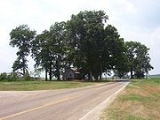
Golddust is a rural unincorporated community in Lauderdale County, Tennessee
, United States
, located on the banks of the Mississippi River
. Golddust is one of the earliest settlements in Lauderdale County.
In 1864, the Battle of Fort Pillow
was fought about 3 mi (4,8 km) south of Golddust.
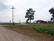
Island No. 30 of the Mississippi River is located ca. 2.5 mi (4 km) west of Golddust. The landscape of the area is dominated by the Mississippi River valley
, flood plains and cotton
fields. Most dwellings in the area are built on stilts to withstand floods.
Golddust is situated on the southeastern edge of the New Madrid Seismic Zone
, an area with a high earthquake
risk.
built extensive fortifications south of Golddust and named the site for General Gideon J. Pillow. Because of its strategic location, the fort was taken by the Union Army
in 1864.
Fort Pillow State Park
is located ca. 3 mi (4,8 km) south of Golddust.
 Agriculture
is the dominant source of income in the area surrounding Golddust, especially the cultivation of cotton
.
After the abolition of slavery, sharecropping
was the primary means of income for low income families in the area. Mostly for the cultivation
of cotton
, land would be used by sharecroppers in return for a share of the crop to the landowner.
Modern machines such as the cotton picker
have made the manual cultivation
obsolete over time as they took over the work from the hand laborers
.
As of 2007, there are no industries in Golddust. Dwellings are scattered, some of them abandoned, and the borders of the community are unmarked.
starts at the Mississippi River in Golddust, heading east through Ripley
(Lauderdale County), Nutbush
and Brownsville
(both in Haywood County) to Interstate 40
.http://www.tdot.state.tn.us/Maps/county/co49.pdf Lauderdale County, TN Highway Map
Tennessee
Tennessee is a U.S. state located in the Southeastern United States. It has a population of 6,346,105, making it the nation's 17th-largest state by population, and covers , making it the 36th-largest by total land area...
, United States
United States
The United States of America is a federal constitutional republic comprising fifty states and a federal district...
, located on the banks of the Mississippi River
Mississippi River
The Mississippi River is the largest river system in North America. Flowing entirely in the United States, this river rises in western Minnesota and meanders slowly southwards for to the Mississippi River Delta at the Gulf of Mexico. With its many tributaries, the Mississippi's watershed drains...
. Golddust is one of the earliest settlements in Lauderdale County.
In 1864, the Battle of Fort Pillow
Battle of Fort Pillow
The Battle of Fort Pillow, also known as the Fort Pillow Massacre, was fought on April 12, 1864, at Fort Pillow on the Mississippi River in Henning, Tennessee, during the American Civil War. The battle ended with a massacre of surrendered Federal black troops by soldiers under the command of...
was fought about 3 mi (4,8 km) south of Golddust.
Geography
Golddust is located at 35.72540 North, 89.85870 West. The elevation above sea level is 248 ft (75.6 m).Island No. 30 of the Mississippi River is located ca. 2.5 mi (4 km) west of Golddust. The landscape of the area is dominated by the Mississippi River valley
Valley
In geology, a valley or dale is a depression with predominant extent in one direction. A very deep river valley may be called a canyon or gorge.The terms U-shaped and V-shaped are descriptive terms of geography to characterize the form of valleys...
, flood plains and cotton
Cotton
Cotton is a soft, fluffy staple fiber that grows in a boll, or protective capsule, around the seeds of cotton plants of the genus Gossypium. The fiber is almost pure cellulose. The botanical purpose of cotton fiber is to aid in seed dispersal....
fields. Most dwellings in the area are built on stilts to withstand floods.
Golddust is situated on the southeastern edge of the New Madrid Seismic Zone
New Madrid Seismic Zone
The New Madrid Seismic Zone , sometimes called the New Madrid Fault Line, is a major seismic zone and a prolific source of intraplate earthquakes in the southern and midwestern United States, stretching to the southwest from New Madrid, Missouri.The New Madrid fault system was responsible for the...
, an area with a high earthquake
Earthquake
An earthquake is the result of a sudden release of energy in the Earth's crust that creates seismic waves. The seismicity, seismism or seismic activity of an area refers to the frequency, type and size of earthquakes experienced over a period of time...
risk.
Establishment 1820s
Golddust was founded in the 1820s. It is one of the earliest settlements in Lauderdale County.Battle of Fort Pillow 1864
In 1861, the Confederate States ArmyConfederate States Army
The Confederate States Army was the army of the Confederate States of America while the Confederacy existed during the American Civil War. On February 8, 1861, delegates from the seven Deep South states which had already declared their secession from the United States of America adopted the...
built extensive fortifications south of Golddust and named the site for General Gideon J. Pillow. Because of its strategic location, the fort was taken by the Union Army
Union Army
The Union Army was the land force that fought for the Union during the American Civil War. It was also known as the Federal Army, the U.S. Army, the Northern Army and the National Army...
in 1864.
Fort Pillow State Park
Fort Pillow State Park
Fort Pillow State Park is a state park in western Tennessee that preserves the American Civil War site of the Battle of Fort Pillow. The 1,642 acre Fort Pillow, located in Lauderdale County on the Chickasaw Bluffs overlooking the Mississippi River, is rich in both historic and archaeological...
is located ca. 3 mi (4,8 km) south of Golddust.
Economy
Agriculture
Agriculture is the cultivation of animals, plants, fungi and other life forms for food, fiber, and other products used to sustain life. Agriculture was the key implement in the rise of sedentary human civilization, whereby farming of domesticated species created food surpluses that nurtured the...
is the dominant source of income in the area surrounding Golddust, especially the cultivation of cotton
Cotton
Cotton is a soft, fluffy staple fiber that grows in a boll, or protective capsule, around the seeds of cotton plants of the genus Gossypium. The fiber is almost pure cellulose. The botanical purpose of cotton fiber is to aid in seed dispersal....
.
After the abolition of slavery, sharecropping
Sharecropping
Sharecropping is a system of agriculture in which a landowner allows a tenant to use the land in return for a share of the crop produced on the land . This should not be confused with a crop fixed rent contract, in which a landowner allows a tenant to use the land in return for a fixed amount of...
was the primary means of income for low income families in the area. Mostly for the cultivation
Tillage
Tillage is the agricultural preparation of the soil by mechanical agitation of various types, such as digging, stirring, and overturning. Examples of human-powered tilling methods using hand tools include shovelling, picking, mattock work, hoeing, and raking...
of cotton
Cotton
Cotton is a soft, fluffy staple fiber that grows in a boll, or protective capsule, around the seeds of cotton plants of the genus Gossypium. The fiber is almost pure cellulose. The botanical purpose of cotton fiber is to aid in seed dispersal....
, land would be used by sharecroppers in return for a share of the crop to the landowner.
Modern machines such as the cotton picker
Cotton picker
The mechanical cotton picker is a machine that automates cotton harvesting in a way that reduces harvest time and maximizes efficiency.-History:...
have made the manual cultivation
Tillage
Tillage is the agricultural preparation of the soil by mechanical agitation of various types, such as digging, stirring, and overturning. Examples of human-powered tilling methods using hand tools include shovelling, picking, mattock work, hoeing, and raking...
obsolete over time as they took over the work from the hand laborers
Manual labour
Manual labour , manual or manual work is physical work done by people, most especially in contrast to that done by machines, and also to that done by working animals...
.
As of 2007, there are no industries in Golddust. Dwellings are scattered, some of them abandoned, and the borders of the community are unmarked.
Infrastructure
Tennessee State Route 19Tennessee State Route 19
State Route 19 or the Tina Turner Highway is a road in Haywood and Lauderdale Counties, Tennessee, United States.http://www.tdot.state.tn.us/Maps/county/co49.pdf Lauderdale County, TN Highway Maphttp://www.tdot.state.tn.us/Maps/county/co38.pdf Haywood County, TN Highway Map State Route 19 is 42.81...
starts at the Mississippi River in Golddust, heading east through Ripley
Ripley, Tennessee
Ripley is a city in Lauderdale County, Tennessee, United States. The population was 7,844 at the 2000 census. It is the county seat of Lauderdale County...
(Lauderdale County), Nutbush
Nutbush, Tennessee
Nutbush is an unincorporated rural community in Haywood County, Tennessee, United States, in the western part of the state.Established in the early 19th century, Nutbush is home to two early American churches founded by white settlers, Woodlawn Baptist Church and Trinity United Methodist Church...
and Brownsville
Brownsville, Tennessee
Brownsville is a city in Haywood County, Tennessee, United States. It is the county seat of Haywood County. The city is named after Jacob Jennings Brown, an officer who served during The War of 1812.-Geography:...
(both in Haywood County) to Interstate 40
Interstate 40
Interstate 40 is the third-longest major east–west Interstate Highway in the United States, after I-90 and I-80. Its western end is at Interstate 15 in Barstow, California; its eastern end is at a concurrency of U.S. Route 117 and North Carolina Highway 132 in Wilmington, North Carolina...
.http://www.tdot.state.tn.us/Maps/county/co49.pdf Lauderdale County, TN Highway Map