
Gething Formation
Encyclopedia
Gething Formation is a stratigraphical
unit of Lower Cretaceous age
in the Western Canadian Sedimentary Basin
.
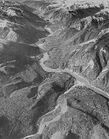
It was first described in the Peace River
Canyon by F.H. McLearn in 1923. The canyon was partly inundated in 1968 by the Williston Lake
after the construction of the W. A. C. Bennett Dam
. The Formation is named for Gething Creek, a right tributary of the Peace River east of Hudson's Hope
and the nearby Gething Mountain.
, conglomeratic sandstone
, sandstone
, coal
and marine siltstone
and shale
.
Dinosaur
tracks can be found in the formation.
and Smoky River
areas of western Alberta
. In the Peace River Country
, it reaches a thickness of 550 metres (1,804.5 ft), while in the Smoky River area it is 75 metres (246.1 ft) thick. It is also present in the Canadian Rockies
foothills, where it can reach 1000 metres (3,280.8 ft) near Carbon Creek.
and is disconformably
overlain by Fort St. John Group
or the Bluesky Formation
. It can be correlated with the Gladstone Formation in the southern foothills, and is equivalent with the tar sand bearing McMurray Formation
mined in the Athabasca Oil Sands
.
Stratigraphy
Stratigraphy, a branch of geology, studies rock layers and layering . It is primarily used in the study of sedimentary and layered volcanic rocks....
unit of Lower Cretaceous age
Geochronology
Geochronology is the science of determining the age of rocks, fossils, and sediments, within a certain degree of uncertainty inherent to the method used. A variety of dating methods are used by geologists to achieve this, and schemes of classification and terminology have been proposed...
in the Western Canadian Sedimentary Basin
Western Canadian Sedimentary Basin
The Western Canadian Sedimentary Basin is a vast sedimentary basin underlying of Western Canada including southwestern Manitoba, southern Saskatchewan, Alberta, northeastern British Columbia and the southwest corner of the Northwest Territories. It consists of a massive wedge of sedimentary rock...
.
It was first described in the Peace River
Peace River (Canada)
The Peace River is a river in Canada that originates in the Rocky Mountains of northern British Columbia and flows to the northeast through northern Alberta. The Peace River flows into the Slave River, a tributary of the Mackenzie River. The Mackenzie is the 12th longest river in the world,...
Canyon by F.H. McLearn in 1923. The canyon was partly inundated in 1968 by the Williston Lake
Williston Lake
Williston Lake is a reservoir created by the W. A. C. Bennett Dam and is located in the Northern Interior of British Columbia, Canada.-Geography:...
after the construction of the W. A. C. Bennett Dam
W. A. C. Bennett Dam
The W. A. C. Bennett Dam is a large hydroelectric earthfill dam on the Peace River in northern British Columbia, Canada. The dam, located 19 kilometres west of Hudson's Hope, and 85 kilometres northwest of Chetwynd, is named after the late former premier W. A. C. Bennett, and came on-line in 1968...
. The Formation is named for Gething Creek, a right tributary of the Peace River east of Hudson's Hope
Hudson's Hope, British Columbia
Hudson's Hope is a district municipality in northeastern British Columbia, Canada, in the Peace River Regional District. It covers an area of with a population of 1,157 people. Having been first settled in 1805, it is the third oldest community in the province, although it was not incorporated...
and the nearby Gething Mountain.
Lithology
The formation is composed of conglomerateConglomerate (geology)
A conglomerate is a rock consisting of individual clasts within a finer-grained matrix that have become cemented together. Conglomerates are sedimentary rocks consisting of rounded fragments and are thus differentiated from breccias, which consist of angular clasts...
, conglomeratic sandstone
Sandstone
Sandstone is a sedimentary rock composed mainly of sand-sized minerals or rock grains.Most sandstone is composed of quartz and/or feldspar because these are the most common minerals in the Earth's crust. Like sand, sandstone may be any colour, but the most common colours are tan, brown, yellow,...
, sandstone
Sandstone
Sandstone is a sedimentary rock composed mainly of sand-sized minerals or rock grains.Most sandstone is composed of quartz and/or feldspar because these are the most common minerals in the Earth's crust. Like sand, sandstone may be any colour, but the most common colours are tan, brown, yellow,...
, coal
Coal
Coal is a combustible black or brownish-black sedimentary rock usually occurring in rock strata in layers or veins called coal beds or coal seams. The harder forms, such as anthracite coal, can be regarded as metamorphic rock because of later exposure to elevated temperature and pressure...
and marine siltstone
Siltstone
Siltstone is a sedimentary rock which has a grain size in the silt range, finer than sandstone and coarser than claystones.- Description :As its name implies, it is primarily composed of silt sized particles, defined as grains 1/16 - 1/256 mm or 4 to 8 on the Krumbein phi scale...
and shale
Shale
Shale is a fine-grained, clastic sedimentary rock composed of mud that is a mix of flakes of clay minerals and tiny fragments of other minerals, especially quartz and calcite. The ratio of clay to other minerals is variable. Shale is characterized by breaks along thin laminae or parallel layering...
.
Dinosaur
Dinosaur
Dinosaurs are a diverse group of animals of the clade and superorder Dinosauria. They were the dominant terrestrial vertebrates for over 160 million years, from the late Triassic period until the end of the Cretaceous , when the Cretaceous–Paleogene extinction event led to the extinction of...
tracks can be found in the formation.
Distribution
The Gething Formation is found in the Peace RiverPeace River (Canada)
The Peace River is a river in Canada that originates in the Rocky Mountains of northern British Columbia and flows to the northeast through northern Alberta. The Peace River flows into the Slave River, a tributary of the Mackenzie River. The Mackenzie is the 12th longest river in the world,...
and Smoky River
Smoky River
Smoky River is a river in western Alberta, Canada. It is a major tributary of the Peace River. The descriptive name refers to the presence of "smouldering beds of coal in the riverbank" noted by the Cree Indians....
areas of western Alberta
Alberta
Alberta is a province of Canada. It had an estimated population of 3.7 million in 2010 making it the most populous of Canada's three prairie provinces...
. In the Peace River Country
Peace River Country
The Peace River Country is an aspen parkland region around the Peace River in Canada. It spans from northwestern Alberta to the Rocky Mountains in northeastern British Columbia, where the region is also referred to as the Peace River Block.- Geography :The Peace River Country includes the...
, it reaches a thickness of 550 metres (1,804.5 ft), while in the Smoky River area it is 75 metres (246.1 ft) thick. It is also present in the Canadian Rockies
Canadian Rockies
The Canadian Rockies comprise the Canadian segment of the North American Rocky Mountains range. They are the eastern part of the Canadian Cordillera, extending from the Interior Plains of Alberta to the Rocky Mountain Trench of British Columbia. The southern end borders Idaho and Montana of the USA...
foothills, where it can reach 1000 metres (3,280.8 ft) near Carbon Creek.
Relationship to other units
The Gething Formation overlies the Cadomin FormationCadomin Formation
The Cadomin Formation is a stratigraphical unit of early Cretaceous age. It is part of the Western Canadian Sedimentary Basin and is found in western Alberta, Canada....
and is disconformably
Unconformity
An unconformity is a buried erosion surface separating two rock masses or strata of different ages, indicating that sediment deposition was not continuous. In general, the older layer was exposed to erosion for an interval of time before deposition of the younger, but the term is used to describe...
overlain by Fort St. John Group
Fort St. John Group
The Fort St. John Group is a stratigraphical unit of Lower Cretaceous age in the Western Canadian Sedimentary Basin.It takes the name from the city of Fort St. John, British Columbia and was first defined by George Mercer Dawson in 1881.-Lithology:...
or the Bluesky Formation
Bluesky Formation
The Bluesky Formation is a stratigraphical unit of Lower Cretaceous age in the Western Canadian Sedimentary Basin.It takes the name from the hamlet of Bluesky, and was first described in Shell's Bluesky No. 1 well by Badgley in 1952..-Lithology:...
. It can be correlated with the Gladstone Formation in the southern foothills, and is equivalent with the tar sand bearing McMurray Formation
McMurray Formation
The McMurray Formation is a stratigraphical unit of Cretaceous age in the Western Canadian Sedimentary Basin.It takes the name from Fort McMurray, and was first described in the outcrop occurring on the banks of the Athabasca River by F.H...
mined in the Athabasca Oil Sands
Athabasca Oil Sands
The Athabasca oil sands are large deposits of bitumen, or extremely heavy crude oil, located in northeastern Alberta, Canada - roughly centred on the boomtown of Fort McMurray...
.