

Georgiou I Square
Encyclopedia
Patras
Patras , ) is Greece's third largest urban area and the regional capital of West Greece, located in northern Peloponnese, 215 kilometers west of Athens...
's central square. The square is named after George I of Greece
George I of Greece
George I was King of Greece from 1863 to 1913. Originally a Danish prince, George was only 17 years old when he was elected king by the Greek National Assembly, which had deposed the former king Otto. His nomination was both suggested and supported by the Great Powers...
. The square is 134 km (old: about 145 km) west of Corinth
Corinth
Corinth is a city and former municipality in Corinthia, Peloponnese, Greece. Since the 2011 local government reform it is part of the municipality Corinth, of which it is the seat and a municipal unit...
, 216 km (old: 238 km) west of Athens
Athens
Athens , is the capital and largest city of Greece. Athens dominates the Attica region and is one of the world's oldest cities, as its recorded history spans around 3,400 years. Classical Athens was a powerful city-state...
, 96 km (old: 100 km) northeast of Pyrgos
Pyrgos, Elis
Pyrgos is the capital of the Elis peripheral unit in Greece. It is named after a local tower. The city is located in the western part of the Peloponnese, in the middle of a plain near the Ionian Sea. It is 96 km away from Patras via Greek National Road 9, 320 km from Athens, and...
, 144 km northwest of Tripoli
Tripoli, Greece
Tripoli is a city of about 25,000 inhabitants in the central part of the Peloponnese, in Greece. It is the capital of the prefecture of Arcadia and the centre of the municipality of Tripolis, pop...
and 77 km northwest of Kalavryta
Kalavryta
Kalavryta is a town and a municipality in the eastcentral part of the peripheral unit of Achaea, Greece. It is the southern terminus of the Kalavryta - Diakopto Road and the eastern terminus of the Patras - Kalavryta Road. It is located approx...
.
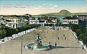
The square features a fountain in the middle and until the 1950s, street lights in the middle. Until the 1950s, trees used to exist by the square. Several shops are around the square. Ermou Street is to the north, Kanaris Street to the east, Votsis Street is to the south and Riga Fereou Street to the west.
The square features neo-classical buildings around and it had red shingles with arches.
Streets
Streets intersecting the square include;- Gerokostopoulou Street, west and east (one way westbound)
- Maizonos Street, northwest and southwest (one way southbound)
- Korinthou Street, southeast and northeast (one way eastbound)
all of them are on both sides.
Information

Stamatis Voulgaris
Stamatis Voulgaris was the first urban planner of modern Greece. He was born in Lefkimmi in the island of Corfu.An interesting incident led him to his decision to become an urban planner. During the Russian-Turkish siege , the San Giacomo theater of Corfu was in peril of fire when a cannon ball...
in 1829. The plan saw the light from the beginning in which Patras was destroyed during the battle of the Greek Revolution
Greek War of Independence
The Greek War of Independence, also known as the Greek Revolution was a successful war of independence waged by the Greek revolutionaries between...
. The plan included the creation of the new city next to the old with grid and horizontal streets and new large squares. During that time, the square began as Dimokratias (Δημοκρατίας), it later changed to Kalamogdarti (Καλαμογδάρτη), Othonos (Όθωνος) after Otto I of Greece, Central Square (Κεντρική Kentriki), Thomopoulou (Θωμόπουλου) after Thomopoulos, Ethniki (Εθνική, literally the national Square), Palligenesias (Παλλιγενεσίας) and since 1863, Georgiou I.
Landmarks next to the square include the Apollo Theatre, which was completed by Ernest Schiller. It was reconstructed several times, the last of which was in 2006. In the square, Periklis Kalamogdartis had its first constitution
Constitution
A constitution is a set of fundamental principles or established precedents according to which a state or other organization is governed. These rules together make up, i.e. constitute, what the entity is...
of Greece
Greece
Greece , officially the Hellenic Republic , and historically Hellas or the Republic of Greece in English, is a country in southeastern Europe....
and it was named after him for a while.
Many neoclassical buildings ceased to exist during World War II
World War II
World War II, or the Second World War , was a global conflict lasting from 1939 to 1945, involving most of the world's nations—including all of the great powers—eventually forming two opposing military alliances: the Allies and the Axis...
and the Greek Civil War
Greek Civil War
The Greek Civil War was fought from 1946 to 1949 between the Greek governmental army, backed by the United Kingdom and United States, and the Democratic Army of Greece , the military branch of the Greek Communist Party , backed by Bulgaria, Yugoslavia and Albania...
, mainly in the northeastern, the eastern and the southwestern sections. They have been replaced with eight to nine storey buildings completed in the 1960s. Since the 1950s, the GR-8
Greek National Road 8
The National Road 8 in Greece is a single carriageway with at-grade intersections in the Attica and Peloponnese regions. It links the cities of Patras, Corinth and Athens. Until the 1960s when the National Road 8A, a toll road, replaced it as a major route, it was the only road linking Athens and...
and the GR-9
Greek National Road 9
Greek National Road 9 is the second-longest national highway of Greece. It runs through the western Peloponnese, from Patras to Pylos. Its length is around .This highway travels near:*Bypasses:*Patras and Area, since 2002*Vrachneika*Alissos*Kato Achaia...
run through the square in which are now secondary routes, its primary route is to the west and the superhighway and the perimeter since 2001 are further east. Traffic lights were installed in the 1960s in Korinthou at the southeast side and Maizonos at the northwest side.
Renovation
In 2002, the square was renovated, tiles and fountains were renovated, another building in the northwest section was under construction and was completed by Fall of 2004 featuring several shops and escalators and resembling an outdoor mall with shops. The section from Maizonos and Korinthou and Korinthou and Maizonos were closed in order to alleviate traffic congestion which lasted for a couple of years. Traffic lights remain nowadays as pedestrian lights, one of the traffic lights at the older intersection remained, the other two were removed.Panorama
Its panorama includes the ArakynthosArakynthos
Arakynthos is a former municipality in Aetolia-Acarnania, West Greece, Greece. Since the 2011 local government reform it is part of the municipality Agrinio, of which it is a municipal unit. It consists of the villages of Ano Kerasovo, Kato Kerasovo, Zevgaraki, Papadates , Mataranga and Grammatikou....
mountains and the mountains of the Etoloakarnania
Aetolia-Acarnania
Aetolia-Acarnania is one of the regional units of Greece. It is part of the region of West Greece. It is located in the western part of Greece; the regional unit is a combination of the geographic regions Aetolia and Acarnania. Its capital is Missolonghi for historical reasons, with its biggest...
and Fokida prefecture
Prefectures of Greece
During the first administrative division of independent Greece in 1833–1836 and then again from 1845 until their abolition with the Kallikratis reform in 2010, the prefectures were the country's main administrative unit...
as well as the Panachaiko
Panachaiko
The Panachaikon or Panachaiko , also known as Vodias in medieval times and until the early 20th century, is a mountain range that spans about 20 km in length from north to south , and 15 to 20 km from east to west...
and the mountains to the southeast including Omplos
Omplos
Omplos is a mountain in the northern part of Achaea, Greece. It rises 720 m above sea level. The mountain is shaped like a sugar-loaf, with a 65° slope. The mountain can be reached by three unused roads, one that leads almost to the top of the mountain, one linking to Ovrya in the West, and...
and the south. The buildings block the panorama except for Gerostokopoulou and some views from the eastern portion.