
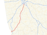
Georgia State Route 85
Encyclopedia
State Route 85 is a Georgia state route that begins in Columbus
and ends just west of Forest Park
in north Clayton County
. Besides Columbus, the route passes through only one county seat, Fayetteville
in Fayette County
. Georgia 85 is sometimes confused with Interstate 85
, which parallels it about twenty miles (32 km) to the west and also extends southwest from the Atlanta
area.
Columbus, Georgia
Columbus is a city in and the county seat of Muscogee County, Georgia, United States, with which it is consolidated. As of the 2010 census, the city had a population of 189,885. It is the principal city of the Columbus, Georgia metropolitan area, which, in 2009, had an estimated population of 292,795...
and ends just west of Forest Park
Forest Park, Georgia
Forest Park is a city in Clayton County, Georgia, United States. It is located approximately nine miles south of Atlanta and is part of the Atlanta–Sandy Springs–Marietta Metropolitan Statistical Area...
in north Clayton County
Clayton County, Georgia
Clayton County is a county located in the U.S. state of Georgia. As of 2000, the population was 236,517. The 2008 Census estimate placed the population at 273,718. The county seat is Jonesboro...
. Besides Columbus, the route passes through only one county seat, Fayetteville
Fayetteville, Georgia
Fayetteville is a town in Fayette County, Georgia, United States. As of the 2010 census, the city had a population of 15,945. The city is the county seat of Fayette County. Fayetteville is located approximately 22 miles from the city of Atlanta....
in Fayette County
Fayette County, Georgia
Fayette County is a county located in the U.S. state of Georgia. As of 2000, the population was 91,263. The 2007 Census Estimate shows a population of 106,144. The county seat is Fayetteville....
. Georgia 85 is sometimes confused with Interstate 85
Interstate 85
Interstate 85 is a major interstate highway in the Southeastern United States. Its current southern terminus is at an interchange with Interstate 65 in Montgomery, Alabama; its northern terminus interchanges with Interstate 95 in Petersburg, Virginia, near Richmond...
, which parallels it about twenty miles (32 km) to the west and also extends southwest from the Atlanta
Atlanta, Georgia
Atlanta is the capital and most populous city in the U.S. state of Georgia. According to the 2010 census, Atlanta's population is 420,003. Atlanta is the cultural and economic center of the Atlanta metropolitan area, which is home to 5,268,860 people and is the ninth largest metropolitan area in...
area.
Muscogee County
| Highway | Destination | Note(s) |
|---|---|---|
  U.S. 27 U.S. 27U.S. Route 27 U.S. Route 27 is a north–south United States highway in the southern and midwestern United States. The southern terminus is at US 1 in Miami, Florida. The northern terminus is at Interstate 69 in Fort Wayne, Indiana... /S.R. 1 |
Columbus Columbus, Georgia Columbus is a city in and the county seat of Muscogee County, Georgia, United States, with which it is consolidated. As of the 2010 census, the city had a population of 189,885. It is the principal city of the Columbus, Georgia metropolitan area, which, in 2009, had an estimated population of 292,795... |
Southern terminus GA 1 North to Hamilton; GA 1 South to Lumpkin |
  S.R. 22 Connector West S.R. 22 Connector West |
Columbus Columbus, Georgia Columbus is a city in and the county seat of Muscogee County, Georgia, United States, with which it is consolidated. As of the 2010 census, the city had a population of 189,885. It is the principal city of the Columbus, Georgia metropolitan area, which, in 2009, had an estimated population of 292,795... |
|
 S.R. 219 S.R. 219 |
Columbus Columbus, Georgia Columbus is a city in and the county seat of Muscogee County, Georgia, United States, with which it is consolidated. As of the 2010 census, the city had a population of 189,885. It is the principal city of the Columbus, Georgia metropolitan area, which, in 2009, had an estimated population of 292,795... |
GA 219 North to LaGrange |
  U.S. 27 U.S. 27U.S. Route 27 U.S. Route 27 is a north–south United States highway in the southern and midwestern United States. The southern terminus is at US 1 in Miami, Florida. The northern terminus is at Interstate 69 in Fort Wayne, Indiana... Alt East/U.S. 27 U.S. Route 27 U.S. Route 27 is a north–south United States highway in the southern and midwestern United States. The southern terminus is at US 1 in Miami, Florida. The northern terminus is at Interstate 69 in Fort Wayne, Indiana... /S.R. 1 |
Columbus Columbus, Georgia Columbus is a city in and the county seat of Muscogee County, Georgia, United States, with which it is consolidated. As of the 2010 census, the city had a population of 189,885. It is the principal city of the Columbus, Georgia metropolitan area, which, in 2009, had an estimated population of 292,795... |
GA 85 North joins US 27 Alt eastbound |
.svg.png)  I-185 I-185Interstate 185 (Georgia) Interstate 185 is a 49.30-mile secondary interstate in western Georgia. I-185 is also known as unsigned State Route 411, and is named the Chet Atkins Parkway for its entire length. It provides a freeway connection from Columbus and Fort Benning to Atlanta. Its southern terminus is at U.S. 27, U.S... /S.R. 411 |
Columbus Columbus, Georgia Columbus is a city in and the county seat of Muscogee County, Georgia, United States, with which it is consolidated. As of the 2010 census, the city had a population of 189,885. It is the principal city of the Columbus, Georgia metropolitan area, which, in 2009, had an estimated population of 292,795... |
I-185/GA 411 North to Atlanta; I-185/GA 411 South to Fort Benning |
  U.S. 80 U.S. 80U.S. Route 80 U.S. Route 80 is an east–west United States highway, much of which was once part of the early auto trail known as the Dixie Overland Highway. As the "0" in the route number indicates, it was originally a cross-country route, from the Atlantic to the Pacific... /S.R. 22 Georgia State Route 22 State Route 22 is a state route located in the central part of the U.S. state of Georgia. The route travels from the Alabama state line in Columbus east, then northeast, then north, to Comer.-Route description:... |
Midland | US 80 East to Talbotton; US 80 West to Phenix City, AL |
Harris County
| Highway | Destination | Note(s) |
|---|---|---|
   S.R. 315 S.R. 315Georgia State Route 315 State Route 315 is a west–east route in west central Georgia. From its western terminus at S.R. 219 in rural southwestern Harris County, the route runs east to its interchange with Interstate 185. The route continues east, passing through the towns of Cataula and Ellerslie. The route then... South |
Midland | GA 315 North joins US 27 Alt/GA 85 North; GA 315 South to Fortson |
 S.R. 315 S.R. 315Georgia State Route 315 State Route 315 is a west–east route in west central Georgia. From its western terminus at S.R. 219 in rural southwestern Harris County, the route runs east to its interchange with Interstate 185. The route continues east, passing through the towns of Cataula and Ellerslie. The route then... North |
Ellerslie Ellerslie, Georgia Ellerslie is an unincorporated town in Harris County, Georgia, United States. Ellerslie is a part of the columbus, georgia- metropolitan statistical area.-Notes:... |
GA 315 North leaves US 27 Alt/GA 85 North; GA 315 North to Talbotton |
 S.R. 208 S.R. 208Georgia State Route 208 State Route 208 is known as the Old Federal Road or the Wire Road. State Route 208 begins in Harris County at U.S. Route 27 near Hamilton and ends in Fickling Mill at the junction of State Route 137. The Wesley and Jarrell communities are located on this route in Taylor County.... |
Waverly Hall Waverly Hall, Georgia Waverly Hall is a town in Harris County, Georgia. It is part of the Columbus, Georgia-Alabama Metropolitan Statistical Area. The population was 709 at the 2000 census.-Geography:Waverly Hall is located at .... |
GA 208 East to Talbotton; GA 208 West to Cataula |
Talbot County
| Highway | Destination | Note(s) |
|---|---|---|
  S.R. 116 S.R. 116Georgia State Route 116 State Route 116 is a Georgia state route that runs through Harris County. The route begins north of Fortson at the junction of S.R. 103 and I-185. The route then merges with S.R. 85 in Shiloh.... West |
Shiloh | US 27 Alt leaves/GA 116 West to Shiloh GA 116 East joins GA 85 North |
| S.R. 116 Georgia State Route 116 State Route 116 is a Georgia state route that runs through Harris County. The route begins north of Fortson at the junction of S.R. 103 and I-185. The route then merges with S.R. 85 in Shiloh.... East |
Woodland Woodland, Georgia Woodland is a city in Talbot County, Georgia, United States. The population was 432 at the 2000 census.-Geography:Woodland is located at .According to the United States Census Bureau, the city has a total area of , all of it land.... |
GA 116 East leaves GA 85 North to go to Woodland |
 S.R. 41 S.R. 41Georgia State Route 41 State Route 41 is a north–south state route located in the western part of the U.S. state of Georgia. The route travels from State Route 45 north of Morgan north to U.S. Route 29/State Route 14 in Moreland.-Route description:... South |
Woodland Woodland, Georgia Woodland is a city in Talbot County, Georgia, United States. The population was 432 at the 2000 census.-Geography:Woodland is located at .According to the United States Census Bureau, the city has a total area of , all of it land.... |
GA 41 North joins GA 85 North; GA 41 South to Woodland |
Meriwether County
| Highway | Destination | Note(s) |
|---|---|---|
 S.R. 190 S.R. 190Georgia State Route 190 State Route 190 runs solely through FDR State Park and is a scenic route. Also connects Manchester and the proximity of Pine Mountain.... West |
Manchester Manchester, Georgia Manchester is a city located in Meriwether and Talbot Counties in the U.S. state of Georgia, although primarily in Meriwether. The population was 3,769 at the 2010 census.-Demographics:... |
GA 190 East joins GA 41/85 North |
| S.R. 41 Georgia State Route 41 State Route 41 is a north–south state route located in the western part of the U.S. state of Georgia. The route travels from State Route 45 north of Morgan north to U.S. Route 29/State Route 14 in Moreland.-Route description:... |
Manchester Manchester, Georgia Manchester is a city located in Meriwether and Talbot Counties in the U.S. state of Georgia, although primarily in Meriwether. The population was 3,769 at the 2010 census.-Demographics:... |
GA 41 North leave GA 85 North/GA 190 East GA 41 North to Warm Springs |
 Georgia State Route 85 Spur North Georgia State Route 85 Spur North |
Manchester Manchester, Georgia Manchester is a city located in Meriwether and Talbot Counties in the U.S. state of Georgia, although primarily in Meriwether. The population was 3,769 at the 2010 census.-Demographics:... |
|
| S.R. 190 Georgia State Route 190 State Route 190 runs solely through FDR State Park and is a scenic route. Also connects Manchester and the proximity of Pine Mountain.... East |
Manchester Manchester, Georgia Manchester is a city located in Meriwether and Talbot Counties in the U.S. state of Georgia, although primarily in Meriwether. The population was 3,769 at the 2010 census.-Demographics:... |
This is the end of the GA 85/190 concurrency |
    S.R. 109 S.R. 109Georgia State Route 109 State Route 109 Spur connects SR 18 and SR 109 next to Greenville to SR 74/SR 85 in Gay. This road was designated because of the long distance on SR 74/SR 85 connecting Gay and SR 109 in Woodbury. This also helps smooth traffic going to the Cotton Pickin' Fair in Gay.... /S.R. 18 Georgia State Route 18 State Route 18 is a west–east route located in the U.S. state of Georgia. The route runs from its western terminus at U.S. 29/S.R. 14 in West Point east to its eastern terminus at U.S. 80/S.R. 19/S.R. 96 in Jeffersonville.... /S.R. 74 Georgia State Route 74 State Route 74 starts in Macon at I-75 and ends at Roosevelt Highway , just southwest of Historic Downtown Fairburn.-Bibb County:-Monroe County:-Upson County:-Pike County:-Meriwether County:-Coweta County:-Fayette County:... South |
Woodbury Woodbury, Georgia Woodbury is a city in Meriwether County, Georgia, United States. The population was 1,184 at the 2000 census.- History :Woodbury is one of the oldest towns in Meriwether County. It grew up about ten miles southeast of Greenville in the late 1820s. It was first named Sandtown for the white sand that... |
GA 74 North joins GA 85 North GA 18 East/109 North to Molena; GA 18/109 South to Greenville |
| S.R. 85 Alt South |
Woodbury Woodbury, Georgia Woodbury is a city in Meriwether County, Georgia, United States. The population was 1,184 at the 2000 census.- History :Woodbury is one of the oldest towns in Meriwether County. It grew up about ten miles southeast of Greenville in the late 1820s. It was first named Sandtown for the white sand that... |
|
 S.R. 109 S.R. 109Georgia State Route 109 State Route 109 Spur connects SR 18 and SR 109 next to Greenville to SR 74/SR 85 in Gay. This road was designated because of the long distance on SR 74/SR 85 connecting Gay and SR 109 in Woodbury. This also helps smooth traffic going to the Cotton Pickin' Fair in Gay.... Spur West |
Gay Gay, Georgia Gay is a town in Meriwether County, Georgia, United States. The population was 89 at the 2010 census.-Geography:Gay is located at .According to the United States Census Bureau, the town has a total area of , all of it land.... |
|
 S.R. 362 West S.R. 362 West |
Gay Gay, Georgia Gay is a town in Meriwether County, Georgia, United States. The population was 89 at the 2010 census.-Geography:Gay is located at .According to the United States Census Bureau, the town has a total area of , all of it land.... |
GA 362 East joins GA 74/85 North GA 362 West to Greenville |
| S.R. 362 East |
Gay Gay, Georgia Gay is a town in Meriwether County, Georgia, United States. The population was 89 at the 2010 census.-Geography:Gay is located at .According to the United States Census Bureau, the town has a total area of , all of it land.... |
GA 362 leaves GA 74/85 North GA 362 East to Griffin |
Coweta County
| Highway | Destination | Note(s) |
|---|---|---|
 S.R. 16 S.R. 16Georgia State Route 16 State Route 16 begins at SR 100 in Haralson County, just south of I-20, and ends at U.S. 278 in Warrenton.-Major junctions:... |
Senoia Senoia, Georgia Senoia is a city in Coweta County, Georgia, United States. The population was 1,738 at the 2000 census... |
GA 16 East to Griffin; GA 16 West to Newnan |
Fayette County
| Highway | Destination | Note(s) |
|---|---|---|
| S.R. 74 Georgia State Route 74 State Route 74 starts in Macon at I-75 and ends at Roosevelt Highway , just southwest of Historic Downtown Fairburn.-Bibb County:-Monroe County:-Upson County:-Pike County:-Meriwether County:-Coweta County:-Fayette County:... West |
Fayetteville Fayetteville, Georgia Fayetteville is a town in Fayette County, Georgia, United States. As of the 2010 census, the city had a population of 15,945. The city is the county seat of Fayette County. Fayetteville is located approximately 22 miles from the city of Atlanta.... |
End of GA 74/85 concurrency GA 74 West to Peachtree City |
 Georgia State Route 85 Connector South Georgia State Route 85 Connector South |
Fayetteville Fayetteville, Georgia Fayetteville is a town in Fayette County, Georgia, United States. As of the 2010 census, the city had a population of 15,945. The city is the county seat of Fayette County. Fayetteville is located approximately 22 miles from the city of Atlanta.... |
|
 S.R. 92 S.R. 92Georgia State Route 92 State Route 92 is a highway in the U.S. state of Georgia. The road runs for from Griffin to Roswell. Primarily signed from south to north, Route 92 is a rural route that passes through three county seats.- Route description :... South |
Fayetteville Fayetteville, Georgia Fayetteville is a town in Fayette County, Georgia, United States. As of the 2010 census, the city had a population of 15,945. The city is the county seat of Fayette County. Fayetteville is located approximately 22 miles from the city of Atlanta.... |
GA 92 North joins GA 85 North; GA 92 South to Griffin |
 S.R. 54 S.R. 54Georgia State Route 54 State Route 54 starts at US 27/SR 1 in Troup County and ends in southwest Atlanta, as University Avenue, at the Downtown Connector .In Clayton County, SR 54 passes by Southlake Mall , a shopping mall.... |
Fayetteville Fayetteville, Georgia Fayetteville is a town in Fayette County, Georgia, United States. As of the 2010 census, the city had a population of 15,945. The city is the county seat of Fayette County. Fayetteville is located approximately 22 miles from the city of Atlanta.... |
GA 54 West to Peachtree City; GA 54 East to Jonesboro |
| S.R. 92 Georgia State Route 92 State Route 92 is a highway in the U.S. state of Georgia. The road runs for from Griffin to Roswell. Primarily signed from south to north, Route 92 is a rural route that passes through three county seats.- Route description :... North |
Fayetteville Fayetteville, Georgia Fayetteville is a town in Fayette County, Georgia, United States. As of the 2010 census, the city had a population of 15,945. The city is the county seat of Fayette County. Fayetteville is located approximately 22 miles from the city of Atlanta.... |
End of GA 85/92 concurrency; GA 92 North to Fairburn |
 S.R. 314 S.R. 314Georgia State Route 314 State Route 314 begins at S.R. 85 in Fayetteville and ends at Riverdale Road in College Park in north Clayton County. The route is mostly residential until entering the Fayetteville city limits, where there has been a recent commercial boom.... North |
Fayetteville Fayetteville, Georgia Fayetteville is a town in Fayette County, Georgia, United States. As of the 2010 census, the city had a population of 15,945. The city is the county seat of Fayette County. Fayetteville is located approximately 22 miles from the city of Atlanta.... |
GA 314 North to College Park |
 S.R. 279 S.R. 279Georgia State Route 279 State Route 279 is a Georgia state route in south Fulton County and north Fayette County. Old National Highway, as it is best known, connects S.R. 85 with Roosevelt Highway in College Park.... North |
Fayetteville Fayetteville, Georgia Fayetteville is a town in Fayette County, Georgia, United States. As of the 2010 census, the city had a population of 15,945. The city is the county seat of Fayette County. Fayetteville is located approximately 22 miles from the city of Atlanta.... |
GA 279 North to College Park |
Clayton County
| Highway | Destination | Note(s) |
|---|---|---|
 S.R. 138 S.R. 138Georgia State Route 138 State Route 138 is a highway in the U.S. state of Georgia. The highway is an east–west route that begins at the junction of S.R. 92 just north of Fairburn and ends at U.S. 78/S.R. 10 near Monroe. It totals approximately in length... |
Riverdale Riverdale, Georgia Riverdale is a city in Clayton County, Georgia, United States. The population was 12,478 at the 2000 census.-Geography:Riverdale is located at .-Demographics:... |
GA 138 East to Stockbridge; GA 138 West to Union City |
 S.R. 139 S.R. 139Georgia State Route 139 State Route 139 is a Georgia state route that starts in Clayton County at S.R. 85 in Riverdale, and ends at Veterans Memorial Highway in Mableton. The portion of S.R. 139 in College Park has been rerouted around the new Atlanta Airport runway, which crosses over I-285.... North |
Riverdale Riverdale, Georgia Riverdale is a city in Clayton County, Georgia, United States. The population was 12,478 at the 2000 census.-Geography:Riverdale is located at .-Demographics:... |
GA 139 North to College Park |
 S.R. 331 S.R. 331Georgia State Route 331 State Route 331 is a Georgia state route in northern Clayton County. Its western terminus is at S.R. 85 just west of Interstate 75 exit 237, from which it proceeds east through Forest Park for approximately to an intersection with S.R. 54 near Lake City, where it ends.Also known as Forest... |
Forest Park Forest Park, Georgia Forest Park is a city in Clayton County, Georgia, United States. It is located approximately nine miles south of Atlanta and is part of the Atlanta–Sandy Springs–Marietta Metropolitan Statistical Area... |
GA 331 East to Lake City |
   I-75/S.R. 401 North I-75/S.R. 401 North |
Forest Park Forest Park, Georgia Forest Park is a city in Clayton County, Georgia, United States. It is located approximately nine miles south of Atlanta and is part of the Atlanta–Sandy Springs–Marietta Metropolitan Statistical Area... |
Northern terminus For access to I-75/GA 401 South, use GA 331/Forest Parkway |