
Georgia State Route 92
Encyclopedia
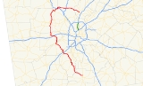
State Route 92 is a highway in the U.S. state
of Georgia
. The road runs for 98 miles (157.7 km) from Griffin
to Roswell
. Primarily signed from south to north, Route 92 is a rural route that passes through three county seats.
and ends at the intersection of Alpharetta
Highway (Georgia 9, co-signed Georgia 120) and Holcomb Bridge Road (Georgia 140) in Roswell
. It is predominantly a rural
route, passing through three county seats: Griffin, Fayetteville
and Douglasville
.
Despite the fact that 92 is an even-numbered highway, the highway is primarily signed north/south, although there are some signs showing an east/west direction.
The Georgia 92 bridge over Lake Allatoona in Acworth is a mini-dam separating Lake Allatoona from its major tributary, Lake Acworth.
.
, and then overlapped U.S. 278 going east, before breaking-off going into Douglasville. In the 1970s, the routing was changed onto Bobo Road, with the old section going into Dallas designated as 92 Spur. In the late 1970s, the designation moved into its current position near and in some places right on the Cobb County line, on Hiram Acworth Highway, also called County Line Road. North of here it is on Dallas Acworth Highway, which formerly became Acworth Dallas Highway in Cobb.
In 1977, Southern Airways Flight 242
crashed onto Georgia 92 Spur in New Hope
, killing 63 passengers and nine people on the ground. A nearby convenience store
was destroyed as a result.
In 1981, Georgia 92 Spur became Georgia 381, which was deleted in the mid 1990s.
A banner route, Georgia 92 Connector, also existed on what is today East Paulding Drive. It later became Georgia 120 Connector before being deleted.
on Sandy Plains Road, signs for 92 "north" point south (right turn), even though Roswell is east, and signs for 92 "south" point north (left turn), even though Woodstock is west.
Georgia 92 originally was routed through downtown Acworth, concurrent with old U.S. 41 on Main Street. As a result of the da
mming of Lake Allatoona
, the road was rerouted onto a newly-created stretch of road, Lake Acworth Drive from the new four-laned U.S. 41 (Cobb Parkway
) to Main Street. The older routing has been flooded as part of the lake. In the mid-1970s, an overpass
over Main Street was constructed, and 92 was rerouted on this new stretch of Lake Acworth Drive connecting to Cherokee Street. The bridge (within Cobb County Regional Park around the lake) is also the dam for Lake Acworth, which existed before Allatoona, and now empties directly into it. 92 is concurrent with 41 for part of the way, then makes an acute turn back south on Dallas Acworth Highway, its routing before the lake was flooded. The Cobb section was originally Acworth Dallas Highway, following local naming conventions that avoid confusion with Dallas Highway (Georgia 120) from Marietta (not prefixed because it is the county seat).
The reconstruction of the diamond interchange
at Interstate 75
, which is immediately inside the line from Bartow and Cherokee counties, was nearly complete , and cost over 16.4 million dollars. http://www.cumminghome.com/news30041/Government/georgia-dot-gears-up-for-summer-construction-seaso.shtml This is related to the widening of 92 to the north and west of this point in Cherokee, although it was a separate contract. This short section is called Cherokee Road and is in the unincorporated part of Cobb. At the southern edge of the intersection is the Acworth city limit, and it is at this point (34.0779°N 84.6533°W), rather than the more logical intersection just a few yards or meters south, that it becomes Cowan Road. At that intersection, Cowan continues south, 92 "south" turns west on Lake Acworth Drive, and that street continues east (parallel to 75 "south") as Baker Road.
Road in the late 1960s.
As the road west ("south") of Woodstock
has been widened in the late 2000s, it has been straightened and the path has been moved by several hundred yards or meters (34.093°N 84.651°W) in three places, including a major viaduct
over the flood plain of a stream
near the lake. The part from Woodstock to Roswell was widened this way in the 1990s. Since then, the area has developed
rapidly.
The section within the city limit of Woodstock and west of former Georgia 5 (Main Street to the north and Canton Road to the south), is the main business district for the town, outside of downtown
. This section has an average of four lanes in each direction, plus several turn lanes, and the diamond interchange
with Interstate 575
. It also crosses Noonday Creek
, which briefly closed the road in 1995 when major flooding occurred after very heavy rains caused by Hurricane Dennis
, which quickly followed Hurricane Cindy
.
.
U.S. state
A U.S. state is any one of the 50 federated states of the United States of America that share sovereignty with the federal government. Because of this shared sovereignty, an American is a citizen both of the federal entity and of his or her state of domicile. Four states use the official title of...
of Georgia
Georgia (U.S. state)
Georgia is a state located in the southeastern United States. It was established in 1732, the last of the original Thirteen Colonies. The state is named after King George II of Great Britain. Georgia was the fourth state to ratify the United States Constitution, on January 2, 1788...
. The road runs for 98 miles (157.7 km) from Griffin
Griffin, Georgia
Griffin is a city in and the county seat of Spalding County in the U.S. state of Georgia. It is part of the Atlanta metropolitan area. As of the 2010 census, the city had a population of 23,643.-Geography:Griffin is located at ....
to Roswell
Roswell, Georgia
Roswell is a city located in northern Fulton County; it is a suburb of northern Atlanta, Georgia, United States. The 2010 Census population was 88,346. It is the eighth largest city in Georgia...
. Primarily signed from south to north, Route 92 is a rural route that passes through three county seats.
Route description
The highway begins at Taylor Street (U.S. 19 Business/U.S. 41 Business/Georgia 16) in GriffinGriffin, Georgia
Griffin is a city in and the county seat of Spalding County in the U.S. state of Georgia. It is part of the Atlanta metropolitan area. As of the 2010 census, the city had a population of 23,643.-Geography:Griffin is located at ....
and ends at the intersection of Alpharetta
Alpharetta, Georgia
-Demographics:As of the census of 2000, there were 34,854 people, 13,911 households, and 8,916 families residing in the city. The population density was 1,631.6 people per square mile . There were 14,670 housing units at an average density of 686.7 per square mile...
Highway (Georgia 9, co-signed Georgia 120) and Holcomb Bridge Road (Georgia 140) in Roswell
Roswell, Georgia
Roswell is a city located in northern Fulton County; it is a suburb of northern Atlanta, Georgia, United States. The 2010 Census population was 88,346. It is the eighth largest city in Georgia...
. It is predominantly a rural
Rural
Rural areas or the country or countryside are areas that are not urbanized, though when large areas are described, country towns and smaller cities will be included. They have a low population density, and typically much of the land is devoted to agriculture...
route, passing through three county seats: Griffin, Fayetteville
Fayetteville, Georgia
Fayetteville is a town in Fayette County, Georgia, United States. As of the 2010 census, the city had a population of 15,945. The city is the county seat of Fayette County. Fayetteville is located approximately 22 miles from the city of Atlanta....
and Douglasville
Douglasville, Georgia
The city of Douglasville is the county seat of Douglas County, Georgia, United States. As of the 2010 census, the city had a population of 30,961...
.
Despite the fact that 92 is an even-numbered highway, the highway is primarily signed north/south, although there are some signs showing an east/west direction.
The Georgia 92 bridge over Lake Allatoona in Acworth is a mini-dam separating Lake Allatoona from its major tributary, Lake Acworth.
Spalding County
Georgia 92 originally terminated at US 19/41. It was extended to is current terminus when the Griffin Bypass was built, and the Old US 19/41 became a business routeBusiness route
A business route in the United States and Canada is a short special route connected to a parent numbered highway at its beginning, then routed through the central business district of a nearby city or town, and finally reconnecting with the same parent numbered highway again at its...
.
Douglas County
Farburn Road Georgia State Route 92 began as a connector from Douglasville to U.S. 278 in Hiram. It was slowly expanded to the route of today that roughly forms a western by-pass of Atlanta connecting suburban towns. Since the road evolved in what were extremely rural counties and joined together along previously existing county roads, the highway saw tremendous relocation during the mid to late 20th century.Paulding County
Georgia 92 was originally routed into DallasDallas, Georgia
Dallas is a city in and the county seat of Paulding County, Georgia, United States. As of the 2010 census, the city had a population of 11,544. It was named for George M. Dallas, Vice President of the United States of America under James K. Polk.-History:...
, and then overlapped U.S. 278 going east, before breaking-off going into Douglasville. In the 1970s, the routing was changed onto Bobo Road, with the old section going into Dallas designated as 92 Spur. In the late 1970s, the designation moved into its current position near and in some places right on the Cobb County line, on Hiram Acworth Highway, also called County Line Road. North of here it is on Dallas Acworth Highway, which formerly became Acworth Dallas Highway in Cobb.
In 1977, Southern Airways Flight 242
Southern Airways Flight 242
Southern Airways Flight 242 was a DC-9-31 jet, registered N1335U, that executed a forced landing on a highway in New Hope, Paulding County, Georgia, United States after suffering hail damage and losing thrust on both engines in a severe thunderstorm on April 4, 1977.At the time of the accident, the...
crashed onto Georgia 92 Spur in New Hope
New Hope, Georgia
New Hope is an unincorporated community in Paulding County, Georgia. Once considered a rural destination, New Hope is now an exurb of Atlanta, located at the crossroads of Dallas-Acworth Highway and East Paulding Drive/Old Cartersville Road...
, killing 63 passengers and nine people on the ground. A nearby convenience store
Convenience store
A convenience store, corner store, corner shop, commonly called a bodega in Spanish-speaking areas of the United States, is a small store or shop in a built up area that stocks a range of everyday items such as groceries, toiletries, alcoholic and soft drinks, and may also offer money order and...
was destroyed as a result.
In 1981, Georgia 92 Spur became Georgia 381, which was deleted in the mid 1990s.
A banner route, Georgia 92 Connector, also existed on what is today East Paulding Drive. It later became Georgia 120 Connector before being deleted.
Cobb County
Georgia 92 enters Cobb County in three separate non-adjoining places in different parts of the county. In addition to the Acworth section, 92 also enters Cobb County just north of East Paulding Drive to just south of Due West Road. It also makes a brief entrance at the intersection of Sandy Plains Road. Upon reaching the northeast end while drivingDriving
Driving is the controlled operation and movement of a land vehicle, such as a car, truck or bus.Although direct operation of a bicycle and a mounted animal are commonly referred to as riding, such operators are legally considered drivers and are required to obey the rules of the road...
on Sandy Plains Road, signs for 92 "north" point south (right turn), even though Roswell is east, and signs for 92 "south" point north (left turn), even though Woodstock is west.
Georgia 92 originally was routed through downtown Acworth, concurrent with old U.S. 41 on Main Street. As a result of the da
DA
DA, da, or dA may refer to:* Da , a Tony-winning play by Hugh Leonard* Da , a movie adaptation of the play by Hugh Leonard* Adi Da, a spiritual leader once known as Da Free John, and Da Love-Ananda...
mming of Lake Allatoona
Lake Allatoona
Lake Allatoona is a U.S. Army Corps of Engineers reservoir in Georgia, located in northwestern metro Atlanta. The lake is mostly in southwestern Cherokee County, but a significant part is in southeastern Bartow County, and a small part in Cobb County near Acworth. Cartersville is the nearest...
, the road was rerouted onto a newly-created stretch of road, Lake Acworth Drive from the new four-laned U.S. 41 (Cobb Parkway
Cobb Parkway
Cobb Parkway is a major arterial road which runs northwest and southeast through Cobb County, Georgia. It concurrently carries both U.S. 41, and the much less-recognized Georgia 3...
) to Main Street. The older routing has been flooded as part of the lake. In the mid-1970s, an overpass
Overpass
An overpass is a bridge, road, railway or similar structure that crosses over another road or railway...
over Main Street was constructed, and 92 was rerouted on this new stretch of Lake Acworth Drive connecting to Cherokee Street. The bridge (within Cobb County Regional Park around the lake) is also the dam for Lake Acworth, which existed before Allatoona, and now empties directly into it. 92 is concurrent with 41 for part of the way, then makes an acute turn back south on Dallas Acworth Highway, its routing before the lake was flooded. The Cobb section was originally Acworth Dallas Highway, following local naming conventions that avoid confusion with Dallas Highway (Georgia 120) from Marietta (not prefixed because it is the county seat).
The reconstruction of the diamond interchange
Diamond interchange
A diamond interchange is a common type of road junction, used where a freeway crosses a minor road. The freeway itself is grade-separated from the minor road, one crossing the other over a bridge...
at Interstate 75
Interstate 75
Interstate 75 is a major north–south Interstate Highway in the Great Lakes and Southeastern regions of the United States. It travels from State Road 826 and State Road 924 in Hialeah, Florida to Sault Ste. Marie, Michigan, at the Ontario, Canada, border...
, which is immediately inside the line from Bartow and Cherokee counties, was nearly complete , and cost over 16.4 million dollars. http://www.cumminghome.com/news30041/Government/georgia-dot-gears-up-for-summer-construction-seaso.shtml This is related to the widening of 92 to the north and west of this point in Cherokee, although it was a separate contract. This short section is called Cherokee Road and is in the unincorporated part of Cobb. At the southern edge of the intersection is the Acworth city limit, and it is at this point (34.0779°N 84.6533°W), rather than the more logical intersection just a few yards or meters south, that it becomes Cowan Road. At that intersection, Cowan continues south, 92 "south" turns west on Lake Acworth Drive, and that street continues east (parallel to 75 "south") as Baker Road.
Cherokee County
Georgia 92 originally was routed onto Kellogg Creek Road and portions of Bells Ferry Road. The road was rerouted to its present route, along the entire length (within the county) of AlabamaAlabama
Alabama is a state located in the southeastern region of the United States. It is bordered by Tennessee to the north, Georgia to the east, Florida and the Gulf of Mexico to the south, and Mississippi to the west. Alabama ranks 30th in total land area and ranks second in the size of its inland...
Road in the late 1960s.
As the road west ("south") of Woodstock
Woodstock, Georgia
Woodstock is a city in Cherokee County, Georgia, United States. The population was 23,896 at the 2010 census.Originally a stop on the Louisville and Nashville Railroad, Woodstock is now considered part of the Atlanta metropolitan area...
has been widened in the late 2000s, it has been straightened and the path has been moved by several hundred yards or meters (34.093°N 84.651°W) in three places, including a major viaduct
Viaduct
A viaduct is a bridge composed of several small spans. The term viaduct is derived from the Latin via for road and ducere to lead something. However, the Ancient Romans did not use that term per se; it is a modern derivation from an analogy with aqueduct. Like the Roman aqueducts, many early...
over the flood plain of a stream
Stream
A stream is a body of water with a current, confined within a bed and stream banks. Depending on its locale or certain characteristics, a stream may be referred to as a branch, brook, beck, burn, creek, "crick", gill , kill, lick, rill, river, syke, bayou, rivulet, streamage, wash, run or...
near the lake. The part from Woodstock to Roswell was widened this way in the 1990s. Since then, the area has developed
Land development
Land development refers to altering the landscape in any number of ways such as:* changing landforms from a natural or semi-natural state for a purpose such as agriculture or housing...
rapidly.
The section within the city limit of Woodstock and west of former Georgia 5 (Main Street to the north and Canton Road to the south), is the main business district for the town, outside of downtown
Downtown
Downtown is a term primarily used in North America by English speakers to refer to a city's core or central business district ....
. This section has an average of four lanes in each direction, plus several turn lanes, and the diamond interchange
Diamond interchange
A diamond interchange is a common type of road junction, used where a freeway crosses a minor road. The freeway itself is grade-separated from the minor road, one crossing the other over a bridge...
with Interstate 575
Interstate 575
Interstate 575 is an Interstate Highway spur route in the United States, which branches off Interstate 75 in Kennesaw and connects the metro Atlanta area with the north Georgia mountains. I-575 is also the unsigned State Route 417 and is cosigned as SR 5...
. It also crosses Noonday Creek
Noonday Creek
Noonday Creek is a stream in Cobb and Cherokee counties in the U.S. state of Georgia. The stream begins near Kennesaw Mountain and ends at Lake Allatoona.-Geography:...
, which briefly closed the road in 1995 when major flooding occurred after very heavy rains caused by Hurricane Dennis
Hurricane Dennis
Hurricane Dennis was an early-forming major hurricane in the Caribbean and Gulf of Mexico during the very active 2005 Atlantic hurricane season. Dennis was the fourth named storm, second hurricane, and first major hurricane of the season...
, which quickly followed Hurricane Cindy
Hurricane Cindy
The name Cindy has been used for eight tropical cyclones in the Atlantic Ocean.* 1959's Hurricane Cindy – caused minor damage to South Carolina.* 1963's Hurricane Cindy – caused $12 million damage and three deaths in Texas and Louisiana....
.
Fulton County
Georgia 92 terminated at Sandy Plains Road in extreme northeast Cobb County until the 1980s, when it was extended to its present-day terminus at Georgia 9 (Alpharetta Highway, north/south), 120 (south/east), and 140 (north/east). During the late-1980s or early-1990s widening, this section was made from two undivided lanes to be six lanes with a raised median. Entirely within the city limits of Roswell, it is known as Crossville Road near the town. On the west side, it is part of Woodstock Road which turns off to the southeast toward the town squareTown square
A town square is an open public space commonly found in the heart of a traditional town used for community gatherings. Other names for town square are civic center, city square, urban square, market square, public square, and town green.Most town squares are hardscapes suitable for open markets,...
.