
Georgia State Route 39
Encyclopedia
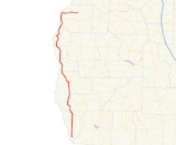
State Route 39 is a north–south state route located in the southwestern part of the U.S. state
of Georgia
. The route travels from Lake Seminole
in southern Seminole County
north to U.S. 27
/SR 1
north of Lumpkin
.
, where it is briefly cosigned
with State Route 91. After intersecting U.S. Route 84
/State Route 38
, the routes continue to the north side of the city, where State Route 39 departs and continues north into Miller County
. After briefly travelling north in Miller County, the route jogs to the west into Early County
, where it resumes its northward route to Blakely
. In Blakely, State Route 39 becomes cosigned with U.S. Route 27 Business / State Route 1 Business north through downtown. On the north side of the city, State Route 39 departs U.S. Route 27 Business/State Route 1 Business, and, after briefly traveling west cosigned with State Route 62 Bypass
, continues north to Fort Gaines
, where it is briefly cosigned with State Route 37
. North of Fort Gaines, State Route 39 runs along the eastern shore of Walter F. George Lake
, and passes through George T. Bagby State Park
. Southeast of Georgetown
, the route becomes cosigned with U.S. Route 82
/State Route 50
westward. Just to the east of Georgetown, State Route 39 departs to the north, running parallel to the Chattahoochee River
. Shortly after passing Florence Marina State Park
, the route takes a drastic turn to the east at Omaha where it meets State Route 39 Spur, and continues east to its northern terminus at U.S. Route 27/State Route 1 north of Lumpkin.
State Route 39 is a rural route, and as a result, sees very little traffic. Most of the route sees an Average Annual Daily Traffic of less than 2,000 vehicles.
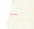 State Route 39 Connector is a 15.84 mile route connecting the State Route 39 mainline near Florence Marina State Park with U.S. Route 27 in Lumpkin. The route passes through Providence Canyon State Park
.
State Route 39 Spur is a short spur that runs from the State Route 39 mainline in Omaha westward. After crossing the Chattahoochee River into Alabama
, the route becomes Alabama State Route 208
.
U.S. state
A U.S. state is any one of the 50 federated states of the United States of America that share sovereignty with the federal government. Because of this shared sovereignty, an American is a citizen both of the federal entity and of his or her state of domicile. Four states use the official title of...
of Georgia
Georgia (U.S. state)
Georgia is a state located in the southeastern United States. It was established in 1732, the last of the original Thirteen Colonies. The state is named after King George II of Great Britain. Georgia was the fourth state to ratify the United States Constitution, on January 2, 1788...
. The route travels from Lake Seminole
Lake Seminole
Lake Seminole is a reservoir located in the southwest corner of Georgia along its border with Florida, maintained by the U.S. Army Corps of Engineers. The Chattahoochee and Flint rivers join in the lake, before flowing from the Jim Woodruff Lock and Dam, which impounds the lake, as the Apalachicola...
in southern Seminole County
Seminole County, Georgia
Seminole County is a county located in the U.S. state of Georgia. As of 2000, the population was 9,369. The 2007 Census Estimate shows a population of 9,081. The county seat is Donalsonville.-History:...
north to U.S. 27
U.S. Route 27
U.S. Route 27 is a north–south United States highway in the southern and midwestern United States. The southern terminus is at US 1 in Miami, Florida. The northern terminus is at Interstate 69 in Fort Wayne, Indiana...
/SR 1
U.S. Route 27 in Georgia
In the U.S. state of Georgia, U.S. Route 27 runs north–south near the western border . The whole route is Governor's Road Improvement Program corridor EDS-27, providing the bulk of the Tallahassee, Florida - Chattanooga, Tennessee corridor. All of US 27 in Georgia is designated State Route 1...
north of Lumpkin
Lumpkin, Georgia
Lumpkin is a city in, and the county seat of, Stewart County, Georgia, United States. The population was 1,369 at the 2000 census.-History:This area of Georgia was inhabited by indigenous Native Americans for thousands of years before European contact...
.
Route description
From its southern terminus at Lake Seminole, State Route 39 travels north to DonalsonvilleDonalsonville, Georgia
Donalsonville is a city in Seminole County, Georgia, United States. The population was 2,796 at the 2000 census. The city is the county seat of Seminole County.-History:...
, where it is briefly cosigned
Concurrency (road)
A concurrency, overlap, or coincidence in a road network is an instance of one physical road bearing two or more different highway, motorway, or other route numbers...
with State Route 91. After intersecting U.S. Route 84
U.S. Route 84
U.S. Route 84 is an east–west United States highway. It started as a short Georgia-Alabama route in the original 1926 scheme, but now extends all the way to Colorado. The highway's eastern terminus is a short distance east of Midway, Georgia, at an intersection with I-95. The road continues...
/State Route 38
U.S. Route 84 in Georgia
U.S. Route 84 in Georgia, is also signed as State Route 38 for its entire length in Georgia. After entering Georgia from Alabama west of Jakin, Georgia, the route travels through the southern portion of the state, meeting its eastern terminus at Interstate 95 east of Midway. U.S...
, the routes continue to the north side of the city, where State Route 39 departs and continues north into Miller County
Miller County, Georgia
Miller County is a county located in the U.S. state of Georgia. It was created on February 26, 1856. As of 2000, the population was 6,383. The 2007 Census Estimate shows a population of 6,163. The county seat is Colquitt.-Geography:...
. After briefly travelling north in Miller County, the route jogs to the west into Early County
Early County, Georgia
Early County is a county located in the U.S. state of Georgia. It was created on December 15, 1818 and was named for Peter Early. As of 2010, the population is 11,008. The county seat is Blakely.-Geography:...
, where it resumes its northward route to Blakely
Blakely, Georgia
Blakely is a town in Early County, Georgia. As of the 2010 census, the city had a population of 5,068. This town is the county seat of Early County.-Geography:Blakely is located at ....
. In Blakely, State Route 39 becomes cosigned with U.S. Route 27 Business / State Route 1 Business north through downtown. On the north side of the city, State Route 39 departs U.S. Route 27 Business/State Route 1 Business, and, after briefly traveling west cosigned with State Route 62 Bypass
Georgia State Route 62
Georgia State Route 62 is a state route in southwest Georgia that runs from the Georgia-Alabama line near Hilton to State Route 234 in Albany.- Routing :...
, continues north to Fort Gaines
Fort Gaines, Georgia
Fort Gaines is a city in Clay County, Georgia, United States. The population was 1,110 at the 2000 census. The city is the county seat of Clay County.-Geography:Fort Gaines is located at ....
, where it is briefly cosigned with State Route 37
Georgia State Route 37
State Route 37 is a west–east state route located in the southern part of the U.S. state of Georgia. The route travels from Alabama State Route 10 at the Alabama state line west of Fort Gaines east to U.S...
. North of Fort Gaines, State Route 39 runs along the eastern shore of Walter F. George Lake
Walter F. George Lake
The Walter F. George Lake, named for Walter F. George , a United States Senator from Georgia, is formed on the Chattahoochee River along the border between Alabama and Georgia. It is also widely known by the unofficial name, Lake Eufaula — particularly on the Alabama side. The lake extends north...
, and passes through George T. Bagby State Park
George T. Bagby State Park
George T. Bagby State Park is a state park located in southwestern Georgia on the shore of Walter F. George Lake. The park offers a 60 room lodge, conference center, restaurant, cottages, and features the 18 hole Meadow Links Golf Course, as well as a marina and boat ramp. Visitors may search for...
. Southeast of Georgetown
Georgetown, Quitman County, Georgia
Georgetown is a city in Quitman County, Georgia, United States. The population was 973 at the 2000 census.- History :Georgetown was destroyed by fire in 1903; every building except for the post office and three houses were destroyed by the fire.-Geography:...
, the route becomes cosigned with U.S. Route 82
U.S. Route 82
U.S. Route 82 is an east–west United States highway in the southern United States. What started as a 1932 addition to the system across central Mississippi and southern Arkansas eventually became a 1,609 mile route extending from the White Sands of New Mexico to Georgia's Atlantic coast.The...
/State Route 50
Georgia State Route 50
State Route 50 is an east–west state route located in the southwestern part of the U.S. state of Georgia. The route travels from the Alabama state line at Georgetown east to State Route 520 in Dawson. It is cosigned with U.S. Route 82 for its entire length.-Route description:State Route 50...
westward. Just to the east of Georgetown, State Route 39 departs to the north, running parallel to the Chattahoochee River
Chattahoochee River
The Chattahoochee River flows through or along the borders of the U.S. states of Georgia, Alabama, and Florida. It is a tributary of the Apalachicola River, a relatively short river formed by the confluence of the Chattahoochee and Flint Rivers and emptying into Apalachicola Bay in the Gulf of...
. Shortly after passing Florence Marina State Park
Florence Marina State Park
Florence Marina State Park is a 173 acre Georgia state park located near Omaha on the eastern shore of Walter F. George Lake. The park is known for its deep-water marina and its many water recreation sports, such as fishing and waterskiing. The park also attracts many bird-watchers hoping to...
, the route takes a drastic turn to the east at Omaha where it meets State Route 39 Spur, and continues east to its northern terminus at U.S. Route 27/State Route 1 north of Lumpkin.
State Route 39 is a rural route, and as a result, sees very little traffic. Most of the route sees an Average Annual Daily Traffic of less than 2,000 vehicles.
History
The portion of State Route 39 north of Georgetown was formerly State Route 375. However, it was renumbered as an extension of State Route 39 after just a few months.Banner routes
Providence Canyon State Park
Providence Canyon State Park is a state park located in Stewart County in west central Georgia. The park contains Providence Canyon, which is sometimes called Georgia's "Little Grand Canyon". It is considered to be one of the Seven Natural Wonders of Georgia...
.
State Route 39 Spur is a short spur that runs from the State Route 39 mainline in Omaha westward. After crossing the Chattahoochee River into Alabama
Alabama
Alabama is a state located in the southeastern region of the United States. It is bordered by Tennessee to the north, Georgia to the east, Florida and the Gulf of Mexico to the south, and Mississippi to the west. Alabama ranks 30th in total land area and ranks second in the size of its inland...
, the route becomes Alabama State Route 208
Alabama State Route 208
State Route 208 or SR-208 is a , west–east route that serves as a connector between State Route 165 and the bridge across the Chattahoochee River at Cottonton, the only bridge across the river between Phenix City and Eufaula...
.