
Geography of the British Virgin Islands
Encyclopedia
- See also: British Virgin IslandsBritish Virgin IslandsThe Virgin Islands, often called the British Virgin Islands , is a British overseas territory and overseas territory of the European Union, located in the Caribbean to the east of Puerto Rico. The islands make up part of the Virgin Islands archipelago, the remaining islands constituting the U.S...
Caribbean Caribbean The Caribbean is a crescent-shaped group of islands more than 2,000 miles long separating the Gulf of Mexico and the Caribbean Sea, to the west and south, from the Atlantic Ocean, to the east and north... , between the Caribbean Sea Caribbean Sea The Caribbean Sea is a sea of the Atlantic Ocean located in the tropics of the Western hemisphere. It is bounded by Mexico and Central America to the west and southwest, to the north by the Greater Antilles, and to the east by the Lesser Antilles.... and the North Atlantic Ocean, east of Puerto Rico Puerto Rico Puerto Rico , officially the Commonwealth of Puerto Rico , is an unincorporated territory of the United States, located in the northeastern Caribbean, east of the Dominican Republic and west of both the United States Virgin Islands and the British Virgin Islands.Puerto Rico comprises an... |
|
18°30′N 64°30′W |
|
Central America Central America Central America is the central geographic region of the Americas. It is the southernmost, isthmian portion of the North American continent, which connects with South America on the southeast. When considered part of the unified continental model, it is considered a subcontinent... and the Caribbean |
|
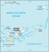
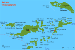
total: 151 km² note: comprises 16 inhabited and more than 20 uninhabited islands; includes the islands of Tortola Tortola Tortola is the largest and most populated of the British Virgin Islands, a group of islands that form part of the archipelago of the Virgin Islands. Local tradition recounts that Christopher Columbus named it Tortola, meaning "land of the Turtle Dove". Columbus named the island Santa Ana... , Anegada Anegada Anegada is the northernmost of the British Virgin Islands, a group of islands which form part of the archipelago of the Virgin Islands. It lies approximately north of Virgin Gorda. Anegada is the only inhabited British Virgin Island formed from coral and limestone, rather than being of volcanic... , Virgin Gorda Virgin Gorda Virgin Gorda is the third-largest and second most populous of the British Virgin Islands . Located at approximately 18 degrees, 48 minutes North, and 64 degrees, 30 minutes West, it covers an area of about... and Jost van Dyke Jost Van Dyke At roughly 8 square kilometers, and about 3 square miles Jost Van Dyke is the smallest of the four main islands of the British Virgin Islands, the northern portion of the archipelago of the Virgin Islands, located in the Atlantic Ocean and Caribbean Sea. Jost Van Dyke lies about 8 km to the... water: 0 km² land: 151 km² |
|
about 0.9 times the size of Washington, DC |
|
0 km |
|
80 km |
|
territorial sea: 3 nmi (5.6 km; 3.5 mi) exclusive fishing zone: 200 nmi (370.4 km; 230.2 mi) |
|
subtropical; humid; temperatures moderated by trade winds |
|
coral islands relatively flat; volcanic islands steep, hilly |
|
lowest point: Caribbean Sea Caribbean Sea The Caribbean Sea is a sea of the Atlantic Ocean located in the tropics of the Western hemisphere. It is bounded by Mexico and Central America to the west and southwest, to the north by the Greater Antilles, and to the east by the Lesser Antilles.... 0 m highest point: Mount Sage Mount Sage Mount Sage is a volcanic peak which is the highest point in the British Virgin Islands. It is located on the island of Tortola to the southwest of the island group's capital Road Town, and rises to a height of 530 m .... 521 m |
|
NEGL |
|
arable land: 20% permanent crops: 6.67% other: 73.33% (2005) |
|
n/a |
|
hurricanes and tropical storms (July to October) |
|
limited natural fresh water resources (except for a few seasonal streams and springs on Tortola Tortola Tortola is the largest and most populated of the British Virgin Islands, a group of islands that form part of the archipelago of the Virgin Islands. Local tradition recounts that Christopher Columbus named it Tortola, meaning "land of the Turtle Dove". Columbus named the island Santa Ana... , most of the islands' water supply comes from wells and rainwater catchments) |
|
strong ties to nearby US Virgin Islands and Puerto Rico Puerto Rico Puerto Rico , officially the Commonwealth of Puerto Rico , is an unincorporated territory of the United States, located in the northeastern Caribbean, east of the Dominican Republic and west of both the United States Virgin Islands and the British Virgin Islands.Puerto Rico comprises an... |
Climate
The British Virgin Islands enjoy a tropical climate, moderated by trade windTrade wind
The trade winds are the prevailing pattern of easterly surface winds found in the tropics, within the lower portion of the Earth's atmosphere, in the lower section of the troposphere near the Earth's equator...
s. Temperatures vary little throughout the year. In the capital, Road Town
Road Town
-See also:* Government House, the official residence of the Governor of the British Virgin Islands located in Road Town-External links:*****...
, typical daily maxima are around 32 °C (89.6 °F) in the summer and 29 °C (84.2 °F) in the winter. Typical daily minima are around 24 °C (75.2 °F) in the summer and 21 °C (69.8 °F) in the winter. Rainfall averages about 1150 mm (45.3 in) per year, higher in the hills and lower on the coast. Rainfall can be quite variable, but the wettest months on average are September to November and the driest months on average are February and March. Hurricanes occasionally hit the islands, with the hurricane season running from June to November.