

Geography of Vojvodina
Encyclopedia
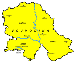
Vojvodina
Vojvodina, officially called Autonomous Province of Vojvodina is an autonomous province of Serbia. Its capital and largest city is Novi Sad...
is an autonomous region within Serbia
Serbia
Serbia , officially the Republic of Serbia , is a landlocked country located at the crossroads of Central and Southeast Europe, covering the southern part of the Carpathian basin and the central part of the Balkans...
located in the Pannonian plain, a region of central Europe. It shares borders with Romania
Romania
Romania is a country located at the crossroads of Central and Southeastern Europe, on the Lower Danube, within and outside the Carpathian arch, bordering on the Black Sea...
in the east, Hungary
Hungary
Hungary , officially the Republic of Hungary , is a landlocked country in Central Europe. It is situated in the Carpathian Basin and is bordered by Slovakia to the north, Ukraine and Romania to the east, Serbia and Croatia to the south, Slovenia to the southwest and Austria to the west. The...
in the north, Croatia
Croatia
Croatia , officially the Republic of Croatia , is a unitary democratic parliamentary republic in Europe at the crossroads of the Mitteleuropa, the Balkans, and the Mediterranean. Its capital and largest city is Zagreb. The country is divided into 20 counties and the city of Zagreb. Croatia covers ...
in the west, and Bosnia and Herzegovina
Bosnia and Herzegovina
Bosnia and Herzegovina , sometimes called Bosnia-Herzegovina or simply Bosnia, is a country in Southern Europe, on the Balkan Peninsula. Bordered by Croatia to the north, west and south, Serbia to the east, and Montenegro to the southeast, Bosnia and Herzegovina is almost landlocked, except for the...
in the southwest. The southern border is administrative line to Central Serbia
Central Serbia
Central Serbia , also referred to as Serbia proper , was the region of Serbia from 1945 to 2009. It included central parts of Serbia outside of the autonomous provinces of Kosovo and Vojvodina. The region of Central Serbia was not an administrative division of Serbia as such; it was under the...
.
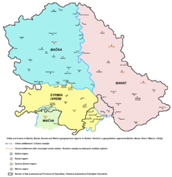
Geographical regions of Vojvodina
- BačkaBackaBačka is a geographical area within the Pannonian plain bordered by the river Danube to the west and south, and by the river Tisza to the east of which confluence is located near Titel...
- ŠajkaškaŠajkaškaŠajkaška is a geographical region in Serbia. It is southeastern part of Bačka, located in the Autonomous Province of Vojvodina. Territory of Šajkaška is divided among four municipalities: Titel, Žabalj, Novi Sad, and Srbobran. Historical center of Šajkaška is Titel.-Name:Name Šajkaška means "land...
- TelečkaTelecka (region)Telečka is a small geographical region in Serbia. It is located in north-western Bačka, in the Vojvodina province. There is also a village named Telečka, which is situated in this region....
- Gornji BregGornji Breg (region)Gornji Breg is a small geographical region in Serbia. It is located in north-eastern Bačka, in the Vojvodina province. There is also a village named Gornji Breg, which is situated in this region.-See also:*Bačka*Vojvodina...
- Šajkaška
- BanatBanatThe Banat is a geographical and historical region in Central Europe currently divided between three countries: the eastern part lies in western Romania , the western part in northeastern Serbia , and a small...
- Veliki RitVeliki Rit, BanatVeliki Rit is a small geographical area near Begej river in central-eastern Banat, Serbia....
- Gornje LivadeGornje Livade, BanatGornje Livade is a small geographical area in south-eastern Banat, Serbia. It is situated in eastern part of Deliblatska Peščara....
- Veliki Rit
- SremSyrmiaSyrmia is a fertile region of the Pannonian Plain in Europe, between the Danube and Sava rivers. It is divided between Serbia in the east and Croatia in the west....
- PodlužjePodlužjePodlužje is a small geographical region in Serbia. It is located in south-eastern Syrmia. The western part of Podlužje belong to the autonomous province of Vojvodina, and the eastern part belongs to the city of Belgrade...
- Podlužje
- MačvaMacvaMačva is a geographical region in Serbia, mostly situated in the northwest of Central Serbia. It is located in a fertile plain between the Sava and Drina rivers. The chief town of this region is Šabac. The modern Mačva District of Serbia is named after the region, although the region of Mačva...
- PodunavljePodunavljePodunavlje is the name of the Danube river basin parts located in Serbia and Croatia .-History:...
- PosavinaPosavinaPosavina is a Slavic name for the region of the Sava river basin in Croatia, Bosnia and Herzegovina, and Serbia that is adjacent or near the Sava river itself.-History:...
- PotisjePotisjePotisje is the name of the Tisa river basin parts located in Serbia, in the autonomous province of Vojvodina. The river Tisa flow between Banat and Bačka regions.-Municipalities in Potisje:Municipalities in Bačka:*Kanjiža*Senta*Ada*Bečej...
- PomorišjePomorišjePomorišje is a historical geographical region on the banks of the river Mureş that in the past has had a sizable ethnic Serb population. The region is mostly divided between Romania and Hungary, with small part of it in northern Serbia...
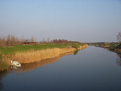
Rivers
- DanubeDanubeThe Danube is a river in the Central Europe and the Europe's second longest river after the Volga. It is classified as an international waterway....
- TisaTisáTisá is a village and municipality in Ústí nad Labem District in the Ústí nad Labem Region of the Czech Republic.The municipality covers an area of , and has a population of 786 ....
- Sava
- Begej
- TamišTamisA tamis is a kitchen utensil, shaped somewhat like a snare drum, that acts as a strainer, grater, or food mill. A tamis has a cylindrical edge, made of metal or wood, that supports a disc of fine metal, nylon, or horsehair mesh. To use one, the cook places the tamis above a bowl and adds the...
- KarašKarasKaras may refer to:Places* Karas Region, Namibia* Karaš River, a river in Serbia and Romania * Karas Island, an island in Sebakor Bay, West Papua, Indonesia* Karaś, Kuyavian-Pomeranian Voivodeship, a village in north-central Poland...
- Zlatica
- Nera
- BosutBosutThe Bosut is a river in eastern Croatia and northwestern Serbia, a 186 km long left tributary of the Sava river.- Croatia :...
- KrivajaKrivaja RiverThe Krivaja is a river in northern Serbia. With the length of 109 km it is the longest river that flows completely within the borders of Serbian province of Vojvodina.- Upper Course :...
- ČikCikThe Čik or Čiker is a river in northern Serbia...
- MostongaMostongaThe Mostonga is a river in northern Serbia, in Bačka region of the province of Vojvodina, a 70-km long left tributary to the Danube...
- PlazovićPlazovicThe Plazović or Kiđoš , is a river in southern Hungary and northern Serbia. It flows entirely within the Bačka region, and during its 129 km long course, on a section of only 15 km, it crosses the Hungarian-Serbian border eight times .-Hungary:The Kígyós originates in...
Canals
- Canal Danube-Tisa-Danube, and some larger canals part of DTD system:
- Begej canal
- Jegrička canalJegrickaThe Jegrička , is a river in northern Serbia, in the Bačka region of the Vojvodina province, a 65 km-long left tributary to the Tisa river, often erroneously referred to as the longest river in Vojvodina.The Jegrička originates south of the Pivnice village, in the central Bačka and flows in the...
- Jarčina canalJarcinaThe Jarčina is a system of rivers and canals in the Srem region of Vojvodina province of Serbia with a total length of 53 km, which empties into the Sava river. The system includes the Međeš river-Jarčina Galovica canal-Progarska Jarčina course.- Međeš :The upper section of the system is the...