
Geography of Saint Lucia
Encyclopedia
Saint Lucia
is one of many small land masses composing the insular group known as the Windward Islands
. Unlike large limestone areas such as Florida
, Cuba
, and the Yucatan Peninsula
, or the Bahamas, which is a small island group composed of coral and sand, St. Lucia is a typical Windward Island formation of volcanic rock that came into existence long after much of the region had already been formed.
St. Lucia's physical features are strikingly beautiful. Dominated by high peaks and rain forests in the interior, the 616 square kilometres (237.8 sq mi) island is known for the twin peaks of Gros Piton
and Petit Piton
on the southwestern coast, its soft sandy beaches, and its magnificent natural harbors. Mount Gimie
, the highest peak, is located in the central mountain range and rises to 958 metres (3,143 ft) above sea level, a contrast that is also evident in the abrupt climatic transition from coastal to inland areas. The steep terrain also accentuates the many rivers that flow from central St. Lucia to the Caribbean. Fertile land holdings, which support banana farming, are scattered throughout the island.
St. Lucia has a tropical, humid climate moderated by northeast trade winds that allow for pleasant year-round conditions. Mean annual temperatures range from 26 °C (78.8 °F) to 32 °C (89.6 °F) at sea level and drop to an average of 13 °C (55.4 °F) in the mountain peaks. The abundant annual rainfall accumulates to approximately 2000 millimetres (78.7 in), with most precipitation occurring during the June to December wet season. Hurricanes are the most severe climatic disturbance in this area and have been known to cause extensive damage. Although St. Lucia has historically been spared from serious hurricane destruction, Hurricane Allen
decimated the agricultural sector and claimed nine lives in 1980.
, an island between the Caribbean Sea
and North Atlantic Ocean, north of Trinidad and Tobago
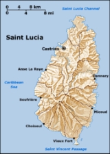
. The capital city of Saint Lucia is Castries
, where about one third of the population lives. Major towns include Gros Islet
, Soufrière
and Vieux Fort.
29 °C (84.2 °F), and average nighttime temperatures are around 18 °C (64.4 °F). Average annual rainfall ranges from 1300 mm (51.2 in) on the coast to 3810 mm (150 in) in the mountain rainforests.
s (pumice
), mineral spring
s, geothermal potential.
The island was severely affected by Hurricane Allen
in 1980, causing tourism to drop, but Saint Lucia has generally had fewer hurricanes than most other caribbean islands.
Biodiversity
, Climate Change
, Desertification
, Endangered Species
, Environmental Modification, Hazardous Wastes, Law of the Sea
, Marine Dumping, Ozone Layer Protection, Whaling
, Climate Change-Kyoto Protocol
Saint Lucia
Saint Lucia is an island country in the eastern Caribbean Sea on the boundary with the Atlantic Ocean. Part of the Lesser Antilles, it is located north/northeast of the island of Saint Vincent, northwest of Barbados and south of Martinique. It covers a land area of 620 km2 and has an...
is one of many small land masses composing the insular group known as the Windward Islands
Windward Islands
The Windward Islands are the southern islands of the Lesser Antilles, within the West Indies.-Name and geography:The Windward Islands are called such because they were more windward to sailing ships arriving in the New World than the Leeward Islands, given that the prevailing trade winds in the...
. Unlike large limestone areas such as Florida
Florida
Florida is a state in the southeastern United States, located on the nation's Atlantic and Gulf coasts. It is bordered to the west by the Gulf of Mexico, to the north by Alabama and Georgia and to the east by the Atlantic Ocean. With a population of 18,801,310 as measured by the 2010 census, it...
, Cuba
Cuba
The Republic of Cuba is an island nation in the Caribbean. The nation of Cuba consists of the main island of Cuba, the Isla de la Juventud, and several archipelagos. Havana is the largest city in Cuba and the country's capital. Santiago de Cuba is the second largest city...
, and the Yucatan Peninsula
Yucatán Peninsula
The Yucatán Peninsula, in southeastern Mexico, separates the Caribbean Sea from the Gulf of Mexico, with the northern coastline on the Yucatán Channel...
, or the Bahamas, which is a small island group composed of coral and sand, St. Lucia is a typical Windward Island formation of volcanic rock that came into existence long after much of the region had already been formed.
St. Lucia's physical features are strikingly beautiful. Dominated by high peaks and rain forests in the interior, the 616 square kilometres (237.8 sq mi) island is known for the twin peaks of Gros Piton
Gros Piton
Gros Piton is one of two mountains south of the town Soufrière in the southwest of Saint Lucia. Lying at the southern end of Pitons Bay, it rises to a height of 786 m . It is the second highest peak on Saint Lucia, after Mount Gimie....
and Petit Piton
Petit Piton
Petit Piton is one of two mountains overlooking Soufrière Bay in the southwest of Saint Lucia. Petit Piton lies towards the middle of the bay, south of the town of Soufrière and north of the larger mountain, Gros Piton, to which it is linked by the Piton Mitan Ridge. Petit Piton rises to a height...
on the southwestern coast, its soft sandy beaches, and its magnificent natural harbors. Mount Gimie
Mount Gimie
Mount Gimie is the tallest mountain on the island of St. Lucia. The mountain's peak reaches 950 m . It is of volcanic origin and is covered by lush tropical rainforest....
, the highest peak, is located in the central mountain range and rises to 958 metres (3,143 ft) above sea level, a contrast that is also evident in the abrupt climatic transition from coastal to inland areas. The steep terrain also accentuates the many rivers that flow from central St. Lucia to the Caribbean. Fertile land holdings, which support banana farming, are scattered throughout the island.
St. Lucia has a tropical, humid climate moderated by northeast trade winds that allow for pleasant year-round conditions. Mean annual temperatures range from 26 °C (78.8 °F) to 32 °C (89.6 °F) at sea level and drop to an average of 13 °C (55.4 °F) in the mountain peaks. The abundant annual rainfall accumulates to approximately 2000 millimetres (78.7 in), with most precipitation occurring during the June to December wet season. Hurricanes are the most severe climatic disturbance in this area and have been known to cause extensive damage. Although St. Lucia has historically been spared from serious hurricane destruction, Hurricane Allen
Hurricane Allen
Hurricane Allen was the first and strongest hurricane of the 1980 Atlantic hurricane season. It was one of the strongest hurricanes in recorded history, one of the few hurricanes to reach Category 5 status on the Saffir-Simpson Hurricane Scale on three separate occasions, and spent more time...
decimated the agricultural sector and claimed nine lives in 1980.
Location
Saint Lucia is in the CaribbeanCaribbean
The Caribbean is a crescent-shaped group of islands more than 2,000 miles long separating the Gulf of Mexico and the Caribbean Sea, to the west and south, from the Atlantic Ocean, to the east and north...
, an island between the Caribbean Sea
Caribbean Sea
The Caribbean Sea is a sea of the Atlantic Ocean located in the tropics of the Western hemisphere. It is bounded by Mexico and Central America to the west and southwest, to the north by the Greater Antilles, and to the east by the Lesser Antilles....
and North Atlantic Ocean, north of Trinidad and Tobago
Trinidad and Tobago
Trinidad and Tobago officially the Republic of Trinidad and Tobago is an archipelagic state in the southern Caribbean, lying just off the coast of northeastern Venezuela and south of Grenada in the Lesser Antilles...
. The capital city of Saint Lucia is Castries
Castries
Castries , population 10,634, aggl. 37,963 , is the capital city of Saint Lucia, a country in the Caribbean. The district with the same name had a population of 61,341 in 2001-05-22, and stretches over an area of ....
, where about one third of the population lives. Major towns include Gros Islet
Gros Islet
Gros Islet is a community located near the northern tip of the island country of Saint Lucia. Originally a quiet fishing village, it has gone on to become one of the more popular tourist destinations in the country....
, Soufrière
Soufrière
-Towns and villages:*Soufrière, Dominica, a village on the southwest coast of Dominica in the Caribbean.*Petit Soufrière, Dominica, a village on the east coast of Dominica.*Soufrière, a town in Saint Lucia in the Caribbean.-Landforms:...
and Vieux Fort.
Measurements
- total area: 616 km²
- length: 43.5 km
- width: 22.5 km
- comparative area: The same as TorontoTorontoToronto is the provincial capital of Ontario and the largest city in Canada. It is located in Southern Ontario on the northwestern shore of Lake Ontario. A relatively modern city, Toronto's history dates back to the late-18th century, when its land was first purchased by the British monarchy from...
or 3.5 times the size of Washington, DC - Land boundaries: 0 km
- Coastline: 158 km
Maritime claims
- contiguous zone: 24 nmi (44.4 km; 27.6 mi)
- exclusive economic zone: 200 nmi (370.4 km; 230.2 mi)
- territorial sea: 12 nmi (22.2 km; 13.8 mi)
Climate
Saint Lucia is in the tropical zone, although its climate is moderated by northeast trade winds. Since it's fairly close to the equator, the temperature doesn't fluctuate much between winter and summer. The dry season is from December to June, and the rainy season is from June to November. Average daytime temperatures are around29 °C (84.2 °F), and average nighttime temperatures are around 18 °C (64.4 °F). Average annual rainfall ranges from 1300 mm (51.2 in) on the coast to 3810 mm (150 in) in the mountain rainforests.
Elevation extremes
- lowest point: Caribbean Sea 0 m
- highest point: Mount GimieMount GimieMount Gimie is the tallest mountain on the island of St. Lucia. The mountain's peak reaches 950 m . It is of volcanic origin and is covered by lush tropical rainforest....
950 m
Natural resources
Forests, sandy beaches mineralMineral
A mineral is a naturally occurring solid chemical substance formed through biogeochemical processes, having characteristic chemical composition, highly ordered atomic structure, and specific physical properties. By comparison, a rock is an aggregate of minerals and/or mineraloids and does not...
s (pumice
Pumice
Pumice is a textural term for a volcanic rock that is a solidified frothy lava typically created when super-heated, highly pressurized rock is violently ejected from a volcano. It can be formed when lava and water are mixed. This unusual formation is due to the simultaneous actions of rapid...
), mineral spring
Mineral spring
Mineral springs are naturally occurring springs that produce water containing minerals, or other dissolved substances, that alter its taste or give it a purported therapeutic value...
s, geothermal potential.
Land use
- Arable land: 8%
- permanent crops: 21%
- permanent pastures: 5%
- forests and woodland: 13%
- other: 53% (1993 est.)
- Irrigated land: 10 km² (4 sq mi) (1993 est.)
Quarters
The island of Saint Lucia is divided into 11 quarters:- Anse la Raye
- CanariesCanaries QuarterCanaries is located on the West Coast of Saint Lucia. It is a small fishing village and it is nestled along the West Coast road, between Anse La Raye and Soufriere, and there are scenic views from both the Northern and Southern approaches.Until the 1960s there was no road transport to the village...
- CastriesCastries QuarterCastries Quarter is one of eleven Quarters on the Caribbean island nation of Saint Lucia. According to the 2002 census, the population of the Quarter was 64,957, having shown a slow but steady increase over the past ten years. The capital of Saint Lucia, the city of Castries, is located in this...
- ChoiseulChoiseul QuarterChoiseul is a Quarter of the Caribbean island nation of Saint Lucia. Located on the southwestern side of the island, the quarter is home to 6,174 people, according to the 2002 census...
- Dennery
- Forest Reserve
- Gros IsletGros Islet QuarterGros Islet is the newest town in Saint Lucia, having been recently promoted from a village to a town. It is the location of the Beausejour Cricket Grounds where both One Day International and Test Cricket is played. Parts of the 2007 Cricket World Cup and 2010 ICC World Twenty20 where played there...
- LaborieLaborie QuarterLaborie is a Quarter – an administrative division inherited from the former French colonial regime – on the Caribbean island-nation of Saint Lucia.According to the 2002 census, the population of the Quarter was 7,414 people...
- MicoudMicoud QuarterMicoud is a Quarter on the Caribbean island nation of Saint Lucia, and also a village inside that Quarter. According to the 2002 census, the population of the Quarter was 16,143 people. The village of Micoud is located at .-Adjacent quarters:...
- Soufrière
- Vieux FortVieux Fort QuarterVieux Fort is located in the southern part of St. Lucia. It is the second-largest town on the island and is the home of St Lucia's international airport, Hewanorra International Airport....
Natural hazards
Hurricanes and volcanic activity.The island was severely affected by Hurricane Allen
Hurricane Allen
Hurricane Allen was the first and strongest hurricane of the 1980 Atlantic hurricane season. It was one of the strongest hurricanes in recorded history, one of the few hurricanes to reach Category 5 status on the Saffir-Simpson Hurricane Scale on three separate occasions, and spent more time...
in 1980, causing tourism to drop, but Saint Lucia has generally had fewer hurricanes than most other caribbean islands.
International agreements
party to:Biodiversity
Biodiversity
Biodiversity is the degree of variation of life forms within a given ecosystem, biome, or an entire planet. Biodiversity is a measure of the health of ecosystems. Biodiversity is in part a function of climate. In terrestrial habitats, tropical regions are typically rich whereas polar regions...
, Climate Change
United Nations Framework Convention on Climate Change
The United Nations Framework Convention on Climate Change is an international environmental treaty produced at the United Nations Conference on Environment and Development , informally known as the Earth Summit, held in Rio de Janeiro from June 3 to 14, 1992...
, Desertification
Desertification
Desertification is the degradation of land in drylands. Caused by a variety of factors, such as climate change and human activities, desertification is one of the most significant global environmental problems.-Definitions:...
, Endangered Species
Endangered species
An endangered species is a population of organisms which is at risk of becoming extinct because it is either few in numbers, or threatened by changing environmental or predation parameters...
, Environmental Modification, Hazardous Wastes, Law of the Sea
Law of the sea
Law of the sea may refer to:* United Nations Convention on the Law of the Sea* Admiralty law* The Custom of the Sea...
, Marine Dumping, Ozone Layer Protection, Whaling
Whaling
Whaling is the hunting of whales mainly for meat and oil. Its earliest forms date to at least 3000 BC. Various coastal communities have long histories of sustenance whaling and harvesting beached whales...
, Climate Change-Kyoto Protocol