

Geography of Cambodia
Encyclopedia
Cambodia
is a country in Southeastern Asia, bordering the Gulf of Thailand
, between Thailand
, Vietnam
, and Laos
. Its approximate geographical coordinates are 11°N 104°E. Its 2,572 km border is split among Vietnam (1,228 km), Thailand (803 km) and Laos (541 km), as well as 443 km of coastline. Cambodia covers 181,040 square kilometres in the southwestern part of the Indochina peninsula. It lies completely within the tropics; its southernmost points are only slightly more than 10° above the equator. Roughly square in shape, the country is bounded on the north by Thailand and by Laos, on the east and southeast by Vietnam, and on the west by the Gulf of Thailand and by Thailand. Much of the country's area consists of rolling plains. Dominant features are the large, almost centrally located, Tonle Sap
(Great Lake) and the Mekong River, which traverses the country from north to south and is the 12th longest river in the world.
The climate is monsoonal and has marked wet and dry seasons of relatively equal length. Both temperature and humidity generally are high throughout the year. Forest covers about two-thirds of the country, but it has been somewhat degraded in the more readily accessible areas by burning (a method called slash-and-burn agriculture), and by shifting agriculture.
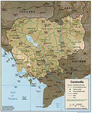
 Cambodia falls within several well-defined geographic regions. The largest part of the country, about 75 percent, consists of the Tonle Sap Basin and the Mekong Lowlands. To the southeast of this great basin is the Mekong Delta, which extends through Vietnam to the South China Sea
. The basin and delta regions are rimmed with mountain ranges to the southwest by the Cardamom Mountains
and the Elephant Range and to the north by the Dangrek Mountains
. Higher land to the northeast and to the east merges into the Central Highlands of southern Vietnam.
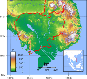
The Tonle Sap Basin-Mekong Lowlands region consists chiefly of plains with elevations generally of less than 100 meters. As the elevation increases, the terrain becomes more rolling and dissected.
The Cardamom Mountains in the southwest, oriented generally in a northwest-southeast direction, rise to more than 1,500 meters. The highest mountain in Cambodia--Phnom Aural
, at 1,771 meters—is in the eastern part of this range. The Elephant Range, an extension running toward the south and the southeast from the Cardamom Mountains, rises to elevations of between 500 and 1,000 meters. These two ranges are bordered on the west by a narrow coastal plain that contains Kampong Saom Bay, which faces the Gulf of Thailand
. This area was largely isolated until the opening of the port of Kampong Saom (formerly called Sihanoukville
) and the construction of a road and railroad connecting Kampong Saom, Kampot, Takev, and Phnom Penh
in the 1960s.
The Dangrek Mountains at the northern rim of the Tonle Sap Basin consist of a steep escarpment with an average elevation of about 500 meters, the highest points of which reach more than 700 meters. The escarpment faces southward and is the southern edge of the Korat Plateau in Thailand. The watershed along the escarpment marks the boundary between Thailand and Cambodia. The main road through a pass in the Dangrek Mountains at O Smach connects northwestern Cambodia with Thailand. Despite this road and those running through a few other passes, in general the escarpment impedes easy communication between the two countries. Between the western part of the Dangrek and the northern part of the Cardamom ranges, however, lies an extension of the Tonle Sap Basin that merges into lowlands in Thailand, which allows easy access from the border to Bangkok.
The Mekong Valley, which offers a communication route between Cambodia and Laos, separates the eastern end of the Dangrek Mountains and the northeastern highlands. To the southeast, the basin joins the Mekong Delta, which, extending into Vietnam, provides both water and land communications between the two countries.
s, which are known as tropical wet and dry because of the distinctly marked seasonal differences. The monsoonal airflows are caused by annual alternating high pressure and low pressure over the Central Asian landmass. In summer, moisture-laden air—the southwest monsoon—is drawn landward from the Indian Ocean. . The flow is reversed during the winter, and the northeast monsoon sends back dry air. The southwest monsoon brings the rainy season from mid-May to mid-September or to early October, and the northeast monsoon flow of drier and cooler air lasts from early November to March. The southern third of the country has a two-month dry season; the northern two-thirds, a four-month one. Short transitional periods, which are marked by some difference in humidity but by little change in temperature, intervene between the alternating seasons. Temperatures are fairly uniform throughout the Tonle Sap Basin area, with only small variations from the average annual mean of around 25 °C (77 °F). The maximum mean is about 28 °C (82.4 °F); the minimum mean, about 22.98 °C (73.4 °F). Maximum temperatures of higher than 32 °C (89.6 °F), however, are common and, just before the start of the rainy season, they may rise to more than 38 °C (100.4 °F). Minimum temperatures rarely fall below 10 °C (50 °F). January is the coolest month, and April is the warmest. Tropical cyclones that often devastate coastal Vietnam rarely cause damage in Cambodia.
The total annual rainfall average is between 1000 and 1500 mm (39.4 and 59.1 in), and the heaviest amounts fall in the southeast. Rainfall from April to September in the Tonle Sap Basin-Mekong Lowlands area averages 1300 to 1500 mm (51.2 to 59.1 in) annually, but the amount varies considerably from year to year. Rainfall around the basin increases with elevation. It is heaviest in the mountains along the coast in the southwest, which receive from 2500 millimetres (98.4 in) to more than 5000 millimetres (196.9 in) of precipitation annually as the southwest monsoon reaches the coast. This area of greatest rainfall, however, drains mostly to the sea; only a small quantity goes into the rivers flowing into the basin. The relative humidity is high at night throughout the year; usually it exceeds 90 percent. During the daytime in the dry season, humidity averages about 50 percent or slightly lower, but it may remain about 60 percent in the rainy period.
The Mekong River in Cambodia flows southward from the Cambodia-Laos border to a point below Kracheh city, where it turns west for about 50 kilometers and then turns southwest to Phnom Penh. Extensive rapids run above Kracheh city. From Kampong Cham the gradient slopes very gently, and inundation of areas along the river occurs at flood stage—June through November—through breaks in the natural levees that have built up along its course. At Phnom Penh four major water courses meet at a point called the Chattomukh (Four Faces). The Mekong River flows in from the northeast and the Tonle Sab—a river emanating from the Tonle Sap—flows in from the northwest. They divide into two parallel channels, the Mekong River proper and the Basak River, and flow independently through the delta areas of Cambodia and Vietnam to the South China Sea.
The flow of water into the Tonle Sap is seasonal. In September or in October, the flow of the Mekong River, fed by monsoon rains, increases to a point where its outlets through the delta cannot handle the enormous volume of water. At this point, the water pushes northward up the Tonle Sab and empties into the Tonle Sap, thereby increasing the size of the lake from about 2,590 square kilometers to about 24,605 square kilometers at the height of the flooding. After the Mekong's waters crest—when its downstream channels can handle the volume of water—the flow reverses, and water flows out of the engorged lake.
As the level of the Tonle Sap retreats, it deposits a new layer of sediment. The annual flooding, combined with poor drainage immediately around the lake, transforms the surrounding area into marshlands unusable for agricultural purposes during the dry season. The sediment deposited into the lake during the Mekong's flood stage appears to be greater than the quantity carried away later by the Tonle Sap River. Gradual silting of the lake would seem to be occurring; during low-water level, it is only about 1.5 meters deep, while at flood stage it is between 10 and 15 meters deep.
total:
181,035 km²
land:
176,520 km²
water:
4,520 km²
Maritime claims:
contiguous zone:
24 nmi (27.6 mi; 44.4 km)
continental shelf:
200 nmi (230.2 mi; 370.4 km)
exclusive economic zone:
200 nmi (230.2 mi; 370.4 km)
territorial sea:
12 nmi (13.8 mi; 22.2 km)
Elevation extremes:
lowest point:
Gulf of Thailand
0 m
highest point:
Phnum Aoral 1,810 m
oil
and natural gas
, timber
, gemstone
s, iron
ore, manganese
, phosphate
s, hydropower
potential
Land use:
arable land:
20.44%
permanent crops:
0.59%
other:
78.97% (2005)
Total renewable water resources:
476.1 km³ (114.22 cu mi) (1999)
Freshwater withdrawal (domestic/industrial/agricultural):
total: 4.08 km³ or 0.97884405510549 cu mi/yr (1%/0%/98%)
per capita: 290 km³ or 69.6 cu mi/yr (2000)
Irrigated land:
2700 km² (2003)
monsoonal rains (June to November); flooding; occasional droughts
Environment - current issues:
illegal logging
activities throughout the country and strip mining for gems in the western region along the border with Thailand
have resulted in habitat loss and declining biodiversity (in particular, destruction of mangrove swamps threatens natural fisheries); soil erosion; in rural areas, most of the population does not have access to potable water; declining fish stocks because of illegal fishing and overfishing
Environment - international agreements:
party to:
Biodiversity
, Climate Change
, Desertification
, Endangered Species
, Marine Life Conservation, Ship Pollution (MARPOL 73/78
), Tropical Timber 94, Wetlands
signed, but not ratified:
Law of the Sea
, Marine Dumping
Geography - note:
a land of paddies and forests dominated by the Mekong River and Tonle Sap
Lakes
Cambodia
Cambodia , officially known as the Kingdom of Cambodia, is a country located in the southern portion of the Indochina Peninsula in Southeast Asia...
is a country in Southeastern Asia, bordering the Gulf of Thailand
Gulf of Thailand
The Gulf of Thailand , also known in to Malays as Teluk Siam literally meant Gulf of Siam, is a shallow arm of the South China Sea.-Geography:...
, between Thailand
Thailand
Thailand , officially the Kingdom of Thailand , formerly known as Siam , is a country located at the centre of the Indochina peninsula and Southeast Asia. It is bordered to the north by Burma and Laos, to the east by Laos and Cambodia, to the south by the Gulf of Thailand and Malaysia, and to the...
, Vietnam
Vietnam
Vietnam – sometimes spelled Viet Nam , officially the Socialist Republic of Vietnam – is the easternmost country on the Indochina Peninsula in Southeast Asia. It is bordered by China to the north, Laos to the northwest, Cambodia to the southwest, and the South China Sea –...
, and Laos
Laos
Laos Lao: ສາທາລະນະລັດ ປະຊາທິປະໄຕ ປະຊາຊົນລາວ Sathalanalat Paxathipatai Paxaxon Lao, officially the Lao People's Democratic Republic, is a landlocked country in Southeast Asia, bordered by Burma and China to the northwest, Vietnam to the east, Cambodia to the south and Thailand to the west...
. Its approximate geographical coordinates are 11°N 104°E. Its 2,572 km border is split among Vietnam (1,228 km), Thailand (803 km) and Laos (541 km), as well as 443 km of coastline. Cambodia covers 181,040 square kilometres in the southwestern part of the Indochina peninsula. It lies completely within the tropics; its southernmost points are only slightly more than 10° above the equator. Roughly square in shape, the country is bounded on the north by Thailand and by Laos, on the east and southeast by Vietnam, and on the west by the Gulf of Thailand and by Thailand. Much of the country's area consists of rolling plains. Dominant features are the large, almost centrally located, Tonle Sap
Tonlé Sap
The Tonlé Sap is a combined lake and river system of major importance to Cambodia.The Tonlé Sap is the largest freshwater lake in South East Asia and is an ecological hot spot that was designated as a UNESCO biosphere in 1997....
(Great Lake) and the Mekong River, which traverses the country from north to south and is the 12th longest river in the world.
The climate is monsoonal and has marked wet and dry seasons of relatively equal length. Both temperature and humidity generally are high throughout the year. Forest covers about two-thirds of the country, but it has been somewhat degraded in the more readily accessible areas by burning (a method called slash-and-burn agriculture), and by shifting agriculture.
Topography
South China Sea
The South China Sea is a marginal sea that is part of the Pacific Ocean, encompassing an area from the Singapore and Malacca Straits to the Strait of Taiwan of around...
. The basin and delta regions are rimmed with mountain ranges to the southwest by the Cardamom Mountains
Cardamom Mountains
The Krâvanh Mountains, literally the "Cardamom Mountains" , is a mountain range in the south west of Cambodia, jutting into southeastern Thailand.-Location and description:...
and the Elephant Range and to the north by the Dangrek Mountains
Dângrêk Mountains
The Dângrêk Mountains , meaning "Carrying-Pole Mountains" in Khmer, is a mountain range forming a natural border between Cambodia and Thailand....
. Higher land to the northeast and to the east merges into the Central Highlands of southern Vietnam.
The Tonle Sap Basin-Mekong Lowlands region consists chiefly of plains with elevations generally of less than 100 meters. As the elevation increases, the terrain becomes more rolling and dissected.
The Cardamom Mountains in the southwest, oriented generally in a northwest-southeast direction, rise to more than 1,500 meters. The highest mountain in Cambodia--Phnom Aural
Phnom Aural
Phnom Aural is the tallest peak in Cambodia. It is 1,813 meters tall .It is in the eastern part of the Cardamom Mountains...
, at 1,771 meters—is in the eastern part of this range. The Elephant Range, an extension running toward the south and the southeast from the Cardamom Mountains, rises to elevations of between 500 and 1,000 meters. These two ranges are bordered on the west by a narrow coastal plain that contains Kampong Saom Bay, which faces the Gulf of Thailand
Gulf of Thailand
The Gulf of Thailand , also known in to Malays as Teluk Siam literally meant Gulf of Siam, is a shallow arm of the South China Sea.-Geography:...
. This area was largely isolated until the opening of the port of Kampong Saom (formerly called Sihanoukville
Sihanoukville
Sihanoukville , also known as Kampong Saom, is a province in southern Cambodia on the Gulf of Thailand. This port city is a growing Cambodian urban center, located southwest of the Cambodian capital, Phnom Penh. The province is named after King Father Norodom Sihanouk and grew up around the...
) and the construction of a road and railroad connecting Kampong Saom, Kampot, Takev, and Phnom Penh
Phnom Penh
Phnom Penh is the capital and largest city of Cambodia. Located on the banks of the Mekong River, Phnom Penh has been the national capital since the French colonized Cambodia, and has grown to become the nation's center of economic and industrial activities, as well as the center of security,...
in the 1960s.
The Dangrek Mountains at the northern rim of the Tonle Sap Basin consist of a steep escarpment with an average elevation of about 500 meters, the highest points of which reach more than 700 meters. The escarpment faces southward and is the southern edge of the Korat Plateau in Thailand. The watershed along the escarpment marks the boundary between Thailand and Cambodia. The main road through a pass in the Dangrek Mountains at O Smach connects northwestern Cambodia with Thailand. Despite this road and those running through a few other passes, in general the escarpment impedes easy communication between the two countries. Between the western part of the Dangrek and the northern part of the Cardamom ranges, however, lies an extension of the Tonle Sap Basin that merges into lowlands in Thailand, which allows easy access from the border to Bangkok.
The Mekong Valley, which offers a communication route between Cambodia and Laos, separates the eastern end of the Dangrek Mountains and the northeastern highlands. To the southeast, the basin joins the Mekong Delta, which, extending into Vietnam, provides both water and land communications between the two countries.
Climate
Cambodia's climate, like that of the rest of Southeast Asia is dominated by monsoonMonsoon
Monsoon is traditionally defined as a seasonal reversing wind accompanied by corresponding changes in precipitation, but is now used to describe seasonal changes in atmospheric circulation and precipitation associated with the asymmetric heating of land and sea...
s, which are known as tropical wet and dry because of the distinctly marked seasonal differences. The monsoonal airflows are caused by annual alternating high pressure and low pressure over the Central Asian landmass. In summer, moisture-laden air—the southwest monsoon—is drawn landward from the Indian Ocean. . The flow is reversed during the winter, and the northeast monsoon sends back dry air. The southwest monsoon brings the rainy season from mid-May to mid-September or to early October, and the northeast monsoon flow of drier and cooler air lasts from early November to March. The southern third of the country has a two-month dry season; the northern two-thirds, a four-month one. Short transitional periods, which are marked by some difference in humidity but by little change in temperature, intervene between the alternating seasons. Temperatures are fairly uniform throughout the Tonle Sap Basin area, with only small variations from the average annual mean of around 25 °C (77 °F). The maximum mean is about 28 °C (82.4 °F); the minimum mean, about 22.98 °C (73.4 °F). Maximum temperatures of higher than 32 °C (89.6 °F), however, are common and, just before the start of the rainy season, they may rise to more than 38 °C (100.4 °F). Minimum temperatures rarely fall below 10 °C (50 °F). January is the coolest month, and April is the warmest. Tropical cyclones that often devastate coastal Vietnam rarely cause damage in Cambodia.
The total annual rainfall average is between 1000 and 1500 mm (39.4 and 59.1 in), and the heaviest amounts fall in the southeast. Rainfall from April to September in the Tonle Sap Basin-Mekong Lowlands area averages 1300 to 1500 mm (51.2 to 59.1 in) annually, but the amount varies considerably from year to year. Rainfall around the basin increases with elevation. It is heaviest in the mountains along the coast in the southwest, which receive from 2500 millimetres (98.4 in) to more than 5000 millimetres (196.9 in) of precipitation annually as the southwest monsoon reaches the coast. This area of greatest rainfall, however, drains mostly to the sea; only a small quantity goes into the rivers flowing into the basin. The relative humidity is high at night throughout the year; usually it exceeds 90 percent. During the daytime in the dry season, humidity averages about 50 percent or slightly lower, but it may remain about 60 percent in the rainy period.
Drainage
Except for the smaller rivers in the southeast, most of the major rivers and river systems in Cambodia drain into the Tonle Sap or into the Mekong River. The Cardamom Mountains and Elephant Range form a separate drainage divide. To the east the rivers flow into the Tonle Sap, while on the west they flow into the Gulf of Thailand. Toward the southern end of the Elephant Mountains, however, because of the topography, some small rivers flow southward on the eastern side of the divide.The Mekong River in Cambodia flows southward from the Cambodia-Laos border to a point below Kracheh city, where it turns west for about 50 kilometers and then turns southwest to Phnom Penh. Extensive rapids run above Kracheh city. From Kampong Cham the gradient slopes very gently, and inundation of areas along the river occurs at flood stage—June through November—through breaks in the natural levees that have built up along its course. At Phnom Penh four major water courses meet at a point called the Chattomukh (Four Faces). The Mekong River flows in from the northeast and the Tonle Sab—a river emanating from the Tonle Sap—flows in from the northwest. They divide into two parallel channels, the Mekong River proper and the Basak River, and flow independently through the delta areas of Cambodia and Vietnam to the South China Sea.
The flow of water into the Tonle Sap is seasonal. In September or in October, the flow of the Mekong River, fed by monsoon rains, increases to a point where its outlets through the delta cannot handle the enormous volume of water. At this point, the water pushes northward up the Tonle Sab and empties into the Tonle Sap, thereby increasing the size of the lake from about 2,590 square kilometers to about 24,605 square kilometers at the height of the flooding. After the Mekong's waters crest—when its downstream channels can handle the volume of water—the flow reverses, and water flows out of the engorged lake.
As the level of the Tonle Sap retreats, it deposits a new layer of sediment. The annual flooding, combined with poor drainage immediately around the lake, transforms the surrounding area into marshlands unusable for agricultural purposes during the dry season. The sediment deposited into the lake during the Mekong's flood stage appears to be greater than the quantity carried away later by the Tonle Sap River. Gradual silting of the lake would seem to be occurring; during low-water level, it is only about 1.5 meters deep, while at flood stage it is between 10 and 15 meters deep.
Regional divisions
Cambodia's boundaries were for the most part based upon those recognized by France and by neighboring countries during the colonial period. The 800-kilometre boundary with Thailand, coincides with a natural feature, the watershed of the Dangrek Mountains, only in its northern sector. The 541-kilometer border with Laos and the 1,228-kilometer border with Vietnam result largely from French administrative decisions and do not follow major natural features. Border disputes have broken out in the past between Cambodia and Thailand as well as between Cambodia and Vietnam.Area and boundaries
Area:total:
181,035 km²
land:
176,520 km²
water:
4,520 km²
Maritime claims:
contiguous zone:
24 nmi (27.6 mi; 44.4 km)
continental shelf:
200 nmi (230.2 mi; 370.4 km)
exclusive economic zone:
200 nmi (230.2 mi; 370.4 km)
territorial sea:
12 nmi (13.8 mi; 22.2 km)
Elevation extremes:
lowest point:
Gulf of Thailand
Gulf of Thailand
The Gulf of Thailand , also known in to Malays as Teluk Siam literally meant Gulf of Siam, is a shallow arm of the South China Sea.-Geography:...
0 m
highest point:
Phnum Aoral 1,810 m
Resources and land use
Natural resources:oil
Petroleum
Petroleum or crude oil is a naturally occurring, flammable liquid consisting of a complex mixture of hydrocarbons of various molecular weights and other liquid organic compounds, that are found in geologic formations beneath the Earth's surface. Petroleum is recovered mostly through oil drilling...
and natural gas
Natural gas
Natural gas is a naturally occurring gas mixture consisting primarily of methane, typically with 0–20% higher hydrocarbons . It is found associated with other hydrocarbon fuel, in coal beds, as methane clathrates, and is an important fuel source and a major feedstock for fertilizers.Most natural...
, timber
Timber
Timber may refer to:* Timber, a term common in the United Kingdom and Australia for wood materials * Timber, Oregon, an unincorporated community in the U.S...
, gemstone
Gemstone
A gemstone or gem is a piece of mineral, which, in cut and polished form, is used to make jewelry or other adornments...
s, iron
Iron
Iron is a chemical element with the symbol Fe and atomic number 26. It is a metal in the first transition series. It is the most common element forming the planet Earth as a whole, forming much of Earth's outer and inner core. It is the fourth most common element in the Earth's crust...
ore, manganese
Manganese
Manganese is a chemical element, designated by the symbol Mn. It has the atomic number 25. It is found as a free element in nature , and in many minerals...
, phosphate
Phosphate
A phosphate, an inorganic chemical, is a salt of phosphoric acid. In organic chemistry, a phosphate, or organophosphate, is an ester of phosphoric acid. Organic phosphates are important in biochemistry and biogeochemistry or ecology. Inorganic phosphates are mined to obtain phosphorus for use in...
s, hydropower
Hydropower
Hydropower, hydraulic power, hydrokinetic power or water power is power that is derived from the force or energy of falling water, which may be harnessed for useful purposes. Since ancient times, hydropower has been used for irrigation and the operation of various mechanical devices, such as...
potential
Land use:
arable land:
20.44%
permanent crops:
0.59%
other:
78.97% (2005)
Total renewable water resources:
476.1 km³ (114.22 cu mi) (1999)
Freshwater withdrawal (domestic/industrial/agricultural):
total: 4.08 km³ or 0.97884405510549 cu mi/yr (1%/0%/98%)
per capita: 290 km³ or 69.6 cu mi/yr (2000)
Irrigated land:
2700 km² (2003)
Environmental concerns
Natural hazards:monsoonal rains (June to November); flooding; occasional droughts
Environment - current issues:
illegal logging
Logging
Logging is the cutting, skidding, on-site processing, and loading of trees or logs onto trucks.In forestry, the term logging is sometimes used in a narrow sense concerning the logistics of moving wood from the stump to somewhere outside the forest, usually a sawmill or a lumber yard...
activities throughout the country and strip mining for gems in the western region along the border with Thailand
Thailand
Thailand , officially the Kingdom of Thailand , formerly known as Siam , is a country located at the centre of the Indochina peninsula and Southeast Asia. It is bordered to the north by Burma and Laos, to the east by Laos and Cambodia, to the south by the Gulf of Thailand and Malaysia, and to the...
have resulted in habitat loss and declining biodiversity (in particular, destruction of mangrove swamps threatens natural fisheries); soil erosion; in rural areas, most of the population does not have access to potable water; declining fish stocks because of illegal fishing and overfishing
Environment - international agreements:
party to:
Biodiversity
Biodiversity
Biodiversity is the degree of variation of life forms within a given ecosystem, biome, or an entire planet. Biodiversity is a measure of the health of ecosystems. Biodiversity is in part a function of climate. In terrestrial habitats, tropical regions are typically rich whereas polar regions...
, Climate Change
United Nations Framework Convention on Climate Change
The United Nations Framework Convention on Climate Change is an international environmental treaty produced at the United Nations Conference on Environment and Development , informally known as the Earth Summit, held in Rio de Janeiro from June 3 to 14, 1992...
, Desertification
Desertification
Desertification is the degradation of land in drylands. Caused by a variety of factors, such as climate change and human activities, desertification is one of the most significant global environmental problems.-Definitions:...
, Endangered Species
Endangered species
An endangered species is a population of organisms which is at risk of becoming extinct because it is either few in numbers, or threatened by changing environmental or predation parameters...
, Marine Life Conservation, Ship Pollution (MARPOL 73/78
MARPOL 73/78
Marpol 73/78 is the International Convention for the Prevention of Pollution From Ships, 1973 as modified by the Protocol of 1978....
), Tropical Timber 94, Wetlands
signed, but not ratified:
Law of the Sea
Law of the sea
Law of the sea may refer to:* United Nations Convention on the Law of the Sea* Admiralty law* The Custom of the Sea...
, Marine Dumping
Geography - note:
a land of paddies and forests dominated by the Mekong River and Tonle Sap
Lakes
- Tonlé Sap Lake