
Geography of Aruba
Encyclopedia
Aruba
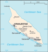
Aruba is a 33 km-long island of the Lesser Antilles in the southern Caribbean Sea, located 27 km north of the coast of Venezuela and 130 km east of Guajira Peninsula...
is a small Caribbean
Caribbean
The Caribbean is a crescent-shaped group of islands more than 2,000 miles long separating the Gulf of Mexico and the Caribbean Sea, to the west and south, from the Atlantic Ocean, to the east and north...
island (54 sq mi (140 km²)) about the size of Washington, D.C.
Washington, D.C.
Washington, D.C., formally the District of Columbia and commonly referred to as Washington, "the District", or simply D.C., is the capital of the United States. On July 16, 1790, the United States Congress approved the creation of a permanent national capital as permitted by the U.S. Constitution....
, located 25 km north of the coast of Venezuela
Venezuela
Venezuela , officially called the Bolivarian Republic of Venezuela , is a tropical country on the northern coast of South America. It borders Colombia to the west, Guyana to the east, and Brazil to the south...
and 68 km northwest of Curaçao
Curaçao
Curaçao is an island in the southern Caribbean Sea, off the Venezuelan coast. The Country of Curaçao , which includes the main island plus the small, uninhabited island of Klein Curaçao , is a constituent country of the Kingdom of the Netherlands...
, the largest island of the Kingdom of the Netherlands
Kingdom of the Netherlands
The Kingdom of the Netherlands is a sovereign state and constitutional monarchy with territory in Western Europe and in the Caribbean. The four parts of the Kingdom—Aruba, Curaçao, the Netherlands, and Sint Maarten—are referred to as "countries", and participate on a basis of equality...
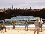
. Aruba’s terrain is mostly flat with a few hills. There is little in the way of vegetation or outstanding physical features and no inland water. Aruba’s best-known geographical feature is its white-sand beaches, which are the basis of an active tourism
Tourism
Tourism is travel for recreational, leisure or business purposes. The World Tourism Organization defines tourists as people "traveling to and staying in places outside their usual environment for not more than one consecutive year for leisure, business and other purposes".Tourism has become a...
industry that is the mainstay of the island’s economy. Aruba is situated on the Caribbean Tectonic Plate
Caribbean Plate
The Caribbean Plate is a mostly oceanic tectonic plate underlying Central America and the Caribbean Sea off the north coast of South America....
. The island is made up of limestone
Limestone
Limestone is a sedimentary rock composed largely of the minerals calcite and aragonite, which are different crystal forms of calcium carbonate . Many limestones are composed from skeletal fragments of marine organisms such as coral or foraminifera....
-capped hills and ridges, with cliffs on the northern and northeastern coasts and coral reef
Coral reef
Coral reefs are underwater structures made from calcium carbonate secreted by corals. Coral reefs are colonies of tiny living animals found in marine waters that contain few nutrients. Most coral reefs are built from stony corals, which in turn consist of polyps that cluster in groups. The polyps...
s on the southern coast.
Mountains and Hills
Aruba’s terrain is almost entirely flat. The highest elevation, so-called Mount JamanotaMount Jamanota
Mount Jamanota is the highest point on the island of Aruba and is visible from the entire island. Wild goats and donkeys roam free on the mountain. The panorama from its summit includes Frenchman's Pass on the south coast, where Indians defended their island against the French. The area is known...
, is only 188 m above sea level. Rock formations characterize the interior of the island.
The Coast and Beaches
Aruba has three deepwater harbors located at OranjestadOranjestad, Aruba
Oranjestad is the capital and largest city of Aruba, which is in the Caribbean north of Venezuela. Oranjestad is located on the southern coast near the western end of the island country...
, Barcadera, and San Nicolaas (Sint Nicolaas). The coastal area is known for its white-sand beaches and the calm waters surrounding Aruba are clear, making it a popular tourist destination.
Temperature
Aruba’s tropical marine climate varies little seasonally, with an average annual temperature of 27 °C (80.6 °F), varying from about 26 °C (78.8 °F) in January to 29 °C (84.2 °F) in July.Rainfall
Most rain brought by the prevailing easterly winds of the region falls on the Windward IslandsWindward Islands
The Windward Islands are the southern islands of the Lesser Antilles, within the West Indies.-Name and geography:The Windward Islands are called such because they were more windward to sailing ships arriving in the New World than the Leeward Islands, given that the prevailing trade winds in the...
of the Lesser Antilles
Lesser Antilles
The Lesser Antilles are a long, partly volcanic island arc in the Western Hemisphere. Most of its islands form the eastern boundary of the Caribbean Sea with the Atlantic Ocean, with the remainder located in the southern Caribbean just north of South America...
, leaving Aruba with a very dry climate. Rainfall
averages 510 mm (20.1 in) or less annually, and the island’s residents rely on one of the world’s largest desalination plants for most of their drinking water. The rainy season occurs between October and December.
Statistics
Location:- Caribbean, island in the Caribbean SeaCaribbean SeaThe Caribbean Sea is a sea of the Atlantic Ocean located in the tropics of the Western hemisphere. It is bounded by Mexico and Central America to the west and southwest, to the north by the Greater Antilles, and to the east by the Lesser Antilles....
, north of VenezuelaVenezuelaVenezuela , officially called the Bolivarian Republic of Venezuela , is a tropical country on the northern coast of South America. It borders Colombia to the west, Guyana to the east, and Brazil to the south...
Geographic coordinates:
- 12°30′N 69°58′W
Map references:
- Central AmericaCentral AmericaCentral America is the central geographic region of the Americas. It is the southernmost, isthmian portion of the North American continent, which connects with South America on the southeast. When considered part of the unified continental model, it is considered a subcontinent...
and the Caribbean
Area:
- Total: 193 km²
- Land: 193 km²
- Water: 0 km²
country comparison to the world: 108
Area comparative:
- slightly larger than Washington DC
Land boundaries:
- 0 km
Coastline:
- 68.5 km
Maritime claims:
The "Rijkswet" of December 12, 1985, for the maritime boundaries between The Netherlands Antilles and Aruba, and the Maritime Boundaries Treaty signed March 31, 1978, between the Republic of Venezuela and the Kingdom of the Netherlands, introduced December 12, 1978, and valid for Aruba since January 1, 1986.
- Territorial sea: 12 nmi (22.2 km; 13.8 mi)
Climate:
- Tropical marine; little seasonal temperature variation
Terrain:
- Flat with a few hills; scant vegetation
Elevation extremes:
- Lowest point: Caribbean Sea 0 m
- Highest point: Mount JamanotaMount JamanotaMount Jamanota is the highest point on the island of Aruba and is visible from the entire island. Wild goats and donkeys roam free on the mountain. The panorama from its summit includes Frenchman's Pass on the south coast, where Indians defended their island against the French. The area is known...
188 m - Best known: HooibergHooibergHooiberg is a 168 m high volcanic formation on the island of Aruba. It is located almost in the center of the island and can be seen from virtually anywhere on the island....
165 m (541 ft)
Natural resources:
- Negligible; white sandy beaches
Land use:
- Arable land: 10.53% (including aloe 0.01%)
- Permanent crops: 0%
- Other: 89.47% (2005)
Irrigated land:
- 0.01 km² (1998 est.)
Natural hazards:
- While Aruba barely lies within the Caribbean hurricane belt, storms rarely if ever pass over the island.
Environment--current issues:
Geography-note:
- A flat, riverless island renowned for its white sand beaches; its tropical climate is moderated by constant trade winds from the Atlantic OceanAtlantic OceanThe Atlantic Ocean is the second-largest of the world's oceanic divisions. With a total area of about , it covers approximately 20% of the Earth's surface and about 26% of its water surface area...
; the temperature is almost constant at about 27 degrees Celsius.
External links
- Map of Aruba
- Maps of Aruba (including island map, and detail maps of Oranjestad and San Nicolas)