
Gardiners Creek Trail
Encyclopedia
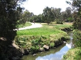
The Gardiners Creek Trail is a shared use path for cyclists
and pedestrian
s, which follows Gardiners Creek
through the eastern suburbs of Melbourne
, Victoria
, Australia
.
Bicycle Victoria
is campaigning for a connection between Winton Road and Warrigal Road, to complete the gap in the trail at this point. It is proposed that the path would continue along the creek parallel to the Malvern Public Golf Course, spanning the gap from Winton Road to Warrigal Road. The Solway Street footbridge would be replaced at a point 10 m further to the east from the original.
The length of the gap was exacerbated for over a year, following the closure of the Solway Street footbridge due to storm damage, sometime before April 2006. The old bridge was shored up and reopened in June 2007. A replacement bridge has been under discussion since at least 2003. As of April 2008 it remains under discussion.
 The path begins as a branch of the Main Yarra Trail
, opposite St Kevin's College and Scotch College
, close to Kooyong railway station (on the Glen Waverley line); between the suburbs of Toorak
, Hawthorn
, and Kooyong
. The path snakes along Gardiners Creek, near the Monash Freeway
. Its also goes past Solway Primary School.
Near East Malvern railway station it crosses Winton Road. At this point, riders can continue straight ahead to East Malvern railway station to pick up the Scotchmans Creek Trail
and East Malvern Station to Centre Road Trail.
Heading down the detour route of Winton Road, Glen Road and Solway Street, since the Solway Street Bridge was washed away by flood waters in February 2011, and travel up Ryburne Road. The very southern end of the Anniversary Trail
appears on the left near the end of Ryburne Rd. Using the Anniversary Trail
continue to Alamein station. At that point another trails splits of and continues via Markham Reserve to Warrigal Road. An underpass of Warrigal Road, completed in August 2011, now allows easy access to the path on the east side of Warrigal Road, at the south side of the creek.
The path continues northeast through Ashwood Reserve to High Street Road, and then north (near Ashwood College) through Gardiners Reserve to Highbury Road. Across a nearby pedestrian crossing, the path continues north to the south of the intersection of McIntyre Street, Elgar Road, and Burwood Highway
(near Presbyterian Ladies' College
).
From Burwood Highway (near the Burwood Campus of Deakin University
, east of Elgar Road), the path continues to the north-east along Gardiners Creek to Station Street, near the Box Hill Golf Club.
Once at Station Street cross the new pedestrian crossing installed in 2007/2008. At Station Street one has the choice of continuing along the Gardiners Creek Trail or diverting to the Wurundjeri Walk Trail
.
Go left (north) up Old Station Street, passing immediately by the golf club entrance. Turn right at the very quiet and dead end part of Riversdale Road. The trail resumes at the end of Riversdale Road.
Turning right after the pedestrian crossing leads to Boardman Close. The far end of the close leads to the Wurundjeri Walk Trail
. The trail signs in the vicinity of the pedestrian crossing are non existent and to avoid getting lost, great care needs to be taken:
The Gardiners Creek Trail continues north east, via a path on the north side of the Box Hill Golf Course, to the intersection of Canterbury and Middleborough Roads in Box Hill South. It follows Middleborough Road through R.H.L. Sparks Reserve to Albion Road, the path continues east along Blacks Walk reserve and the Blackburn Creeklands reserve to Blackburn Road.
Cross Blackburn Road and use either Alandale Road or Jeffrey Street to enter Blackburn Lake Sanctuary
. North of here is the Blackburn Station
and Blackburn
shopping centre.
.
/Yarra River Trail at the Yarra River. Centrally it connects with the Anniversary Trail
, which runs along the Alamein railway line and to the nearby Scotchmans Creek Trail
and East Malvern Station to Centre Road Trail at East Malvern railway station. At Warrigal Road it connects to the Waverley Rail Trail
. Towards the eastern most end it meets the Wurundjeri Walk Trail
in Blackburn South, and finally ends at Blacks Walk in Blackburn
and Blackburn Lake Sanctuary
.
The Ferndale Park Trail
acts as a short cut to the Anniversary Trail
.
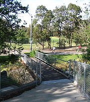
Note the footbridge over the Monash Freeway
was reopened on the 20th August 2009.
West end at 37.833995°S 145.023586°E.
East end at 37.825926°S 145.166615°E.
Cycling
Cycling, also called bicycling or biking, is the use of bicycles for transport, recreation, or for sport. Persons engaged in cycling are cyclists or bicyclists...
and pedestrian
Pedestrian
A pedestrian is a person traveling on foot, whether walking or running. In some communities, those traveling using roller skates or skateboards are also considered to be pedestrians. In modern times, the term mostly refers to someone walking on a road or footpath, but this was not the case...
s, which follows Gardiners Creek
Gardiners Creek
Gardiners Creek, originally known as Kooyongkoot Creek, is a waterway in the eastern suburbs of Melbourne, and part of the Yarra River catchment....
through the eastern suburbs of Melbourne
Melbourne
Melbourne is the capital and most populous city in the state of Victoria, and the second most populous city in Australia. The Melbourne City Centre is the hub of the greater metropolitan area and the Census statistical division—of which "Melbourne" is the common name. As of June 2009, the greater...
, Victoria
Victoria (Australia)
Victoria is the second most populous state in Australia. Geographically the smallest mainland state, Victoria is bordered by New South Wales, South Australia, and Tasmania on Boundary Islet to the north, west and south respectively....
, Australia
Australia
Australia , officially the Commonwealth of Australia, is a country in the Southern Hemisphere comprising the mainland of the Australian continent, the island of Tasmania, and numerous smaller islands in the Indian and Pacific Oceans. It is the world's sixth-largest country by total area...
.
Bicycle Victoria
Bicycle Victoria
Bicycle Network Victoria is a community-based not-for-profit organisation, one of the largest cycling membership organisations in the world , whose mission is to get More People Cycling More Often. The name was changed from Bicycle Victoria to Bicycle Network Victoria in July 2011...
is campaigning for a connection between Winton Road and Warrigal Road, to complete the gap in the trail at this point. It is proposed that the path would continue along the creek parallel to the Malvern Public Golf Course, spanning the gap from Winton Road to Warrigal Road. The Solway Street footbridge would be replaced at a point 10 m further to the east from the original.
The length of the gap was exacerbated for over a year, following the closure of the Solway Street footbridge due to storm damage, sometime before April 2006. The old bridge was shored up and reopened in June 2007. A replacement bridge has been under discussion since at least 2003. As of April 2008 it remains under discussion.
Following the Path
Main Yarra Trail
The Yarra Trail is a shared use path for cyclists and pedestrians, which follows the Yarra River through the north eastern suburbs of Melbourne, Victoria, Australia....
, opposite St Kevin's College and Scotch College
Scotch College, Melbourne
Scotch College, Melbourne is an independent, Presbyterian, day and boarding school for boys, located in Hawthorn, an inner-eastern suburb of Melbourne, Victoria, Australia....
, close to Kooyong railway station (on the Glen Waverley line); between the suburbs of Toorak
Toorak, Victoria
Toorak is a suburb of Melbourne, Victoria, Australia, 5 km south-east from Melbourne's central business district located on a rise on the south side of a bend in the Yarra River. Its Local Government Area is the City of Stonnington...
, Hawthorn
Hawthorn, Victoria
Hawthorn is a suburb in Melbourne, Victoria, Australia, east from Melbourne's central business district. Its Local Government Area is the City of Boroondara...
, and Kooyong
Kooyong, Victoria
Kooyong is a suburb in Melbourne, Victoria, Australia, south-east from Melbourne's central business district. Its Local Government Area is the City of Stonnington. At the 2006 Census, Kooyong had a population of 781....
. The path snakes along Gardiners Creek, near the Monash Freeway
Monash Freeway
Monash Freeway is an urban freeway in Victoria, Australia linking Melbourne's CBD to its southeastern suburbs and the Gippsland region. The entire stretch of the Monash Freeway bears the designation...
. Its also goes past Solway Primary School.
Near East Malvern railway station it crosses Winton Road. At this point, riders can continue straight ahead to East Malvern railway station to pick up the Scotchmans Creek Trail
Scotchmans Creek Trail
The Scotchmans Creek Trail is a shared use path for cyclists and pedestrians, which follows Scotchmans Creek through the eastern suburbs of Melbourne, Victoria, Australia....
and East Malvern Station to Centre Road Trail.
Heading down the detour route of Winton Road, Glen Road and Solway Street, since the Solway Street Bridge was washed away by flood waters in February 2011, and travel up Ryburne Road. The very southern end of the Anniversary Trail
Outer Circle Trail
The Outer Circle Trail, also known as the Anniversary Trail, Anniversary Outer Circle Trail, or even the Outer Circle Anniversary Trail, is a shared use path for cyclists and pedestrians, which partly follows the Alamein Line through the inner eastern suburbs of Melbourne, Victoria, Australia.The...
appears on the left near the end of Ryburne Rd. Using the Anniversary Trail
Outer Circle Trail
The Outer Circle Trail, also known as the Anniversary Trail, Anniversary Outer Circle Trail, or even the Outer Circle Anniversary Trail, is a shared use path for cyclists and pedestrians, which partly follows the Alamein Line through the inner eastern suburbs of Melbourne, Victoria, Australia.The...
continue to Alamein station. At that point another trails splits of and continues via Markham Reserve to Warrigal Road. An underpass of Warrigal Road, completed in August 2011, now allows easy access to the path on the east side of Warrigal Road, at the south side of the creek.
The path continues northeast through Ashwood Reserve to High Street Road, and then north (near Ashwood College) through Gardiners Reserve to Highbury Road. Across a nearby pedestrian crossing, the path continues north to the south of the intersection of McIntyre Street, Elgar Road, and Burwood Highway
Burwood Highway
Burwood Highway is a major transportation link with Melbourne's eastern suburbs. It begins in the suburb of Kooyong, Melbourne at the junction of the Monash Freeway as Toorak Road between Monash Freeway and Warrigal Road, and finishes in Belgrave, Victoria in the Dandenong Ranges...
(near Presbyterian Ladies' College
Presbyterian Ladies' College, Melbourne
Presbyterian Ladies' College, Melbourne , is an independent,private, Presbyterian, day and boarding school predominantly for girls, located in Burwood, an eastern suburb of Melbourne, Victoria, Australia....
).
From Burwood Highway (near the Burwood Campus of Deakin University
Deakin University
Deakin University is an Australian public university with nearly 40,000 higher education students in 2010. It receives more than A$600 million in operating revenue annually, and controls more than A$1.3 billion in assets. It received more than A$35 million in research income in 2009 and had 835...
, east of Elgar Road), the path continues to the north-east along Gardiners Creek to Station Street, near the Box Hill Golf Club.
Once at Station Street cross the new pedestrian crossing installed in 2007/2008. At Station Street one has the choice of continuing along the Gardiners Creek Trail or diverting to the Wurundjeri Walk Trail
Wurundjeri Walk Trail
The Wurundjeri Walk Trail is a shared use path for cyclists and pedestrians in the inner eastern suburbs of Blackburn South and Forest Hill in Melbourne, Victoria, Australia.The path is broken by many small road sections...
.
Go left (north) up Old Station Street, passing immediately by the golf club entrance. Turn right at the very quiet and dead end part of Riversdale Road. The trail resumes at the end of Riversdale Road.
Turning right after the pedestrian crossing leads to Boardman Close. The far end of the close leads to the Wurundjeri Walk Trail
Wurundjeri Walk Trail
The Wurundjeri Walk Trail is a shared use path for cyclists and pedestrians in the inner eastern suburbs of Blackburn South and Forest Hill in Melbourne, Victoria, Australia.The path is broken by many small road sections...
. The trail signs in the vicinity of the pedestrian crossing are non existent and to avoid getting lost, great care needs to be taken:
The Gardiners Creek Trail continues north east, via a path on the north side of the Box Hill Golf Course, to the intersection of Canterbury and Middleborough Roads in Box Hill South. It follows Middleborough Road through R.H.L. Sparks Reserve to Albion Road, the path continues east along Blacks Walk reserve and the Blackburn Creeklands reserve to Blackburn Road.
Cross Blackburn Road and use either Alandale Road or Jeffrey Street to enter Blackburn Lake Sanctuary
Blackburn Lake Sanctuary
Blackburn Lake Sanctuary is an excellent example of regenerated and remnant bushland in suburban Melbourne, Victoria, Australia. It is located in the suburb of Blackburn...
. North of here is the Blackburn Station
Blackburn railway station, Melbourne
Blackburn is a railway station on the Lilydale and Belgrave railway lines in Melbourne, Australia. It is located between Railway Road and South Parade in Blackburn, about west of Blackburn Road. The station is 17.4 kilometres by rail from Flinders Street Station...
and Blackburn
Blackburn, Victoria
Blackburn is a suburb in Melbourne, Victoria, Australia, 17 km east from Melbourne's central business district. Its Local Government Area is the City of Whitehorse. At the 2006 Census, Blackburn had a population of 11,958....
shopping centre.
Solway Street bridge
The bridge was washed away by flood waters very early in the morning of 5 February 2011, after heavy rain resulting from the remnants of Tropical Cyclone Yasi, rendering the bridge impassable. Use Winton Road and Glen Road as an alternative to reach the Anniversary TrailOuter Circle Trail
The Outer Circle Trail, also known as the Anniversary Trail, Anniversary Outer Circle Trail, or even the Outer Circle Anniversary Trail, is a shared use path for cyclists and pedestrians, which partly follows the Alamein Line through the inner eastern suburbs of Melbourne, Victoria, Australia.The...
.
Connections
The westernmost end of the trail meets the Capital City TrailCapital City Trail
The Capital City Trail is a shared use path for cyclists and pedestrians, which circles the Melbourne city centre and some inner eastern and northern suburbs of Melbourne, Victoria, Australia....
/Yarra River Trail at the Yarra River. Centrally it connects with the Anniversary Trail
Outer Circle Trail
The Outer Circle Trail, also known as the Anniversary Trail, Anniversary Outer Circle Trail, or even the Outer Circle Anniversary Trail, is a shared use path for cyclists and pedestrians, which partly follows the Alamein Line through the inner eastern suburbs of Melbourne, Victoria, Australia.The...
, which runs along the Alamein railway line and to the nearby Scotchmans Creek Trail
Scotchmans Creek Trail
The Scotchmans Creek Trail is a shared use path for cyclists and pedestrians, which follows Scotchmans Creek through the eastern suburbs of Melbourne, Victoria, Australia....
and East Malvern Station to Centre Road Trail at East Malvern railway station. At Warrigal Road it connects to the Waverley Rail Trail
Waverley Rail Trail
The Waverley Rail Trail is a combination of shared use path for cyclists and pedestrians and on-road bicycle route, which follows the Glen Waverley railway line from Holmesglen railway station to Glen Waverley railway station in the south eastern suburbs of Melbourne, Victoria, Australia.-...
. Towards the eastern most end it meets the Wurundjeri Walk Trail
Wurundjeri Walk Trail
The Wurundjeri Walk Trail is a shared use path for cyclists and pedestrians in the inner eastern suburbs of Blackburn South and Forest Hill in Melbourne, Victoria, Australia.The path is broken by many small road sections...
in Blackburn South, and finally ends at Blacks Walk in Blackburn
Blackburn, Victoria
Blackburn is a suburb in Melbourne, Victoria, Australia, 17 km east from Melbourne's central business district. Its Local Government Area is the City of Whitehorse. At the 2006 Census, Blackburn had a population of 11,958....
and Blackburn Lake Sanctuary
Blackburn Lake Sanctuary
Blackburn Lake Sanctuary is an excellent example of regenerated and remnant bushland in suburban Melbourne, Victoria, Australia. It is located in the suburb of Blackburn...
.
The Ferndale Park Trail
Ferndale Park Trail
The Ferndale Park Trail is a shared use path for cyclists and pedestrians in the suburb of Glen Iris, an inner eastern suburb of Melbourne, Victoria.It's useful as it provides a shortcut between Gardiners Creek Trail and Anniversary Trail...
acts as a short cut to the Anniversary Trail
Outer Circle Trail
The Outer Circle Trail, also known as the Anniversary Trail, Anniversary Outer Circle Trail, or even the Outer Circle Anniversary Trail, is a shared use path for cyclists and pedestrians, which partly follows the Alamein Line through the inner eastern suburbs of Melbourne, Victoria, Australia.The...
.
Note the footbridge over the Monash Freeway
Monash Freeway
Monash Freeway is an urban freeway in Victoria, Australia linking Melbourne's CBD to its southeastern suburbs and the Gippsland region. The entire stretch of the Monash Freeway bears the designation...
was reopened on the 20th August 2009.
West end at 37.833995°S 145.023586°E.
East end at 37.825926°S 145.166615°E.
External links
- Boroondara BUG's proposal to close the gap between Markham Reserve and Holmesglen Station via a shared path alongside Warrigal Rd. Creating a link to the Waverley Rail TrailWaverley Rail TrailThe Waverley Rail Trail is a combination of shared use path for cyclists and pedestrians and on-road bicycle route, which follows the Glen Waverley railway line from Holmesglen railway station to Glen Waverley railway station in the south eastern suburbs of Melbourne, Victoria, Australia.-...
. - Boroondara BUG's proposal to close the gap between East Malvern Station and Warrigal Rd via Argyll St and the photos.
- Boroondara BUG - Gardiners Creek gap
- Boroondara BUG - Brixton Rise
- Bicycle Victoria - Gardiners Creek Trail developments and improvements page
- Commute - East Malvern to City - 2006
- Friends of Gardiners Creek Valley