
Outer Circle Trail
Encyclopedia
Cycling
Cycling, also called bicycling or biking, is the use of bicycles for transport, recreation, or for sport. Persons engaged in cycling are cyclists or bicyclists...
and pedestrian
Pedestrian
A pedestrian is a person traveling on foot, whether walking or running. In some communities, those traveling using roller skates or skateboards are also considered to be pedestrians. In modern times, the term mostly refers to someone walking on a road or footpath, but this was not the case...
s, which partly follows the Alamein Line through the inner eastern suburbs of Melbourne
Melbourne
Melbourne is the capital and most populous city in the state of Victoria, and the second most populous city in Australia. The Melbourne City Centre is the hub of the greater metropolitan area and the Census statistical division—of which "Melbourne" is the common name. As of June 2009, the greater...
, Victoria
Victoria (Australia)
Victoria is the second most populous state in Australia. Geographically the smallest mainland state, Victoria is bordered by New South Wales, South Australia, and Tasmania on Boundary Islet to the north, west and south respectively....
, Australia
Australia
Australia , officially the Commonwealth of Australia, is a country in the Southern Hemisphere comprising the mainland of the Australian continent, the island of Tasmania, and numerous smaller islands in the Indian and Pacific Oceans. It is the world's sixth-largest country by total area...
.
The trail follows the right-of-way
Right-of-way (railroad)
A right-of-way is a strip of land that is granted, through an easement or other mechanism, for transportation purposes, such as for a trail, driveway, rail line or highway. A right-of-way is reserved for the purposes of maintenance or expansion of existing services with the right-of-way...
of the old steam era Outer Circle Line. It runs from the Yarra River Trail near the Eastern Freeway at Fairfield
Fairfield, Victoria
Fairfield is a suburb in Melbourne, Victoria, Australia, 6 km north-east from Melbourne's central business district. Its Local Government Area are the Cities of Darebin and Yarra...
, down to Gardiners Creek Trail
Gardiners Creek Trail
The Gardiners Creek Trail is a shared use path for cyclists and pedestrians, which follows Gardiners Creek through the eastern suburbs of Melbourne, Victoria, Australia....
in the south. The Outer Circle train line opened in 1891. Parts of the trail were opened 100 years later in 1991, hence the Anniversary.
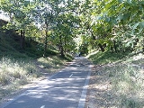
It is heavily used by local residents and recreational cyclists, due to its proximity to other paths, many suburbs, and connecting transport. The path was upgraded in Dec 2006 and is now fully sealed and divided. Signs are still lacking. The path, in some stages, follows the direct line of the old railway, in others it weaves through parks, and follows the side of the Alamein Line, continuing beyond Alamein Station underneath the still standing pylons for the overhead wiring to the Gardiners Creek Trail
Gardiners Creek Trail
The Gardiners Creek Trail is a shared use path for cyclists and pedestrians, which follows Gardiners Creek through the eastern suburbs of Melbourne, Victoria, Australia....
in Malvern East.
Following the Path
Leaving the Yarra River Trail head south on the Chandler HighwayChandler Highway
Chandler Highway is a short road in the inner eastern suburbs of Melbourne. It runs from Heidelberg Road in Alphington, across the Yarra River, using a narrow two-lane bridge over the Yarra River, then continues across the Eastern Freeway, then terminates at an intersection with Princess Street and...
and the Anniversary Outer Circle Trail can be found 0.6km later, just across the bridge that crosses the Eastern Freeway. A safer alternative is to continue along the Yarra River Trail from the Chandler Highway
Chandler Highway
Chandler Highway is a short road in the inner eastern suburbs of Melbourne. It runs from Heidelberg Road in Alphington, across the Yarra River, using a narrow two-lane bridge over the Yarra River, then continues across the Eastern Freeway, then terminates at an intersection with Princess Street and...
to Willsmere Park - 1.5km. You can cross under the Eastern Freeway at Willsmere Park and traverse to the Anniversary Outer Circle Trail via Hyde Park.
Despite numerous upgrades to the path, it can still be hard to follow in some sections:
Coming from the north the trail arrives at the junction of Harp Road, High Street and Valerie Street. Located in the junction is a tram stop and some vegetated median strips. Just circumvent all this as best as possible, while maintaining a direct line and the path will be refound on either side of High Street.
340 m past the Canterbury Road underpass, there is scouthall on the right (south east). Continue straight down the hill, rather than taking the path to the right at this point, which leads to East Camberwell Station.
The path swings to the right (south) at Myrtle Road and continues under the railbridge. The path parallels the southwest side of Myrtle Road. A short detour at this point (900 m), to the east along Warbuton Road, leads to the Maling Road coffee strip.
At Prospect Hill Road, 500 m south of the train line underpass, the path appears to terminate again. Cross Prospect Hill Road and turn right, continuing along 30 m and take a left into Spencer Road. Ride along Spencer Road until Riversdale Park is seen on the left (east). Ride across the park to the pedestrian crossing on the far side of the park at Riversdale Road.
Cross Riversdale Road and proceed left (east) towards Fordham Avenue, then turn right down Fordham Avenue (south). Follow the designated path, and turn right just before the scout hall. From here, the path is clear cut until its finish at the Solway Street footbridge.
Between Burwood
Burwood railway station, Melbourne
Burwood is a railway station on the Alamein line in Melbourne, Victoria, Australia. It is located between Trent Street and Bardolph Street, in the suburb of Glen Iris. It is located from Flinders Street Station in the centre of Melbourne and is in Metcard Zone 1.-Facilities:The station has two...
and Ashburton
Ashburton railway station, Melbourne
Ashburton is a railway station on the Alamein railway line in Melbourne, Victoria, Australia. It is located between Welfare Parade and Kelvin Grove, in the suburb of Ashburton. It also lies adjacent to High Street, where it connects with a bus to Glen Waverley and Glen Iris...
stations you pass by a small park with a playground (Summerhill Park). The Ferndale Park Trail
Ferndale Park Trail
The Ferndale Park Trail is a shared use path for cyclists and pedestrians in the suburb of Glen Iris, an inner eastern suburb of Melbourne, Victoria.It's useful as it provides a shortcut between Gardiners Creek Trail and Anniversary Trail...
starts here and acts as an alternative route to the Gardiners Creek Trail
Gardiners Creek Trail
The Gardiners Creek Trail is a shared use path for cyclists and pedestrians, which follows Gardiners Creek through the eastern suburbs of Melbourne, Victoria, Australia....
.
At the very southern end of the trail you can access the Gardiners Creek Trail. Access is provided via the small footbridge at the south end of Solway St. Due to flood damage the bridge was closed from April 2006 to June 2007. After being open for 3.5 years the bridge was washed away by flood waters very early in the morning of the 5th February, 2011, after heavy rain resulting from the remnants of Tropical Cyclone Yasi, rendering the bridge impassable. It is due to be replaced in the 2011-2012 financial year.
Once on the Gardiners Creek Trail, the Scotchmans Creek Trail
Scotchmans Creek Trail
The Scotchmans Creek Trail is a shared use path for cyclists and pedestrians, which follows Scotchmans Creek through the eastern suburbs of Melbourne, Victoria, Australia....
can be reached by riding along the path that goes through the Malvern Valley Public Golf Course. Then up and over the footbridge that crosses the Monash Freeway
Monash Freeway
Monash Freeway is an urban freeway in Victoria, Australia linking Melbourne's CBD to its southeastern suburbs and the Gippsland region. The entire stretch of the Monash Freeway bears the designation...
and on past East Malvern Station. Chadstone Shopping Centre
Chadstone Shopping Centre
Chadstone Shopping Centre is a super regional shopping centre located in the inner south-eastern suburb of Malvern East in the city of Melbourne, Australia...
and Homesglen Institute of TAFE are nearby.
Facilities
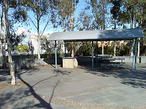
The path is fully sealed, either bitumen or concrete, and busy road crossings are serviced by pedestrian traffic lights. At various locations along the path, there are barbecues (at the park adjacent to Whitehorse Road crossing and Frog Hollow Reserve). Many parks are dotted along the path, such as ovals, playgrounds, tennis courts and cricket pitches.Connections
- Yarra River Trail in the North.
- The Ferndale Park TrailFerndale Park TrailThe Ferndale Park Trail is a shared use path for cyclists and pedestrians in the suburb of Glen Iris, an inner eastern suburb of Melbourne, Victoria.It's useful as it provides a shortcut between Gardiners Creek Trail and Anniversary Trail...
connects to the trail between Burwood and Ashburton Stations and acts as a short cut to the Gardiners Creek Trail. - A path from Alamein Station leads to Warrigal Rd via Markham Reserve.
- Gardiners Creek Trail and Scotchmans Creek Trail in the south. Bridge closed as of 5 February 2011 - use Winton Road and Glen Road.
North end at 37.788267°S 145.025162°E.
South end at 37.875385°S 145.073662°E.
External links
- Outer Circle Railway Trail - description of the trail
- Boroondara BUG - Detailed map of the Trail
- Boroondara BUG's proposal to close the gap between Markham Reserve and Holmesglen Station via a shared path alongside Warrigal Road. Creating a link to the Waverley Rail TrailWaverley Rail TrailThe Waverley Rail Trail is a combination of shared use path for cyclists and pedestrians and on-road bicycle route, which follows the Glen Waverley railway line from Holmesglen railway station to Glen Waverley railway station in the south eastern suburbs of Melbourne, Victoria, Australia.-...
.