
Gardiners Creek
Encyclopedia
Gardiners Creek, originally known as Kooyongkoot Creek, is a waterway in the eastern suburbs of Melbourne
, and part of the Yarra River
catchment.
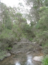
In a few sparse locations remnant riparian
bushland survives, however the majority of its length has been heavily urbanised
, and the creek has been degraded in much the same way as other Melbourne eastern suburban waterways such as the Mullum Mullum Creek and Koonung Creek
. The Gardiners Creek Trail
follows the creek for most of its length.
Wurundjeri
-Baluk group, which translates to 'haunt of the waterfowl'. The creek's current name was given in honour of early Melbourne land speculator and banker, John Gardiner
, who settled near the junction of Kooyongkoot Creek and the Yarra River in 1836.
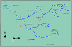
The creek originates in the suburb of Blackburn
, where many small creeks and gullies converge around Blackburn Lake
. It then flows southwest through Box Hill South
, Burwood
, and Ashwood
. Approximately at its junction with Scotchmans Creek in Malvern East
it turns northwest, then continues through Ashburton
, Glen Iris
, Malvern
, and Kooyong
, before finally flowing into the Yarra River in Hawthorn
.
, a shared use cycling and pedestrian track, follows the general course of Gardiners Creek from Blackburn to the Yarra River, where a bridge over the river links it to the Main Yarra Trail
.
The Monash Freeway/Citylink follow the Gardiners Creek valley from Malvern East to the Yarra River.
Melbourne
Melbourne is the capital and most populous city in the state of Victoria, and the second most populous city in Australia. The Melbourne City Centre is the hub of the greater metropolitan area and the Census statistical division—of which "Melbourne" is the common name. As of June 2009, the greater...
, and part of the Yarra River
Yarra River
The Yarra River, originally Birrarung, is a river in east-central Victoria, Australia. The lower stretches of the river is where the city of Melbourne was established in 1835 and today Greater Melbourne dominates and influences the landscape of its lower reaches...
catchment.
In a few sparse locations remnant riparian
Riparian zone
A riparian zone or riparian area is the interface between land and a river or stream. Riparian is also the proper nomenclature for one of the fifteen terrestrial biomes of the earth. Plant habitats and communities along the river margins and banks are called riparian vegetation, characterized by...
bushland survives, however the majority of its length has been heavily urbanised
Urbanization
Urbanization, urbanisation or urban drift is the physical growth of urban areas as a result of global change. The United Nations projected that half of the world's population would live in urban areas at the end of 2008....
, and the creek has been degraded in much the same way as other Melbourne eastern suburban waterways such as the Mullum Mullum Creek and Koonung Creek
Koonung Creek
Koonung Creek is a small tributary of the Yarra River in Melbourne's east. The creek originates in Nunawading near Springvale Road, and flows to join the Yarra at the border between Ivanhoe East, Bulleen and Balwyn North. The place the two waterways meet forms the borders between these suburbs...
. The Gardiners Creek Trail
Gardiners Creek Trail
The Gardiners Creek Trail is a shared use path for cyclists and pedestrians, which follows Gardiners Creek through the eastern suburbs of Melbourne, Victoria, Australia....
follows the creek for most of its length.
Naming
The creek's original name was Kooyongkoot, from the Woiwurrung language of the indigenous AustralianIndigenous Australians
Indigenous Australians are the original inhabitants of the Australian continent and nearby islands. The Aboriginal Indigenous Australians migrated from the Indian continent around 75,000 to 100,000 years ago....
Wurundjeri
Wurundjeri
The Wurundjeri are a people of the Indigenous Australian nation of the Woiwurrung language group, in the Kulin alliance, who occupy the Birrarung Valley, its tributaries and the present location of Melbourne, Australia...
-Baluk group, which translates to 'haunt of the waterfowl'. The creek's current name was given in honour of early Melbourne land speculator and banker, John Gardiner
John Gardiner (colonist)
John Gardiner was a nineteenth century Australian banker and pastoralist.-References:*A. S. Kenyon, 'The Overlanders', Victorian Historical Magazine, 10...
, who settled near the junction of Kooyongkoot Creek and the Yarra River in 1836.
Course
Gardiners Creek is over 30 km (18.6 mi) in length.The creek originates in the suburb of Blackburn
Blackburn, Victoria
Blackburn is a suburb in Melbourne, Victoria, Australia, 17 km east from Melbourne's central business district. Its Local Government Area is the City of Whitehorse. At the 2006 Census, Blackburn had a population of 11,958....
, where many small creeks and gullies converge around Blackburn Lake
Blackburn Lake Sanctuary
Blackburn Lake Sanctuary is an excellent example of regenerated and remnant bushland in suburban Melbourne, Victoria, Australia. It is located in the suburb of Blackburn...
. It then flows southwest through Box Hill South
Box Hill South, Victoria
Box Hill South is a suburb in Melbourne, Victoria, Australia, 14 km east from Melbourne's central business district. Its Local Government Area is the City of Whitehorse...
, Burwood
Burwood, Victoria
Burwood is a suburb in Melbourne, Victoria, Australia, 17 km east from Melbourne's central business district. Its Local Government Area is largely the City of Whitehorse but includes the City of Monash in its south west corner. At the 2006 Census, Burwood had a population of 11,886.-History:The...
, and Ashwood
Ashwood, Victoria
Ashwood is a suburb in Melbourne, Victoria, Australia, 14 km south-east from Melbourne's central business district. Its Local Government Area is the City of Monash...
. Approximately at its junction with Scotchmans Creek in Malvern East
Malvern East, Victoria
Malvern East is a suburb in Melbourne, Victoria, Australia, 11 km south-east from Melbourne's central business district. Its Local Government Area is the City of Stonnington...
it turns northwest, then continues through Ashburton
Ashburton, Victoria
Ashburton is a suburb in Melbourne, Victoria, Australia, 12 km south-east from Melbourne's central business district. Its Local Government Area is the City of Boroondara...
, Glen Iris
Glen Iris, Victoria
Glen Iris is a suburb in Melbourne, Victoria, Australia, 10 km south-east from Melbourne's central business district. Its Local Government Area are the Cities of Boroondara and Stonnington...
, Malvern
Malvern, Victoria
Malvern is a suburb in Melbourne, Victoria, Australia, 8 km south-east from Melbourne's central business district. Its Local Government Area is the City of Stonnington. At the 2006 Census, Malvern had a population of 9,422.-History:...
, and Kooyong
Kooyong, Victoria
Kooyong is a suburb in Melbourne, Victoria, Australia, south-east from Melbourne's central business district. Its Local Government Area is the City of Stonnington. At the 2006 Census, Kooyong had a population of 781....
, before finally flowing into the Yarra River in Hawthorn
Hawthorn, Victoria
Hawthorn is a suburb in Melbourne, Victoria, Australia, east from Melbourne's central business district. Its Local Government Area is the City of Boroondara...
.
Tributaries
- Unnamed watercourse through Blackburn/Forest Hill
- Unnamed watercourse through Wurundjeri WetlandsWurundjeri Walk TrailThe Wurundjeri Walk Trail is a shared use path for cyclists and pedestrians in the inner eastern suburbs of Blackburn South and Forest Hill in Melbourne, Victoria, Australia.The path is broken by many small road sections...
- Damper Creek
- Unnamed watercourse through Ashwood/Mount Waverley
- Murrumbeena Creek
- Scotchmans Creek
- Hercules Creek
- Back Creek
Parklands
Upstream to downstream:- Blackburn Lake SanctuaryBlackburn Lake SanctuaryBlackburn Lake Sanctuary is an excellent example of regenerated and remnant bushland in suburban Melbourne, Victoria, Australia. It is located in the suburb of Blackburn...
(Blackburn) - Furness Park (Blackburn)
- Blackburn Creeklands Reserve (Blackburn)
- Blacks Walk (Blackburn)
- R.H.L. Sparks Reserve (creek piped underground) (Box Hill)
- Wembley Park (Box Hill South)
- Box Hill Golf Club (Box Hill South)
- Gardiners Creek Reserve (Burwood)
- Local History Park (Burwood)
- Gardiners Reserve (Burwood)
- Ashwood Reserve (Ashwood)
- Markham Reserve (Ashburton)
- Malvern Valley Public Golf Course (Malvern East)
- Darling Park (Malvern East)
- Dorothy Laver Reserve (Glen Iris)
- Dorothy Laver Reserve West (Glen Iris)
- Glen Iris Wetlands (Glen Iris)
- Glen Iris Park (Glen Iris)
- Muswell Bend Park (Glen Iris)
- Glenburn Bend Park (Glen Iris)
- Nettleton Park Reserve (Glen Iris)
- Kyarra Park (separated since freeway construction) (Glen Iris)
- Howard Dawson Reserve (Glen Iris)
- Burke Road South Reserve (Glen Iris)
- Gardiner Park (separated since freeway construction) (Gardiner)
- Tooronga Park (separated since freeway construction) (Malvern)
- Patterson Reserve (Hawthorn)
- H.A. Smith Reserve (separated since freeway construction) (Hawthorn)
- Kooyong Park (Kooyong)
- Kooyong StadiumKooyong StadiumKooyong Stadium, at the Kooyong Lawn Tennis Club, is a tennis venue, located in Melbourne, Australia. The stadium was built in 1927 and has a capacity of 8,500....
(Kooyong)
Transport
The Gardiners Creek TrailGardiners Creek Trail
The Gardiners Creek Trail is a shared use path for cyclists and pedestrians, which follows Gardiners Creek through the eastern suburbs of Melbourne, Victoria, Australia....
, a shared use cycling and pedestrian track, follows the general course of Gardiners Creek from Blackburn to the Yarra River, where a bridge over the river links it to the Main Yarra Trail
Main Yarra Trail
The Yarra Trail is a shared use path for cyclists and pedestrians, which follows the Yarra River through the north eastern suburbs of Melbourne, Victoria, Australia....
.
The Monash Freeway/Citylink follow the Gardiners Creek valley from Malvern East to the Yarra River.
Crossings
Upstream to downstream:- Central Road
- Lake Road and Weir (Blackburn Lake)
- Jeffery Street
- Blackburn Road
- Main Street
- Blackburn Creeklands Footbridges
- Pakenham Street
- Middleborough Road
- Canterbury Road
- Station Street
- Burwood HighwayBurwood HighwayBurwood Highway is a major transportation link with Melbourne's eastern suburbs. It begins in the suburb of Kooyong, Melbourne at the junction of the Monash Freeway as Toorak Road between Monash Freeway and Warrigal Road, and finishes in Belgrave, Victoria in the Dandenong Ranges...
- Highbury Road
- High Street Road
- Warrigal RoadWarrigal RoadWarrigal Road is a major inner urban road in southeastern Melbourne, Australia. On weekdays, it is usually congested as it runs through many major suburbs along its route, traversing Melbourne's inner eastern and south-eastern suburbs. This includes suburbs such as Chadstone, Oakleigh, and...
- Winton Road
- Darling Park Footbridge
- Dunlop Street
- Glen Iris Park Footbridge
- High Street
- Nettleton Park Footbridge
- Great Valley Road
- Burke RoadBurke Road, MelbourneBurke Road is a major north-south thoroughfare in Melbourne, Australia. It runs from Ivanhoe to Caulfield, and includes the major shopping district at Camberwell...
- Tooronga Road
- Toorak Road
- Monash FreewayMonash FreewayMonash Freeway is an urban freeway in Victoria, Australia linking Melbourne's CBD to its southeastern suburbs and the Gippsland region. The entire stretch of the Monash Freeway bears the designation...
/CityLinkCityLinkCityLink is a system of tolled urban Highways in Melbourne, Victoria, Australia. The company Transurban was awarded the contract to augment two existing freeways and construct two new Toll roads—labelled the Western and Southern Links—directly linking a number of existing freeways to... - Glenferrie RoadGlenferrie Road, MelbourneGlenferrie Road is a major north–south thoroughfare in Melbourne, Australia.It runs from Kew to Malvern, and includes major shopping districts at both Hawthorn and Malvern.Tram route 16 runs along the entire length of Glenferrie Road...