
Freeway Complex Fire
Encyclopedia
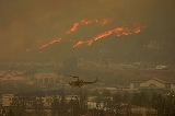
The Freeway Complex Fire was a wildfire
in the Santa Ana Canyon
area of Orange County
in the US state of California
. The fire is notable for the extensive property damage in Anaheim Hills and Yorba Linda. 314 residences were destroyed or damaged in these two communities.
. The fire spread west and north into the hillsides of Yorba Linda
and south into Anaheim Hills
, where multiple businesses and residences were destroyed. It also burned homes in Olinda Ranch along Carbon Canyon Road in Brea
, burned through much of Chino Hills
, then spread north into Diamond Bar
.
The Landfill Fire, also known as the "Brea Fire," was reported at 10:43 a.m. PDT on Saturday, November 15, 2008, and started near the 1900 block of Valencia Avenue in Brea
, just south of the Olinda Landfill. It quickly spread West and eventually jumped the Orange (57) Freeway.
The Landfill Fire merged with the Freeway Fire at 3:30 a.m. PDT on November 16, 2008. At approximately 7:00 a.m. PDT the two fires were officially renamed the Triangle Complex Fire. Around 12:45 p.m. the "Triangle Complex Fire" had been renamed again to the "Freeway Complex Fire" still using the OCFA incident number CA-ORC-08075221.
 About 40,000 were evacuated. Areas under mandatory evacuation during the fires included:
Also in Corona there was an evacuation
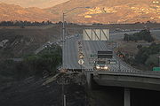 The Freeway Complex Fire forced the closure of the Riverside (91) Freeway
, the Chino Valley (71) Freeway
and the 241 Transportation Corridor
. The Landfill fire (a.k.a Brea Fire) temporarily closed the Orange (57) Freeway in northern Orange County.
in Sylmar (November 14). Both were preceded by an unrelated fire along the Pacific Coast, the Tea Fire
in Santa Barbara
and Montecito
(November 13).
Wildfire
A wildfire is any uncontrolled fire in combustible vegetation that occurs in the countryside or a wilderness area. Other names such as brush fire, bushfire, forest fire, desert fire, grass fire, hill fire, squirrel fire, vegetation fire, veldfire, and wilkjjofire may be used to describe the same...
in the Santa Ana Canyon
Santa Ana Canyon
Santa Ana Canyon is where the Santa Ana River passes between the Santa Ana Mountains and the Chino Hills, near the intersection of Orange, Riverside, and San Bernardino Counties. It receives particularly strong Santa Ana winds in comparison to surrounding areas, hence the name.-History:Originally,...
area of Orange County
Orange County, California
Orange County is a county in the U.S. state of California. Its county seat is Santa Ana. As of the 2010 census, its population was 3,010,232, up from 2,846,293 at the 2000 census, making it the third most populous county in California, behind Los Angeles County and San Diego County...
in the US state of California
California
California is a state located on the West Coast of the United States. It is by far the most populous U.S. state, and the third-largest by land area...
. The fire is notable for the extensive property damage in Anaheim Hills and Yorba Linda. 314 residences were destroyed or damaged in these two communities.
Summary
Freeway Complex Fire, also known as the Triangle Complex Fire or Corona Fire, began 9:01 a.m. PDT November 15, 2008, along the Riverside Freeway (California State Route 91) in the riverbed of the Santa Ana River located in Corona, CaliforniaCorona, California
Corona is a city in Riverside County, California, United States. As of the 2010 census, the city had a population of 152,374, up from 124,966 at the 2000 census...
. The fire spread west and north into the hillsides of Yorba Linda
Yorba Linda, California
Yorba Linda is a suburban city in northeastern Orange County, California, approximately northeast of Downtown Santa Ana, and southeast of Downtown Los Angeles....
and south into Anaheim Hills
Anaheim Hills, Anaheim, California
Anaheim Hills is a planned community encompassing the eastern portions of the city of Anaheim, in Orange County, California.- Location :Anaheim Hills is located just south of Yorba Linda, California, opposite the 91 freeway at Imperial Highway. The western border is the 55 freeway opposite the...
, where multiple businesses and residences were destroyed. It also burned homes in Olinda Ranch along Carbon Canyon Road in Brea
Brea, California
Brea is a city in Orange County, California. The population, as of the 2010 Census was 39,282.The city began as a center of crude oil production, was later propelled by citrus production, and is now an important retail center because of the large Brea Mall and the recently redeveloped Brea Downtown...
, burned through much of Chino Hills
Chino Hills, California
Chino Hills is a Los Angeles suburb located in the southwestern corner of San Bernardino County, California, United States. The city borders Los Angeles County on its northwest side, Orange County to its south, and Riverside County to its southeast...
, then spread north into Diamond Bar
Diamond Bar, California
Diamond Bar is a city in eastern Los Angeles County, California, United States. The population was 55,544 at the 2010 census, down from 56,287 at the 2000 census. It is named after the "diamond over a bar" branding iron registered in 1918 by ranch owner Frederick E...
.
The Landfill Fire, also known as the "Brea Fire," was reported at 10:43 a.m. PDT on Saturday, November 15, 2008, and started near the 1900 block of Valencia Avenue in Brea
Brea, California
Brea is a city in Orange County, California. The population, as of the 2010 Census was 39,282.The city began as a center of crude oil production, was later propelled by citrus production, and is now an important retail center because of the large Brea Mall and the recently redeveloped Brea Downtown...
, just south of the Olinda Landfill. It quickly spread West and eventually jumped the Orange (57) Freeway.
The Landfill Fire merged with the Freeway Fire at 3:30 a.m. PDT on November 16, 2008. At approximately 7:00 a.m. PDT the two fires were officially renamed the Triangle Complex Fire. Around 12:45 p.m. the "Triangle Complex Fire" had been renamed again to the "Freeway Complex Fire" still using the OCFA incident number CA-ORC-08075221.
Structures Damaged or Destroyed
- 187 residential structures destroyed (includes multi-family residences)
- 127 residential structures damaged
- 2 commercial properties destroyed
- 2 commercial properties damaged
- 11 outbuildings/other destroyed
- 32 outbuildings/other damaged
Burn Areas
It was calculated that 30305 acres (12,264 ha) were burned including 90% of Chino Hills State Park. The calculated acreage burned would make the fire the fourth largest fire on record in Orange County History behind the 1969 Paseo Grande Fire, Steward Fire of 1958 and the Green River Fire of 1948.Evacuations
- Yorba Linda - East and South of Village Center to the County Line (Released by 1730 November 16, 2008)
- Brea - east of State College & Brea Blvd/Brea Canyon Rd., north of Imperial Highway, west of Prospect
- Anaheim - West of the 241 freeway, south of the 91 Freeway, north of Canyon Rim Rd., and west of Deer Canyon Park and Fairmont Park including SAVI Ranch. (Released by 1730 November 16, 2008)
- Carbon Canyon - East of Valencia to the County Line including Olinda Village, Hollydale.
- Chino Hills - Sleepy Hollow, Carriage Hills, Oak Tree Downs, Vellano Estates and Golf Course, Los Serranos Ranch, Butterfield Ranch (up to Soquel Canyon Road), Ridgegate Estates & Western Hills Estates
- Diamond Bar - The Country, Falcon Ridge, Chirping Sparrow, Hawk Wood, Running Branch, Fair Wind & High Bluff
Also in Corona there was an evacuation
Freeway closures
California State Route 91
State Route 91 is a major east–west freeway located entirely within Southern California and serving several regions of the Greater Los Angeles metropolitan area...
, the Chino Valley (71) Freeway
California State Route 71
State Route 71 is the Chino Valley Freeway, formerly the Corona Expressway and before then the Temescal Freeway, a freeway/highway of about 15 miles in length located entirely within Southern California, United States...
and the 241 Transportation Corridor
California State Route 241
State Route 241 is a state highway in the U.S. state of California. For its entire run, Route 241 is a toll road. Its northern half is part of the Eastern Toll Road while its southern half is part of the Foothill Toll Road....
. The Landfill fire (a.k.a Brea Fire) temporarily closed the Orange (57) Freeway in northern Orange County.
School closures
- Anaheim Hills Montessori
- Brea Olinda Unified School DistrictBrea Olinda Unified School DistrictBrea Olinda Unified School District is the school district serving the City of Brea in Orange County, California, United States. It also serves portions of the nearby cities of Fullerton, Yorba Linda and La Habra.The school district consists of:...
- Calvary Christian School
- Chino Valley Unified School District
- Diamond Bar schools in the Walnut Valley Unified School DistrictWalnut Valley Unified School DistrictThe Walnut Valley Unified School District is located in the eastern portion of Los Angeles County and is a part of the Greater Los Angeles Area of the U.S. state of California. It serves the city of Walnut and much of the city of Diamond Bar....
- Esperanza High School
- Placentia-Yorba Linda Unified School DistrictPlacentia-Yorba Linda Unified School DistrictThe Placentia-Yorba Linda Unified School District is a public school district that serves Placentia, Yorba Linda and parts of Anaheim, Brea, and Fullerton located in Orange County, California. The school district covers and employs 2,500 people...
- St. Angela Merici Catholic School
- St. Francis of Assisi Catholic School
- St. Joseph Catholic School and Preschool
- Vineyard Christian Preschool and Elementary School
- Walnut Valley Unified School DistrictWalnut Valley Unified School DistrictThe Walnut Valley Unified School District is located in the eastern portion of Los Angeles County and is a part of the Greater Los Angeles Area of the U.S. state of California. It serves the city of Walnut and much of the city of Diamond Bar....
Other Fires in the Southland
Preceding this fire was an outbreak to the northwest, the Sayre FireSayre Fire
The Sayre Fire, also known as the Sylmar Fire, is a November 2008 wildfire that resulted in the loss of 489 residences in Los Angeles, California, United States, the "worst loss of homes due to fire" in the city's history. The fire was first reported at 10:29 p.m. PDT on November 14, 2008, in the...
in Sylmar (November 14). Both were preceded by an unrelated fire along the Pacific Coast, the Tea Fire
Montecito Tea Fire
The Montecito Tea Fire is a wildfire that began on November 13, 2008, destroying 210 homes in the cities of Montecito and Santa Barbara, California in the United States of America. It was the first of several November 2008 wildfires that burned hundreds of homes November 13–15, 2008...
in Santa Barbara
Santa Barbara, California
Santa Barbara is the county seat of Santa Barbara County, California, United States. Situated on an east-west trending section of coastline, the longest such section on the West Coast of the United States, the city lies between the steeply-rising Santa Ynez Mountains and the Pacific Ocean...
and Montecito
Montecito
Montecito may refer to:*Montecito, California, a census-designated place in Santa Barbara County, California* Montecito , the codename used to designate a revision of the Intel Itanium 2 processor...
(November 13).