

Frederick Reefs
Encyclopedia
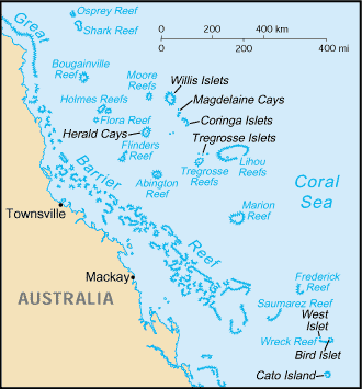
Coral Sea Islands
The Coral Sea Islands Territory includes a group of small and mostly uninhabited tropical islands and reefs in the Coral Sea, northeast of Queensland, Australia. The only inhabited island is Willis Island...
, over 220 nautical miles (407.4 km) northeast of Gladstone, Queensland
Gladstone, Queensland
- Education :Gladstone has several primary schools, three high schools, and one university campus, Central Queensland University. It is also home to CQIT Gladstone Campus.- Recreation :...
. The reef gets its name from the Frederick
Frederick (ship)
The Frederick was a ship that was wrecked at Cape Flinders on Stanley Island, Queensland, Australia in 1818.Frederick Reefs in the Coral Sea Islands, over northeast of Gladstone, Queensland gets its name from the Frederick, which first reported sighting of the reef.The reefs were discovered in...
, which first reported sighting of the reef.
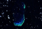
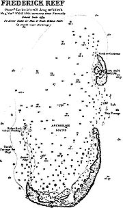
Frederick Reef is a small atoll with a large rock called Ridge Rock at the southern end, a sand cay called Observatory Cay and a lighthouse at the northern end the only permanently dry land, although there are a few of others cays that can be awash at high tide. The reef is around 30km2.
The reefs forms a J shape to form a semi-enclosed lagoon, known as Anchorage Sound, with an opening on the North side. The complex measures about 10 by, with an area of 30 square kilometre.
The reef is located is some deep water and drops sharply to over 2500 metres (8,202.1 ft) on the western side.
General description
Great Barrier Reef
The Great Barrier Reef is the world'slargest reef system composed of over 2,900 individual reefs and 900 islands stretching for over 2,600 kilometres over an area of approximately...
,
The reef complex lies 540 kilometres (335.5 mi) due east from the city of Mackay, Queensland
Mackay, Queensland
Mackay is a city on the eastern coast of Queensland, Australia, about north of Brisbane, on the Pioneer River. Mackay is nicknamed the sugar capital of Australia because its region produces more than a third of Australia's cane sugar....
or 450 kilometres (279.6 mi) northeast of the city of Gladstone. The reefs are part of the southern reefs of the Coral Sea and as such are located in deep oceanic waters off the Coral Sea Shelf.
Aside from it’s costal neighbours it also lies 175 kilometres (108.7 mi) east from the Swains Reefs; the lower part of the Great Barrier Reef. Frederick Reefs is approximately 95 kilometres (59 mi) northeast of the Saumarez Reefs
Saumarez Reefs
Saumarez Reefs is one of the southernmost reefs to be located in the Coral Sea Islands and part of the Coral Sea Shelf; it contains three main reefs and numerous smaller reefs all of which form a large crescent-shaped formation open to the northwest, about 27 by 14 km, area less than 300 km².There...
and 120 kilometres (74.6 mi) west of the northwest extremity of Kenn Reefs
Kenn Reefs
Kenn Reef is a submerged coral atoll off the Pacific coast of Queensland, Australia. It is about 15 by 8 km and appears as either a backward facing “L“ or a boot...
.
The reefs form a semi-enclosed lagoon or body of water known as Anchorage Sound; protected on most sides but open on the north side. On the southern side of the reef lies Observatory Cay, (21°02'S., 154°23'E.), the only permanently dry land, although there are a few of others cays that can be awash at high tide. Observatory Cay is approximately 1.8 metres (5.9 ft) above sea level; with a possible landing site on its northern side through a boat channel which leads in from North East through the reef. As the cay lies near the southern edge of the reef, the surf sometimes breaks over it in heavy gales.
Similar to other smaller sand cays and spits, the position of the sand spit can move. In 1983, it was reported that Observatory Cay lay about 750 metres (2,460.6 ft) west of the charted position. It has also been reported that the reef complex has at least 4 or 5 other sand cays on the southern reef which does not cover with water at high tide other than Observatory Cay.
A solitary leaning rock, 1.2 metres (3.9 ft) high, lies on the western extremity of the Observatory Cay southern reef, 2.4 kilometres (1.5 mi) west-northwest of Observatory Cay.
From Observatory Cay, the southern part of the reef extends to the north and northeast for 6.2 kilometres (3.9 mi).
Danger Ridge (21°00'S., 154°21'E.) is a narrow ridge connecting the western end of Observation Cay and Ridge Rock.
The North Reef Extreme is located to the north of Observatory Cay with its southern extremity about 3 kilometres (1.9 mi) north southern extremity of the Observatory Cay reef. It is about 2.7 kilometres (1.7 mi) long and about 900 metres (2,952.8 ft) wide. A small cay ls located 900 metres (2,952.8 ft) south of Frederick Reef Light. The Light has a nominal range of 20 kilometres (12.4 mi), and stands at an elevation of 33 metres (108.3 ft)
Discovery
The reefs were discovered in 1812 by the Frederick. The reefs were described in the ship's log:Shipwreck of Royal Charlotte
On 29 April 1825, Royal Charlotte arrived in Sydney from England with a load of convicts. The ship then took on detachments of the 20th, 46th46th (South Devonshire) Regiment of Foot
The 46th Regiment of Foot was an infantry regiment of the British Army, created in 1741 and amalgamated into the Duke of Cornwall's Light Infantry in 1881.-History:...
, and 49th Regiments for transport to India by Batavia. On 11 June, the ship ran aground on Frederick Reefs; the masts were cut away to steady her while the crew and soldiers moved to shore with water and provisions before she sank. Only two lives were lost. A party took the surviving longboat and travelled to Moreton Bay
Moreton Bay
Moreton Bay is a bay on the eastern coast of Australia 45 km from Brisbane, Queensland. It is one of Queensland's most important coastal resources...
, arriving in July and causing the brig Amity to be desptached to collect survivors.
Grounding of USS Tiru
On 2 November 1966, the United States submarine USS TiruUSS Tiru (SS-416)
USS Tiru , a Balao-class submarine, was a ship of the United States Navy named for the tiru.Tiru—laid down on 17 April 1944 at Vallejo, Calif., by the Mare Island Navy Yard—remained uncompleted for three years as a result of the curtailment of the submarine building program at the end of World War II...
departed from Subic Bay
Subic Bay
Subic Bay is a bay forming part of Luzon Sea on the west coast of the island of Luzon in Zambales, Philippines, about 100 kilometers northwest of Manila Bay. Its shores were formerly the site of a major United States Navy facility named U.S...
. On 4 November, the submarine ran aground on Frederick Reefs. For two days, the submarine attempted to back off the reef under her own power, but was unsuccessful. On 6 November, Australian destroyer HMAS Vendetta
HMAS Vendetta (D08)
HMAS Vendetta was one of three Daring class destroyers built for and operated by the Royal Australian Navy . The destroyer was built by Williamstown Naval Dockyard and entered service in 1958. During her early career, Vendetta was deployed to the Far East Strategic Reserve on multiple occasions...
and civilian tugboat Carlock arrived to assist the salvage of Tiru. The submarine was towed to Brisbane, where she was drydocked for emergency repairs and damage assessment.
Following temporary repairs to her sonar dome, outer hull, and keel, the submarine gingerly made her way from Australia to the United States Naval Ship Repair Facility, Yokosuka, Japan. En route, Tiru called at Guam
Guam
Guam is an organized, unincorporated territory of the United States located in the western Pacific Ocean. It is one of five U.S. territories with an established civilian government. Guam is listed as one of 16 Non-Self-Governing Territories by the Special Committee on Decolonization of the United...
to provision alongside and pick up new crew members. Arriving at Yokosuka on 29 November, the submarine entered drydock for restricted availability.
Grounding of Jhansi Ki Rani
On 23 April 1986, Jhansi Ki Rani, an India-flagged bulk carrier departed from Newcastle, New South Wales for Japan with 74,000 tonnes of coal onboard. The route for the voyage had been planned and plotted by the Second Officer, approved by the Master, and was to take the vessel 10 nautical miles (18.5 km) east of Frederick Reef sometime on 26 April.During the Second Officer's watch, constant rain had reduced visibility from 10 kilometres (6.2 mi) to 3 kilometres (1.9 mi). At 1515, an object was detected on radar, 17.5 nautical miles (32.4 km) away to port. It was assumed that this was the Frederick Reefs Lighthouse, but was actually another ship, MV Fort Resolution. Two hours later, another radar echo was picked up, 9 nautical miles (16.7 km) away. While attempting to clarify the indistinct radar signal, it became obscured by rain clutter, then vanished. Assumed to be a ship, the lookout was instructed to keep watch off the starboard bow. The ship's Master arrived on the bridge at 1725, to confirm the progress of the voyage and to prepare for the passing of Frederick Reefs.
Shortly after this, the Chief Officer and lookout both reported a white line close ahead; waves breaking over the edge of the reef. The ship was ordered to swing hard to port, but did not swing far enough to clear the southern edge of the reef, running aground 5.7 nautical miles (10.6 km) from the tower. The engines were stopped, and at 1736 were put full astern in an attempt to pull the ship off the reef. After almost two hours, the failed attempts ceased.
The vessel was recovered and refloated on 4 May, and after being anchored for inspection, was towed to Singapore for repairs, then put up for auction with her cargo of coal.