

Fort Point, Boston
Encyclopedia
Neighborhoods in Boston, Massachusetts
Boston is sometimes called a "city of neighborhoods." There are 21 designated neighborhood areas in Boston used by the city. Bostonians also have a variety of overlapping districts which they consider neighborhoods, squares, areas, etc. Many other boundaries established by the city's residential...
or district of Boston, Massachusetts, which is named after the location of a fort which guarded the city in colonial times.
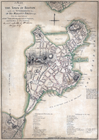
Fort Hill was located near what is today the intersection of Oliver and High Streets. At least until 1675, (see map) the hill jutted out into the Atlantic Ocean
Atlantic Ocean
The Atlantic Ocean is the second-largest of the world's oceanic divisions. With a total area of about , it covers approximately 20% of the Earth's surface and about 26% of its water surface area...
, hence the designation of being a "point". Its height and proximity to the sea made the hill an advantageous point to put defensive cannon
Cannon
A cannon is any piece of artillery that uses gunpowder or other usually explosive-based propellents to launch a projectile. Cannon vary in caliber, range, mobility, rate of fire, angle of fire, and firepower; different forms of cannon combine and balance these attributes in varying degrees,...
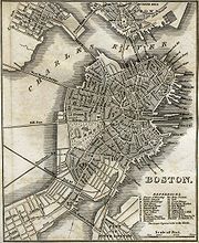
s. Between 1866 and 1872, the City of Boston undertook a redevlopment project on Fort Hill in attempt to add more land for business facilities. The project called for the Hill to be leveled, for the streets to be widened, and for all buildings to be raized. Today the land is flat and largely occupied by the towers of International Place
One International Place
One International Place is a modern skyscraper in the Financial District neighborhood of Boston, Massachusetts. Built in 1987, it is Boston's fifth-tallest building, standing 600 feet tall and housing 46 floors. The building is very prominent in the city's skyline, particularly when viewed from...
. Landfill has also extended the shoreline outward, so the location of the old fort is no longer directly on the waterfront
Boston Harbor
Boston Harbor is a natural harbor and estuary of Massachusetts Bay, and is located adjacent to the city of Boston, Massachusetts. It is home to the Port of Boston, a major shipping facility in the northeast.-History:...
.
The boundaries of the modern neighborhood of Fort Point are somewhat ill-defined. At its broadest extent, it includes the land a few blocks on either side of the Fort Point Channel
Fort Point Channel
Fort Point Channel is a maritime channel separating South Boston from downtown Boston, Massachusetts, feeding into Boston Harbor. The south part of it has been gradually filled in for use by the South Bay rail yard and several highways...
(which due to landfill is considerably smaller than it was in colonial times). The Fort Point artists' community is located on the opposite side of the channel. This is also called the South Boston Waterfront area or Seaport District. Real estate listings include "Fort Point" locations east of the channel and west of the Boston Convention and Exhibition Center
Boston Convention and Exhibition Center
The Boston Convention and Exhibition Center is the largest exhibition center in the Northeast United States, with some 516,000 square feet of contiguous exhibition space. It is located on Summer Street near the South Boston waterfront, Boston's World Trade Center, and across the harbor from Logan...
and the Boston World Trade Center. (Further south is South Boston proper.) The Boston Redevelopment Authority
Boston Redevelopment Authority
The Boston Redevelopment Authority is the municipal planning and development agency for Boston, working on both housing and commercial developments.The BRA was established by the Boston city council and the Massachusetts legislature in 1957...
defines the Fort Point District within the neighborhood of South Boston as "an area of approximately 100 acre (0.404686 km²) defined by the Fort Point Channel to the west, Summer Street to the north, the Bypass Road to the east, and West 2nd Street to the south."
The Summer Street Bridge, which crosses the channel, has a sign which welcomes eastbound travelers to South Boston, and westbound travelers to Fort Point. The United States Postal Service
United States Postal Service
The United States Postal Service is an independent agency of the United States government responsible for providing postal service in the United States...
Bulk Mail Center at Fort Point Station is located between the channel and South Station
South Station (Boston)
South Station, New England's second-largest transportation center , located at the intersection of Atlantic Avenue and Summer Street in Dewey Square, Boston, Massachusetts, is the largest train station and intercity bus terminal in Greater Boston, a prominent train station in the northeastern...
. To the northwest is Chinatown. The northeastern section of the Fort Point neighborhood, on the east side of the channel, could be said to overlap with the Financial District
Financial District, Boston, Massachusetts
The Financial District of Boston, Massachusetts, United States is located in the downtown area near Government Center and Chinatown.Like many areas within Boston, the Financial District has no official definition. It is roughly bounded by Atlantic Avenue, State Street, and Devonshire Street...
.
The Fort Point neighborhood was featured in Martin Scorsese's 2006 film The Departed
The Departed
The Departed is a 2006 American crime thriller film, fashioned as a remake of the 2002 Hong Kong film Infernal Affairs. The film was directed by Martin Scorsese and written by William Monahan...
. An alley between Thompson Pl. and Farnsworth St. provided the setting for the fictional address "344 Wash." Additionally, the dramatic views of downtown Boston from the rooftops of Fort Point were prominently featured in the film.
In 2001, the Fort Point District was petitioned as a Landmark District with the Boston Landmarks Commission. In 2007, a Mayoral-appointed Study Committee began drafting District guidelines. In December 2008, Mayor Menino
Thomas Menino
Thomas Michael "Tom" Menino is the mayor of Boston, Massachusetts, United States and the city's first Italian-American mayor...
and the Boston Landmarks Commission voted in favor of the guidelines which were officially approved on January 28, 2009 by the Boston City Council.
External links
- Fort Point Neighborhood Alliance official website
- Fort Point Artist Community
- Fort Point Theatre Channel
- Seaport Alliance for a Neighborhood Design (SAND)
- Fort Point Stage & Outdoor Movie Series
- Fort Point Blog
- Boston Public Library. Photos of Ft. Point from the Boston Wharf Company
- Fort Point Channel Boston Blog