

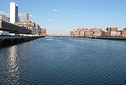
Fort Point Channel
Encyclopedia
Channel (geography)
In physical geography, a channel is the physical confine of a river, slough or ocean strait consisting of a bed and banks.A channel is also the natural or human-made deeper course through a reef, sand bar, bay, or any shallow body of water...
separating South Boston from downtown Boston, Massachusetts, feeding into Boston Harbor
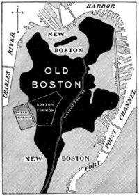
Boston Harbor
Boston Harbor is a natural harbor and estuary of Massachusetts Bay, and is located adjacent to the city of Boston, Massachusetts. It is home to the Port of Boston, a major shipping facility in the northeast.-History:...
. The south part of it has been gradually filled in for use by the South Bay
South Bay, Boston, Massachusetts
South Bay is a 10-acre site in Boston, Massachusetts sandwiched between Chinatown and the Leather District. It is roughly bounded by Kneeland Street, Hudson Street, the Massachusetts Turnpike mainline, and the Interstate 93 mainline. Currently owned by the Massachusetts Turnpike Authority , the...
rail yard
Rail yard
A rail yard, or railroad yard, is a complex series of railroad tracks for storing, sorting, or loading/unloading, railroad cars and/or locomotives. Railroad yards have many tracks in parallel for keeping rolling stock stored off the mainline, so that they do not obstruct the flow of traffic....
and several highway
Highway
A highway is any public road. In American English, the term is common and almost always designates major roads. In British English, the term designates any road open to the public. Any interconnected set of highways can be variously referred to as a "highway system", a "highway network", or a...
s (specifically the Central Artery
Central Artery
The John F. Fitzgerald Expressway, known locally as the Central Artery, is a section of freeway in downtown Boston, Massachusetts, designated as Interstate 93, U.S. Route 1 and Route 3. It was initially constructed in the 1950s as a partly elevated and partly tunneled divided highway...
and the Southeast Expressway). At its south end, the channel once widened into South Bay (Boston)
South Bay
South Bay may refer to:In the USA:* South Bay , subregion of the San Francisco Bay Area* South Bay, Los Angeles, region of Los Angeles County* South Bay, former name of Fields Landing, California...
, from which the Roxbury Canal continued southwest where the Massachusetts Avenue Connector is now. The channel is surrounded by the Fort Point
Fort Point, Boston
Fort Point is a neighborhood or district of Boston, Massachusetts, which is named after the location of a fort which guarded the city in colonial times....
neighborhood, which is also named after the same colonial-era fort.
The banks of the channel are still busy with activity. South of Summer Street on the west side of the channel is a large United States Postal Service
United States Postal Service
The United States Postal Service is an independent agency of the United States government responsible for providing postal service in the United States...
facility. A large parcel, home to Gillette, lies at the southeast corner of the channel. The back of the Federal Reserve Bank of Boston
Federal Reserve Bank of Boston
The Federal Reserve Bank of Boston, commonly known as the Boston Fed, is responsible for the First District of the Federal Reserve, which covers most of Connecticut , Massachusetts, Maine, New Hampshire, Rhode Island and Vermont. It is headquartered in the Federal Reserve Bank Building in Boston,...
looks over the channel, and another federal building, the John Joseph Moakley United States Courthouse
John Joseph Moakley United States Courthouse
The John Joseph Moakley United States Courthouse is a federal courthouse for the United States Court of Appeals for the First Circuit and the United States District Court for the District of Massachusetts, located on Fan Pier on the Boston, Massachusetts waterfront...
, lies on Fan Pier at the mouth of the channel. One of Boston's odder attractions, the Hood Milk Bottle, lies on the banks as well, next to Boston Children's Museum
Boston Children's Museum
Boston Children's Museum is a children's museum in Boston, Massachusetts, dedicated to the education of children. Located on Children's Wharf along the Fort Point Channel, Boston Children's Museum is the second oldest children's museum in the United States...
. During the 1980s, a nightclub and popular concert venue called The Channel
The Channel (nightclub)
The Channel was a Boston music venue that was part of the underground arts community of south Boston .-History:Joe Cicerone founded The Channel in 1980, choosing the name because the club sat at the edge of the Fort Point Channel, which separates South Boston from the Financial District...
was located on the South Boston bank.
Crossings
- Northern Avenue Bridge
- Evelyn Moakley Bridge (New Northern Avenue/Seaport Boulevard)
- Silver LineSilver Line (MBTA)The Silver Line is the only bus rapid transit line currently operated by the Massachusetts Bay Transportation Authority . It operates in two sections; the first runs from Dudley Square in Roxbury to downtown Boston, Massachusetts and South Station, mostly via Washington Street, with buses...
tunnel - Congress Street Bridge 1850
- Summer Street Bridge 1899
- New York and New England RailroadNew York and New England RailroadThe New York and New England Railroad was a major railroad connecting southern New York state with Hartford, Connecticut, Providence, Rhode Island and Boston, Massachusetts. It operated from 1873 to 1893. Prior to 1873 it was known as the Boston, Hartford and Erie Railroad, which had been formed by...
(gone) - Mount Washington Avenue Bridge (gone)
- Fort Point Channel Tunnel (I-90)
- Dorchester Avenue Bridge (formerly Federal Street Bridge)
- Atlantic Avenue Viaduct (gone)
- New York, New Haven and Hartford RailroadNew York, New Haven and Hartford RailroadThe New York, New Haven and Hartford Railroad , was a railroad that operated in the northeast United States from 1872 to 1968 which served the states of Connecticut, New York, Rhode Island, and Massachusetts...
and the wye connection to the west-facing lines (now used by the MBTA Commuter RailMBTA Commuter RailThe MBTA Commuter Rail serves as the regional rail arm of the Massachusetts Bay Transportation Authority, in the United States. It is operated under contract by the Massachusetts Bay Commuter Railroad Company a joint partnership of Veolia Transportation, Bombardier Transportation and Alternate...
) and the Red LineRed Line (MBTA)The Red Line is a rapid transit line operated by the MBTA running roughly north-south through Boston, Massachusetts into neighboring communities. The line begins west of Boston, in Cambridge, Massachusetts at Alewife station, near the intersection of Alewife Brook Parkway and Route 2...
tunnel roughly underneath - Broadway Bridge (relocated, new bridge opened January 19, 1999http://groups-beta.google.com/group/ne.transportation/browse_frm/thread/65630f6d9f0e7299/202c8d80cc75868d?q=%22old+broadway+bridge%22+boston&rnum=1&hl=en#202c8d80cc75868d)
The channel now ends here; the remaining bridges cross the South Bay Yard.
- West Fourth Street Bridge 1958 (formerly Dover Street, with an older bridge)
- South Boston Bypass Road
- New York and New England RailroadNew York and New England RailroadThe New York and New England Railroad was a major railroad connecting southern New York state with Hartford, Connecticut, Providence, Rhode Island and Boston, Massachusetts. It operated from 1873 to 1893. Prior to 1873 it was known as the Boston, Hartford and Erie Railroad, which had been formed by...
on a long diagonal bridge, now used by the MBTA Commuter RailMBTA Commuter RailThe MBTA Commuter Rail serves as the regional rail arm of the Massachusetts Bay Transportation Authority, in the United States. It is operated under contract by the Massachusetts Bay Commuter Railroad Company a joint partnership of Veolia Transportation, Bombardier Transportation and Alternate...
and trains to the South Boston Freight Terminal - this bridge passed under the next two - Southampton Street (formerly Swett Street)
- Massachusetts AvenueMassachusetts Avenue (Boston)Massachusetts Avenue, known to locals as Mass Ave, is a major thoroughfare in Boston, Massachusetts, and several cities and towns northwest of Boston...
(formerly East Chester Park)
See also
- The ChannelThe Channel (nightclub)The Channel was a Boston music venue that was part of the underground arts community of south Boston .-History:Joe Cicerone founded The Channel in 1980, choosing the name because the club sat at the edge of the Fort Point Channel, which separates South Boston from the Financial District...
- Children's WharfChildren's WharfChildren's Wharf is a wharf on Congress Street in Boston, Massachusetts, on the Fort Point Channel with views of the Financial District and Boston Harbor...
- Fort Point, BostonFort Point, BostonFort Point is a neighborhood or district of Boston, Massachusetts, which is named after the location of a fort which guarded the city in colonial times....
- Fort Point Channel Historic DistrictFort Point Channel Historic DistrictFort Point Channel Historic District is a historic district on Necco Court, Thomson Place, A, Binford, Congress, Farnsworth, Melcher, Midway, Sleeper, Stillings, and Summer Streets in South Boston, Massachusetts. It lies on the south side of Fort Point Channel.The district was added to the National...
- South StationSouth StationSouth Station, New England's second-largest transportation center , located at the intersection of Atlantic Avenue and Summer Street in Dewey Square, Boston, Massachusetts, is the largest train station and intercity bus terminal in Greater Boston, a prominent train station in the northeastern...