

Flushing River
Encyclopedia
Queens
Queens is the easternmost of the five boroughs of New York City. The largest borough in area and the second-largest in population, it is coextensive with Queens County, an administrative division of New York state, in the United States....
in New York City
New York City
New York is the most populous city in the United States and the center of the New York Metropolitan Area, one of the most populous metropolitan areas in the world. New York exerts a significant impact upon global commerce, finance, media, art, fashion, research, technology, education, and...
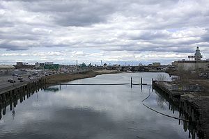
, emptying into the East River
East River
The East River is a tidal strait in New York City. It connects Upper New York Bay on its south end to Long Island Sound on its north end. It separates Long Island from the island of Manhattan and the Bronx on the North American mainland...
. The river is located in a valley that may have been a larger riverbed prior to the last Ice Age
Wisconsin glaciation
The last glacial period was the most recent glacial period within the current ice age occurring during the last years of the Pleistocene, from approximately 110,000 to 10,000 years ago....
, neatly dividing Queens into a western and an eastern half.
The Channel
The headwaters of Flushing Creek were once located in the present-day neighborhood of Kew Gardens HillsKew Gardens Hills, Queens
Kew Gardens Hills, also sometimes incorrectly referred to as Kew Garden Hills, is a one-square mile sub-neighborhood of Flushing in the New York City borough of Queens. The western border is Flushing Meadows-Corona Park, on the north is Jewel Avenue, on the south is Union Turnpike and to the east...
, where Vleigh Place traces the Vleigh (old Dutch for Valley) of the headwaters. In the larger valley that comprises the present-day Flushing Meadows-Corona Park
Flushing Meadows-Corona Park
Flushing Meadows-Corona Park, often referred to as Flushing Meadow Park, Flushing Meadows Park or Flushing Meadows, is a public park in New York City. It contains the USTA Billie Jean King National Tennis Center, the current venue for the U.S...
, the creek meandered through salt marshes, collecting water from Fly and Ireland Creeks and Horse Brook before emptying into Flushing Bay on the East River. The area near the mouth of the creek became the site of the early Flushing
Flushing, Queens
Flushing, founded in 1645, is a neighborhood in the north central part of the City of New York borough of Queens, east of Manhattan.Flushing was one of the first Dutch settlements on Long Island. Today, it is one of the largest and most diverse neighborhoods in New York City...
settlement.
History
The town of FlushingFlushing, Queens
Flushing, founded in 1645, is a neighborhood in the north central part of the City of New York borough of Queens, east of Manhattan.Flushing was one of the first Dutch settlements on Long Island. Today, it is one of the largest and most diverse neighborhoods in New York City...
was first settled in 1645 under charter of the Dutch West India Company
Dutch West India Company
Dutch West India Company was a chartered company of Dutch merchants. Among its founding fathers was Willem Usselincx...
and was named after the port of Vlissingen, in the southwestern Netherlands. It is said that the name Vlissingen means "salt meadow," given as a nod to the tidal waters of Flushing Meadows. As the English version of the name of the Dutch town is "Flushing", the same English version was used by the town's English-speaking inhabitants. During his presidency, George Washington
George Washington
George Washington was the dominant military and political leader of the new United States of America from 1775 to 1799. He led the American victory over Great Britain in the American Revolutionary War as commander-in-chief of the Continental Army from 1775 to 1783, and presided over the writing of...
arrived to Flushing by ferry across. The first road crossing, a drawbridge at Northern Boulevard
New York State Route 25A
New York State Route 25A is a state highway on Long Island in New York in the United States. It serves as the main east–west route for most of the North Shore of Long Island, running from the Queens Midtown Tunnel in the New York City borough of Queens at its western terminus to...
, was built in the early 19th century.
By the 1850s, a second crossing, Strong's Causeway was built near the present-day Long Island Expressway, extending Corona Avenue towards Flushing. This crossing was located near the confluence of Horse Brook and Flushing Creek. In the mid-19th Century, the growing city of Brooklyn acquired the land around the creek and gave it for use to the Brooklyn Ash Removal Company, which turned the salt marshes into landfill. The pollution was chronicled by F. Scott Fitzgerald
F. Scott Fitzgerald
Francis Scott Key Fitzgerald was an American author of novels and short stories, whose works are the paradigm writings of the Jazz Age, a term he coined himself. He is widely regarded as one of the greatest American writers of the 20th century. Fitzgerald is considered a member of the "Lost...
in The Great Gatsby
The Great Gatsby
The Great Gatsby is a novel by the American author F. Scott Fitzgerald. First published in1925, it is set on Long Island's North Shore and in New York City from spring to autumn of 1922....
, where Nick Carraway observed the "valley of ashes" on his train ride between Manhattan and Long Island.
In 1936, Robert Moses
Robert Moses
Robert Moses was the "master builder" of mid-20th century New York City, Long Island, Rockland County, and Westchester County, New York. As the shaper of a modern city, he is sometimes compared to Baron Haussmann of Second Empire Paris, and is one of the most polarizing figures in the history of...
proposed closing the ash landfill and transforming it into a park through its use as a World's Fair site. With the exception of the Willets Point triangle, the landfill was leveled, the creek bed was straightened, and the southern part of the creek was deepened to form the Meadow and Willow lakes. At its northern section, a tidal gate bridge was built to keep the East River tide from flooding into the park. By then, Horse Brook was long gone, covered by the future Long Island Expressway. Ireland Creek was also filled in for use as parkland
Kissena Park
Kissena Park is a large park located in the neighborhood of Flushing in the New York City borough of Queens, along Kissena Creek which formerly flowed into the Flushing River. It is bordered on the west by Kissena Boulevard; on the north by Rose, Oak, Underhill, and Lithonia Avenues; on the east...
to prevent flooding in the surrounding neighborhoods. Dammed and reduced in size, the creek became navigable only up to Roosevelt Avenue
Roosevelt Avenue
Roosevelt Avenue is a main thoroughfare in the New York City borough of Queens. Roosevelt Avenue begins at 48th Street and Queens Boulevard in the neighborhood of Sunnyside...
. Barges still docked on the river, bringing sand and gravel. At its southern end, the Jamaica subway yard reduced some of the flow coming from the headwaters.
For the 1964 World's Fair, the creek was further reduced, when its middle section was filled in for parkland. Flowing out of Meadow Lake, the creek was reduced to a canal beneath the Van Wyck Expressway, narrowing into pipes going into the Fountain of the Planets, a circular pool used for fountain displays. From there, the pipes took the water towards the tidal bridge, reemerging as a creek.
Over the years, pollution from the Willets Point
Willets Point, Queens
Willets Point, also known locally as the Iron Triangle, is the name currently applied to a neighborhood of Corona, in the New York City borough of Queens....
industrial area, surrounding highways, and dumping made the river an eyesore and a health hazard. In 2002, a sewage treatment plant was completed near College Point Boulevard, and the city took stronger enforcement measures against industries in Willets Point.
Restoring the River
As other waterways in New York have seen their shores revitalized with parks, the middle 20th century waterfront promenade along Flushing Bay to LaGuardia AirportLaGuardia Airport
LaGuardia Airport is an airport located in the northern part of Queens County on Long Island in the City of New York. The airport is located on the waterfront of Flushing Bay and Bowery Bay, and borders the neighborhoods of Astoria, Jackson Heights and East Elmhurst. The airport was originally...
was given a renovation and reopened in 2001. The success of this project led to calls for a similar waterfront promenade less than a mile upstream near downtown Flushing. There are also ongoing plans by the city to raze Willets Point
Willets Point, Queens
Willets Point, also known locally as the Iron Triangle, is the name currently applied to a neighborhood of Corona, in the New York City borough of Queens....
in favor of a convention center and hotels.
Among the more ambitious proposals include reopening the buried parts of Flushing Creek to daylight
Daylighting (streams)
In urban design and urban planning, daylighting is the redirection of a stream into an above-ground channel. Typically, the goal is to restore a stream of water to a more natural state...
, which would mean closing two soccer fields, and altering the park's golf course. At Meadow Lake, the abandoned Aquacade arena from the 1939 World's Fair has been demolished in favor of a pier with a sitting area, however the boathouse is still in use. At the creek's source, Willow Lake, nature trails paved decades ago remain overgrown with plants, and are currently closed to the public.
2012 Olympic Proposal
The New York City 2012 Olympic bidNew York City 2012 Olympic bid
The New York City 2012 Olympic bid was one of the five short-listed bids for the 2012 Summer Olympics, ultimately won by London 2012.New York City's Olympic Bid, run by the private non-profit organization NYC2012, was founded by Daniel L. Doctoroff, who was managing director of a successful private...
proposed merging the two lakes, with a new bridge at Jewel Avenue. The proposal generated community opposition, citing aesthetics in the proposed lake's rectagular shape; traffic and lack of public access during the games, loss of parkland, and disruption to wildlife living in Willow Lake. Failing to secure its bid, the city has since shelved plans to unite the lakes.