

Florida State Road 211
Encyclopedia
State Road 211 is a state highway
entirely within Jacksonville, Florida
, running from U.S. Highway 17/SR 15 (Roosevelt Boulevard
), north to the northern approach of the Acosta Bridge at SR 13 with US 17/SR 15 and SR 228
in downtown Jacksonville.
 State Road 211 begins at an intersection with U.S. Highway 17/SR 15
(Roosevelt Boulevard
) and proceeds north as Ortega Boulevard, a one lane street through residential areas. It veers one block west of the St. Johns River
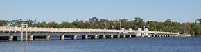
through the neighborhood, heading towards a northeast direction until an intersection with Grand Avenue, where SR 211 heads in a northwest direction as Grand Avenue. Three blocks northwest of the intersection, SR 211 crosses the Old Ortega River Bridge, a drawbridge over the St. Johns River. At the northern end of the bridge, SR 211 heads west as San Juan Avenue, passing by a park and more residential housing. At Herschel Street, SR 128 begins westbound as San Juan Avenue, while SR 211 heads north as Herschel Street, becoming a bit more of a commercial street, with residential housing not far from the road. After a short crossing of a canal, the road turns east, becoming St. Johns Avenue and once again, paralleling the St. Johns River as SR 211 enters Avondale, a residential district. After curving in direction for a few blocks, St. Johns Avenue gains a parallel street, Riverside Avenue, one block northeast of St. Johns Avenue, with SR 211 representing a mix of residential and commercial areas as it heads northeast. At the western end of the St. Vincents Medical Center, SR 211 turns north on King Street for one block, which at one point represented the city limits of Jacksonville. SR 211 then turns east on Riverside Avenue, which paralleled St. Johns Avenue for 19 blocks to the southwest, into the Riverside area, continuing the mix of commercial and residential presence on SR 211. After a few blocks, it turns north, with intersections with Post Street, the historical northern terminus of SR 211, and I-95
two blocks north, in which access is provided a few blocks north on Park Street. SR 211 goes under I-95, entering central Jacksonville, and becoming a divided road with two lanes each way, quickly approaching the northern approach of the Acosta Bridge
, where SR 211 ends at the intersection with US 17/SR 13/SR 228 in central Jacksonville.
, before Roosevelt Avenue (now Roosevelt Boulevard
) was built. Between 1951 - 1955, the route was signed "US Alt 17", with a hidden State Road 211. By 1957, the US Alt 17 was removed and it was only signed as State Road 211. The portion between Post Street north to the Acosta Bridge was added to SR 211 in 1994.
, Duval County
.
State highway
State highway, state road or state route can refer to one of three related concepts, two of them related to a state or provincial government in a country that is divided into states or provinces :#A...
entirely within Jacksonville, Florida
Jacksonville, Florida
Jacksonville is the largest city in the U.S. state of Florida in terms of both population and land area, and the largest city by area in the contiguous United States. It is the county seat of Duval County, with which the city government consolidated in 1968...
, running from U.S. Highway 17/SR 15 (Roosevelt Boulevard
Roosevelt Boulevard (Jacksonville)
Roosevelt Boulevard is a six lane highway on the west side of Jacksonville, Florida. It takes US 17 and SR 15, from the Duval county line just south Interstate 295, until its northern end at Willow Branch Avenue, with the road itself becoming one of the incarnations of College Street in the...
), north to the northern approach of the Acosta Bridge at SR 13 with US 17/SR 15 and SR 228
State Road 228 (Florida)
State Road 228 is a state highway in the U.S. state of Florida. It runs from U.S. Highway 301 at Maxville east to downtown Jacksonville via Normandy Blvd. At SR 111 , it changes to Post St, connecting U.S. Highway 17/SR 15 where it proceeds to North via SR 211 Riverside Ave East on Bay St,...
in downtown Jacksonville.
Route description
State Road 15 (Florida)
State Road 15 is part of the Florida State Road System. It runs from SR 80/SR 880 at Belle Glade north along the east shore of Lake Okeechobee to Okeechobee. Then it runs north to SR 500 at Holopaw, and northwest along SR 500 to Ashton State Road 15 (commonly SR 15) is part of the Florida State...
(Roosevelt Boulevard
Roosevelt Boulevard (Jacksonville)
Roosevelt Boulevard is a six lane highway on the west side of Jacksonville, Florida. It takes US 17 and SR 15, from the Duval county line just south Interstate 295, until its northern end at Willow Branch Avenue, with the road itself becoming one of the incarnations of College Street in the...
) and proceeds north as Ortega Boulevard, a one lane street through residential areas. It veers one block west of the St. Johns River
St. Johns River
The St. Johns River is the longest river in the U.S. state of Florida and its most significant for commercial and recreational use. At long, it winds through or borders twelve counties, three of which are the state's largest. The drop in elevation from the headwaters to the mouth is less than ;...
through the neighborhood, heading towards a northeast direction until an intersection with Grand Avenue, where SR 211 heads in a northwest direction as Grand Avenue. Three blocks northwest of the intersection, SR 211 crosses the Old Ortega River Bridge, a drawbridge over the St. Johns River. At the northern end of the bridge, SR 211 heads west as San Juan Avenue, passing by a park and more residential housing. At Herschel Street, SR 128 begins westbound as San Juan Avenue, while SR 211 heads north as Herschel Street, becoming a bit more of a commercial street, with residential housing not far from the road. After a short crossing of a canal, the road turns east, becoming St. Johns Avenue and once again, paralleling the St. Johns River as SR 211 enters Avondale, a residential district. After curving in direction for a few blocks, St. Johns Avenue gains a parallel street, Riverside Avenue, one block northeast of St. Johns Avenue, with SR 211 representing a mix of residential and commercial areas as it heads northeast. At the western end of the St. Vincents Medical Center, SR 211 turns north on King Street for one block, which at one point represented the city limits of Jacksonville. SR 211 then turns east on Riverside Avenue, which paralleled St. Johns Avenue for 19 blocks to the southwest, into the Riverside area, continuing the mix of commercial and residential presence on SR 211. After a few blocks, it turns north, with intersections with Post Street, the historical northern terminus of SR 211, and I-95
Interstate 95 in Florida
Interstate 95 is the main Interstate Highway on the east coast of the United States; it serves the Atlantic coast of Florida. It begins at a partial interchange with U.S. Highway 1 just south of downtown Miami, and heads north past Daytona Beach and Jacksonville to the Georgia state line at the St...
two blocks north, in which access is provided a few blocks north on Park Street. SR 211 goes under I-95, entering central Jacksonville, and becoming a divided road with two lanes each way, quickly approaching the northern approach of the Acosta Bridge
Acosta Bridge
The Acosta Bridge spans the St. Johns River in Jacksonville, Florida on a fixed span. It was named for City Councilman St. Elmo W. Acosta, who convinced voters to approve a $950,000 bond issue for the original bridge. It carries SR 13 with the two-track JTA Skyway in the median. Prior to its...
, where SR 211 ends at the intersection with US 17/SR 13/SR 228 in central Jacksonville.
History
From 1932 to 1950, the road was the original route in south Jacksonville of US 17U.S. Route 17 in Florida
U.S. Route 17 in Florida is a north–south United States Highway. It runs from the Punta Gorda, Florida Metropolitan Statistical Area northeast to the Greater Jacksonville Metropolitan Area....
, before Roosevelt Avenue (now Roosevelt Boulevard
Roosevelt Boulevard (Jacksonville)
Roosevelt Boulevard is a six lane highway on the west side of Jacksonville, Florida. It takes US 17 and SR 15, from the Duval county line just south Interstate 295, until its northern end at Willow Branch Avenue, with the road itself becoming one of the incarnations of College Street in the...
) was built. Between 1951 - 1955, the route was signed "US Alt 17", with a hidden State Road 211. By 1957, the US Alt 17 was removed and it was only signed as State Road 211. The portion between Post Street north to the Acosta Bridge was added to SR 211 in 1994.
Major junctions
The entire route is located in JacksonvilleJacksonville, Florida
Jacksonville is the largest city in the U.S. state of Florida in terms of both population and land area, and the largest city by area in the contiguous United States. It is the county seat of Duval County, with which the city government consolidated in 1968...
, Duval County
Duval County, Florida
Duval County is a county located in the U.S. state of Florida. As of 2010, the population was 864,263. Its county seat is Jacksonville, with which the Duval County government has been consolidated since 1968...
.
| Mile | Destinations | Notes |
|---|---|---|
| 0.0 | Southern terminus | |
| Ortega River Bridge over St. Johns River | ||
| 3.1 | /Herschel Street | Eastern terminus of SR 128 |
| 6.8 | Access via Park Street | |
| 7.7 | Northern terminus | |