
Fingal Head, New South Wales
Encyclopedia
James Cook
Captain James Cook, FRS, RN was a British explorer, navigator and cartographer who ultimately rose to the rank of captain in the Royal Navy...
about 17:15 EST 15–16 May 1770 (log date). The area and small town is often just called Fingal. It is located on the Far North Coast of New South Wales
New South Wales
New South Wales is a state of :Australia, located in the east of the country. It is bordered by Queensland, Victoria and South Australia to the north, south and west respectively. To the east, the state is bordered by the Tasman Sea, which forms part of the Pacific Ocean. New South Wales...
in Tweed Shire, about 5 km south of the New South Wales and Queensland border, and south of the Gold Coast
Queensland
Queensland is a state of Australia, occupying the north-eastern section of the mainland continent. It is bordered by the Northern Territory, South Australia and New South Wales to the west, south-west and south respectively. To the east, Queensland is bordered by the Coral Sea and Pacific Ocean...
. At the 2006 census
Census in Australia
The Australian census is administered once every five years by the Australian Bureau of Statistics. The most recent census was conducted on 9 August 2011; the next will be conducted in 2016. Prior to the introduction of regular censuses in 1961, they had also been run in 1901, 1911, 1921, 1933,...
, Fingal Head had a population of 575 people.
Geography
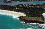
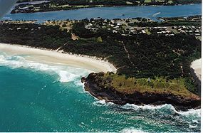
The Tweed River, (discovered by John Oxley in October 1823) on the north coast of New South Wales runs northwards close to the coast for about 6 km before reaching its mouth just south of present day Point Danger. A spit about 500–800 metres wide called "Letitia Spit" (named after the first ship to enter the river in July 1840) runs south for 2 km to Fingal Head.The headland itself was made form the magma flow from the extinct volcano, Mount Warning
Mount Warning
Mount Warning is a mountain west-south-west of Murwillumbah, near the border with Queensland in the Northern Rivers region of New South Wales, Australia...
. There are walking tracks all over this area. About 500 metres offshore from the headland is Cook Island, a rocky uninhabited island first charted by James Cook in 1770. The stretch of water to the island is called the "Giants Causeway". Cook Island was made a marine reserve in 1998.
Fishing is prohibited in the waters nearby.
History
There has been controversy over the naming of Fingal Head by James Cook in May 1770 for many years. Strong evidence suggests that Fingal Head was in fact; the point, James Cook named Point Danger.In 1823 John Oxley
John Oxley
John Joseph William Molesworth Oxley was an explorer and surveyor of Australia in the early period of English colonisation.October 1802 he was engaged in coastal survey work including an expedition to Western Port in 1804-05...
took shelter from Southerly winds, while sailing North near Point Lookout
Point Lookout, New South Wales
Point Lookout is the name of a mountain in the New England National Park, near Ebor, Australia.It is the second highest peak in the Snowy Range, a spur of the Great Dividing Range which forms the highest part, and eastern edge of the Northern Tablelands...
...under the lee of the Island in 7 fms. sandy bottom. [Before anchoring we] passed close to a Bold Headland about 3 Miles North of Pt.D. (Point Danger) On the South Side of this headland we had the satisfaction to discover a considerable river... (Tweed RiverTweed River (New South Wales)The Tweed River is a short river in the Northern Rivers region of New South Wales, Australia. Its drainage basin consists mostly of the erosion caldera of the Tweed Volcano, a huge extinct volcano of which Mount Warning is the volcanic plug...
)
John Uniack and later Oxley went onto the island, where they found some sea turtle
Sea turtle
Sea turtles are marine reptiles that inhabit all of the world's oceans except the Arctic.-Distribution:...
s and called the island "Turtle Island". In 1828 Henry John Rous (Captain of HMS Rainbow) surveyed Oxley's Tweed River
Tweed River (New South Wales)
The Tweed River is a short river in the Northern Rivers region of New South Wales, Australia. Its drainage basin consists mostly of the erosion caldera of the Tweed Volcano, a huge extinct volcano of which Mount Warning is the volcanic plug...
, the name used today. A chart published in 1831 by the Master of the "Rainbow" showing the island as "Cook's Isle" and the river named the "Clarance River" - the unnamed headland, North of the river was named Point Danger. However the off-shore reefs East of the Island where not marked.
The local aboriginal
Indigenous Australians
Indigenous Australians are the original inhabitants of the Australian continent and nearby islands. The Aboriginal Indigenous Australians migrated from the Indian continent around 75,000 to 100,000 years ago....
people were the Minjungbal, but the impact of white settlement meant they almost became wiped out by 1900.
Fingal Head Post Office opened on 15 March 1912, uprated from a telegraph office opened in October 1911.
Lighthouse
A provisional light station was established on the head in 1872 and in 1878 a proper lighthouse, built as a sandstone construction in a round design, was inaugurated. It was part of a series of five such lighthouses established between 1878 and 1880. The tower only stands 7 metres high, but that suffices since the headland itself adds additional height. Thus the focal plane of the lightsource is situated at 24 m above sea level. In 1920 the lightsource was changed from keroseneKerosene
Kerosene, sometimes spelled kerosine in scientific and industrial usage, also known as paraffin or paraffin oil in the United Kingdom, Hong Kong, Ireland and South Africa, is a combustible hydrocarbon liquid. The name is derived from Greek keros...
to acetylene
Acetylene
Acetylene is the chemical compound with the formula C2H2. It is a hydrocarbon and the simplest alkyne. This colorless gas is widely used as a fuel and a chemical building block. It is unstable in pure form and thus is usually handled as a solution.As an alkyne, acetylene is unsaturated because...
and became automated. It was electrified in 1980. The light characteristic is a single flash every five seconds. Depending on the bearing
Bearing (navigation)
In marine navigation, a bearing is the direction one object is from another object, usually, the direction of an object from one's own vessel. In aircraft navigation, a bearing is the actual compass direction of the forward course of the aircraft...
, red light is shown in the east sector while the other sectors show white.
Surfing
Since 1996 Fingal has hosted an annual surfingSurfing
Surfing' is a surface water sport in which the surfer rides a surfboard on the crest and face of a wave which is carrying the surfer towards the shore...
competition for indigenous
Indigenous Australians
Indigenous Australians are the original inhabitants of the Australian continent and nearby islands. The Aboriginal Indigenous Australians migrated from the Indian continent around 75,000 to 100,000 years ago....
surfers. The first year attracted 90 surfers from across Australia. In 1999, SBS television
Special Broadcasting Service
The Special Broadcasting Service is a hybrid-funded Australian public broadcasting radio and television network. The stated purpose of SBS is "to provide multilingual and multicultural radio and television services that inform, educate and entertain all Australians and, in doing so, reflect...
commissioned a documentary called Surfing the Healing Wave about that competition, as part of an Unfinished Business - Reconciling the Nation series. It won Best Australian Documentary at the 2000 Real Life on Film Festival.
Fingal is not particularly noted as a surf spot as such. The headland does not form a point break on either side, so it is just beach breaks that occur there, but the southern side is one of the few places near the Gold Coast
Gold Coast, Queensland
Gold Coast is a coastal city of Australia located in South East Queensland, 94km south of the state capital Brisbane. With a population approximately 540,000 in 2010, it is the second most populous city in the state, the sixth most populous city in the country, and also the most populous...
with any protection from northerly winds.
External links
- Fingal Head page at Geoscience AustraliaGeoscience AustraliaGeoscience Australia is an agency of the Australian federal government. It carries out geoscientific research.On a user pays basis it produces geospatial products such as topographic maps and satellite imagery.-History:...
- UBD Brisbane Street Directory, 1992, ISBN 0-7319-0415-X.
- Fingal Head travel, in The AgeThe AgeThe Age is a daily broadsheet newspaper, which has been published in Melbourne, Australia since 1854. Owned and published by Fairfax Media, The Age primarily serves Victoria, but is also available for purchase in Tasmania, the Australian Capital Territory and border regions of South Australia and...
newspaper 8 February 2004