
Fay hut
Encyclopedia
The Fay hut was an alpine hut located above Prospectors Valley in Kootenay National Park
, British Columbia
. Although the higher Neil Colgan hut
superseded it as a base for climbs in the Valley of the Ten Peaks
area, it still served as a convenient base for hikers
and skiers
doing day trips in the area, and as an overnight stop for mountaineers
continuing on to the Neil Colgan hut. A new hut was built in 2005 to replace the original Fay hut, which was destroyed by a forest fire in 2003. The Fay hut was maintained by the Alpine Club of Canada
(ACC).
The new Fay Hut burned down in April 2009 due to unknown reasons. All that was left of it was the metal from the roof, lying on the ground. The hut was not insured, so it is questionable whether it will be rebuilt again.
 The original Fay hut was built in 1927 as a base for climbing in the Valley of the Ten Peaks
area. Although it was predated by the Abbot Pass hut
and the Elizabeth Parker hut
, it was the first hut actually built by the Alpine Club of Canada
(ACC). The other two huts were built by the Canadian Pacific Railway
and turned over to the ACC some time later. The Fay hut was named for Charles Fay
, a founder and the first president of the American Alpine Club
. Charles Fay made 25 trips to the Canadian Rockies
, participated in the first ascents of Mounts Victoria and Lefroy, and was an honorary member of the ACC.
 The ACC operated the hut until 1972, when it turned it over to Kootenay National Park
because it could not afford to pay for repairs after a tree fell through the roof. The Park operated it until 1991 when, in a reversal of philosophy, it returned it to the ACC because it did not want to pay for renovations to keep it operating. The ACC and its Rocky Mountain Section put a major effort into renovations and returned the hut to excellent condition.
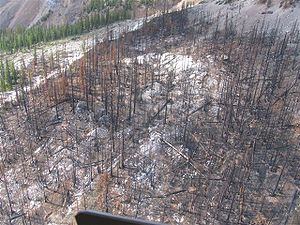
The original Fay hut was destroyed in 2003 by a major forest fire
that burned 12.6% of Kootenay National Park.
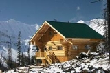
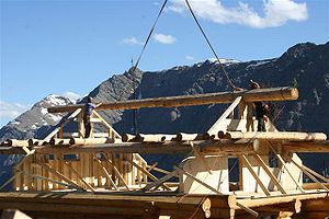
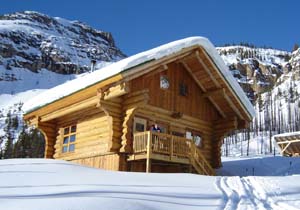
The current Fay hut was rebuilt by the ACC in 2005, close to the site of the original hut. Construction involved the contribution of hundreds of thousands of dollars, and thousands of hours of volunteer time, by the members of the ACC and its Rocky Mountain Section. The new hut was a modern log building
, prefabricated
outside of the park and airlifted to the site in 140 loads by two Bell 407
helicopters in June and July 2005. 20 volunteers a week worked on site for 4 weeks in July, 2005 to assemble the structure. There was one further week of work done in 2006 to finish some small items not completed the year before. In June 2005 85 flights were made to load most of the materials needed to complete the project. This was completed by several volunteers over a four day period. In order for the actual construction to begin the site had to be cleared, a bridge built and a helicopter landing pad constructed.
In 2009, the new hut burned to the ground while it was unoccupied, sometime between the morning of April 2, when the last group to stay there left, and the evening of April 4, when the next group arrived. With no accommodation, the incoming group had to ski 14 kilometres (8.7 mi) back to the parking lot, arriving there at midnight. Only metal objects remained of the structure, as all the combustibles were consumed by the fire, leaving the metal roof lying on the ground. An investigation determined that the fire started at the point where the fireplace chimney went through the log cabin roof. The fire most likely occurred as the result of the ignition of the roof beams caused by leaking hot gases from the fireplace. The most probable cause of the wood becoming heated is that snow creep might have pushed open the joints of the chimney pipe. The hut was uninsured and no decision has been made by the Alpine Club whether to rebuilt it or not.
}
|-
| Elevation gain || 600 metres (1,968.5 ft)
|-
| Approximate time || 4–5 hours in summer / 5–11 hours in winter
|}
In both summer and winter, start from the Marble Canyon parking lot 6.5 kilometres (4 mi) west of the Alberta
border on British Columbia Highway 93 (the Banff-Radium Hiqhway).
In summer, follow the well-marked trail along Tokumm Creek for about 10 kilometres (6.2 mi) and then turn right at the trail sign indicating the route to the hut. The trail gains elevation and after about 1.5 km (0.93205910497471 mi) ascends a 50 m (164 ft) high rocky headwall. A rope hanging from the top of the headwall provides some help. The hut is only a few hundred metres east of the top of the rope. Note that the trail gains 450 of the 600 metres of elevation in the last 2 kilometres. The route should take about 4–5 hours.
In winter, the trail follows the same route, but route-finding after leaving Tokumm Creek can be difficult. After crossing the small bridge at 10 kilometres (6.2 mi), watch for the signpost directing you into a drainage to the east. Head along the small creek for about 50 metres (164 ft) and, after encountering a small ice wall on the right, start the climb up. There is a fixed rope to help with a short section, although it may be buried by snow. At the top, the hut is a few hundred metres to the right, but without a defined trail or a GPS
you may have trouble finding it. This route should take about 5 hours, but may take up to 11 if trail breaking is required, and many groups have had to bivy overnight
near the headwall.
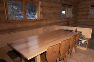
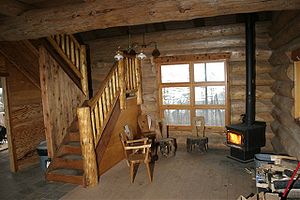 The hut sleeps 12 in summer or winter on foam mattresses. It is equipped with both solar lighting
and propane
powered lamps
. It has a propane stovetop and oven
, and a wood-burning stove
for heating in the winter.
in the Valley of the Ten Peaks
area, but has since been superseded for that purpose by the Neil Colgan hut
. However, it is still possible to make ascents in this area using Fay hut as a base, and peaks like Mount Little, Mount Fay, and Mount Quadra are the most common.
For hiking
and backcountry skiing
, the trip up Tokumm Creek itself is worthwhile and highly scenic. Continuing along the trail past the turnoff to the hut to the Kaufmann Lake junction is also a good objective, but as of 2007, the trail past the turnoff had not been cleared of deadfall from the forest fire. Skiing from the Fay hut to the Neil Colgan hut is also possible, but should be considered ski mountaineering
and can be challenging if conditions are not ideal.
. All vehicles stopping in a National Park must have a Park Motor Vehicle Permit. Annual or single day permits can be purchased at most Park entrance gates and Park visitor centres.
Banff, Jasper, Kootenay, Yoho, and Glacier National Parks collect a fee for backcountry overnight use in the Parks. The fees collected from the wilderness passes go towards maintaining trails, supplying the voluntary registration service, avalanche forecasting, backcountry bridge-building, etc. Overnight users of the Fay hut (ages 16 and over) are required to pay this fee.
The maximum group size for hiking is 10 persons. If your group is larger, you will need to split into smaller groups.
Natural hazards are part of every visit to the Rocky Mountains. It is recommended that anyone participating in hazardous activities in the backcountry register with the Park Wardens. This registration is free and is the best method of ensuring that someone comes looking for you should the worst happen. You can register at any Parks Canada Visitor Centre.
This map shows the trails and highlights of the area. The hut is located at grid reference 552793 For the trail along Tokumm Creek, but not really necessary.
Kootenay National Park
Kootenay National Park is located in southeastern British Columbia Canada covering in the Canadian Rockies and forms part of a World Heritage Site. The park ranges in elevation from at the south-west park entrance to at Deltaform Mountain...
, British Columbia
British Columbia
British Columbia is the westernmost of Canada's provinces and is known for its natural beauty, as reflected in its Latin motto, Splendor sine occasu . Its name was chosen by Queen Victoria in 1858...
. Although the higher Neil Colgan hut
Neil Colgan Hut
The Neil Colgan Hut is an alpine hut located on the Fay Glacier in Kootenay National Park. It is situated in a col between Mount Little and Mount Bowlen, which is one of the peaks overlooking The Valley of the Ten Peaks. The hut is maintained by the Alpine Club of Canada...
superseded it as a base for climbs in the Valley of the Ten Peaks
Valley of the Ten Peaks
Valley of the Ten Peaks is a valley in Banff National Park that is crowned by ten notable peaks and also includes Moraine Lake. The valley can be reached by following the Moraine Lake road near Lake Louise...
area, it still served as a convenient base for hikers
Hiking
Hiking is an outdoor activity which consists of walking in natural environments, often in mountainous or other scenic terrain. People often hike on hiking trails. It is such a popular activity that there are numerous hiking organizations worldwide. The health benefits of different types of hiking...
and skiers
Ski touring
Ski touring is a form of backcountry skiing involving traveling over the winter landscape on skis under human power rather than through the assistance of ski lifts or snow vehicles. It can take place in terrain ranging from perfectly flat to extremely steep...
doing day trips in the area, and as an overnight stop for mountaineers
Mountaineering
Mountaineering or mountain climbing is the sport, hobby or profession of hiking, skiing, and climbing mountains. While mountaineering began as attempts to reach the highest point of unclimbed mountains it has branched into specialisations that address different aspects of the mountain and consists...
continuing on to the Neil Colgan hut. A new hut was built in 2005 to replace the original Fay hut, which was destroyed by a forest fire in 2003. The Fay hut was maintained by the Alpine Club of Canada
Alpine Club of Canada
The Alpine Club of Canada is a mountain club with a National Office in Canmore, Alberta that has been a focal point for Canadian mountaineering since its founding in 1906. The club was co-founded by Arthur Oliver Wheeler, who served as its first president, and Elizabeth Parker, a journalist for...
(ACC).
The new Fay Hut burned down in April 2009 due to unknown reasons. All that was left of it was the metal from the roof, lying on the ground. The hut was not insured, so it is questionable whether it will be rebuilt again.
History
Valley of the Ten Peaks
Valley of the Ten Peaks is a valley in Banff National Park that is crowned by ten notable peaks and also includes Moraine Lake. The valley can be reached by following the Moraine Lake road near Lake Louise...
area. Although it was predated by the Abbot Pass hut
Abbot Pass hut
The Abbot Pass hut is an alpine hut located at an altitude of 2925 metres in Abbot Pass in the Rocky Mountains in Alberta, Canada. It is nestled between Mount Victoria and Mount Lefroy, straddling the continental divide, which, in this region, defines the boundary between Banff National Park in...
and the Elizabeth Parker hut
Elizabeth Parker hut
The Elizabeth Parker hut is an alpine hut located in Yoho National Park in British Columbia at an altitude of 2040 metres in a small subalpine meadow about 500 metres west of Lake O'Hara. It is surrounded by some of the most spectacular mountain scenery in the Canadian Rockies. The hut actually...
, it was the first hut actually built by the Alpine Club of Canada
Alpine Club of Canada
The Alpine Club of Canada is a mountain club with a National Office in Canmore, Alberta that has been a focal point for Canadian mountaineering since its founding in 1906. The club was co-founded by Arthur Oliver Wheeler, who served as its first president, and Elizabeth Parker, a journalist for...
(ACC). The other two huts were built by the Canadian Pacific Railway
Canadian Pacific Railway
The Canadian Pacific Railway , formerly also known as CP Rail between 1968 and 1996, is a historic Canadian Class I railway founded in 1881 and now operated by Canadian Pacific Railway Limited, which began operations as legal owner in a corporate restructuring in 2001...
and turned over to the ACC some time later. The Fay hut was named for Charles Fay
Charles Ernest Fay
Professor Charles Ernest Fay was an American Alpinist, born at Roxbury, Massachusetts. He graduated in 1868 at Tufts College and became instructor in mathematics there in 1869, and professor of modern languages in 1871...
, a founder and the first president of the American Alpine Club
American Alpine Club
The American Alpine Club, or AAC, was founded in 1902 by Charles Ernest Fay, and is the leading national organization in the United States devoted to mountaineering, climbing, and the multitude of issues facing climbers...
. Charles Fay made 25 trips to the Canadian Rockies
Canadian Rockies
The Canadian Rockies comprise the Canadian segment of the North American Rocky Mountains range. They are the eastern part of the Canadian Cordillera, extending from the Interior Plains of Alberta to the Rocky Mountain Trench of British Columbia. The southern end borders Idaho and Montana of the USA...
, participated in the first ascents of Mounts Victoria and Lefroy, and was an honorary member of the ACC.
Kootenay National Park
Kootenay National Park is located in southeastern British Columbia Canada covering in the Canadian Rockies and forms part of a World Heritage Site. The park ranges in elevation from at the south-west park entrance to at Deltaform Mountain...
because it could not afford to pay for repairs after a tree fell through the roof. The Park operated it until 1991 when, in a reversal of philosophy, it returned it to the ACC because it did not want to pay for renovations to keep it operating. The ACC and its Rocky Mountain Section put a major effort into renovations and returned the hut to excellent condition.
The original Fay hut was destroyed in 2003 by a major forest fire
Wildfire
A wildfire is any uncontrolled fire in combustible vegetation that occurs in the countryside or a wilderness area. Other names such as brush fire, bushfire, forest fire, desert fire, grass fire, hill fire, squirrel fire, vegetation fire, veldfire, and wilkjjofire may be used to describe the same...
that burned 12.6% of Kootenay National Park.
The current Fay hut was rebuilt by the ACC in 2005, close to the site of the original hut. Construction involved the contribution of hundreds of thousands of dollars, and thousands of hours of volunteer time, by the members of the ACC and its Rocky Mountain Section. The new hut was a modern log building
Log home
A log home is structurally identical to a log cabin...
, prefabricated
Prefabrication
Prefabrication is the practice of assembling components of a structure in a factory or other manufacturing site, and transporting complete assemblies or sub-assemblies to the construction site where the structure is to be located...
outside of the park and airlifted to the site in 140 loads by two Bell 407
Bell 407
The Bell 407 is a four-blade, single-engine, civil utility helicopter; a derivative of the Bell 206L-4 LongRanger. The 407 uses the four-blade rotor with composite hub developed for the United States Army's OH-58D Kiowa Warrior instead of the two-blade, semi-rigid rotor of the 206L-4...
helicopters in June and July 2005. 20 volunteers a week worked on site for 4 weeks in July, 2005 to assemble the structure. There was one further week of work done in 2006 to finish some small items not completed the year before. In June 2005 85 flights were made to load most of the materials needed to complete the project. This was completed by several volunteers over a four day period. In order for the actual construction to begin the site had to be cleared, a bridge built and a helicopter landing pad constructed.
In 2009, the new hut burned to the ground while it was unoccupied, sometime between the morning of April 2, when the last group to stay there left, and the evening of April 4, when the next group arrived. With no accommodation, the incoming group had to ski 14 kilometres (8.7 mi) back to the parking lot, arriving there at midnight. Only metal objects remained of the structure, as all the combustibles were consumed by the fire, leaving the metal roof lying on the ground. An investigation determined that the fire started at the point where the fireplace chimney went through the log cabin roof. The fire most likely occurred as the result of the ignition of the roof beams caused by leaking hot gases from the fireplace. The most probable cause of the wood becoming heated is that snow creep might have pushed open the joints of the chimney pipe. The hut was uninsured and no decision has been made by the Alpine Club whether to rebuilt it or not.
Access
| Trailhead location | 6.5 km (4 mi) west of Alberta border on Hw 93 |
| Hiking/Skiing distance |
|-
| Elevation gain || 600 metres (1,968.5 ft)
|-
| Approximate time || 4–5 hours in summer / 5–11 hours in winter
|}
In both summer and winter, start from the Marble Canyon parking lot 6.5 kilometres (4 mi) west of the Alberta
Alberta
Alberta is a province of Canada. It had an estimated population of 3.7 million in 2010 making it the most populous of Canada's three prairie provinces...
border on British Columbia Highway 93 (the Banff-Radium Hiqhway).
In summer, follow the well-marked trail along Tokumm Creek for about 10 kilometres (6.2 mi) and then turn right at the trail sign indicating the route to the hut. The trail gains elevation and after about 1.5 km (0.93205910497471 mi) ascends a 50 m (164 ft) high rocky headwall. A rope hanging from the top of the headwall provides some help. The hut is only a few hundred metres east of the top of the rope. Note that the trail gains 450 of the 600 metres of elevation in the last 2 kilometres. The route should take about 4–5 hours.
In winter, the trail follows the same route, but route-finding after leaving Tokumm Creek can be difficult. After crossing the small bridge at 10 kilometres (6.2 mi), watch for the signpost directing you into a drainage to the east. Head along the small creek for about 50 metres (164 ft) and, after encountering a small ice wall on the right, start the climb up. There is a fixed rope to help with a short section, although it may be buried by snow. At the top, the hut is a few hundred metres to the right, but without a defined trail or a GPS
Global Positioning System
The Global Positioning System is a space-based global navigation satellite system that provides location and time information in all weather, anywhere on or near the Earth, where there is an unobstructed line of sight to four or more GPS satellites...
you may have trouble finding it. This route should take about 5 hours, but may take up to 11 if trail breaking is required, and many groups have had to bivy overnight
Bivouac sack
A bivouac sack is an extremely small, lightweight, waterproof shelter, and an alternative to traditional tent systems. It is used by climbers, mountaineers, hikers, ultralight backpackers, soldiers and minimalist campers...
near the headwall.
Facilities
| Heating | Wood stove |
| Lighting | Solar and Propane |
| Cooking | Propane oven & range, cookware, dishes & utensils provided |
| Sleeping | Dormitory style on thick foam mattresses |
| Capacity | 12 in summer and winter |
| Drinking water | From the creek (boil or filter) |
| Human Waste | Outhouse (helicoptered out) |
| Dishwater | Ground sump |
| Garbage | Pack it out |
Photovoltaics
Photovoltaics is a method of generating electrical power by converting solar radiation into direct current electricity using semiconductors that exhibit the photovoltaic effect. Photovoltaic power generation employs solar panels composed of a number of solar cells containing a photovoltaic material...
and propane
Propane
Propane is a three-carbon alkane with the molecular formula , normally a gas, but compressible to a transportable liquid. A by-product of natural gas processing and petroleum refining, it is commonly used as a fuel for engines, oxy-gas torches, barbecues, portable stoves, and residential central...
powered lamps
Gas lighting
Gas lighting is production of artificial light from combustion of a gaseous fuel, including hydrogen, methane, carbon monoxide, propane, butane, acetylene, ethylene, or natural gas. Before electricity became sufficiently widespread and economical to allow for general public use, gas was the most...
. It has a propane stovetop and oven
Oven
An oven is a thermally insulated chamber used for the heating, baking or drying of a substance. It is most commonly used for cooking. Kilns, and furnaces are special-purpose ovens...
, and a wood-burning stove
Stove
A stove is an enclosed heated space. The term is commonly taken to mean an enclosed space in which fuel is burned to provide heating, either to heat the space in which the stove is situated or to heat the stove itself, and items placed on it...
for heating in the winter.
Activities
The hut was originally built as a base for mountaineeringMountaineering
Mountaineering or mountain climbing is the sport, hobby or profession of hiking, skiing, and climbing mountains. While mountaineering began as attempts to reach the highest point of unclimbed mountains it has branched into specialisations that address different aspects of the mountain and consists...
in the Valley of the Ten Peaks
Valley of the Ten Peaks
Valley of the Ten Peaks is a valley in Banff National Park that is crowned by ten notable peaks and also includes Moraine Lake. The valley can be reached by following the Moraine Lake road near Lake Louise...
area, but has since been superseded for that purpose by the Neil Colgan hut
Neil Colgan Hut
The Neil Colgan Hut is an alpine hut located on the Fay Glacier in Kootenay National Park. It is situated in a col between Mount Little and Mount Bowlen, which is one of the peaks overlooking The Valley of the Ten Peaks. The hut is maintained by the Alpine Club of Canada...
. However, it is still possible to make ascents in this area using Fay hut as a base, and peaks like Mount Little, Mount Fay, and Mount Quadra are the most common.
For hiking
Hiking
Hiking is an outdoor activity which consists of walking in natural environments, often in mountainous or other scenic terrain. People often hike on hiking trails. It is such a popular activity that there are numerous hiking organizations worldwide. The health benefits of different types of hiking...
and backcountry skiing
Backcountry skiing
Backcountry skiing is skiing in a sparsely inhabited rural region over ungroomed and unmarked slopes or pistes, including skiing in unmarked or unpatrolled areas either within the ski resort's boundaries or in the backcountry, frequently amongst trees , usually in pursuit of fresh fallen powder...
, the trip up Tokumm Creek itself is worthwhile and highly scenic. Continuing along the trail past the turnoff to the hut to the Kaufmann Lake junction is also a good objective, but as of 2007, the trail past the turnoff had not been cleared of deadfall from the forest fire. Skiing from the Fay hut to the Neil Colgan hut is also possible, but should be considered ski mountaineering
Ski mountaineering
Ski mountaineering is form of ski touring that variously combines the sports of Telemark, Alpine, and backcountry skiing with that of mountaineering...
and can be challenging if conditions are not ideal.
Parks Canada information
Fay hut is in Kootenay National ParkKootenay National Park
Kootenay National Park is located in southeastern British Columbia Canada covering in the Canadian Rockies and forms part of a World Heritage Site. The park ranges in elevation from at the south-west park entrance to at Deltaform Mountain...
. All vehicles stopping in a National Park must have a Park Motor Vehicle Permit. Annual or single day permits can be purchased at most Park entrance gates and Park visitor centres.
Banff, Jasper, Kootenay, Yoho, and Glacier National Parks collect a fee for backcountry overnight use in the Parks. The fees collected from the wilderness passes go towards maintaining trails, supplying the voluntary registration service, avalanche forecasting, backcountry bridge-building, etc. Overnight users of the Fay hut (ages 16 and over) are required to pay this fee.
The maximum group size for hiking is 10 persons. If your group is larger, you will need to split into smaller groups.
Natural hazards are part of every visit to the Rocky Mountains. It is recommended that anyone participating in hazardous activities in the backcountry register with the Park Wardens. This registration is free and is the best method of ensuring that someone comes looking for you should the worst happen. You can register at any Parks Canada Visitor Centre.
Nearby
- Neil Colgan hutNeil Colgan HutThe Neil Colgan Hut is an alpine hut located on the Fay Glacier in Kootenay National Park. It is situated in a col between Mount Little and Mount Bowlen, which is one of the peaks overlooking The Valley of the Ten Peaks. The hut is maintained by the Alpine Club of Canada...
- Valley of the Ten PeaksValley of the Ten PeaksValley of the Ten Peaks is a valley in Banff National Park that is crowned by ten notable peaks and also includes Moraine Lake. The valley can be reached by following the Moraine Lake road near Lake Louise...
- Moraine LakeMoraine LakeMoraine Lake is a glacially-fed lake in Banff National Park, outside the Village of Lake Louise, Alberta, Canada. It is situated in the Valley of the Ten Peaks, at an elevation of approximately . The lake has a surface area of ....
- Panorama Ridge
Maps
| Map reference | 82N/8 (Lake Louise) |
| Grid reference | 552793 |
| GPS coordinates | 51° 15' 45" N, 116° 12' 29" NAD83 11U 555256 5679315 |
| Hut elevation | 2108 metres (6,916 ft) |
External links
- Fay hut at the Alpine Club of Canada
- Fay hut at bivouac.com
- Weather forecasts from Environment Canada
- Public avalanche bulletins from the Canadian Avalanche Centre
- Kootenay National Park at Parks Canada
- Google Earth Find the Fay hut at 51° 15' 45" N, 116° 12' 29" W