
Faqqua
Encyclopedia
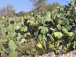
Faqqua is a village on the northern West Bank
, known for its cactus fruits
, located along the Green Line
on the Gilboa
ridge. According to the Palestinian Central Bureau of Statistics
, the town had a population of 3,490 inhabitants in mid-year 2006., an exclusively Muslim
population. The name Faqqua stems from the Arabic word `Fuqqu´, meaning mushroom. The village belongs to the Jenin district, which has been under the administration of the Palestinian Authority since 1995.
with 'K' later:faku'a
, adjacent to the green line
. Faqqua lies just below the ridge of the Gilboa
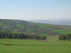
hills, which locals eponymously call Jbel Faqqua, overlooking the fertile Jezreel Valley
, known as Marj Ibn Amer in Arabic, the city of Jenin and other Palestinian villages. According to the Hebrew Bible
, Mt. Gilboa was the site where King Saul and his sons died fighting the Philistines
.
The higher part of the range, which is located on the Israel
i side, is now an area where people come to hike or to enjoy the blooming of wild flowers during springtime. The scenic view from the top is spectacular, rising to a height of 508m above the sea level, overlooking both the Jezreel valley in the west and the Israeli town of Bet She'an
and the Jordan River Valley in the east. Villagers owned 36,000 dunam
s (36 km²) land before the 1948 Arab-Israeli War
in what is today Israel.
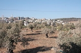
The village itself lies on a hill about 450 m above sea level. The area around Faqqua is largely rocky but there are terraces, which make it suitable for a number of trees, such as almond and olive
trees which dominate the habitat. There are also patches of small plains scattered around the area that have been utilized to grow different products such as wheat, lentils in the winter and vegetables during the summer period.
or Byzantine
presence. Roman coins have been found in the area and there are several sites that are believed to be burial grounds as well as remains of ancient olive oil production. It’s possible to find fragments of ancient pottery when simply wandering around the surrounding olive orchards. There is a common belief in local folklore that a Roman settlement once thrived nearby the current village.
families. The social structure in the village is somewhat different from a typical western community. A traditional Palestinian
village is built up by a so-called family-clan structure of a `Hamula` (clan); where social and gender relations were organized around a system of production and re-production. Even if the importance of the `Hamula` has declined immensely, the clan-structure still exists. Every ´Hamula` can be sub-divided into an ´Ayle`, an extended family. Within each ´Ayle´ there are individual families. The most important group today is, however, the ´Ayle`. There at least 15 extended families (´Ayle) in Faqqu´a today. The ten largest families are; Abu-Salameh, 'Al-Khateeb, Al-Massad', Abu-Farha, Zeidat, Jaludi, Sharafi, Abu-Nassar, Abu-Assaf and finally Abu-Hussein.
or Ramallah
where political and economical life is centred. Commuting between the regions has nevertheless become an endeavour due to the numerous Israel Defense Forces checkpoint
s.
, since high water price and the economic hardship have aggravated the water shortage even further. Faqqua's only water source is the Abu ´Ahed well in the village of Deir Ghazaleh
located about 5 kilometres away. Water is transported via tankers due to the lack of a water network.
in the area of Faqqua is a fence system that runs roughly along the Green line
, which the village straddles. The construction of the barrier, which the village was informed of in 2003 and which was completed two years later, resulted in the expropriation of 245 dunum
(0.245 km²) upon which grew 350 olive trees as well as clover and carob trees.
 The village consists of several hundred private buildings, mostly two storey, that are centred on the top of a hill. A paved road, from the foot of the hill, twists up the hillside to an intersection where residents stand in line to get to the city by taxi. A public transportation network does not exist, so the residents are dependent on the taxi-vans that run between the village and Jenin
. The ride takes about 10 minutes, but can last up to 50 minutes when checkpoints and roadblocks force detours, though this scenario has become less frequent as a result of the dismantling in 2005 of Ganim
and Kadim
in Israel's unilateral disengagement plan
.
The intersection in Faqqu´a has developed into the village's commercial centre. There are four mosques in the village, and another one is being constructed. Telephone lines are rare in the village, but most people are today owners of one or two cellular phones (Israeli and Palestinian line). There are two schools, one for boys and one for girls. The girls' school reaches the level of senior high school.
West Bank
The West Bank ) of the Jordan River is the landlocked geographical eastern part of the Palestinian territories located in Western Asia. To the west, north, and south, the West Bank shares borders with the state of Israel. To the east, across the Jordan River, lies the Hashemite Kingdom of Jordan...
, known for its cactus fruits
Opuntia
Opuntia, also known as nopales or paddle cactus , is a genus in the cactus family, Cactaceae.Currently, only prickly pears are included in this genus of about 200 species distributed throughout most of the Americas. Chollas are now separated into the genus Cylindropuntia, which some still consider...
, located along the Green Line
Green Line (Israel)
Green Line refers to the demarcation lines set out in the 1949 Armistice Agreements between Israel and its neighbours after the 1948 Arab-Israeli War...
on the Gilboa
Gilboa (ridge)
Mount Gilboa is a ridge above the Jezreel Valley in northern Israel. The formation extends from southeast to northwest, bordering the highlands of the West Bank and the Beit She'an valley. The Green Line between Israel and the West Bank runs south and west of the ridge...
ridge. According to the Palestinian Central Bureau of Statistics
Palestinian Central Bureau of Statistics
The Palestinian Central Bureau of Statistics is the statistical organization under the umbrella of the Palestinian Cabinet of the Palestinian National Authority....
, the town had a population of 3,490 inhabitants in mid-year 2006., an exclusively Muslim
Muslim
A Muslim, also spelled Moslem, is an adherent of Islam, a monotheistic, Abrahamic religion based on the Quran, which Muslims consider the verbatim word of God as revealed to prophet Muhammad. "Muslim" is the Arabic term for "submitter" .Muslims believe that God is one and incomparable...
population. The name Faqqua stems from the Arabic word `Fuqqu´, meaning mushroom. The village belongs to the Jenin district, which has been under the administration of the Palestinian Authority since 1995.
Name
Faqoa, Faqqua or faqu'awith 'K' later:faku'a
Geography
The village is located in the most northeastern part of the West Bank, 11 km east of the city of JeninJenin
Jenin is the largest town in the Northern West Bank, and the third largest city overall. It serves as the administrative center of the Jenin Governorate and is a major agricultural center for the surrounding towns. In 2007, the city had a population of 120,004 not including the adjacent refugee...
, adjacent to the green line
Green Line (Israel)
Green Line refers to the demarcation lines set out in the 1949 Armistice Agreements between Israel and its neighbours after the 1948 Arab-Israeli War...
. Faqqua lies just below the ridge of the Gilboa
Gilboa (ridge)
Mount Gilboa is a ridge above the Jezreel Valley in northern Israel. The formation extends from southeast to northwest, bordering the highlands of the West Bank and the Beit She'an valley. The Green Line between Israel and the West Bank runs south and west of the ridge...
hills, which locals eponymously call Jbel Faqqua, overlooking the fertile Jezreel Valley
Jezreel Valley
-Etymology:The Jezreel Valley takes its name from the ancient city of Jezreel which was located on a low hill overlooking the southern edge of the valley, though some scholars think that the name of the city originates from the name of the clan which founded it, and whose existence is mentioned in...
, known as Marj Ibn Amer in Arabic, the city of Jenin and other Palestinian villages. According to the Hebrew Bible
Hebrew Bible
The Hebrew Bible is a term used by biblical scholars outside of Judaism to refer to the Tanakh , a canonical collection of Jewish texts, and the common textual antecedent of the several canonical editions of the Christian Old Testament...
, Mt. Gilboa was the site where King Saul and his sons died fighting the Philistines
Philistines
Philistines , Pleshet or Peleset, were a people who occupied the southern coast of Canaan at the beginning of the Iron Age . According to the Bible, they ruled the five city-states of Gaza, Askelon, Ashdod, Ekron and Gath, from the Wadi Gaza in the south to the Yarqon River in the north, but with...
.
The higher part of the range, which is located on the Israel
Israel
The State of Israel is a parliamentary republic located in the Middle East, along the eastern shore of the Mediterranean Sea...
i side, is now an area where people come to hike or to enjoy the blooming of wild flowers during springtime. The scenic view from the top is spectacular, rising to a height of 508m above the sea level, overlooking both the Jezreel valley in the west and the Israeli town of Bet She'an
Bet She'an
is a city in the North District of Israel which has played an important role historically due to its geographical location at the junction of the Jordan River Valley and Jezreel Valley...
and the Jordan River Valley in the east. Villagers owned 36,000 dunam
Dunam
A dunam or dönüm, dunum, donum, dynym, dulum was a non-SI unit of land area used in the Ottoman Empire and representing the amount of land that can be plowed in a day; its value varied from 900–2500 m²...
s (36 km²) land before the 1948 Arab-Israeli War
1948 Arab-Israeli War
The 1948 Arab–Israeli War, known to Israelis as the War of Independence or War of Liberation The war commenced after the termination of the British Mandate for Palestine and the creation of an independent Israel at midnight on 14 May 1948 when, following a period of civil war, Arab armies invaded...
in what is today Israel.
The village itself lies on a hill about 450 m above sea level. The area around Faqqua is largely rocky but there are terraces, which make it suitable for a number of trees, such as almond and olive
Olive
The olive , Olea europaea), is a species of a small tree in the family Oleaceae, native to the coastal areas of the eastern Mediterranean Basin as well as northern Iran at the south end of the Caspian Sea.Its fruit, also called the olive, is of major agricultural importance in the...
trees which dominate the habitat. There are also patches of small plains scattered around the area that have been utilized to grow different products such as wheat, lentils in the winter and vegetables during the summer period.
History
The village's history is rather unknown, although there are numerous findings that reveal a presence in RomanRoman Empire
The Roman Empire was the post-Republican period of the ancient Roman civilization, characterised by an autocratic form of government and large territorial holdings in Europe and around the Mediterranean....
or Byzantine
Byzantine
Byzantine usually refers to the Roman Empire during the Middle Ages.Byzantine may also refer to:* A citizen of the Byzantine Empire, or native Greek during the Middle Ages...
presence. Roman coins have been found in the area and there are several sites that are believed to be burial grounds as well as remains of ancient olive oil production. It’s possible to find fragments of ancient pottery when simply wandering around the surrounding olive orchards. There is a common belief in local folklore that a Roman settlement once thrived nearby the current village.
Social structure
The village's 3,490 inhabitants are exclusively Muslim, in contrast to some neighboring villages which have a mixed population of both Muslim and ChristianChristian
A Christian is a person who adheres to Christianity, an Abrahamic, monotheistic religion based on the life and teachings of Jesus of Nazareth as recorded in the Canonical gospels and the letters of the New Testament...
families. The social structure in the village is somewhat different from a typical western community. A traditional Palestinian
Palestinian territories
The Palestinian territories comprise the West Bank and the Gaza Strip. Since the Palestinian Declaration of Independence in 1988, the region is today recognized by three-quarters of the world's countries as the State of Palestine or simply Palestine, although this status is not recognized by the...
village is built up by a so-called family-clan structure of a `Hamula` (clan); where social and gender relations were organized around a system of production and re-production. Even if the importance of the `Hamula` has declined immensely, the clan-structure still exists. Every ´Hamula` can be sub-divided into an ´Ayle`, an extended family. Within each ´Ayle´ there are individual families. The most important group today is, however, the ´Ayle`. There at least 15 extended families (´Ayle) in Faqqu´a today. The ten largest families are; Abu-Salameh, 'Al-Khateeb, Al-Massad', Abu-Farha, Zeidat, Jaludi, Sharafi, Abu-Nassar, Abu-Assaf and finally Abu-Hussein.
Economy
Agriculture had earlier been the prime source of income, but modernisation has seen most families survive by earning their livelihood from other sectors while farming land on afternoons and weekends. Some people are involved in construction, while other have businesses in Jenin, less than 11 kilometres from Faqqu´a. Academics, however, are more likely to find work in neighbouring cities such as NablusNablus
Nablus is a Palestinian city in the northern West Bank, approximately north of Jerusalem, with a population of 126,132. Located in a strategic position between Mount Ebal and Mount Gerizim, it is the capital of the Nablus Governorate and a Palestinian commercial and cultural center.Founded by the...
or Ramallah
Ramallah
Ramallah is a Palestinian city in the central West Bank located 10 kilometers north of Jerusalem, adjacent to al-Bireh. It currently serves as the de facto administrative capital of the Palestinian National Authority...
where political and economical life is centred. Commuting between the regions has nevertheless become an endeavour due to the numerous Israel Defense Forces checkpoint
Israel Defense Forces checkpoint
A Israel Defense Forces checkpoint, usually called an Israeli checkpoint , is a barrier erected by the Israel Defense Forces with the stated aim of enhancing the security of Israel and Israeli settlements and preventing those who wish to do harm from crossing...
s.
Water
The water conditions in Faqqu´a are similar to problems seen in other parts in the West Bank. The situation has become even worse since the start of the Al-Aqsa IntifadaAl-Aqsa Intifada
The Second Intifada, also known as the Al-Aqsa Intifada and the Oslo War, was the second Palestinian uprising, a period of intensified Palestinian-Israeli violence, which began in late September 2000...
, since high water price and the economic hardship have aggravated the water shortage even further. Faqqua's only water source is the Abu ´Ahed well in the village of Deir Ghazaleh
Deir Ghazaleh
Deir Ghazaleh is a Palestinian village in the northern West Bank, located nine kilometers northeast of Jenin in the Jenin Governorate. According to the Palestinian Central Bureau of Statistics, Deir Ghazaleh had a population of over 850 inhabitants in mid-year 2006, mostly Muslims, but has a...
located about 5 kilometres away. Water is transported via tankers due to the lack of a water network.
West Bank barrier
The Israeli West Bank barrierIsraeli West Bank barrier
The Israeli West Bank barrier is a separation barrier being constructed by the State of Israel along and within the West Bank. Upon completion, the barrier’s total length will be approximately...
in the area of Faqqua is a fence system that runs roughly along the Green line
Green Line (Israel)
Green Line refers to the demarcation lines set out in the 1949 Armistice Agreements between Israel and its neighbours after the 1948 Arab-Israeli War...
, which the village straddles. The construction of the barrier, which the village was informed of in 2003 and which was completed two years later, resulted in the expropriation of 245 dunum
Dunam
A dunam or dönüm, dunum, donum, dynym, dulum was a non-SI unit of land area used in the Ottoman Empire and representing the amount of land that can be plowed in a day; its value varied from 900–2500 m²...
(0.245 km²) upon which grew 350 olive trees as well as clover and carob trees.
Infrastructure
Jenin
Jenin is the largest town in the Northern West Bank, and the third largest city overall. It serves as the administrative center of the Jenin Governorate and is a major agricultural center for the surrounding towns. In 2007, the city had a population of 120,004 not including the adjacent refugee...
. The ride takes about 10 minutes, but can last up to 50 minutes when checkpoints and roadblocks force detours, though this scenario has become less frequent as a result of the dismantling in 2005 of Ganim
Ganim
Ganim was a village and an Israeli settlement in the northern West Bank under the administrative local government of the Shomron Regional Council....
and Kadim
Kadim
Kadim |Jugs]]) was an Israeli settlement in the northern West Bank under the administrative jurisdiction of Shomron Regional Council. In September 2005 its residents were evicted and IDF soldiers began dismantling Kadim as part of Israel's unilateral disengagement plan.-References:...
in Israel's unilateral disengagement plan
Israel's unilateral disengagement plan
Israel's unilateral disengagement plan , also known as the "Disengagement plan", "Gaza expulsion plan", and "Hitnatkut", was a proposal by Israeli Prime Minister Ariel Sharon, adopted by the government on June 6, 2004 and enacted in August 2005, to evict all Israelis from the Gaza Strip and from...
.
The intersection in Faqqu´a has developed into the village's commercial centre. There are four mosques in the village, and another one is being constructed. Telephone lines are rare in the village, but most people are today owners of one or two cellular phones (Israeli and Palestinian line). There are two schools, one for boys and one for girls. The girls' school reaches the level of senior high school.
See also
- JeninJeninJenin is the largest town in the Northern West Bank, and the third largest city overall. It serves as the administrative center of the Jenin Governorate and is a major agricultural center for the surrounding towns. In 2007, the city had a population of 120,004 not including the adjacent refugee...
- West BankWest BankThe West Bank ) of the Jordan River is the landlocked geographical eastern part of the Palestinian territories located in Western Asia. To the west, north, and south, the West Bank shares borders with the state of Israel. To the east, across the Jordan River, lies the Hashemite Kingdom of Jordan...
- Palestinian peoplePalestinian peopleThe Palestinian people, also referred to as Palestinians or Palestinian Arabs , are an Arabic-speaking people with origins in Palestine. Despite various wars and exoduses, roughly one third of the world's Palestinian population continues to reside in the area encompassing the West Bank, the Gaza...