

Extreme points of Brazil
Encyclopedia
Brazil
Brazil , officially the Federative Republic of Brazil , is the largest country in South America. It is the world's fifth largest country, both by geographical area and by population with over 192 million people...
.
Latitude and longitiude
The following points that are farther northNorth
North is a noun, adjective, or adverb indicating direction or geography.North is one of the four cardinal directions or compass points. It is the opposite of south and is perpendicular to east and west.By convention, the top side of a map is north....
, south
South
South is a noun, adjective, or adverb indicating direction or geography.South is one of the four cardinal directions or compass points. It is the opposite of north and is perpendicular to east and west.By convention, the bottom side of a map is south....
, east
East
East is a noun, adjective, or adverb indicating direction or geography.East is one of the four cardinal directions or compass points. It is the opposite of west and is perpendicular to north and south.By convention, the right side of a map is east....
or west
West
West is a noun, adjective, or adverb indicating direction or geography.West is one of the four cardinal directions or compass points. It is the opposite of east and is perpendicular to north and south.By convention, the left side of a map is west....
than any other location.
Brazil
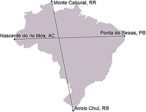
- Northernmost point: Monte CaburaíMonte CaburaíMonte Caburaí is a mountain located on the border between the South American countries of Brazil and Guyana standing at above sea level. The source of the Uailã or Ailã river, located on the mountain, is the northernmost point of Brazil....
, RoraimaRoraimaRoraima is the northernmost and least populated state of Brazil, located in the Amazon region. It borders the states of Amazonas and Pará, as well as the nations of Venezuela and Guyana. The population is 400,000 and the capital is Boa Vista...
(05°15′05"N 060°12′33"W) - Northernmost town: UiramutãUiramutãUiramutã is a municipality located in the northeast of the state of Roraima in Brazil. Its population is 7,742 and its area is 8,066 km². It is the northernmost city in Brazil, with Monte Caburaí being the northernmost point...
, RoraimaRoraimaRoraima is the northernmost and least populated state of Brazil, located in the Amazon region. It borders the states of Amazonas and Pará, as well as the nations of Venezuela and Guyana. The population is 400,000 and the capital is Boa Vista... - Southernmost point: Barra do Chuí, Rio Grande do SulRio Grande do SulRio Grande do Sul is the southernmost state in Brazil, and the state with the fifth highest Human Development Index in the country. In this state is located the southernmost city in the country, Chuí, on the border with Uruguay. In the region of Bento Gonçalves and Caxias do Sul, the largest wine...
(33°45′09"S 053°22′07"W) - Southernmost town: ChuíChui-Places:In Kyrgyzstan:*Chui Province*Chui RiverIn South America:*Chuí, Rio Grande do Sul*Chui Stream, on the Brazil-Uruguay borderIn SwahiliChui means Leopard...
, Rio Grande do SulRio Grande do SulRio Grande do Sul is the southernmost state in Brazil, and the state with the fifth highest Human Development Index in the country. In this state is located the southernmost city in the country, Chuí, on the border with Uruguay. In the region of Bento Gonçalves and Caxias do Sul, the largest wine... - Westernmost point: Serra do DivisorSerra do Divisor National ParkSerra do Divisor National Park is a national park on the westernmost point of Brazil, in the state of Acre, near Peruvian border. It is also the highest point in that state, reaching 609 meters above sea level. It has been nominated by the Brazilian government as a Tentative World Heritage Site...
, Acre (07°32′39"S 073°59′04"W) - Westernmost town: Mâncio LimaMâncio LimaMâncio Lima is the westernmost municipality of Brazil and it is located in the state of Acre. It is also the northernmost city of that state. Its population is 13,785 and its area is 4,672 km²....
, AcreAcreThe acre is a unit of area in a number of different systems, including the imperial and U.S. customary systems. The most commonly used acres today are the international acre and, in the United States, the survey acre. The most common use of the acre is to measure tracts of land.The acre is related... - Easternmost point: Ilha do Sul, Ilhas Martin Vaz, Espírito SantoEspírito SantoEspírito Santo is one of the states of southeastern Brazil, often referred to by the abbreviation "ES". Its capital is Vitória and the largest city is Vila Velha. The name of the state means literally "holy spirit" after the Holy Ghost of Christianity...
(20°28′28"S 028°50′26"W) - Easternmost town: João PessoaJoão PessoaJoão Pessoa , is the capital city of the state of Paraíba, was founded in 1585 and sometimes called the city where the sun rises first, is a Brazilian city and the easternmost city in the Americas at 34º47'38"W, 7º9'28"S. Local residents call its easternmost point Ponta do Seixas. It is also...
, ParaíbaParaíbaParaíba Paraíba Paraíba (Tupi: pa'ra a'íba: "bad to navigation"; Brazilian Portuguese pronunciation: is a state of Brazil. It is located in the Brazilian Northeast, and is bordered by Rio Grande do Norte to the north, Ceará to the west, Pernambuco to the south and the Atlantic Ocean to the east...
07°09′28"S 034°47′38"W)
Brazil (mainland)
- Northernmost point: Monte CaburaíMonte CaburaíMonte Caburaí is a mountain located on the border between the South American countries of Brazil and Guyana standing at above sea level. The source of the Uailã or Ailã river, located on the mountain, is the northernmost point of Brazil....
, RoraimaRoraimaRoraima is the northernmost and least populated state of Brazil, located in the Amazon region. It borders the states of Amazonas and Pará, as well as the nations of Venezuela and Guyana. The population is 400,000 and the capital is Boa Vista...
(05°15′05"N 060°12′33"W) - Northernmost town: UiramutãUiramutãUiramutã is a municipality located in the northeast of the state of Roraima in Brazil. Its population is 7,742 and its area is 8,066 km². It is the northernmost city in Brazil, with Monte Caburaí being the northernmost point...
, RoraimaRoraimaRoraima is the northernmost and least populated state of Brazil, located in the Amazon region. It borders the states of Amazonas and Pará, as well as the nations of Venezuela and Guyana. The population is 400,000 and the capital is Boa Vista... - Southernmost point: Barra do Chuí, Rio Grande do SulRio Grande do SulRio Grande do Sul is the southernmost state in Brazil, and the state with the fifth highest Human Development Index in the country. In this state is located the southernmost city in the country, Chuí, on the border with Uruguay. In the region of Bento Gonçalves and Caxias do Sul, the largest wine...
(33°45′09"S 053°22′07"W) - Southernmost town: ChuíChui-Places:In Kyrgyzstan:*Chui Province*Chui RiverIn South America:*Chuí, Rio Grande do Sul*Chui Stream, on the Brazil-Uruguay borderIn SwahiliChui means Leopard...
, Rio Grande do SulRio Grande do SulRio Grande do Sul is the southernmost state in Brazil, and the state with the fifth highest Human Development Index in the country. In this state is located the southernmost city in the country, Chuí, on the border with Uruguay. In the region of Bento Gonçalves and Caxias do Sul, the largest wine... - Westernmost point: Serra do DivisorSerra do Divisor National ParkSerra do Divisor National Park is a national park on the westernmost point of Brazil, in the state of Acre, near Peruvian border. It is also the highest point in that state, reaching 609 meters above sea level. It has been nominated by the Brazilian government as a Tentative World Heritage Site...
, Acre (07°32′39"S 073°59′04"W) - Westernmost town: Mâncio LimaMâncio LimaMâncio Lima is the westernmost municipality of Brazil and it is located in the state of Acre. It is also the northernmost city of that state. Its population is 13,785 and its area is 4,672 km²....
, AcreAcreThe acre is a unit of area in a number of different systems, including the imperial and U.S. customary systems. The most commonly used acres today are the international acre and, in the United States, the survey acre. The most common use of the acre is to measure tracts of land.The acre is related... - Easternmost point: Ponta do Seixas, ParaíbaParaíbaParaíba Paraíba Paraíba (Tupi: pa'ra a'íba: "bad to navigation"; Brazilian Portuguese pronunciation: is a state of Brazil. It is located in the Brazilian Northeast, and is bordered by Rio Grande do Norte to the north, Ceará to the west, Pernambuco to the south and the Atlantic Ocean to the east...
(07°09′28"S 034°47′38"W) - Easternmost town: João PessoaJoão PessoaJoão Pessoa , is the capital city of the state of Paraíba, was founded in 1585 and sometimes called the city where the sun rises first, is a Brazilian city and the easternmost city in the Americas at 34º47'38"W, 7º9'28"S. Local residents call its easternmost point Ponta do Seixas. It is also...
, ParaíbaParaíbaParaíba Paraíba Paraíba (Tupi: pa'ra a'íba: "bad to navigation"; Brazilian Portuguese pronunciation: is a state of Brazil. It is located in the Brazilian Northeast, and is bordered by Rio Grande do Norte to the north, Ceará to the west, Pernambuco to the south and the Atlantic Ocean to the east...
07°09′28"S 034°47′38"W)
Acre
- Northernmost town: Mâncio LimaMâncio LimaMâncio Lima is the westernmost municipality of Brazil and it is located in the state of Acre. It is also the northernmost city of that state. Its population is 13,785 and its area is 4,672 km²....
- Southernmost town: EpitaciolândiaEpitaciolândiaEpitaciolândia is a municipality located in the southeast of the Brazilian state of Acre. Its population is 13 434 and its area is 1,659 km². It is the southernmost municipality in Acre....
- Westernmost town: Mâncio LimaMâncio LimaMâncio Lima is the westernmost municipality of Brazil and it is located in the state of Acre. It is also the northernmost city of that state. Its population is 13,785 and its area is 4,672 km²....
- Easternmost town: AcrelândiaAcrelândiaAcrelândia is a municipality located in the easternmost portion of the Brazilian state of Acre. Its population is 8,695 and its area is 1,575 km²....
Alagoas
- Northernmost town: JacuípeJacuípeJacuípe is a municipality located in the Brazilian state of Alagoas. Its population is 7,208 and its area is 217 km²....
- Southernmost town: PiaçabuçuPiaçabuçuPiaçabuçu is a municipality located in the Brazilian state of Alagoas. It is the easternmost municipality in Alagoas, and lies near both São Francisco River and the Atlantic Ocean. Its population was 17,980 and its area is 240 km²....
- Westernmost town: Delmiro GouveiaDelmiro GouveiaDelmiro Gouveia is a municipality located in the westernmost point of the Brazilian state of Alagoas. Its population is 47,991 and its area is 609 km²....
- Easternmost town: MaragogiMaragogiMaragogi is a municipality of the Brazilian state of Alagoas in the 125 km north of Maceió capital city. Has 25,726 inhabitants, a city situated on the northern coast of Alagoas state, Brazil, being the easternmost city of that state....
Amapá
- Northernmost town: OiapoqueOiapoqueOiapoque is a municipality in the north of the state of Amapá, Brazil. Its population is 11,449 and its area is 22,625 km². Oiapoque is also a major river in the same state, forming the international border with French Guiana...
- Southernmost town: Vitória do JariVitória do JariVitória do Jari is a municipality located in the southernmost tip of the state of Amapá in Brazil. Its population is 11,253 and its area is 2,483 km²....
- Westernmost town: Laranjal do JariLaranjal do JariLaranjal do Jari is a municipality located in the west of the state of Amapá in Brazil. Its population is 39,285 and its area is 29,699 km2....
- Easternmost town: AmapáAmapá (city)Amapá is a municipality located in the easternmost portion of the state of Amapá in Brazil. Its population is 7,745 and its area is 9,169 km². The city is home to the Lago Piratuba Biological Reserve....
Amazonas
- Northernmost town: São Gabriel da CachoeiraSão Gabriel da CachoeiraSão Gabriel da Cachoeira is a city and a Municipality located on the Northern shores of the Rio Negro River, in the region of Cabeça do Cachorro, Amazonas state, Brazil. Between 1952 and 1966, it was officially called Uaupés, after the nearby Vaupés River. Most of its inhabitants are indigenous...
- Southernmost town: LábreaLábreaLábrea is the southernmost municipality in the Brazilian state of Amazonas. Its population is 38,451 and its area is 68.508,6 km². The town is the seat of the Territorial Prelature of Lábrea....
- Westernmost town: Atalaia do NorteAtalaia do NorteAtalaia do Norte is the most western municipality in the Brazilian state of Amazonas. Its population was 13,682 and its area is 76,355 km²....
- Easternmost town: NhamundáNhamundáNhamundá is the easternmost municipality in the Brazilian state of Amazonas. Its population was 18,198 and its area is 14,106 km²....
Bahia
- Northernmost town: CuraçáCuraçáCuraçá is the northernmost city in the Brazilian state of Bahia....
- Southernmost town: MucuriMucuriMucuri is a city in the state of Bahia in Brazil. The estimated population in 2008 was 34,836 inhabitants. It is the southernmost city in Bahia, and the only one from that state to border Espírito Santo....
- Westernmost town: Formosa do Rio PretoFormosa do Rio PretoFormosa do Rio Preto is the westernmost and largest city in the Brazilian state of Bahia....
- Easternmost town: JandaíraJandaíraJandaíra is the easternmost city in the Brazilian state of Bahia. The city is famous because of the Mangue seco village and beach....
Ceará
- Northernmost town: Jijoca de JericoacoaraJijoca de JericoacoaraJericoacoara is a virgin beach hidden behind the dunes of the west coast of Jijoca de Jericoacoara, Ceará, Brazil. Selected by the The Washington Post as one of the Top 10 most beautiful beaches in the world, nicknamed Jeri, consists of blue lagoons, calm seas and huge dunes.- Etymology :The name...
- Southernmost town: PenafortePenafortePenaforte is the southernmost municipality in the Brazilian state of Ceará, bordering the state of Pernambuco....
- Westernmost town: GranjaGranja, CearáGranja is the westernmost municipality in the Brazilian state of Ceará....
- Easternmost town: IcapuíIcapuíIcapuí is the easternmost municipality in the Brazilian state of Ceará, located in the northeast coast of the state....
Espírito Santo
- Northernmost town: MucuriciMucurici, Espírito SantoMucurici is the northernmost municipality in the Brazilian state of Espírito Santo. Its population was 5,914 and its area is 537.711 km².-References:...
- Southernmost town: Presidente KennedyPresidente Kennedy, Espírito SantoPresidente Kennedy is a coastal municipality located in the southernmost portion Brazilian state of Espírito Santo. Its population was 10,786 and its area is 586.464 km². It is located at 55 meters above sea level....
- Westernmost town: Dores do Rio PretoDores do Rio Preto, Espírito SantoDores do Rio Preto is the westernmost municipality in the Brazilian state of Espírito Santo. Its population was 6,288 and its area is 153.106 km². The village Pedras Meninas in Dores is the location for the entrance to Caparaó National Park and the Pico da Bandeira from Espirito...
- Easternmost town: Conceição da BarraConceição da Barra, Espírito SantoConceição da Barra is the easternmost municipality in the Brazilian state of Espírito Santo. The city is also the northernmost coastal city of the state. Its population was 27,029 and its area is 1,188.044 km².-References:...
Goiás
- Northernmost town: São Miguel do AraguaiaSão Miguel do AraguaiaSão Miguel do Araguaia is city in northeastern Goiás state, Brazil. It is the northernmost municipality in Goiás, one of the largest too, and a major producer of cattle....
- Southernmost town: ItajáItajá, GoiásItajá is a city in southwest Goiás state, Brazil. Itajá is a large producer of beef cattle.Itajá is part of the Quirinópolis Microregion. It is located eight kilometers north of the Aporá River, which forms the boundary between the states of Goiás and Mato Grosso do Sul.Itajá is 408 kilometers from...
- Westernmost town: MineirosMineirosMineiros is a city in the southwest of the state of Goiás, Brazil. Mineiros is the westernmost city in Goiás and a great producer of cattle, soybeans, and corn....
- Easternmost town: MambaíMambaíMambaí is a city in eastern Goiás state, Brazil. It is the easternmost city in that state.-Geography:Mambaí is one of the most isolated cities in the state of Goiás. It lies in the Vão do Paranã statistical micro-region less than 20 kilometers from the border with the state of Bahia. It is 61...
Maranhão
- Northernmost town: CarutaperaCarutaperaCarutapera is the northernmost city in the Brazilian state of Maranhão....
- Southernmost town: Alto ParnaíbaAlto ParnaíbaAlto Parnaíba is a Brazilian municipality in the southernmost tip of the state of Maranhão. In 2008, the city's population was 10,606....
- Westernmost town: São Pedro da Água BrancaSão Pedro da Água BrancaSão Pedro da Água Branca is the westernmost municipality in the Brazilian state of Maranhão, bordering both Pará and Tocantins states....
- Easternmost town: AraiosesAraiosesAraioses is the easternmost city in the Brazilian state of Maranhão. It lies near the Parnaíba River's delta, and its territory also include the Canárias, Desgraça, Coroatá and Grande de Paulino islands, apart from several smaller islands....
Mato Grosso
- Northernmost town: ApiacásApiacásApiacás is the northernmost municipality in the Brazilian state of Mato Grosso. It is the only city in a territorial "edge" of Mato Grosso that "pierce" the boundary between Amazonas and Pará....
- Southernmost town: Alto TaquariAlto TaquariAlto Taquari is the southernmost municipality in the Brazilian state of Mato Grosso....
- Westernmost town: ColnizaColnizaColniza is an agricultural municipality in the Brazilian state of Mato Grosso. It has the highest homicide rate in Brazil , 165 deaths per year per 100 thousand inhabitants , and is also the westernmost municipality of the state...
- Easternmost town: Santa TerezinhaSanta TerezinhaSanta Terezinha is the easternmost municipality in the Brazilian state of Mato Grosso....
Mato Grosso do Sul
- Northernmost town: CorumbáCorumbáCorumbá is a municipality in the Brazilian state of Mato Grosso do Sul, 425 km northwest of Campo Grande, the state's capital. It has a population of approximately 96,000 inhabitants, and its economy is based mainly on agriculture, animal husbandry, mineral extraction, and tourism, being the...
- Southernmost town: Mundo NovoMundo Novo, Mato Grosso do SulMundo Novo is the southernmost municipality in the Brazilian state of Mato Grosso do Sul. Its population was 16,441 and its area is 479.327 km²....
- Westernmost town: CorumbáCorumbáCorumbá is a municipality in the Brazilian state of Mato Grosso do Sul, 425 km northwest of Campo Grande, the state's capital. It has a population of approximately 96,000 inhabitants, and its economy is based mainly on agriculture, animal husbandry, mineral extraction, and tourism, being the...
- Easternmost town: ParanaíbaParanaíbaParanaíba is the easternmost municipality in the Brazilian state of Mato Grosso do Sul. Its population was 40,118 and its area is 5,402.778 km²....
Minas Gerais
- Northernmost town: MontalvâniaMontalvâniaMontalvânia is a municipality in the northernmost point of the state of Minas Gerais in Brazil. As of 2008 the population was 16,265 in an area of 1,484.388 km². The elevation of the municipal seat is 510 meters, the postal code is 39495-000 and it is located in the microregion of Januária-...
- Southernmost town: CamanducaiaCamanducaiaCamanducaia is the southernmost municipality in Minas Gerais, Brazil. Inhabited by 20,212 in 2008....
(the southernmost urban seat of a municipality, however, is Extrema) - Westernmost town: CarneirinhoCarneirinhoCarneirinho is a municipality in the westernmost tip of the Brazilian state of Minas Gerais. Due to its location, it is the only municipality in Minas Gerais to border the state of Mato Grosso do Sul. As of 2008 the population was 9,129 in a total area of 2,060.720 km²...
- Easternmost town: Salto da DivisaSalto da DivisaSalto da Divisa is a municipality in the northeast of the Brazilian state of Minas Gerais. Its population in 2008 was 7,127 inhabitants in a total area of 943.647 km². It is the easternmost municipality of Minas Gerais...
Pará
- Northernmost town: AlmeirimAlmeirim, ParáAlmeirim is a city on the Amazon and the northernmost municipality in the Brazilian state of Pará. The municipality is crossed by the Equator....
- Southernmost town: Santana do AraguaiaSantana do AraguaiaSantana do Araguaia is the southernmost city in the Brazilian state of Pará. The city lies near the Araguaia River, which marks the border with the state of Tocantins. The town was established on by then-governor of Pará, Aurélio do Carmo, after being split off from the municipality of Conceição...
- Westernmost town: OriximináOriximináOriximiná is the westernmost and second largest city in the Brazilian state of Pará. The city lies on the Trombetas river, 40 km northwest of Óbidos. The city is crossed by the Equator....
- Easternmost town: ViseuViseu, ParáViseu is the easternmost municipality in the Brazilian state of Pará....
Paraíba
- Northernmost town: Belém do Brejo do CruzBelém do Brejo do CruzBelém do Brejo do Cruz is the northernmost town in the Brazilian state of Paraíba....
- Southernmost town: São Sebastião do UmbuzeiroSão Sebastião do UmbuzeiroSão Sebastião do Umbuzeiro is the southernmost town in the Brazilian state of Paraíba....
- Westernmost town: Cachoeira dos ÍndiosCachoeira dos ÍndiosCachoeira dos Índios is the westernmost town in the Brazilian state of Paraíba....
- Easternmost town: João PessoaJoão PessoaJoão Pessoa , is the capital city of the state of Paraíba, was founded in 1585 and sometimes called the city where the sun rises first, is a Brazilian city and the easternmost city in the Americas at 34º47'38"W, 7º9'28"S. Local residents call its easternmost point Ponta do Seixas. It is also...
Paraná
- Northernmost town: Jardim OlindaJardim OlindaJardim Olinda is the northernmost city in the Brazilian state of Paraná. The Saran Grande waterfall, located there, is the northernmost point in the state and in all Southern Brazil....
- Southernmost town: General CarneiroGeneral CarneiroGeneral Carneiro is the southernmost city in the Brazilian state of Paraná....
- Westernmost town: Foz do IguaçuFoz do IguaçuFoz do Iguaçu is the 7th largest city in Paraná state, Brazil, with a population of 255,900 inhabitants. It is located approximately 650 km west of Curitiba, Parana's capital city, being the westernmost city in that state...
- Easternmost town: GuaraqueçabaGuaraqueçabaGuaraqueçaba is the easternmost city in the Brazilian state of Paraná, and one of the few coastal cities of the state. The short Ararapira River marks the border with São Paulo....
Pernambuco
- Northernmost town: ItapetimItapetimItapetim is the northernmost city in the Brazilian state of Pernambuco. The population in 2009, according with IBGE was 14.063 inhabitants and the total area is 404.82 km².-Geography:* State - Pernambuco* Region - Sertão Pernambucano...
- Southernmost town: PetrolinaPetrolinaPetrolina is a city located in the southernmost point of the state of Pernambuco, in Brazil. The population was 281.851 in 2009 in a total area of 4756.8 km²....
- Westernmost town: AfrânioAfrânioAfrânio is a Brazilian municipality in the state of Pernambuco. It is the westernmost municipality of Pernambuco. Its located in the mesoregion of São Francisco Pernambucano...
- Easternmost town: GoianaGoianaGoiana is a city in Brazil in the northeast of the state of Pernambuco, about 65 km north of the city of Recife. It is built on a fertile plain between the rivers Tracunhaém and Capibaribe mirim near their junction to form the Goiana River, and is 25 km from the coast. It the easternmost...
Piauí
- Northernmost town: Ilha GrandeIlha Grande, PiauíIlha Grande is one of the four coastal cities of Piauí, Brazil. It is also the northernmost city of the state....
- Southernmost town: Cristalândia do PiauíCristalândia do PiauíCristalândia do Piauí is the southernmost city of the Brazilian state of Piauí....
- Westernmost town: Santa FilomenaSanta FilomenaCristalândia do Piauí is the westernmost city in the Brazilian state of Piauí. The city lies near the Parnaíba River, which forms the border with the state of Maranhão....
- Easternmost town: Pio IXPio IXPio IX is the easternmost city in the Brazilian state of Piauí. The city is named after Pope Pius IX....
Rio de Janeiro
- Northernmost town: PorciúnculaPorciúnculaPorciúncula is a municipality located in the northernmost point of the Brazilian state of Rio de Janeiro. Its population was 18,227 and its area is 302.201km²....
- Southernmost town: ParatyParatyParaty [pronounced Par-a-CHEE] is a preserved Portuguese colonial and Brazilian Imperial town with a population of about 36,000. It is located on the Costa Verde , a lush, green corridor that runs along the coastline of the state of Rio de Janeiro, in Brazil...
- Westernmost town: ParatyParatyParaty [pronounced Par-a-CHEE] is a preserved Portuguese colonial and Brazilian Imperial town with a population of about 36,000. It is located on the Costa Verde , a lush, green corridor that runs along the coastline of the state of Rio de Janeiro, in Brazil...
- Easternmost town: Campos dos GoytacazesCampos dos GoytacazesCampos dos Goytacazes is a municipality and city located in the northern area of Rio de Janeiro State, Brazil, with a population of 463,545 inhabitants. Its area is 4,031.910 km², which makes it the largest municipality in the state and its elevation is 14 m...
Rio Grande do Norte
- Northernmost town: TibauTibauTibau is the northernmost city in the Brazilian state of Rio Grande do Norte. It is also the last coastal city of that state before Ceará. One of the main sources of income for the city is within the fishing and farming industry....
- Southernmost town: Equador
- Westernmost town: Venha-VerVenha-VerVenha-Ver is the westernmost city in the Brazilian state of Rio Grande do Norte. The city's name means "Come-to-see-it" in Portuguese. The highest point of the state is located there, in the Serra do Coqueiro mountain range, at the triple border of Rio Grande do Norte, Paraíba and Ceará....
- Easternmost town: Baía FormosaBaía FormosaBaía Formosa is the easternmost city in the Brazilian state of Rio Grande do Norte. It is also the first coastal city of that state, lying near the border with Paraíba....
Rio Grande do Sul
- Northernmost town: Alpestre, Rio Grande do SulAlpestre, Rio Grande do SulAlpestre is the northernmost municipality in the state of Rio Grande do Sul, Brazil. The city lies near the Uruguay River, at its northernmost point. A landmark called Ponto Extremo Norto marks the northernmost point of the state....
- Southernmost town: ChuíChui-Places:In Kyrgyzstan:*Chui Province*Chui RiverIn South America:*Chuí, Rio Grande do Sul*Chui Stream, on the Brazil-Uruguay borderIn SwahiliChui means Leopard...
- Westernmost town: Barra do QuaraíBarra do QuaraíBarra do Quarai is a small Brazilian town located near the border with Uruguay and Argentina on the Uruguay River. The town became the westernmost city in the state of Rio Grande do Sul and in all Southern Brazil when it was separated from the municipality of Uruguaiana on December 28, 1995. It...
- Easternmost town: Torres
Rondônia
- Northernmost town: Porto VelhoPorto VelhoPorto Velho is the capital of the Brazilian state of Rondônia, in the upper Amazon River basin. The population is estimated to be 426,558 people...
- Southernmost town: CabixiCabixiCabixi is a municipality located in the Brazilian state of Rondônia. Its population was 6,777 and its area is 1,314 km². It is the southernmost city in Rondônia....
- Westernmost town: Porto VelhoPorto VelhoPorto Velho is the capital of the Brazilian state of Rondônia, in the upper Amazon River basin. The population is estimated to be 426,558 people...
- Easternmost town: VilhenaVilhenaVilhena is the easternmost municipality in the Brazilian state of Rondônia. Its population was 68,405 and its area is 11,519 km². It is the fifth-largest city in Rondônia state.-History:...
Roraima
- Northernmost town: UiramutãUiramutãUiramutã is a municipality located in the northeast of the state of Roraima in Brazil. Its population is 7,742 and its area is 8,066 km². It is the northernmost city in Brazil, with Monte Caburaí being the northernmost point...
- Southernmost town: RorainópolisRorainópolisRorainópolis is a municipality located in the southernmost point of the state of Roraima in Brazil. Its population is 25,714 and its area is 33,594 km². The city is crossed by the equator line....
- Westernmost town: AmajariAmajariAmajari is a municipality located in the northwest of the state of Roraima in Brazil. Its population is 7,980 and its area is 28,472 km². It is the westernmost municipality in Roraima....
- Easternmost town: CaroebeCaroebeCaroebe is a municipality located in the southeast of the state of Roraima in Brazil. Its population is 7,400 and its area is 12,066 km². It is the easternmost municipality in Roraima and the only one to border the state of Pará....
Santa Catarina
- Northernmost town: ItapoáItapoáItapoá is a small town in the northern part of the state of Santa Catarina, Brazil. It borders the municipal areas of São Francisco do Sul in the south and of Garuva in the east. In the north it borders with the state of Paraná...
- Southernmost town: Praia GrandePraia Grande, Santa CatarinaPraia Grande is the southernmost municipality in the Brazilian state of Santa Catarina. Despite its name , the city is landlocked....
- Westernmost town: ItapirangaItapiranga, Santa CatarinaItapiranga is the westernmost municipality in the Brazilian state of Santa Catarina....
- Easternmost town: FlorianópolisFlorianópolis-Climate:Florianópolis experiences a warm humid subtropical climate, falling just short of a true tropical climate. The seasons of the year are distinct, with a well-defined summer and winter, and characteristic weather for autumn and spring. Frost is infrequent, but occurs occasionally in the winter...
São Paulo
- Northernmost town: PopulinaPopulinaPopulina is a municipality in the state of São Paulo in Brazil. The population in 2008 was 4,275 and the area is 315.432 km². The elevation is 443 m....
- Southernmost town: CananéiaCananéiaCananéia is the southernmost city in the state of São Paulo, Brazil, near to where the Tordesilhas Line passed. The population in 2008 was 12,377 and the area is 1,242.010 km². The elevation is 8 m. The city of Cananéia is host to the Dr. João de Paiva Carvalho research base belonging to the...
- Westernmost town: RosanaRosana, São PauloRosana is a municipality in the state of São Paulo in Brazil. The population in 2008 was 19,428 and the area is 741.216 km². The elevation is 236 m. The city is the westernmost city in the state of São Paulo.- References :...
- Easternmost town: BananalBananal, São PauloBananal is the easternmost city in the state of São Paulo in Brazil. The population density is 16.5/km². The population in 2008 was 10,727. The area is 616.320 km²....
Sergipe
- Northernmost town: Canindé de São FranciscoCanindé de São FranciscoCanindé de São Francisco is a municipality located in the Brazilian state of Sergipe. Its population was 22,534 and its area is 908.2 km²....
- Southernmost town: CristinápolisCristinápolisCristinápolis is the southernmost municipality in the Brazilian state of Sergipe. Its population was 16,365 in the year 2008, and its area is 251.3 km²....
- Westernmost town: Poço VerdePoço VerdePoço Verde is the westernmost municipality in the Brazilian state of Sergipe. Its population was 21,721 and its area is 431 km²....
- Easternmost town: Brejo GrandeBrejo GrandeBrejo Grande is the easternmost municipality in the Brazilian state of Sergipe. Its population was 22,534 and its area is 149.2 km²....
Tocantins
- Northernmost town: São Sebastião do TocantinsSão Sebastião do TocantinsSão Sebastião do Tocantins is the northernmost city in the state of Tocantins....
- Southernmost town: ParanãParanãParanã is a town and municipality in the state of Tocantins in the Northern region of Brazil....
- Westernmost town: Lagoa da ConfusãoLagoa da ConfusãoLagoa da Confusão is the westernmost city in the state of Tocantins....
- Easternmost town: MateirosMateirosMateiros is the easternmost city in the state of Tocantins. It is the only city in Tocantins to border the state of Piauí...
Elevation
- Highest elevation point: Pico da NeblinaPico da NeblinaPico da Neblina is the highest mountain in Brazil, above sea level, in the Serra do Imeri, a section of the Guiana Highlands on the Brazil–Venezuela border. As determined by a border survey expedition in 1962, its summit lies just within Brazilian territory, at a horizontal distance of only from...
2,994 m (9,823 ft) 0°48′N 66°02′W - Lowest elevation point: Atlantic OceanAtlantic OceanThe Atlantic Ocean is the second-largest of the world's oceanic divisions. With a total area of about , it covers approximately 20% of the Earth's surface and about 26% of its water surface area...
0 m
See also
- Geography of BrazilGeography of BrazilThe country of Brazil occupies roughly half of South America, bordering the Atlantic Ocean. Brazil covers a total area of which includes of land and of water. The highest point in Brazil is Pico da Neblina at...