
Englewood, Colorado
Encyclopedia
The city of Englewood is a Home Rule Municipality located in Arapahoe County
, Colorado
, United States
. As of 2007, the city is estimated to have a total population of 32,532. Englewood is part of the Denver-Aurora Metropolitan Area
. Englewood is located in the South Platte River Valley east of the Front Range
and immediately south of central Denver. Downtown is located immediately east of the confluence of Little Dry Creek and the South Platte River
, between Santa Fe Drive and Broadway.
Englewood is the 4th most populous city in Arapahoe County and, in 2000, was the 20th most populous city in Colorado.
1883 was an important year, as it was the year that the Cherrelyn horsecar path was laid. The Cherrelyn trolley was and is an important city icon, being carried up Broadway by horse and down by gravity. 1903 brought incorporation, but Skerritt was edged out by J.C. Jones as the first city mayor. Jones was a prominent landowner, having originally owned almost all of what is now north Englewood. The next two years brought the establishment of the first newspaper in the city, soon to be named the Herald. In 1905 Swedish National Sanitorium was founded, soon to become the massive present-day Swedish Medical Center. 1906 brought the first pavement and street lights, and a year later the police and fire departments were established. In 1908 the famed Cherrelyn horse trolley stopped running.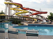 1948 was a start of a great period of change for the city. 2500 acres (10.1 km²) on the Platte Canyon were purchased, and soon McLellan Reservoir was created. This ensured water independence from the powerful Denver Water, and in fact, Englewood provides water to most of the south metro area now due to its vast, early-established water rights. Soon after the city embarked on a huge building boom; most of the city was in fact built up by 1960.
 In 1965 City Park was sold to make way for Cinderella City, the largest mall west of the Mississippi River
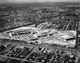
and one of the largest in the world when it opened in 1968. The developer provided the funds to create a vast city park network to replace the single City Park that the mall was built on. Thirty years later, the city demolished the defunct mall in order to make way for a new, transit-orientated development that would also contain a new Civic Center, library, and the relocated city hall. The RTD completed its southeast light rail corridor in 2000, and established passenger rail transit in Englewood.
In 2006 Englewood opened the Pirates Cove water park as part of a multi-million-dollar improvement package for the city parks system. In addition to Pirates Cove many improvements were made to the South Platte River trail system and to the Englewood Recreation Center, originally constructed in 1975.
Englewood is a full-service city with its own, independent park, library, and public works systems. Englewood provides snowplow service to neighboring municipalities and water to a large portion of the metro area.
According to the United States Census Bureau
, the city has a total area of 6.6 square miles (17.1 km²), of which, 6.6 square miles (17.1 km²) of it is land and 0.1 square mile (0.258998811 km²) of it (0.76%) is water.
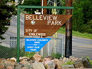 The southwest side also features Englewood's largest park, Belleview Park, and a small reservoir. The southeast section is almost purely residential and is newer than the north and southwest sides. Finally, northeast Englewood is home to one of the largest hospital complexes in the metro area. Swedish Medical Center
and Craig Hospital
, a top-ten nationally ranked rehabilitation hospital for spinal cord and traumatic brain injury rehabilitation, comprise the hospital district, the backbone of the city economy. The Hampden Hills neighborhood hosts one of the largest conglomeration of apartment complexes in the metro area, and is also the newest developed part of the city as well as the wealthiest.
Englewood also features some large annexed areas, such as the northwest annex that extends to Evans Avenue in Denver, which is chiefly manufacturing and industry. Finally, Englewood extends southeast to the Highline Canal, and southwest past Federal Blvd. approaching the Town of Bow Mar.
of 2000, there were 31,727 people, 14,392 households, and 7,469 families residing in the city. The population density
was 4,843.8 people per square mile (1,870.2/km²). There were 14,916 housing units at an average density of 2,276.4 per square mile (879.3/km²). The racial makeup of the city was 77.8% White, 11.5% African American, 1.3% Native American, 1.9% Asian, 0.1% Pacific Islander, and 2.5% from two or more races. Hispanic or Latino of any race were 13% of the population.
There were 14,392 households out of which 23.6% had children under the age of 18 living with them, 36.7% were married couples
living together, 10.8% had a female householder with no husband present, and 48.1% were non-families. 37.9% of all households were made up of individuals and 9.5% had someone living alone who was 65 years of age or older. The average household size was 2.15 and the average family size was 2.88.
In the city the population distribution was varied, with 20.3% under the age of 18, 9.6% from 18 to 24, 35.9% from 25 to 44, 20.0% from 45 to 64, and 14.2% who were 65 years of age or older. The median age was 36 years. For every 100 females there were 98.1 males. For every 100 females age 18 and over, there were 96.4 males.
The median income for a household in the city was $38,943, and the median income for a family was $47,290. Males had a median income of $32,636 versus $28,480 for females. The per capita income
for the city was $20,904. About 4.9% of families and 8.2% of the population were below the poverty line, including 9.0% of those under age 18 and 7.5% of those age 65 or over.
is named after Englewood, but is not in proximity to Englewood. It is in unincorporated
Jefferson County
.
. Small parts of the city are served by the Littleton Public Schools
and the Sheridan Public Schools. Some of neighboring Cherry Hills Village is within the Englewood School district.
The city is also home to a number of private schools, including the Saint Louis School, a large Catholic K-12 institution. Also, the city used to host the Denver Seminary
, an evangelical graduate-level religious school that has since relocated to Littleton. The former seminary site is now slated for redevelopment.
, Cherry Hills Village
, Greenwood Village
, or Centennial
; or in Meridian
in unincorporated Douglas County
. This area includes part of the Denver Tech Center
and the surrounding commercial development along the I-25
corridor, which is often erroneously attributed to Englewood; the city actually lies several miles west.
Arapahoe County, Colorado
As of the census of 2000, there were 487,967 people, 190,909 households, and 125,809 families residing in the county. The population density was 608 people per square mile . There were 196,835 housing units at an average density of 245 per square mile...
, Colorado
Colorado
Colorado is a U.S. state that encompasses much of the Rocky Mountains as well as the northeastern portion of the Colorado Plateau and the western edge of the Great Plains...
, United States
United States
The United States of America is a federal constitutional republic comprising fifty states and a federal district...
. As of 2007, the city is estimated to have a total population of 32,532. Englewood is part of the Denver-Aurora Metropolitan Area
Denver-Aurora Metropolitan Area
The Denver-Aurora-Broomfield, CO Metropolitan Statistical Area is a United States Census Bureau defined Metropolitan Statistical Area in the State of Colorado that includes the City and County of Denver and nine suburban counties. The Census Bureau estimates that the population was 2,357,404 on...
. Englewood is located in the South Platte River Valley east of the Front Range
Front Range
The Front Range is a mountain range of the Southern Rocky Mountains of North America located in the north-central portion of the U.S. State of Colorado and southeastern portion of the U.S. State of Wyoming. It is the first mountain range encountered moving west along the 40th parallel north across...
and immediately south of central Denver. Downtown is located immediately east of the confluence of Little Dry Creek and the South Platte River
South Platte River
The South Platte River is one of the two principal tributaries of the Platte River and itself a major river of the American Midwest and the American Southwest/Mountain West, located in the U.S. states of Colorado and Nebraska...
, between Santa Fe Drive and Broadway.
Englewood is the 4th most populous city in Arapahoe County and, in 2000, was the 20th most populous city in Colorado.
History
The history of Englewood begins when gold was discovered on what came to be called Little Dry Creek by William Green Russell, an early settler of the high plains, in 1858. Two years later, Thomas Skerritt, considered to be the founder of the city, established a home in the area, which was called Orchard Place. Four years later the first road connecting Denver and Orchard Place was created by Skerritt himself using his own plough. In 1879 the first telephone arrived in the area.1883 was an important year, as it was the year that the Cherrelyn horsecar path was laid. The Cherrelyn trolley was and is an important city icon, being carried up Broadway by horse and down by gravity. 1903 brought incorporation, but Skerritt was edged out by J.C. Jones as the first city mayor. Jones was a prominent landowner, having originally owned almost all of what is now north Englewood. The next two years brought the establishment of the first newspaper in the city, soon to be named the Herald. In 1905 Swedish National Sanitorium was founded, soon to become the massive present-day Swedish Medical Center. 1906 brought the first pavement and street lights, and a year later the police and fire departments were established. In 1908 the famed Cherrelyn horse trolley stopped running.
Mississippi River
The Mississippi River is the largest river system in North America. Flowing entirely in the United States, this river rises in western Minnesota and meanders slowly southwards for to the Mississippi River Delta at the Gulf of Mexico. With its many tributaries, the Mississippi's watershed drains...
and one of the largest in the world when it opened in 1968. The developer provided the funds to create a vast city park network to replace the single City Park that the mall was built on. Thirty years later, the city demolished the defunct mall in order to make way for a new, transit-orientated development that would also contain a new Civic Center, library, and the relocated city hall. The RTD completed its southeast light rail corridor in 2000, and established passenger rail transit in Englewood.
In 2006 Englewood opened the Pirates Cove water park as part of a multi-million-dollar improvement package for the city parks system. In addition to Pirates Cove many improvements were made to the South Platte River trail system and to the Englewood Recreation Center, originally constructed in 1975.
Englewood is a full-service city with its own, independent park, library, and public works systems. Englewood provides snowplow service to neighboring municipalities and water to a large portion of the metro area.
Geography
Englewood is located at 39°38′49"N 104°59′31"W (39.646837, -104.991986). The city is 5371 feet (1,637.1 m) above sea level, higher than Denver.According to the United States Census Bureau
United States Census Bureau
The United States Census Bureau is the government agency that is responsible for the United States Census. It also gathers other national demographic and economic data...
, the city has a total area of 6.6 square miles (17.1 km²), of which, 6.6 square miles (17.1 km²) of it is land and 0.1 square mile (0.258998811 km²) of it (0.76%) is water.
Climate
Englewood features a climate very similar to that of Denver's, but is slightly more mild and stable due to the city's establishment in a very low part of the South Platte River valley. Winds are very sparse throughout the city.Neighborhoods
Central Englewood can be roughly divided into quadrants, with the x-axis being Hampden Avenue and the y-axis being Broadway. The northwest is the oldest section of the city, containing the new CityCenter, downtown, and housing stock dating to the 1910s. This is also where the massive General Iron metal fabrication plant was located, which closed in the 1990s and has now been demolished, awaiting redevelopment and a new proposed light rail station at Bates Avenue. The southwest section is home to a newer housing stock as well as a significant percentage of Englewood's industrial and production facilities.Swedish Medical Center (Colorado)
Swedish Medical Center is a 368 bed acute care hospital located in Englewood, Colorado, United States.It is operated by HealthONE Colorado, a joint venture between Hospital Corporation of America and The Colorado Health Foundation....
and Craig Hospital
Craig Hospital
Craig Hospital is a Rehabilitation Hospital in Englewood, Colorado specializing in Spinal cord injury and Traumatic Brain Injury . It has consistently been ranked in the Top Ten Rehabilitation Hospitals in the U.S. by U.S...
, a top-ten nationally ranked rehabilitation hospital for spinal cord and traumatic brain injury rehabilitation, comprise the hospital district, the backbone of the city economy. The Hampden Hills neighborhood hosts one of the largest conglomeration of apartment complexes in the metro area, and is also the newest developed part of the city as well as the wealthiest.
Englewood also features some large annexed areas, such as the northwest annex that extends to Evans Avenue in Denver, which is chiefly manufacturing and industry. Finally, Englewood extends southeast to the Highline Canal, and southwest past Federal Blvd. approaching the Town of Bow Mar.
Demographics
As of the censusCensus
A census is the procedure of systematically acquiring and recording information about the members of a given population. It is a regularly occurring and official count of a particular population. The term is used mostly in connection with national population and housing censuses; other common...
of 2000, there were 31,727 people, 14,392 households, and 7,469 families residing in the city. The population density
Population density
Population density is a measurement of population per unit area or unit volume. It is frequently applied to living organisms, and particularly to humans...
was 4,843.8 people per square mile (1,870.2/km²). There were 14,916 housing units at an average density of 2,276.4 per square mile (879.3/km²). The racial makeup of the city was 77.8% White, 11.5% African American, 1.3% Native American, 1.9% Asian, 0.1% Pacific Islander, and 2.5% from two or more races. Hispanic or Latino of any race were 13% of the population.
There were 14,392 households out of which 23.6% had children under the age of 18 living with them, 36.7% were married couples
Marriage
Marriage is a social union or legal contract between people that creates kinship. It is an institution in which interpersonal relationships, usually intimate and sexual, are acknowledged in a variety of ways, depending on the culture or subculture in which it is found...
living together, 10.8% had a female householder with no husband present, and 48.1% were non-families. 37.9% of all households were made up of individuals and 9.5% had someone living alone who was 65 years of age or older. The average household size was 2.15 and the average family size was 2.88.
In the city the population distribution was varied, with 20.3% under the age of 18, 9.6% from 18 to 24, 35.9% from 25 to 44, 20.0% from 45 to 64, and 14.2% who were 65 years of age or older. The median age was 36 years. For every 100 females there were 98.1 males. For every 100 females age 18 and over, there were 96.4 males.
The median income for a household in the city was $38,943, and the median income for a family was $47,290. Males had a median income of $32,636 versus $28,480 for females. The per capita income
Per capita income
Per capita income or income per person is a measure of mean income within an economic aggregate, such as a country or city. It is calculated by taking a measure of all sources of income in the aggregate and dividing it by the total population...
for the city was $20,904. About 4.9% of families and 8.2% of the population were below the poverty line, including 9.0% of those under age 18 and 7.5% of those age 65 or over.
Government and infrastructure
The Federal Correctional Institution, EnglewoodFederal Correctional Institution, Englewood
The Federal Correctional Institution Englewood is a Federal Bureau of Prisons low security facility for male offenders, located in unincorporated Jefferson County. FCI Englewood is located off of U.S. Route 285 and Kipling Street, southwest of Denver...
is named after Englewood, but is not in proximity to Englewood. It is in unincorporated
Unincorporated area
In law, an unincorporated area is a region of land that is not a part of any municipality.To "incorporate" in this context means to form a municipal corporation, a city, town, or village with its own government. An unincorporated community is usually not subject to or taxed by a municipal government...
Jefferson County
Jefferson County, Colorado
Jefferson County , whose slogan is the "Gateway to the Rocky Mountains", is the fourth most populous of the 64 counties of the State of Colorado of the United States. Located along the Front Range of the Rocky Mountains, Jefferson County is adjacent to the west side of the state capital, Denver....
.
Education
The City of Englewood is served by the Englewood Public Schools (EPS), a shrinking district of 3300 students as of 2007 with two high schools, Englewood High and Colorado's Finest Alternative High SchoolColorado's Finest Alternative High School
Colorado's Finest Alternative High School is an alternative public high school in Englewood, Colorado, a suburb of Denver.CFAHS serves students who prefer to attend an alternative program with a flexible start and end time...
. Small parts of the city are served by the Littleton Public Schools
Littleton Public Schools
Littleton Public Schools is a school district in Littleton, Colorado which serves several communities south of central Denver in the Denver metropolitan area.Scott Murphy is the superintendent...
and the Sheridan Public Schools. Some of neighboring Cherry Hills Village is within the Englewood School district.
The city is also home to a number of private schools, including the Saint Louis School, a large Catholic K-12 institution. Also, the city used to host the Denver Seminary
Denver Seminary
Denver Seminary is an accredited, graduate-level institution in Littleton, Colorado. It offers a wide range of degrees not typically associated with other accredited seminaries. It is also known for its emphasis on training and mentoring as integral to seminary education...
, an evangelical graduate-level religious school that has since relocated to Littleton. The former seminary site is now slated for redevelopment.
Top employers
According to the City's 2009 Comprehensive Annual Financial Report, the top employers in the city are:| # | Employer | # of Employees |
|---|---|---|
| 1 | Swedish Medical Center Swedish Medical Center (Colorado) Swedish Medical Center is a 368 bed acute care hospital located in Englewood, Colorado, United States.It is operated by HealthONE Colorado, a joint venture between Hospital Corporation of America and The Colorado Health Foundation.... |
2,000 |
| 2 | Craig Hospital Craig Hospital Craig Hospital is a Rehabilitation Hospital in Englewood, Colorado specializing in Spinal cord injury and Traumatic Brain Injury . It has consistently been ranked in the Top Ten Rehabilitation Hospitals in the U.S. by U.S... |
750 |
| 3 | Sports Authority Sports Authority The Sports Authority, Inc. is one of the largest sporting goods retailers in the United States. It is headquartered in Englewood, Colorado, and operates more than 460 stores in 45 U.S... |
600 |
| 4 | Englewood School District | 525 |
| 5 | City of Englewood | 520 |
| 6 | Burt Chevrolet Chevrolet Chevrolet , also known as Chevy , is a brand of vehicle produced by General Motors Company . Founded by Louis Chevrolet and ousted GM founder William C. Durant on November 3, 1911, General Motors acquired Chevrolet in 1918... on Broadway |
400 |
| 7 | Windsor Kärcher Alfred Kärcher GmbH & Co. KG is a German manufacturer of cleaning systems and equipment, known for its high-pressure cleaners.- History :The inventor Alfred Kärcher from Baden-Württemberg founded the company in 1935. Initially Kärcher specialised in the design of industrial submersible heating... |
350 |
| 8 | Dr Pepper Snapple Group Dr Pepper Snapple Group Dr Pepper Snapple Group Inc. is an American soft drink company, based in Plano, Texas.It was spun off from Britain's Cadbury Schweppes, on May 5, 2008, with trading in its shares starting on May 7, 2008... |
300 |
| 9 | Meadow Gold Dairies | 230 |
| 10 | Wal-Mart Wal-Mart Wal-Mart Stores, Inc. , branded as Walmart since 2008 and Wal-Mart before then, is an American public multinational corporation that runs chains of large discount department stores and warehouse stores. The company is the world's 18th largest public corporation, according to the Forbes Global 2000... |
150 |
Adjacent municipalities and unincorporated areas
The place name "Englewood" is assigned to three ZIP codes which cover areas adjacent to the city on the west and east, and an area southeast of the city that is much larger than the city itself. Thus, many addresses written as "Englewood, Colorado" are actually in the Arapahoe County cities of SheridanSheridan, Colorado
Sheridan is a Home Rule Municipality in Arapahoe County, Colorado, United States. The population was 5,600 at the 2000 census.-Geography:Sheridan is located at ....
, Cherry Hills Village
Cherry Hills Village, Colorado
The city of Cherry Hills Village is a Denver suburb and Home Rule Municipality located in Arapahoe County, Colorado, United States. The population was 5,958 at the 2000 census. It is one of the most affluent places in Colorado and the United States....
, Greenwood Village
Greenwood Village, Colorado
The city of Greenwood Village is a prominent suburb of the Denver-Aurora Metropolitan Statistical Area and a Home Rule Municipality located in Arapahoe County, Colorado, United States...
, or Centennial
Centennial, Colorado
The city of Centennial is a Home Rule City located in Arapahoe County, Colorado, United States, and part of the Denver-Aurora metropolitan area. The city was to have a total population of 100,377 in 2010 census. Centennial is the tenth-most populous municipality in the state of Colorado and its...
; or in Meridian
Meridian, Colorado
Meridian is a census-designated place in Douglas County, Colorado, United States. The population was 184 at the 2000 census.-Geography:Meridian is located at ....
in unincorporated Douglas County
Douglas County, Colorado
Douglas County is the eighth most populous of the 64 counties of the state of Colorado, in the United States. The county is located midway between Colorado's two largest cities: Denver and Colorado Springs...
. This area includes part of the Denver Tech Center
Denver Technological Center
Denver Technological Center, better known as The Denver Tech Center or DTC, is a business and economic trading center located in Colorado in the southeastern portion of the Denver Metropolitan Area, within portions of the cities of Denver and Greenwood Village. It is home to several major...
and the surrounding commercial development along the I-25
Interstate 25 in Colorado
In the U.S. state of Colorado, Interstate 25 follows the north–south corridor through Colorado Springs and Denver. It replaced U.S. Highway 87 and most of U.S. Highway 85 for through traffic....
corridor, which is often erroneously attributed to Englewood; the city actually lies several miles west.
| North: Denver Denver, Colorado The City and County of Denver is the capital and the most populous city of the U.S. state of Colorado. Denver is a consolidated city-county, located in the South Platte River Valley on the western edge of the High Plains just east of the Front Range of the Rocky Mountains... |
||
| West: Sheridan Sheridan, Colorado Sheridan is a Home Rule Municipality in Arapahoe County, Colorado, United States. The population was 5,600 at the 2000 census.-Geography:Sheridan is located at .... , Bow Mar Bow Mar, Colorado The town of Bow Mar is a Statutory Town in Arapahoe and Jefferson counties in the U.S. state of Colorado. Bow Mar is part of the Denver Metropolitan Area. The population was 847 at the 2000 census.-History:... , Denver Denver, Colorado The City and County of Denver is the capital and the most populous city of the U.S. state of Colorado. Denver is a consolidated city-county, located in the South Platte River Valley on the western edge of the High Plains just east of the Front Range of the Rocky Mountains... , Littleton Littleton, Colorado Littleton is a Home Rule Municipality contained in Arapahoe, Douglas, and Jefferson counties in the U.S. state of Colorado. Littleton is a suburb of the Denver-Aurora Metropolitan Statistical Area. Littleton is the county seat of Arapahoe County and the 20th most populous city in the state of... |
East: Denver Denver, Colorado The City and County of Denver is the capital and the most populous city of the U.S. state of Colorado. Denver is a consolidated city-county, located in the South Platte River Valley on the western edge of the High Plains just east of the Front Range of the Rocky Mountains... , Cherry Hills Village Cherry Hills Village, Colorado The city of Cherry Hills Village is a Denver suburb and Home Rule Municipality located in Arapahoe County, Colorado, United States. The population was 5,958 at the 2000 census. It is one of the most affluent places in Colorado and the United States.... , Greenwood Village Greenwood Village, Colorado The city of Greenwood Village is a prominent suburb of the Denver-Aurora Metropolitan Statistical Area and a Home Rule Municipality located in Arapahoe County, Colorado, United States... |
|
| South: Littleton Littleton, Colorado Littleton is a Home Rule Municipality contained in Arapahoe, Douglas, and Jefferson counties in the U.S. state of Colorado. Littleton is a suburb of the Denver-Aurora Metropolitan Statistical Area. Littleton is the county seat of Arapahoe County and the 20th most populous city in the state of... , Greenwood Village Greenwood Village, Colorado The city of Greenwood Village is a prominent suburb of the Denver-Aurora Metropolitan Statistical Area and a Home Rule Municipality located in Arapahoe County, Colorado, United States... |
See also
- Colorado municipalitiesColorado municipalitiesThe U.S. state of Colorado currently has 271 active incorporated municipalities, including 196 towns, 73 cities, and two consolidated city and county governments.-Municipal government:...
- Denver-Aurora Metropolitan Statistical Area
- Denver-Aurora-Boulder Combined Statistical AreaDenver-Aurora-Boulder Combined Statistical Areathumb|300px|Map of the 12-county Denver-Aurora-Boulder Combined Statistical AreaThe Denver-Aurora-Boulder, CO Combined Statistical Area is a United States Census Bureau defined Combined Statistical Area located in the Denver region of the state of Colorado...
- Executive RecyclingExecutive RecyclingExecutive Recycling is an Englewood, Colorado-based business specializing in electronic waste recycling. 60 Minutes linked Executive Recycling to the illegal export of electronic waste from the Denver area to Guiyu, China...
- Front Range Urban CorridorFront Range Urban CorridorThe Front Range Urban Corridor is an oblong region of urban population located along the eastern face of the Southern Rocky Mountains in the U.S. states of Colorado and Wyoming. The corridor derives its name from the Front Range, the mountain range that defines the west central boundary of the...