
Littleton, Colorado
Encyclopedia
Littleton is a Home Rule Municipality contained in Arapahoe
, Douglas
, and Jefferson
counties in the U.S. state
of Colorado
. Littleton is a suburb of the Denver-Aurora Metropolitan Statistical Area
. Littleton is the county seat
of Arapahoe County
and the 20th most populous city in the state of Colorado
. The population was 41,737 at the 2010 census.
The city of Littleton's history dates back to the 1859 Pike's Peak Gold Rush, which brought not only gold seekers, but merchants and farmers to the community. Richard Sullivan Little was an engineer from New Hampshire that made his way out west to work on irrigation systems. Little quickly fell in love with the area that is present day Littleton and brought his wife Angeline out from the East in 1862. The Littles, along with many neighbors, built the Rough and Ready Flour Mill in 1867, which provided a solid economic base in the community. By 1890, the community had grown to 245 people and the residents voted to incorporate the Town of Littleton.
The Colorado Center for the Blind, a skills training program for blind teenagers and adults operated by the National Federation of the Blind, is located in Littleton. Denver Seminary is also in Littleton.
Intelligent Vehicle Safety Technologies' "Desert Tortoise," a competitor in the DARPA Grand Challenge
, is based in Littleton.
The city is also the site of the grave of Alferd Packer
, an American prospector
and the only convicted cannibal in the United States.
Littleton is also considered by many to be the location of the Columbine High School Massacre
at Columbine High School
in 1999, though the location of the school is somewhat unclear on account of the unincorporated
nature of Jefferson County
.
According to the United States Census Bureau
, the city has a total area of 13.9 square miles (36.1 km²), of which, 13.5 square miles (35.0 km²) of it is land and 0.4 square miles (1.1 km²) of it (2.95%) is water.
Littleton is a suburb
south of Denver
, on the west side of I-25. Since July 2000, it has been served by the Regional Transportation District
's light rail
system.
of 2000 there were 40,340 people; 17,313 households; and 10,387 families residing in the city. The population density
was 2,984.8 people per square mile (1,152.0/km²). There were 18,084 housing units at an average density of 1,338.0 per square mile (516.4/km²). The racial makeup of the city was 91.77% White, 1.16% African American, 0.73% Native American, 1.66% Asian, 0.06% Pacific Islander, 2.67% from other races
, and 1.95% from two or more races. Hispanic or Latino of any race were 8.45% of the population.
There were 17,313 households out of which 28.0% had children under the age of 18 living with them, 47.3% were married couples
living together, 9.2% had a female householder with no husband present, and 40.0% were non-families. 33.3% of all households were made up of individuals and 11.1% had someone living alone who was 65 years of age or older. The average household size was 2.29 and the average family size was 2.96.
In the city the population was spread out with 23.3% under the age of 18, 8.2% from 18 to 24, 30.1% from 25 to 44, 24.2% from 45 to 64, and 14.2% who were 65 years of age or older. The median age was 39 years. For every 100 females there were 94.5 males. For every 100 females age 18 and over, there were 91.0 males.
The median income for a household in the city was $50,583, and the median income for a family was $64,671. Males had a median income of $43,698 versus $33,377 for females. The per capita income for the city was $28,681. About 3.9% of families and 6.0% of the population were below the poverty line, including 7.5% of those under age 18 and 5.1% of those age 65 or over.
attended Heritage High School
in Littleton, and a few aspects of South Park
are loosely based on the city as a result.
has a Littleton mailing address, but is not in proximity to Littleton. It is in unincorporated
Jefferson County
.
Since the late 1920s, Littleton has celebrated Western Welcome Week - an annual community celebration in the greater Littleton area. Western Welcome Week started in the late 1920s, and has been held every year since. Western Welcome Week includes over 40 events benefiting dozens of local civic and charitable organizations.
Western Welcome Week
Western Welcome week is kicked off by the Carousel of Music In 2011, it included performances by the Colorado Honor Band, the Denver Concert Band. and the Littleton Chorale
Candlelight Walk
The candlelight Walk is a Littleton tradition, featuring a magical evening of holiday festivities, culminating in the illumination of the trees on Main Street and ending with a performance by the Littleton Chorale at the stage at the west end of Main Street
s which cover a vast area west, east and south of the city that is much larger than the city itself. Thus the following unincorporated
communities have "Littleton addresses":
Arapahoe County, Colorado
As of the census of 2000, there were 487,967 people, 190,909 households, and 125,809 families residing in the county. The population density was 608 people per square mile . There were 196,835 housing units at an average density of 245 per square mile...
, Douglas
Douglas County, Colorado
Douglas County is the eighth most populous of the 64 counties of the state of Colorado, in the United States. The county is located midway between Colorado's two largest cities: Denver and Colorado Springs...
, and Jefferson
Jefferson County, Colorado
Jefferson County , whose slogan is the "Gateway to the Rocky Mountains", is the fourth most populous of the 64 counties of the State of Colorado of the United States. Located along the Front Range of the Rocky Mountains, Jefferson County is adjacent to the west side of the state capital, Denver....
counties in the U.S. state
U.S. state
A U.S. state is any one of the 50 federated states of the United States of America that share sovereignty with the federal government. Because of this shared sovereignty, an American is a citizen both of the federal entity and of his or her state of domicile. Four states use the official title of...
of Colorado
Colorado
Colorado is a U.S. state that encompasses much of the Rocky Mountains as well as the northeastern portion of the Colorado Plateau and the western edge of the Great Plains...
. Littleton is a suburb of the Denver-Aurora Metropolitan Statistical Area
Denver-Aurora Metropolitan Area
The Denver-Aurora-Broomfield, CO Metropolitan Statistical Area is a United States Census Bureau defined Metropolitan Statistical Area in the State of Colorado that includes the City and County of Denver and nine suburban counties. The Census Bureau estimates that the population was 2,357,404 on...
. Littleton is the county seat
County seat
A county seat is an administrative center, or seat of government, for a county or civil parish. The term is primarily used in the United States....
of Arapahoe County
Arapahoe County, Colorado
As of the census of 2000, there were 487,967 people, 190,909 households, and 125,809 families residing in the county. The population density was 608 people per square mile . There were 196,835 housing units at an average density of 245 per square mile...
and the 20th most populous city in the state of Colorado
Colorado
Colorado is a U.S. state that encompasses much of the Rocky Mountains as well as the northeastern portion of the Colorado Plateau and the western edge of the Great Plains...
. The population was 41,737 at the 2010 census.
The city of Littleton's history dates back to the 1859 Pike's Peak Gold Rush, which brought not only gold seekers, but merchants and farmers to the community. Richard Sullivan Little was an engineer from New Hampshire that made his way out west to work on irrigation systems. Little quickly fell in love with the area that is present day Littleton and brought his wife Angeline out from the East in 1862. The Littles, along with many neighbors, built the Rough and Ready Flour Mill in 1867, which provided a solid economic base in the community. By 1890, the community had grown to 245 people and the residents voted to incorporate the Town of Littleton.
The Colorado Center for the Blind, a skills training program for blind teenagers and adults operated by the National Federation of the Blind, is located in Littleton. Denver Seminary is also in Littleton.
Intelligent Vehicle Safety Technologies' "Desert Tortoise," a competitor in the DARPA Grand Challenge
DARPA Grand Challenge
The DARPA Grand Challenge is a prize competition for driverless vehicles, funded by the Defense Advanced Research Projects Agency, the most prominent research organization of the United States Department of Defense...
, is based in Littleton.
The city is also the site of the grave of Alferd Packer
Alferd Packer
Alfred G. "Alferd" Packer was an American prospector who was accused of cannibalism during the winter of 1873-1874. First tried for murder, Packer was eventually sentenced to 40 years in prison after being convicted of manslaughter...
, an American prospector
Prospecting
Prospecting is the physical search for minerals, fossils, precious metals or mineral specimens, and is also known as fossicking.Prospecting is a small-scale form of mineral exploration which is an organised, large scale effort undertaken by mineral resource companies to find commercially viable ore...
and the only convicted cannibal in the United States.
Littleton is also considered by many to be the location of the Columbine High School Massacre
Columbine High School massacre
The Columbine High School massacre occurred on Tuesday, April 20, 1999, at Columbine High School in Columbine, an unincorporated area of Jefferson County, Colorado, United States, near Denver and Littleton. Two senior students, Eric Harris and Dylan Klebold, embarked on a massacre, killing 12...
at Columbine High School
Columbine High School
Columbine High School or CHS is a high school in unincorporated Jefferson County, Colorado, United States.- History :Columbine High School opened in the fall of 1973. There was no senior class in its first year. The school's first graduating class was the class of 1975...
in 1999, though the location of the school is somewhat unclear on account of the unincorporated
Unincorporated
Unincorporated may refer to:* Unincorporated area, land not governed by a local municipality* Unincorporated entity, a type of organization* Unincorporated territories of the United States, territories under U.S. jurisdiction, to which Congress has determined that only select parts of the U.S...
nature of Jefferson County
Jefferson County
Jefferson County is the name of 25 counties and one parish in the United States:*Jefferson County, Alabama*Jefferson County, Arkansas*Jefferson County, Colorado*Jefferson County, Florida*Jefferson County, Georgia*Jefferson County, Idaho...
.
Geography
Littleton is located at 39°35′59"N 105°0′39"W (39.599691, -105.010929).According to the United States Census Bureau
United States Census Bureau
The United States Census Bureau is the government agency that is responsible for the United States Census. It also gathers other national demographic and economic data...
, the city has a total area of 13.9 square miles (36.1 km²), of which, 13.5 square miles (35.0 km²) of it is land and 0.4 square miles (1.1 km²) of it (2.95%) is water.
Littleton is a suburb
Suburb
The word suburb mostly refers to a residential area, either existing as part of a city or as a separate residential community within commuting distance of a city . Some suburbs have a degree of administrative autonomy, and most have lower population density than inner city neighborhoods...
south of Denver
Denver, Colorado
The City and County of Denver is the capital and the most populous city of the U.S. state of Colorado. Denver is a consolidated city-county, located in the South Platte River Valley on the western edge of the High Plains just east of the Front Range of the Rocky Mountains...
, on the west side of I-25. Since July 2000, it has been served by the Regional Transportation District
Regional Transportation District
The Regional Transportation District, or RTD, was organized in 1969 and is the regional authority operating public transit services in eight of the twelve counties in the Denver-Aurora-Boulder Combined Statistical Area in Colorado. RTD is governed by a 15-member, publicly elected Board of...
's light rail
Light rail
Light rail or light rail transit is a form of urban rail public transportation that generally has a lower capacity and lower speed than heavy rail and metro systems, but higher capacity and higher speed than traditional street-running tram systems...
system.
Demographics
As of the censusCensus
A census is the procedure of systematically acquiring and recording information about the members of a given population. It is a regularly occurring and official count of a particular population. The term is used mostly in connection with national population and housing censuses; other common...
of 2000 there were 40,340 people; 17,313 households; and 10,387 families residing in the city. The population density
Population density
Population density is a measurement of population per unit area or unit volume. It is frequently applied to living organisms, and particularly to humans...
was 2,984.8 people per square mile (1,152.0/km²). There were 18,084 housing units at an average density of 1,338.0 per square mile (516.4/km²). The racial makeup of the city was 91.77% White, 1.16% African American, 0.73% Native American, 1.66% Asian, 0.06% Pacific Islander, 2.67% from other races
Race (United States Census)
Race and ethnicity in the United States Census, as defined by the Federal Office of Management and Budget and the United States Census Bureau, are self-identification data items in which residents choose the race or races with which they most closely identify, and indicate whether or not they are...
, and 1.95% from two or more races. Hispanic or Latino of any race were 8.45% of the population.
There were 17,313 households out of which 28.0% had children under the age of 18 living with them, 47.3% were married couples
Marriage
Marriage is a social union or legal contract between people that creates kinship. It is an institution in which interpersonal relationships, usually intimate and sexual, are acknowledged in a variety of ways, depending on the culture or subculture in which it is found...
living together, 9.2% had a female householder with no husband present, and 40.0% were non-families. 33.3% of all households were made up of individuals and 11.1% had someone living alone who was 65 years of age or older. The average household size was 2.29 and the average family size was 2.96.
In the city the population was spread out with 23.3% under the age of 18, 8.2% from 18 to 24, 30.1% from 25 to 44, 24.2% from 45 to 64, and 14.2% who were 65 years of age or older. The median age was 39 years. For every 100 females there were 94.5 males. For every 100 females age 18 and over, there were 91.0 males.
The median income for a household in the city was $50,583, and the median income for a family was $64,671. Males had a median income of $43,698 versus $33,377 for females. The per capita income for the city was $28,681. About 3.9% of families and 6.0% of the population were below the poverty line, including 7.5% of those under age 18 and 5.1% of those age 65 or over.
In popular culture
Matt StoneMatt Stone
Matthew Richard "Matt" Stone is an American screenwriter, producer, voice artist, musician and actor, best known for being the co-creator of South Park along with creative partner and best friend, Trey Parker....
attended Heritage High School
Heritage High School (Littleton, Colorado)
Heritage High School, in Littleton, Colorado was completed in 1972 as the last of three high schools in the Littleton Public Schools system. It was rated by Newsweek magazine as one of the top 200 high schools in the United States, and the Denver-based 5280 magazine acknowledged Heritage High...
in Littleton, and a few aspects of South Park
South Park
South Park is an American animated television series created by Trey Parker and Matt Stone for the Comedy Central television network. Intended for mature audiences, the show has become famous for its crude language, surreal, satirical, and dark humor that lampoons a wide range of topics...
are loosely based on the city as a result.
Education
- Jeffco Public Schools
- Littleton Public SchoolsLittleton Public SchoolsLittleton Public Schools is a school district in Littleton, Colorado which serves several communities south of central Denver in the Denver metropolitan area.Scott Murphy is the superintendent...
- Arapahoe Community CollegeArapahoe Community CollegeFounded in 1965, Arapahoe Community College was the first community college to open in the Denver area. What began as Arapahoe Junior College with 550 students, has grown into a vibrant community college serving over 18,000 credit and non-credit students yearly.The College now offers over 100...
- Denver SeminaryDenver SeminaryDenver Seminary is an accredited, graduate-level institution in Littleton, Colorado. It offers a wide range of degrees not typically associated with other accredited seminaries. It is also known for its emphasis on training and mentoring as integral to seminary education...
Points of interest
- Hudson GardensHudson GardensThe Hudson Gardens 30 acres are non-profit botanical gardens located along the bank of the South Platte River, at 6115 South Santa Fe Drive in Littleton, Colorado, USA. They are open 365 days a year, with no admission fee from November through April.The Gardens began in 1941 as the private garden...
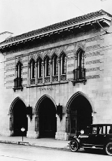
- Town Hall Arts CenterTown Hall Arts CenterTown Hall Arts Center is located in downtown Littleton, Colorado and has been a local professional theatre favorite, producing fine comedies, musicals and plays to the Denver Metro area for over 20 years.-Starting out:...
, providing professional theater to the surrounding metro area. - The Littleton Museum
- The Gravesite of Alferd Packer Alferd PackerAlferd PackerAlfred G. "Alferd" Packer was an American prospector who was accused of cannibalism during the winter of 1873-1874. First tried for murder, Packer was eventually sentenced to 40 years in prison after being convicted of manslaughter...
Government and infrastructure
The Federal Correctional Institution, EnglewoodFederal Correctional Institution, Englewood
The Federal Correctional Institution Englewood is a Federal Bureau of Prisons low security facility for male offenders, located in unincorporated Jefferson County. FCI Englewood is located off of U.S. Route 285 and Kipling Street, southwest of Denver...
has a Littleton mailing address, but is not in proximity to Littleton. It is in unincorporated
Unincorporated area
In law, an unincorporated area is a region of land that is not a part of any municipality.To "incorporate" in this context means to form a municipal corporation, a city, town, or village with its own government. An unincorporated community is usually not subject to or taxed by a municipal government...
Jefferson County
Jefferson County, Colorado
Jefferson County , whose slogan is the "Gateway to the Rocky Mountains", is the fourth most populous of the 64 counties of the State of Colorado of the United States. Located along the Front Range of the Rocky Mountains, Jefferson County is adjacent to the west side of the state capital, Denver....
.
Community events
Western Welcome WeekSince the late 1920s, Littleton has celebrated Western Welcome Week - an annual community celebration in the greater Littleton area. Western Welcome Week started in the late 1920s, and has been held every year since. Western Welcome Week includes over 40 events benefiting dozens of local civic and charitable organizations.
Western Welcome Week
Western Welcome week is kicked off by the Carousel of Music In 2011, it included performances by the Colorado Honor Band, the Denver Concert Band. and the Littleton Chorale
Candlelight Walk
The candlelight Walk is a Littleton tradition, featuring a magical evening of holiday festivities, culminating in the illumination of the trees on Main Street and ending with a performance by the Littleton Chorale at the stage at the west end of Main Street
Community Organizations
Neighboring communities with Littleton ZIP codes
The place name "Littleton" is assigned to eleven ZIP codeZIP Code
ZIP codes are a system of postal codes used by the United States Postal Service since 1963. The term ZIP, an acronym for Zone Improvement Plan, is properly written in capital letters and was chosen to suggest that the mail travels more efficiently, and therefore more quickly, when senders use the...
s which cover a vast area west, east and south of the city that is much larger than the city itself. Thus the following unincorporated
Unincorporated area
In law, an unincorporated area is a region of land that is not a part of any municipality.To "incorporate" in this context means to form a municipal corporation, a city, town, or village with its own government. An unincorporated community is usually not subject to or taxed by a municipal government...
communities have "Littleton addresses":
- Acres Green, ColoradoAcres Green, ColoradoAs of the census of 2000, there were 3,205 people, 1,046 households, and 875 families residing in the CDP. The population density was 5,168.2 people per square mile . There were 1,052 housing units at an average density of 1,696.4 per square mile...
- Carriage Club, ColoradoCarriage Club, ColoradoCarriage Club is a former census-designated place in Douglas County, Colorado, United States. The population was 1,002 at the 2000 census. The area has been annexed by the city of Lone Tree.-Geography:...
- Columbine, ColoradoColumbine, ColoradoColumbine is a census-designated place in Arapahoe and Jefferson Counties in the U.S. state of Colorado. Located mostly in Jefferson County, it lies immediately west of Littleton....
- Heritage Hills, ColoradoHeritage Hills, ColoradoHeritage Hills is a former census-designated place in Douglas County, Colorado, United States. The population was 658 at the 2000 census. The area has been annexed by the city of Lone Tree.-Geography:...
- Highlands Ranch, ColoradoHighlands Ranch, ColoradoHighlands Ranch is a census-designated place in Douglas County, Colorado, United States. The population was 96,713 at the 2010 census; it is one of the most populous unincorporated communities in the United States...
- Ken Caryl, ColoradoKen Caryl, ColoradoLockheed Martin and its predecessor, Martin Marietta, operate a facility located in Ken Caryl Valley.-In popular culture:In the South Park episode Trapped in the Closet, a reference is made to FunPlex, an amusement center in Ken Caryl, though it has since been renamed Fun City.-External links:*...
- Roxborough Park, ColoradoRoxborough Park, ColoradoRoxborough Park is a census-designated place in Douglas County, Colorado, United States. The population was 4,446 at the 2000 census.-Geography:Roxborough Park is located at ....
See also
- Littleton GazetteLittleton GazetteThe Littleton Gazette is an online newspaper based in Littleton, Colorado. It specializes in local, community-based news and invites contributions from its readers and local businesses...
- Colorado municipalitiesColorado municipalitiesThe U.S. state of Colorado currently has 271 active incorporated municipalities, including 196 towns, 73 cities, and two consolidated city and county governments.-Municipal government:...
- Denver-Aurora Metropolitan Statistical Area
- Denver-Aurora-Boulder Combined Statistical AreaDenver-Aurora-Boulder Combined Statistical Areathumb|300px|Map of the 12-county Denver-Aurora-Boulder Combined Statistical AreaThe Denver-Aurora-Boulder, CO Combined Statistical Area is a United States Census Bureau defined Combined Statistical Area located in the Denver region of the state of Colorado...
- Front Range Urban CorridorFront Range Urban CorridorThe Front Range Urban Corridor is an oblong region of urban population located along the eastern face of the Southern Rocky Mountains in the U.S. states of Colorado and Wyoming. The corridor derives its name from the Front Range, the mountain range that defines the west central boundary of the...
- Danny DietzDanny DietzGunner's Mate 2nd Class Danny Phillip Dietz Jr. of Littleton, Colorado was a U.S. Navy SEAL who was posthumously awarded the United States' 2nd highest citation for valor, the Navy Cross, on 13 September 2006.-Biography:...
, holder of the Navy Cross, born here - James M. HydeJames M. HydeJames M. Hyde was a metallurgist who was noted for inventing a process that revolutionized the American mining industry. He was also a member of the Los Angeles, California, City Council from 1931 to 1939.-Biography:...
, metallurgist, former resident