
Elmenteita Badlands
Encyclopedia
The Elementeita Badlands, also known as the Otutu Forest or Ututu Forest, is a lava flow in Kenya
that covers approximately 9000 acres (36.4 km²). The area was previously covered in thick dryland forest characterized by cedar trees, (Juniperus spp.), and Leleshwa bushes (Tarchonanthus camphoratus
). In addition, Wild Jasmine
and Boophone
are also found.
The land belongs to Njenga Karume
, who bought it from Arthur Cole in 1980. Cole had bought it from Digby Tatham-Warter (famous for his role in the Battle of Arnhem) in 1968, as grazing land of low potential. The land is unsuitable for either small scale cultivation or cattle ranching as it is covered in thick bush growing from the profusion of lava boulders.
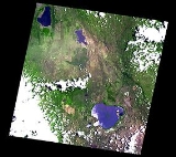
age. The highest peak has an elevation of 2126 metres. It is located between Lake Elmenteita
and Ol Doinyo Eburru volcano, on the southern boundary of the Soysambu Conservancy
. Some of the prominent peaks include "Horseshoe Crater" and "Scout Hat Hill". There are some lava tube caves
which show evidence of prehistoric occupation as grinding plates and stone bowls have been recovered by the local people in rudimentary excavation. These caves have been occupied by some of the refugees from the 2008 post-election violence in Kenya.
, poaching
and changaa
brewing. A trading centre has been built at the northeastern corner known as "Soko Mjinga" (Fool's Market) which is the place to trade in these items.
The living conditions in the Otutu forest have led to an outbreak of leishmaniasis
or Aleppo boil which is spread by sandflies and rock hyrax, which are numerous there. The only sources of water are from some small steam vents beside the old railway line along the eastern boundary of the forest (currently a road), which ran between Elmenteita
and Gilgil
before it was realigned in 1945. The Eburru station (now defunct) is on the edge of the Otutu and is notable for the steam condensers made from oil drums and corrugated iron sheets which the residents construct for their water source.
A luxury tourist lodge, called Mawe Mbili
Lodge, is currently under construction on the western boundary of the forest, on the slopes of "Scout Hat Hill", so called because the shape resembles Baden Powell's hat. It is projected to open in March 2009. The water supply is from rainwater caught from plastic sheeting and from a deep and alkaline borehole
which provides water at over 50 degrees Celsius and a pH of nearly 8.
Kenya
Kenya , officially known as the Republic of Kenya, is a country in East Africa that lies on the equator, with the Indian Ocean to its south-east...
that covers approximately 9000 acres (36.4 km²). The area was previously covered in thick dryland forest characterized by cedar trees, (Juniperus spp.), and Leleshwa bushes (Tarchonanthus camphoratus
Tarchonanthus camphoratus
Tarchonanthus camphoratus , is a shrub or small tree, native to eastern and Southern Africa and Arabia....
). In addition, Wild Jasmine
Jasmine
Jasminum , commonly known as jasmines, is a genus of shrubs and vines in the olive family . It contains around 200 species native to tropical and warm temperate regions of the Old World...
and Boophone
Boophone
Boophone is a genus of herbaceous, perennial and bulbous plants in the Amaryllis family . It consists of two species distributed in Tropical and Southern Africa...
are also found.
The land belongs to Njenga Karume
Njenga Karume
- Business :Karume holds diploma in business management from Jeans School . While Kenya was still under colonial rule, he formed a wholesale shop on Grogan Road in Nairobi. It was one of the few shops in Kenya operated by indigenous people.Later he operated the Nararashi Distributors, who...
, who bought it from Arthur Cole in 1980. Cole had bought it from Digby Tatham-Warter (famous for his role in the Battle of Arnhem) in 1968, as grazing land of low potential. The land is unsuitable for either small scale cultivation or cattle ranching as it is covered in thick bush growing from the profusion of lava boulders.
Geography
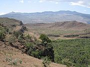
The land is punctuated by pyroclastic cones of HoloceneHolocene
The Holocene is a geological epoch which began at the end of the Pleistocene and continues to the present. The Holocene is part of the Quaternary period. Its name comes from the Greek words and , meaning "entirely recent"...
age. The highest peak has an elevation of 2126 metres. It is located between Lake Elmenteita
Lake Elmenteita
Lake Elmenteita, also spelled Elementaita, is a soda lake, in the eastern limb of East Africa's Great Rift Valley, about 120 km northwest of Nairobi, Kenya.- Geography :...
and Ol Doinyo Eburru volcano, on the southern boundary of the Soysambu Conservancy
Soysambu conservancy
The Soysambu Conservancy was created in 2008 as an entity to conserve the flora, fauna and scenery of Soysambu Ranch, which is to the northwest of Gilgil, Rift Valley Province, Kenya....
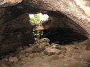
. Some of the prominent peaks include "Horseshoe Crater" and "Scout Hat Hill". There are some lava tube caves
Lava tube
Lava tubes are natural conduits through which lava travels beneath the surface of a lava flow, expelled by a volcano during an eruption. They can be actively draining lava from a source, or can be extinct, meaning the lava flow has ceased and the rock has cooled and left a long, cave-like...
which show evidence of prehistoric occupation as grinding plates and stone bowls have been recovered by the local people in rudimentary excavation. These caves have been occupied by some of the refugees from the 2008 post-election violence in Kenya.
People in the Elmenteita Badlands
The area was heavily degraded from the 1980s onwards, being a hideout for disaffected and dienfranchised people who have resorted to charcoal burningCharcoal
Charcoal is the dark grey residue consisting of carbon, and any remaining ash, obtained by removing water and other volatile constituents from animal and vegetation substances. Charcoal is usually produced by slow pyrolysis, the heating of wood or other substances in the absence of oxygen...
, poaching
Poaching
Poaching is the illegal taking of wild plants or animals contrary to local and international conservation and wildlife management laws. Violations of hunting laws and regulations are normally punishable by law and, collectively, such violations are known as poaching.It may be illegal and in...
and changaa
Changaa
Changaa or Chang'aa is an alcoholic drink which is popular in Kenya. Distilled from grains like millet, maize and sorghum, it is very potent. Its production and distribution is controlled in many cases by criminal gangs like the Mungiki...
brewing. A trading centre has been built at the northeastern corner known as "Soko Mjinga" (Fool's Market) which is the place to trade in these items.
The living conditions in the Otutu forest have led to an outbreak of leishmaniasis
Leishmaniasis
Leishmaniasis is a disease caused by protozoan parasites that belong to the genus Leishmania and is transmitted by the bite of certain species of sand fly...
or Aleppo boil which is spread by sandflies and rock hyrax, which are numerous there. The only sources of water are from some small steam vents beside the old railway line along the eastern boundary of the forest (currently a road), which ran between Elmenteita
Elmenteita
Elmenteita is a settlement in Kenya's Rift Valley Province....
and Gilgil
Gilgil
Gilgil, Kenya is a town in the Rift Valley Province of Kenya. The town is located between Naivasha and Nakuru and along the Nairobi - Nakuru highway. Gilgil has a population of 18,805 . Gilgil is also the centre of the Gilgil division in Nakuru District.- History :During the 1920s - 1940s, some...
before it was realigned in 1945. The Eburru station (now defunct) is on the edge of the Otutu and is notable for the steam condensers made from oil drums and corrugated iron sheets which the residents construct for their water source.
A luxury tourist lodge, called Mawe Mbili
Mawe Mbili
Mawe Mbili is a peculiar rock formation on the northern edge of the Elmenteita Badlands, at the base of "scout hat hill" on the Soysambu conservancy. The rock formation is about 5 km south of Lake Elmenteita in Rift Valley Province, Kenya....
Lodge, is currently under construction on the western boundary of the forest, on the slopes of "Scout Hat Hill", so called because the shape resembles Baden Powell's hat. It is projected to open in March 2009. The water supply is from rainwater caught from plastic sheeting and from a deep and alkaline borehole
Borehole
A borehole is the generalized term for any narrow shaft bored in the ground, either vertically or horizontally. A borehole may be constructed for many different purposes, including the extraction of water or other liquid or gases , as part of a geotechnical investigation, environmental site...
which provides water at over 50 degrees Celsius and a pH of nearly 8.
Gallery
 |
 |
 |