

Dunedin Northern Motorway
Encyclopedia
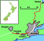
State Highway 1 (New Zealand)
State Highway 1 is the longest and most significant road in the New Zealand roading network, running the length of both main islands. It appears on road maps as SH 1 and on road signs as a white number 1 on a red shield, but it has the official designations SH 1N in the North Island, SH 1S in the...
), formerly (and currently in official land-use planning contexts) called Dunedin Northern Motorway, is a two to four-lane limited-access road
Limited-access road
A limited-access road known by various terms worldwide, including limited-access highway, dual-carriageway and expressway, is a highway or arterial road for high-speed traffic which has many or most characteristics of a controlled-access highway , including limited or no access to adjacent...
which provides the main route north from the city of Dunedin
Dunedin
Dunedin is the second-largest city in the South Island of New Zealand, and the principal city of the Otago Region. It is considered to be one of the four main urban centres of New Zealand for historic, cultural, and geographic reasons. Dunedin was the largest city by territorial land area until...
, New Zealand
New Zealand
New Zealand is an island country in the south-western Pacific Ocean comprising two main landmasses and numerous smaller islands. The country is situated some east of Australia across the Tasman Sea, and roughly south of the Pacific island nations of New Caledonia, Fiji, and Tonga...
. It was constructed in the 1950s to replace narrow, winding routes via Port Chalmers
Port Chalmers
Port Chalmers is a suburb and the main port of the city of Dunedin, New Zealand, with a population of 3,000. Port Chalmers lies ten kilometres inside Otago Harbour, some 15 kilometres northeast from Dunedin's city centre....
and Mount Cargill
Mount Cargill
Mount Cargill is a 680 metre high volcanic outcrop which dominates the skyline of northern Dunedin, New Zealand. It is situated some 15 kilometres north of the city centre....
. The road is occasionally briefly closed by snowfall in winter.
Route
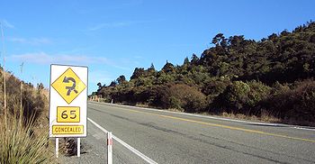
Dunedin-Waitati Highway is relatively steep and winding, traversing part of the SilverpeaksSilverpeaks
The Silverpeaks is an area of rough forest and tussock and scrub covered hill country inland and to the northwest of Dunedin, New Zealand...
range of hills. It begins a short distance north-west from where the two main parts of Dunedin's central business district
Central business district
A central business district is the commercial and often geographic heart of a city. In North America this part of a city is commonly referred to as "downtown" or "city center"...
one-way street system combine near The Gardens Corner
North East Valley
North East Valley is a suburb of the New Zealand city of Dunedin.-Geography and demographics:...
with a pair of bridges over the Water of Leith
Water of Leith, New Zealand
The Water of Leith , is a small river in the South Island of New Zealand.It rises to the north of the city of Dunedin, flowing for 14 kilometres southeast through the northern part of the city and the campus of the University of Otago before reaching the Otago Harbour...
. The highway connects with Bank St and George St
George Street, Dunedin
George Street is the main street of Dunedin, the second largest city in the South Island of New Zealand. It runs for two and a half kilometres north-northeast from The Octagon in the city centre to the foot of Pine Hill. It is straight and undulates gently as it skirts the edge of the hills to its...
then climbs Pine Hill Rd to the northern Dunedin suburb of Pine Hill
Pine Hill, New Zealand
Pine Hill is a suburb, hill, and general area of the New Zealand city of Dunedin. It is sited on the hill of the same name, a spur of Mount Cargill overlooking North East Valley and Glenleith to the north of the city centre. This spur lies in the fork of the confluence of the Water of Leith and...
. From there it follows the northeastern side of the Leith Valley
Leith Valley
Leith Valley is a suburb, valley, and general area of the New Zealand city of Dunedin, located to the northwest of the city centre. To differentiate the name of the valley from that of the suburb, the former is usually referred to as the Leith Valley, the latter simply as Leith Valley.-The valley...
, then crosses the headwaters of the Leith before traversing the Leith Saddle
Leith Saddle
thumb|350px|Leith Saddle near Dunedin, New ZealandLeith Saddle is a saddle between the sources of the Water of Leith and the Waitati River, approximately half way between Dunedin's northern suburb of Pine Hill and the outlying settlement of Waitati. The saddle is a strategic point where the Dunedin...
and taking a roller-coaster-like course to the valley of the Waitati River
Waitati River
The Waitati River is a river in New Zealand, flowing into the Pacific Ocean at Blueskin Bay, north of Dunedin.-References:...
, then to Waitati
Waitati
Waitati is a small seaside settlement in Otago, New Zealand, within the city limits of Dunedin. It is located close to the tidal mudflats of Blueskin Bay, 19 kilometres north of the Dunedin city centre...
. Together with The Kilmog
The Kilmog
The Kilmog is a hilly area approximately 20 kilometres north of Dunedin, New Zealand, on State Highway 1, to the north of Blueskin Bay and south of Karitane...
, a hill 5 kilometres (3.1 mi) north of Waitati, this is one of the two most notable hill sections of State Highway 1 south of Christchurch
Christchurch
Christchurch is the largest city in the South Island of New Zealand, and the country's second-largest urban area after Auckland. It lies one third of the way down the South Island's east coast, just north of Banks Peninsula which itself, since 2006, lies within the formal limits of...
.
'Motorway' status and access
Dunedin-Waitati Highway was officially designated a motorway when it opened and is still colloquially referred to as such. "Motorway" signage was removed and the road lacks any indication of its former status other than "No Cycling/No Pedestrians" signs at Pine Hill and Waitati Valley. Apart from occasional overpassOverpass
An overpass is a bridge, road, railway or similar structure that crosses over another road or railway...
es, it does not resemble a freeway or motorway, rather a two to four-lane undivided limited-access road
Limited-access road
A limited-access road known by various terms worldwide, including limited-access highway, dual-carriageway and expressway, is a highway or arterial road for high-speed traffic which has many or most characteristics of a controlled-access highway , including limited or no access to adjacent...
, and cyclists and pedestrians are allowed on the northern section.
Dunedin-Waitati Highway is a highway in terms of traffic regulations, while the land corridor is designated motorway under the New Zealand Government Roading Powers Act and town planning rules.
There are occasional private property accesses along the 15 km length and two at-grade intersections: one at the Leith Saddle
Leith Saddle
thumb|350px|Leith Saddle near Dunedin, New ZealandLeith Saddle is a saddle between the sources of the Water of Leith and the Waitati River, approximately half way between Dunedin's northern suburb of Pine Hill and the outlying settlement of Waitati. The saddle is a strategic point where the Dunedin...
summit, with Leith Valley Road and Waitati Valley Road, the other at the lower end of Waitati Valley Road. Intersecting roads all have low traffic volumes and are unsealed. All other road crossings are grade separated
Grade separation
Grade separation is the method of aligning a junction of two or more transport axes at different heights so that they will not disrupt the traffic flow on other transit routes when they cross each other. The composition of such transport axes does not have to be uniform; it can consist of a...
on bridges
Overpass
An overpass is a bridge, road, railway or similar structure that crosses over another road or railway...
with no road connections, at Maxwellton Street (which links the suburb of Glenleith with both Pine Hill and the summit of Mount Cargill), Leith Valley Road, Dryden Road, and Pigeon Flat Road; the last of these is the only bridge north of the saddle.
Improvements
Several parts of the highway were realigned or widened around 2000, most notably between the Pigeon Flat Overbridge and the start of the Waitati RiverWaitati River
The Waitati River is a river in New Zealand, flowing into the Pacific Ocean at Blueskin Bay, north of Dunedin.-References:...
floodplain.
Leith Saddle
Transit New Zealand
Transit New Zealand was, from 1989 to 2008, the New Zealand Crown entity responsible for operating and planning the New Zealand State Highway network...
signalled in 2004 its a long term intention to re-align SH1 in the vicinity of Leith Saddle
Leith Saddle
thumb|350px|Leith Saddle near Dunedin, New ZealandLeith Saddle is a saddle between the sources of the Water of Leith and the Waitati River, approximately half way between Dunedin's northern suburb of Pine Hill and the outlying settlement of Waitati. The saddle is a strategic point where the Dunedin...
, which would require some removal of old-growth forest
The forest here features a species of Libocedrus
Libocedrus
Libocedrus is a genus of five species of coniferous trees in the cypress family Cupressaceae, native to New Zealand and New Caledonia. The genus is closely related to the South American genera Pilgerodendron and Austrocedrus, and the New Guinean genus Papuacedrus, both of which are included within...
, variously called Pahautea, Kaikawaka or New Zealand cedar, Libocedrus bidwillii
Libocedrus bidwillii
Libocedrus bidwillii variously called Pāhautea, Kaikawaka or New Zealand cedar is a species of Libocedrus, endemic to New Zealand on both the North and South Islands; on the North Island, it occurs from Te Aroha southward...
, which is unusual in this region of New Zealand.
Transit New Zealand
Transit New Zealand
Transit New Zealand was, from 1989 to 2008, the New Zealand Crown entity responsible for operating and planning the New Zealand State Highway network...
stated in 2004 that Leith Saddle has 250% more accidents than average for the New Zealand State Highway network
New Zealand State Highway network
The New Zealand State Highway network is the major national highway network in New Zealand. Just under 100 roads in both the North and South Islands are State Highways...
and that the accident rate increased by 50% in the ten years to 2004. They said realignment here would reduce traffic delays, fuel use, crashes, and emissions of carbon dioxide
Carbon dioxide
Carbon dioxide is a naturally occurring chemical compound composed of two oxygen atoms covalently bonded to a single carbon atom...
and carbon monoxide
Carbon monoxide
Carbon monoxide , also called carbonous oxide, is a colorless, odorless, and tasteless gas that is slightly lighter than air. It is highly toxic to humans and animals in higher quantities, although it is also produced in normal animal metabolism in low quantities, and is thought to have some normal...
.
Waitati
The motorway originally ended at WaitatiWaitati
Waitati is a small seaside settlement in Otago, New Zealand, within the city limits of Dunedin. It is located close to the tidal mudflats of Blueskin Bay, 19 kilometres north of the Dunedin city centre...
with a roundabout
Roundabout
A roundabout is the name for a road junction in which traffic moves in one direction around a central island. The word dates from the early 20th century. Roundabouts are common in many countries around the world...
, which featured in the New Zealand film Goodbye Pork Pie
Goodbye Pork Pie
Goodbye Pork Pie is a 1981 New Zealand film directed by Geoff Murphy and written by Geoff Murphy and Ian Mune. The film is considered to be one of New Zealand's most popular films, and has been described as Easy Rider meets the Keystone Kops....
. The roundabout has been removed, leaving a sharp curve with a T junction. In 2010, the New Zealand Transport Agency
New Zealand Transport Agency
The New Zealand Transport Agency is a New Zealand Crown entity tasked with promoting safe and functional transport by land, including the responsibility for driver and vehicle licensing and investigating rail accidents. It was created on 1 August 2008 by the Land Transport Management Amendment...
(the successor highway authority
Highway Authority
A highway authority is a name given to a body responsible for the administration of public roads.-India:The National Highways Authority of India is the national authority for the management of a network of over 60,000 km of National Highways in India...
to Transit New Zealand
Transit New Zealand
Transit New Zealand was, from 1989 to 2008, the New Zealand Crown entity responsible for operating and planning the New Zealand State Highway network...
) was given consent to realign the road here.