

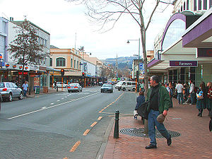
George Street, Dunedin
Encyclopedia
Dunedin
Dunedin is the second-largest city in the South Island of New Zealand, and the principal city of the Otago Region. It is considered to be one of the four main urban centres of New Zealand for historic, cultural, and geographic reasons. Dunedin was the largest city by territorial land area until...
, the second largest city in the South Island
South Island
The South Island is the larger of the two major islands of New Zealand, the other being the more populous North Island. It is bordered to the north by Cook Strait, to the west by the Tasman Sea, to the south and east by the Pacific Ocean...
of New Zealand
New Zealand
New Zealand is an island country in the south-western Pacific Ocean comprising two main landmasses and numerous smaller islands. The country is situated some east of Australia across the Tasman Sea, and roughly south of the Pacific island nations of New Caledonia, Fiji, and Tonga...
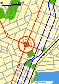
. It runs for two and a half kilometres north-northeast from The Octagon
The Octagon, Dunedin
The Octagon is the city centre of Dunedin, in the South Island of New Zealand.-Features:The Octagon is an eight sided plaza bisected by the city's main street, which is called George Street to the northeast and Princes Street to the southwest...
in the city centre to the foot of Pine Hill
Pine Hill, New Zealand
Pine Hill is a suburb, hill, and general area of the New Zealand city of Dunedin. It is sited on the hill of the same name, a spur of Mount Cargill overlooking North East Valley and Glenleith to the north of the city centre. This spur lies in the fork of the confluence of the Water of Leith and...
. It is straight and undulates gently as it skirts the edge of the hills to its northwest. South of The Octagon, Princes Street
Princes Street, Dunedin
Princes Street is a major street in Dunedin, the second largest city in the South Island of New Zealand. It runs south-southwest for two kilometres from The Octagon in the city centre to the Oval sports ground, close to the city's Southern Cemetery...
continues the line of George Street south-southwest for two kilometres.
History
In the early years of Dunedin's settlement, much of the city's growth was on two areas of reasonably flat land close to the harbour, separated by the large Bell Hill and an area of low swampy land. The northern of these two flat areas surrounded the floodplain of the Water of LeithWater of Leith, New Zealand
The Water of Leith , is a small river in the South Island of New Zealand.It rises to the north of the city of Dunedin, flowing for 14 kilometres southeast through the northern part of the city and the campus of the University of Otago before reaching the Otago Harbour...
, a small river that runs through Dunedin. As the city grew the swamp was drained to become the new city's centre, and the hill was lowered by excavation to allow access between the two areas of settlement. A street grid was set up with the main road split in two by the city centre (now The Octagon
The Octagon, Dunedin
The Octagon is the city centre of Dunedin, in the South Island of New Zealand.-Features:The Octagon is an eight sided plaza bisected by the city's main street, which is called George Street to the northeast and Princes Street to the southwest...
) - Princes Street
Princes Street, Dunedin
Princes Street is a major street in Dunedin, the second largest city in the South Island of New Zealand. It runs south-southwest for two kilometres from The Octagon in the city centre to the Oval sports ground, close to the city's Southern Cemetery...
to the south and George Street to the north. Both these names, along with many of the city's other street names, reflect those in Edinburgh
Edinburgh
Edinburgh is the capital city of Scotland, the second largest city in Scotland, and the eighth most populous in the United Kingdom. The City of Edinburgh Council governs one of Scotland's 32 local government council areas. The council area includes urban Edinburgh and a rural area...
, Scotland
Scotland
Scotland is a country that is part of the United Kingdom. Occupying the northern third of the island of Great Britain, it shares a border with England to the south and is bounded by the North Sea to the east, the Atlantic Ocean to the north and west, and the North Channel and Irish Sea to the...
.
In the settlement's early days, Bell Hill proved a major obstacle to travel south of the city centre, and major excavation work was carried out to provide access to the south. A cutting was made in the hill in 1858, and during the 1860s the hill was lowered by some 14 metres (45.9 ft), much of the rubble forming the start of the Southern Endowment, a large area of land reclaimed from the Otago Harbour
Otago Harbour
Otago Harbour is the natural harbour of Dunedin, New Zealand, consisting of a long, much-indented stretch of generally navigable water separating the Otago Peninsula from the mainland. They join at its southwest end, from the harbour mouth...
to the southeast of the city centre.
Until the early years of the 20th century, George Street stopped at the banks of the Leith at its northern end. A bridge, built in 1903, was one of the city's few bridges to survive disastrous floods in March 1929.
Modern George Street
Central business district
A central business district is the commercial and often geographic heart of a city. In North America this part of a city is commonly referred to as "downtown" or "city center"...
, with the city's civic centre and library occupying much of the first block (the majority of blocks are 200 metres long). Beyond this is a major shopping precinct, including Dunedin's largest shopping mall, the Meridian Mall
Meridian Mall, Dunedin
The Meridian Mall is a large shopping complex in Dunedin, New Zealand designed by ASA Crone Architects, an Australian development company. At it is the largest retail mall in the southern South Island, and one of the largest in the South Island as a whole....
. As the street approaches the northern end of its shopping area, many of the shops have a South East Asian flavour, in part due to the large proportion of Malaysian and Chinese students at the University of Otago
University of Otago
The University of Otago in Dunedin is New Zealand's oldest university with over 22,000 students enrolled during 2010.The university has New Zealand's highest average research quality and in New Zealand is second only to the University of Auckland in the number of A rated academic researchers it...
, some 500 metres to the east.
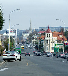
At the northern end of the main shopping area the skyline is dominated by the spire of Knox Church
Knox Church, Dunedin
Knox Church is a notable building in Dunedin, New Zealand. It houses the city's second Presbyterian congregation and is the city's largest church of any denomination. Situated close to the university at the northern end of the CBD on George Street it is visible from much of the central city.It was...
, designed by R. A. Lawson
Robert Lawson (architect)
Robert Arthur Lawson was one of New Zealand's pre-eminent 19th century architects. It has been said he did more than any other designer to shape the face of the Victorian era architecture of the city of Dunedin...
. Beyond this is a mix of older residential houses and hotels. Many of Dunedin's more attractive inner city properties are at the north end of the street, quite a number of which have been divided up as student flats. At its northern end is the entrance to Woodhaugh Gardens, a major park, which lies to the west of George Street along the southern bank of the Leith. George Street continues over the Leith, ending as it passes under the Pine Hill Extension (part of State Highway 1). Beyond this bridge the street leads into Bank Street, a suburban arterial road, turning to the east before reaching a major junction at The Gardens
North East Valley
North East Valley is a suburb of the New Zealand city of Dunedin.-Geography and demographics:...
.