

Leith Valley
Encyclopedia
Leith Valley is a suburb, valley, and general area of the New Zealand
city of Dunedin
, located to the northwest of the city centre. To differentiate the name of the valley from that of the suburb, the former is usually referred to as the Leith Valley, the latter simply as Leith Valley.
a 14 kilometres (8.7 mi) long stream which flows from the slopes of Mount Cargill
south through the northern suburbs of Dunedin. The valley starts close to a saddle, Pigeon Flat, between it and the valley of the Waitati River
, which is crossed by the Dunedin Northern Motorway
. The motorway follows the flank of Mount Cargill's spur Pine Hill
, which forms the northern boundary of the valley. The southern boundary is formed by Maori Hill
, the northernmost part of a long ridge which forms a crescent around central Dunedin, culminating at Lookout Point in the city's southwest.
The valley starts steeply in bush
-clad countryside, before widening into a narrow flood plain occupied by the start of Dunedin's suburban area. The valley widens, and is hemmed in by steep slopes and occasional cliff faces before joining the northern end of the wide plain which is the location of Dunedin's CBD
some 2 kilometres (1.2 mi) from the coast. At its mouth, the valley is some 400 metres (1,312.3 ft) in width.
Much of Dunedin's water supply comes from reservoirs in the upper reaches of the Leith Valley. These include Ross Creek Reservoir
, the oldest reservoir still in active use in New Zealand, and Sullivans Dam. Numerous popular walking tracks traverse the bush-clad reserve land surrounding this reservoir.
. At its southern end, Leith Valley Road becomes Malvern Street, the main route through Glenleith.
The main road through Glenleith is Malvern Street, which runs from the Leith Valley Road in the upper valley to meet with Duke Street in Woodhaugh. Most of Glenleith's residences are located either on this street or around Fulton Road, a steep street which rises from Malvern Street, passing through forestry
plantations before joining the end of Wakari Road near Helensburgh. A third main road, Rockside Road, runs from Malvern Street close to the boundary between Glenleith and Woodhaugh, winding uphill through the same plantations before becoming Tanner Road and joining with Wakari Road.
These plantations contain numerous walking tracks, and also contain the historically listed
Ross Creek Reservoir
, constructed in the late 1860s. The walking tracks circumnavigate the dam, as well as following the banks of the Ross Creek and School Creek, two small tributaries of the Leith.
Another major walking track, the Pineapple Track, has its northeastern end close to Fulton Road. This track traverses Flagstaff
, a 650 metres (2,132.5 ft) hill which dominates the city's western skyline.
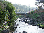 Woodhaugh is the suburban part of the Leith Valley which lies below the Rockside Road intersection. At its top, it houses numerous older stone buildings, many of them of some historical significance. Lower down, the suburb is dominated by Woodhaugh Gardens, a large area of parkland and trees that forms part of Dunedin's Town Belt
. Once a quarry, this is one of the city's oldest parks, dating from 1895.
The area around the park is known as Woodhaugh and is a popular area for student accommodation, as it is only 15 minute walk to the university and the centre of the city. Most of Woodhaugh's residential area lies on Malvern Street, on Woodhaugh Street, a crescent in the upper part of the suburb, or on the small number of short streets close to the valley's mouth. At this point, Malvern Street becomes Duke Street, which intersects with the city's main commercial street, George Street
at the valley's mouth. The suburb's only retail outlet, a dairy and grocery store, is located at the junction of Duke Street and George Street.
A series of walkways runs through Woodhaugh Gardens and along the banks of the Leith. One of these follows the course of the stream from the northern end of Woodhaugh Gardens to connect with the Ross Creek tracks, passing as it does a major weir (the Boulder Trap) which was put in to prevent a repeat of the major flooding of the Leith in the early 20th century. The walkway also passes the remains of the former Woodhaugh Quarry, which operated until 1949.
The sides of the Leith Valley are notably steep, especially in the area around the start of Rockside Road (also the location of the confluence of the Ross Creek and Leith). At this point, steep cliffs flank the valley, and nearby the Ross Creek passes through a narrow canyon. In the lower reaches of the valley, the valley's walls are still steep, though not vertical. The Dunedin Northern Motorway skirts the northern edge as it passes by the suburb of Dalmore, and along the southern edge of the valley, a walking track rises sharply, connecting Woodhaugh with Prospect Park, New Zealand. This track, the Bullock track, was originally part of a trail used by farmers taking cattle from the farms of North East Valley
to abattoirs in Burnside, Otago
.
pumphouse, and a former public house on the corner of Malvern Street and Woodhaugh Street, close to the bridge carrying Malvern Street over the Leith. This building operated as a public house between 1888 and 1892.
Woodhaugh Gardens is home to the Leith valley Bowling Club, one of the city's main lawn bowls clubs.
New Zealand
New Zealand is an island country in the south-western Pacific Ocean comprising two main landmasses and numerous smaller islands. The country is situated some east of Australia across the Tasman Sea, and roughly south of the Pacific island nations of New Caledonia, Fiji, and Tonga...
city of Dunedin
Dunedin
Dunedin is the second-largest city in the South Island of New Zealand, and the principal city of the Otago Region. It is considered to be one of the four main urban centres of New Zealand for historic, cultural, and geographic reasons. Dunedin was the largest city by territorial land area until...
, located to the northwest of the city centre. To differentiate the name of the valley from that of the suburb, the former is usually referred to as the Leith Valley, the latter simply as Leith Valley.
The valley itself
As its name suggests, it is the valley of the Water of LeithWater of Leith, New Zealand
The Water of Leith , is a small river in the South Island of New Zealand.It rises to the north of the city of Dunedin, flowing for 14 kilometres southeast through the northern part of the city and the campus of the University of Otago before reaching the Otago Harbour...
a 14 kilometres (8.7 mi) long stream which flows from the slopes of Mount Cargill
Mount Cargill
Mount Cargill is a 680 metre high volcanic outcrop which dominates the skyline of northern Dunedin, New Zealand. It is situated some 15 kilometres north of the city centre....
south through the northern suburbs of Dunedin. The valley starts close to a saddle, Pigeon Flat, between it and the valley of the Waitati River
Waitati River
The Waitati River is a river in New Zealand, flowing into the Pacific Ocean at Blueskin Bay, north of Dunedin.-References:...
, which is crossed by the Dunedin Northern Motorway
Dunedin Northern Motorway
Dunedin-Waitati Highway , formerly called Dunedin Northern Motorway, is a two to four-lane limited-access road which provides the main route north from the city of Dunedin, New Zealand. It was constructed in the 1950s to replace narrow, winding routes via Port Chalmers and Mount Cargill...
. The motorway follows the flank of Mount Cargill's spur Pine Hill
Pine Hill, New Zealand
Pine Hill is a suburb, hill, and general area of the New Zealand city of Dunedin. It is sited on the hill of the same name, a spur of Mount Cargill overlooking North East Valley and Glenleith to the north of the city centre. This spur lies in the fork of the confluence of the Water of Leith and...
, which forms the northern boundary of the valley. The southern boundary is formed by Maori Hill
Maori Hill
Maori Hill is a residential suburb of the New Zealand city of Dunedin. It is located at the northern end of the ridge which runs in a crescent around the central city's western edge, to the northwest of the city centre, immediately above and within the Town Belt...
, the northernmost part of a long ridge which forms a crescent around central Dunedin, culminating at Lookout Point in the city's southwest.
The valley starts steeply in bush
The Bush
"The bush" is a term used for rural, undeveloped land or country areas in certain countries.-Australia:The term is iconic in Australia. In reference to the landscape, "bush" describes a wooded area, intermediate between a shrubland and a forest, generally of dry and nitrogen-poor soil, mostly...
-clad countryside, before widening into a narrow flood plain occupied by the start of Dunedin's suburban area. The valley widens, and is hemmed in by steep slopes and occasional cliff faces before joining the northern end of the wide plain which is the location of Dunedin's CBD
Central business district
A central business district is the commercial and often geographic heart of a city. In North America this part of a city is commonly referred to as "downtown" or "city center"...
some 2 kilometres (1.2 mi) from the coast. At its mouth, the valley is some 400 metres (1,312.3 ft) in width.
Much of Dunedin's water supply comes from reservoirs in the upper reaches of the Leith Valley. These include Ross Creek Reservoir
Ross Creek Reservoir
The Ross Creek Reservoir is an artificial lake in Dunedin, New Zealand. One of the oldest artificial lakes in the country, and the oldest water supply reservoir still in use in the country, it was created in the 1860s to provide water for the city of Dunedin, at that time in the middle of rapid...
, the oldest reservoir still in active use in New Zealand, and Sullivans Dam. Numerous popular walking tracks traverse the bush-clad reserve land surrounding this reservoir.
The suburbs
The term "Leith Valley" can be used to refer to the semi-rural settlement which lies in the upper reaches of the valley, or - more generally - for both this community and the two suburbs which lie in the lower valley, Glenleith and Woodhaugh.Leith Valley
Leith Valley is as much a rural settlement as a suburb, though it does lie within the Dunedin city boundaries very close to the edge of the city's main urban area. It is connected by Leith Valley Road, which follows the course of the river, crossing the Dunedin Northern Motorway by bridge towards its northern end. From here it runs roughly parallel with both the river and motorway before connecting with the latter at the Leith SaddleLeith Saddle
thumb|350px|Leith Saddle near Dunedin, New ZealandLeith Saddle is a saddle between the sources of the Water of Leith and the Waitati River, approximately half way between Dunedin's northern suburb of Pine Hill and the outlying settlement of Waitati. The saddle is a strategic point where the Dunedin...
. At its southern end, Leith Valley Road becomes Malvern Street, the main route through Glenleith.
Glenleith
The main suburban area within the Leith valley is roughly split into two suburbs - Glenleith in the upper valley and Woodhaugh close to the valley's mouth. The two suburbs, and particularly Glenleith, were both heavily industrialised during the early years of Dunedin, with the power of the Leith being harnessed for sawmills from 1850 and for flour mills shortly thereafter. The first commercial paper mill in New Zealand was located in the valley, the last overgrown remains of which can still be seen close to a walking track.The main road through Glenleith is Malvern Street, which runs from the Leith Valley Road in the upper valley to meet with Duke Street in Woodhaugh. Most of Glenleith's residences are located either on this street or around Fulton Road, a steep street which rises from Malvern Street, passing through forestry
Forestry
Forestry is the interdisciplinary profession embracing the science, art, and craft of creating, managing, using, and conserving forests and associated resources in a sustainable manner to meet desired goals, needs, and values for human benefit. Forestry is practiced in plantations and natural stands...
plantations before joining the end of Wakari Road near Helensburgh. A third main road, Rockside Road, runs from Malvern Street close to the boundary between Glenleith and Woodhaugh, winding uphill through the same plantations before becoming Tanner Road and joining with Wakari Road.
These plantations contain numerous walking tracks, and also contain the historically listed
New Zealand Historic Places Trust
The New Zealand Historic Places Trust is a non-profit trust that advocates for the protection of ancestral sites and heritage buildings in New Zealand...
Ross Creek Reservoir
Ross Creek Reservoir
The Ross Creek Reservoir is an artificial lake in Dunedin, New Zealand. One of the oldest artificial lakes in the country, and the oldest water supply reservoir still in use in the country, it was created in the 1860s to provide water for the city of Dunedin, at that time in the middle of rapid...
, constructed in the late 1860s. The walking tracks circumnavigate the dam, as well as following the banks of the Ross Creek and School Creek, two small tributaries of the Leith.
Another major walking track, the Pineapple Track, has its northeastern end close to Fulton Road. This track traverses Flagstaff
Flagstaff, Otago
Flagstaff is a prominent hill overlooking the northwest of the city of Dunedin, in New Zealand's South Island. Together with Mount Cargill, which lies to its northeast, it dominates the skyline of the city...
, a 650 metres (2,132.5 ft) hill which dominates the city's western skyline.
Woodhaugh
Town Belt
The Town Belt is a green belt which surrounds the centre of the New Zealand city of Dunedin. Covering a total of over , it extends around three sides of the city's centre at a distance from it of some 1-3 km in a broad crescent from the Oval at Kensington in the south through the suburbs of...
. Once a quarry, this is one of the city's oldest parks, dating from 1895.
The area around the park is known as Woodhaugh and is a popular area for student accommodation, as it is only 15 minute walk to the university and the centre of the city. Most of Woodhaugh's residential area lies on Malvern Street, on Woodhaugh Street, a crescent in the upper part of the suburb, or on the small number of short streets close to the valley's mouth. At this point, Malvern Street becomes Duke Street, which intersects with the city's main commercial street, George Street
George Street, Dunedin
George Street is the main street of Dunedin, the second largest city in the South Island of New Zealand. It runs for two and a half kilometres north-northeast from The Octagon in the city centre to the foot of Pine Hill. It is straight and undulates gently as it skirts the edge of the hills to its...
at the valley's mouth. The suburb's only retail outlet, a dairy and grocery store, is located at the junction of Duke Street and George Street.
A series of walkways runs through Woodhaugh Gardens and along the banks of the Leith. One of these follows the course of the stream from the northern end of Woodhaugh Gardens to connect with the Ross Creek tracks, passing as it does a major weir (the Boulder Trap) which was put in to prevent a repeat of the major flooding of the Leith in the early 20th century. The walkway also passes the remains of the former Woodhaugh Quarry, which operated until 1949.
The sides of the Leith Valley are notably steep, especially in the area around the start of Rockside Road (also the location of the confluence of the Ross Creek and Leith). At this point, steep cliffs flank the valley, and nearby the Ross Creek passes through a narrow canyon. In the lower reaches of the valley, the valley's walls are still steep, though not vertical. The Dunedin Northern Motorway skirts the northern edge as it passes by the suburb of Dalmore, and along the southern edge of the valley, a walking track rises sharply, connecting Woodhaugh with Prospect Park, New Zealand. This track, the Bullock track, was originally part of a trail used by farmers taking cattle from the farms of North East Valley
North East Valley
North East Valley is a suburb of the New Zealand city of Dunedin.-Geography and demographics:...
to abattoirs in Burnside, Otago
Burnside, Otago
Burnside is a mainly industrial suburb of the New Zealand city of Dunedin. It is located at the mouth of a long valley, the Kaikorai Valley, through which flows the Kaikorai Stream. This valley stretches to the northeast for . Burnside is to the southwest of the city centre, close to eastern end...
.
Notable features
Notable buildings in the Leith Valley include the Ross Creek ReservoirRoss Creek Reservoir
The Ross Creek Reservoir is an artificial lake in Dunedin, New Zealand. One of the oldest artificial lakes in the country, and the oldest water supply reservoir still in use in the country, it was created in the 1860s to provide water for the city of Dunedin, at that time in the middle of rapid...
pumphouse, and a former public house on the corner of Malvern Street and Woodhaugh Street, close to the bridge carrying Malvern Street over the Leith. This building operated as a public house between 1888 and 1892.
Woodhaugh Gardens is home to the Leith valley Bowling Club, one of the city's main lawn bowls clubs.