

Leith Saddle
Encyclopedia
Mountain pass
A mountain pass is a route through a mountain range or over a ridge. If following the lowest possible route, a pass is locally the highest point on that route...
between the sources of the Water of Leith
Water of Leith, New Zealand
The Water of Leith , is a small river in the South Island of New Zealand.It rises to the north of the city of Dunedin, flowing for 14 kilometres southeast through the northern part of the city and the campus of the University of Otago before reaching the Otago Harbour...
and the Waitati River
Waitati River
The Waitati River is a river in New Zealand, flowing into the Pacific Ocean at Blueskin Bay, north of Dunedin.-References:...
, approximately half way between Dunedin
Dunedin
Dunedin is the second-largest city in the South Island of New Zealand, and the principal city of the Otago Region. It is considered to be one of the four main urban centres of New Zealand for historic, cultural, and geographic reasons. Dunedin was the largest city by territorial land area until...
's northern suburb of Pine Hill
Pine Hill, New Zealand
Pine Hill is a suburb, hill, and general area of the New Zealand city of Dunedin. It is sited on the hill of the same name, a spur of Mount Cargill overlooking North East Valley and Glenleith to the north of the city centre. This spur lies in the fork of the confluence of the Water of Leith and...
and the outlying settlement of Waitati
Waitati
Waitati is a small seaside settlement in Otago, New Zealand, within the city limits of Dunedin. It is located close to the tidal mudflats of Blueskin Bay, 19 kilometres north of the Dunedin city centre...
. The saddle is a strategic point where the Dunedin Northern Motorway
Dunedin Northern Motorway
Dunedin-Waitati Highway , formerly called Dunedin Northern Motorway, is a two to four-lane limited-access road which provides the main route north from the city of Dunedin, New Zealand. It was constructed in the 1950s to replace narrow, winding routes via Port Chalmers and Mount Cargill...
, part of State Highway 1
State Highway 1 (New Zealand)
State Highway 1 is the longest and most significant road in the New Zealand roading network, running the length of both main islands. It appears on road maps as SH 1 and on road signs as a white number 1 on a red shield, but it has the official designations SH 1N in the North Island, SH 1S in the...
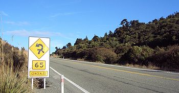
traverses a fragile alpine forest. Proposed road works to straighten a dangerous corner here conflict with conservation values. Water supply
Water supply
Water supply is the provision of water by public utilities, commercial organisations, community endeavours or by individuals, usually via a system of pumps and pipes...
pipelines, and popular tramping
Hiking
Hiking is an outdoor activity which consists of walking in natural environments, often in mountainous or other scenic terrain. People often hike on hiking trails. It is such a popular activity that there are numerous hiking organizations worldwide. The health benefits of different types of hiking...
and cycling
Cycling
Cycling, also called bicycling or biking, is the use of bicycles for transport, recreation, or for sport. Persons engaged in cycling are cyclists or bicyclists...
routes also converge at the saddle.
The Water of Leith
Water of Leith, New Zealand
The Water of Leith , is a small river in the South Island of New Zealand.It rises to the north of the city of Dunedin, flowing for 14 kilometres southeast through the northern part of the city and the campus of the University of Otago before reaching the Otago Harbour...
's source is 100 metres to the south of Leith Saddle, at a height of 380 metres above sea level.
The Leith Saddle Track is a 3.5 hour climb through native cloud forest
Cloud forest
A cloud forest, also called a fog forest, is a generally tropical or subtropical evergreen montane moist forest characterized by a persistent, frequent or seasonal low-level cloud cover, usually at the canopy level. Cloud forests often exhibit an abundance of mosses covering the ground and...
to Swampy Spur and Swampy Summit with links to other walkways in the Silverpeaks
Silverpeaks
The Silverpeaks is an area of rough forest and tussock and scrub covered hill country inland and to the northwest of Dunedin, New Zealand...
and Dunedin's hills.
The Dunedin Northern Motorway has an at-grade intersection at the Leith Saddle summit with Leith Valley Road and Waitati Valley Road. Both have low motor vehicle volumes and have metalled surfaces, making them attractive to cyclists.
Transit New Zealand
Transit New Zealand
Transit New Zealand was, from 1989 to 2008, the New Zealand Crown entity responsible for operating and planning the New Zealand State Highway network...
signalled a long term intention in 2004 to realign SH1 in the vicinity of Leith Saddle; construction would require removal of some old-growth forest.

Libocedrus
Libocedrus is a genus of five species of coniferous trees in the cypress family Cupressaceae, native to New Zealand and New Caledonia. The genus is closely related to the South American genera Pilgerodendron and Austrocedrus, and the New Guinean genus Papuacedrus, both of which are included within...
, variously called Pahautea, Kaikawaka or New Zealand cedar, Libocedrus bidwillii
Libocedrus bidwillii
Libocedrus bidwillii variously called Pāhautea, Kaikawaka or New Zealand cedar is a species of Libocedrus, endemic to New Zealand on both the North and South Islands; on the North Island, it occurs from Te Aroha southward...
, which is unusual in this region of New Zealand.
Transit New Zealand
Transit New Zealand
Transit New Zealand was, from 1989 to 2008, the New Zealand Crown entity responsible for operating and planning the New Zealand State Highway network...
stated in 2004 that Leith Saddle has 250% more accidents than average for the New Zealand State Highway network
New Zealand State Highway network
The New Zealand State Highway network is the major national highway network in New Zealand. Just under 100 roads in both the North and South Islands are State Highways...
and that the accident rate increased by 50% in the ten years to 2004. They said realignment here would reduce traffic delays, fuel use, crashes, and emissions of carbon dioxide
Carbon dioxide
Carbon dioxide is a naturally occurring chemical compound composed of two oxygen atoms covalently bonded to a single carbon atom...
and carbon monoxide
Carbon monoxide
Carbon monoxide , also called carbonous oxide, is a colorless, odorless, and tasteless gas that is slightly lighter than air. It is highly toxic to humans and animals in higher quantities, although it is also produced in normal animal metabolism in low quantities, and is thought to have some normal...
.
A contour pipeline running southbound over the saddle from several tributaries of the Waitati River
Waitati River
The Waitati River is a river in New Zealand, flowing into the Pacific Ocean at Blueskin Bay, north of Dunedin.-References:...
feeds two of Dunedin's water supply reservoirs in Leith Valley
Leith Valley
Leith Valley is a suburb, valley, and general area of the New Zealand city of Dunedin, located to the northwest of the city centre. To differentiate the name of the valley from that of the suburb, the former is usually referred to as the Leith Valley, the latter simply as Leith Valley.-The valley...
: Ross Creek Reservoir
Ross Creek Reservoir
The Ross Creek Reservoir is an artificial lake in Dunedin, New Zealand. One of the oldest artificial lakes in the country, and the oldest water supply reservoir still in use in the country, it was created in the 1860s to provide water for the city of Dunedin, at that time in the middle of rapid...
and Sullivans Dam. Treated, fluoridated water is transmitted northwards from Dunedin's municipal water system via a new pipeline to the rural settlements of Waitati
Waitati
Waitati is a small seaside settlement in Otago, New Zealand, within the city limits of Dunedin. It is located close to the tidal mudflats of Blueskin Bay, 19 kilometres north of the Dunedin city centre...
, Warrington
Warrington, New Zealand
Warrington is a small settlement on the coast of Otago, in the South Island of New Zealand. It is situated close to the northern shore of Blueskin Bay, an area of mudflats north of Dunedin and is administered as part of Dunedin City. Warrington is 3 km from State Highway 1 linked by Coast Road...
and Seacliff
Seacliff, New Zealand
Seacliff is a small village located north of Dunedin in the Otago region of New Zealand's South Island. The village lies roughly half way between the estuary of Blueskin Bay and the mouth of the Waikouaiti River at Karitane, on the eastern slopes of Kilmog hill...
.