

Dufton
Encyclopedia
Dufton is a village and civil parish in Cumbria
, England
. It lies in the Eden Valley
and below Great Dun Fell
. It is mostly around 180m above sea level. At the 2001 census the parish had a population of 169.
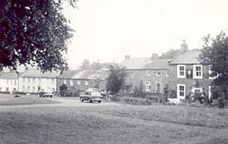
The centre of the village is built around a green, on the north side of which is the Stag Inn. The village green is oblong in shape and is bisected by an avenue of lime trees that crosses it diagonally. Houses in the village were built from the 17th century onwards and the village has changed little over the last 100 years.
 Dufton is an ancient settlement and the earliest written records of the village are from the 1320s. The Rolls of Appointment report the “living” of the parish
of Dufton in 1323. The current church of St Cuthbert in the village mainly dates from the 19th century.
Dufton was a centre for lead mining in the 18th and 19th centuries. The London Lead Company
(Quaker-owned) developed the village through the construction of housing, a school, a library and the installation of piped water. A fountain and circular water trough built by the Company forms a centrepiece on the green. The inscription on the fountain reads (translated from the Latin):
There is a clear pool, whose waters gleam like silver. It is not tainted by shepherds, or by their she-goats grazing on the mountain. Nor is it muddied by cattle, or by birds or wild animals, or by a branch fallen from a tree
The village has an active Parish Council and a single general shop.
Dufton lies on the Pennine Way
and both the Stag Inn and Dufton Youth Hostel
. are favourite stopping-off points for walkers. The Hostel was opened in 1978 following the closure of nearby Knock YHA which was located in an old RAF station. There are several B&Bs and campsites in and around the village.
The advent of the internet has allowed some small service businesses to locate in the village. These include at least one IT company.
Dufton Ghyll
Wood is an area of semi-natural ancient woodland
that contains significant outcrops of St Bees Sandstone
. Other local geographic features include Dufton Pike, Knock Pike, Cross Fell
and High Cup. The locality is also known for the Helm Wind
and Helm Bar. The latter are wind and cloud effects induced by the topography of the area.
Cumbria
Cumbria , is a non-metropolitan county in North West England. The county and Cumbria County Council, its local authority, came into existence in 1974 after the passage of the Local Government Act 1972. Cumbria's largest settlement and county town is Carlisle. It consists of six districts, and in...
, England
England
England is a country that is part of the United Kingdom. It shares land borders with Scotland to the north and Wales to the west; the Irish Sea is to the north west, the Celtic Sea to the south west, with the North Sea to the east and the English Channel to the south separating it from continental...
. It lies in the Eden Valley
Eden Valley
Eden Valley may refer to:* the valley of various rivers called River Eden* Eden Valley 216 in Alberta, Canada* Eden Valley in Mendocino County* Eden Valley, South Australia in Australia* Eden Valley, Minnesota in the United States of America...
and below Great Dun Fell
Great Dun Fell
Great Dun Fell is the second-highest hill in the Pennine range, United Kingdom, lying two miles south along the watershed from Cross Fell, its higher neighbour...
. It is mostly around 180m above sea level. At the 2001 census the parish had a population of 169.
The centre of the village is built around a green, on the north side of which is the Stag Inn. The village green is oblong in shape and is bisected by an avenue of lime trees that crosses it diagonally. Houses in the village were built from the 17th century onwards and the village has changed little over the last 100 years.
History
Parish
A parish is a territorial unit historically under the pastoral care and clerical jurisdiction of one parish priest, who might be assisted in his pastoral duties by a curate or curates - also priests but not the parish priest - from a more or less central parish church with its associated organization...
of Dufton in 1323. The current church of St Cuthbert in the village mainly dates from the 19th century.
Dufton was a centre for lead mining in the 18th and 19th centuries. The London Lead Company
London Lead Company
The London Lead Company was an 18th and 19th century British lead mining company. It was incorporated by royal charter. Strictly, it was The Company for Smelting Down Lead with Pitcoal.-Origins:...
(Quaker-owned) developed the village through the construction of housing, a school, a library and the installation of piped water. A fountain and circular water trough built by the Company forms a centrepiece on the green. The inscription on the fountain reads (translated from the Latin):
There is a clear pool, whose waters gleam like silver. It is not tainted by shepherds, or by their she-goats grazing on the mountain. Nor is it muddied by cattle, or by birds or wild animals, or by a branch fallen from a tree
Dufton today
The main activities in the village nowadays are linked to tourism and farming. Dufton was badly affected by the foot and mouth disease outbreak of 2001. Local farms were in the area which became known as "the Penrith spur" where the disease proved very hard to eradicate and where the final cases of the outbreak occurred. The practice of grazing sheep on communal pastureland above the village may have contributed to this.The village has an active Parish Council and a single general shop.
Dufton lies on the Pennine Way
Pennine Way
The Pennine Way is a National Trail in England. The trail runs from Edale, in the northern Derbyshire Peak District, north through the Yorkshire Dales and the Northumberland National Park and ends at Kirk Yetholm, just inside the Scottish border. The path runs along the Pennine hills, sometimes...
and both the Stag Inn and Dufton Youth Hostel
Youth Hostels Association (England & Wales)
The Youth Hostels Association is a charitable organisation, registered with the Charity Commission, providing youth hostel accommodation in England and Wales...
. are favourite stopping-off points for walkers. The Hostel was opened in 1978 following the closure of nearby Knock YHA which was located in an old RAF station. There are several B&Bs and campsites in and around the village.
The advent of the internet has allowed some small service businesses to locate in the village. These include at least one IT company.
Dufton Ghyll
Gill (stream)
Ghyll or Gill is used for a stream or narrow valley in the North of England and other parts of the United Kingdom. The word originates from the Old Norse Gil...
Wood is an area of semi-natural ancient woodland
Ancient woodland
Ancient woodland is a term used in the United Kingdom to refer specifically to woodland that has existed continuously since 1600 or before in England and Wales . Before those dates, planting of new woodland was uncommon, so a wood present in 1600 was likely to have developed naturally...
that contains significant outcrops of St Bees Sandstone
Sandstone
Sandstone is a sedimentary rock composed mainly of sand-sized minerals or rock grains.Most sandstone is composed of quartz and/or feldspar because these are the most common minerals in the Earth's crust. Like sand, sandstone may be any colour, but the most common colours are tan, brown, yellow,...
. Other local geographic features include Dufton Pike, Knock Pike, Cross Fell
Cross Fell
Cross Fell is the highest point in the Pennine Hills of northern England and the highest point in England outside of the Lake District.The summit, at , is a stony plateau, part of a long ridge running North West to South East, which also incorporates Little Dun Fell at and Great Dun Fell at...
and High Cup. The locality is also known for the Helm Wind
Helm Wind
The Helm Wind is a named wind in Cumbria, England, a strong north-easterly wind which blows down the south-west slope of the Cross Fell escarpment. It is the only named wind in the British Isles, although many other mountain regions in Britain exhibit the same phenomenon when the weather conditions...
and Helm Bar. The latter are wind and cloud effects induced by the topography of the area.