

Downtown Santo Domingo
Encyclopedia
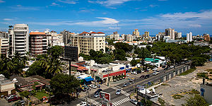
Downtown Santo Domingo or better known as Polígono Central (Central Polygon) is a term used to group several neighborhoods located in central Santo Domingo
, D.N, Dominican Republic
defined as the area delineated by John F Kennedy Avenue (also known as DR-1
) on the north , on the west by Wiston Churchill avenue, on the east by Maximo Gomez avenue, and on the south by 27 de Febrero avenue (also known as DR-3
).
The downtown area forms the core of the city of Santo Domingo which includes the neighborhoods of Naco, Piantini, Paraiso, and Yolanda Morales. This central polygon, as the name implies, serves as the main economic and business center of the city. The neighborhoods within the bounds of Downtown are granted higher-desinty zoning by the Ayuntamiento del Distrito Nacional. Some of the most affluent neighborhoods of Santo Domingo
are located within the downtown even as growth has overflowed to other locations outside the area. Piantini, Naco, & Paraiso all experience high levels of urbanization and better than average quality of life. The area is mostly composed of mixed-development zoning having most of the commercial zoning on the main avenues while having mostly residential zoning in the inner streets.
Some of the most important avenues of the city are located in the Polígono Central including Wiston Churchill avenue with very high banking and commercial activity, and Abraham Lincoln avenue serving as the main thoroughfare of the city-center. Since the late 1990s a general trend of vertical growth has been experienced throughout the area creating complications of traffic and lack of appropriate infrastructure to handle the higher density levels. Most of Downtown Santo Domingo wasn't really planned to handle high-rise office and residential buildings and until the late 1990s it was mostly composed of large family homes and low-rise buildings. Rapid urbanization has led to solutions like the new Santo Domingo Metro
and the creation of two express urban corridors to the north and south of Downtown.
and the 1986 Central American and Caribbean Games
were hosted. Popular events like the Festival Presidente de la Musica Latina
and concerts by The Jonas Brothers, The Killers, Maroon 5
, La Ley
, Shakira
, Tiesto
, and many other bands have taken place in the Estadio Olimpico Felix Sanchez in the COJPD.
on the intersections of Maximo Gomez with DR-1
and DR-3
. Currently on construction is line 2 of the system which will have stops along Expreso John F Kennedy and avenues Wiston Churchill, Abraham Lincoln, Lope de Vega, & Ortega & Gasset. In the near future, the construction of line 3 of the metro system along Expreso 27 de Febrero (DR-3) will enclose Downtown Santo Domingo with full mass transportation access.
a relieve to the current chaos could be accomplished
and banks in the city including Multicentro La Sirena/Super Pola, Mall at the Acropolis, Blue Mall, Supermercado Bravo and locations of Scotiabank
, Citibank
, Banreservas, Banco del Progreso and a significant amount of international fast food
chains.
Abraham Lincoln avenue is North-South avenue in the core of Downtown Santo Domingo. It serves as the major thoroughfare of the center and services the neighborhoods of Piantini, Naco, Yolanda Morales, Paraiso, and Seralles. A major avenue for business and offices and a variety of Shopping plazas are also located in the avenue. Lope De Vega avenue starts out in Abraham Lincoln avenue and splits off in a Northeast direction towards John F Kennedy avenue
is the eastern border of Downtown Santo Domingo.
named Expreso John F Kennedy runs through the north of Downtown Santo Domingo. It is composed of a series of elevated express viaduct which run above the intersection of Wiston Churchill, Abraham Lincoln, Lope De Vega, Tiradentes, and Ortega & Gasset avenues. An underpass under Maximo Gomez completes John F Kennedy as an urban corridor. To the west of Downtown Santo Domingo the corridor become highway Juan Pablo Duarte and to the east it becomes Expreso Quinto Centenario.
Santo Domingo
Santo Domingo, known officially as Santo Domingo de Guzmán, is the capital and largest city in the Dominican Republic. Its metropolitan population was 2,084,852 in 2003, and estimated at 3,294,385 in 2010. The city is located on the Caribbean Sea, at the mouth of the Ozama River...
, D.N, Dominican Republic
Dominican Republic
The Dominican Republic is a nation on the island of La Hispaniola, part of the Greater Antilles archipelago in the Caribbean region. The western third of the island is occupied by the nation of Haiti, making Hispaniola one of two Caribbean islands that are shared by two countries...
defined as the area delineated by John F Kennedy Avenue (also known as DR-1
DR-1
DR-1 is a dual carriageway highway that forms part of the five designated national highways of the Dominican Republic. DR-1 provides a fast connection between Santo Domingo, the capital, on the southern coast, and the second city Santiago and the rest of the northerly Cibao region, one of the...
) on the north , on the west by Wiston Churchill avenue, on the east by Maximo Gomez avenue, and on the south by 27 de Febrero avenue (also known as DR-3
DR-3
DR-3 is one of three main dual carriageway highways of the Dominican Republic, connecting Santo Domingo to the eastern cities of the republic. The highway begins at the Plaza de La Bandera, on the western side of Santo Domingo, and travels eastward through downtown Santo Domingo and continues east...
).
The downtown area forms the core of the city of Santo Domingo which includes the neighborhoods of Naco, Piantini, Paraiso, and Yolanda Morales. This central polygon, as the name implies, serves as the main economic and business center of the city. The neighborhoods within the bounds of Downtown are granted higher-desinty zoning by the Ayuntamiento del Distrito Nacional. Some of the most affluent neighborhoods of Santo Domingo
Santo Domingo
Santo Domingo, known officially as Santo Domingo de Guzmán, is the capital and largest city in the Dominican Republic. Its metropolitan population was 2,084,852 in 2003, and estimated at 3,294,385 in 2010. The city is located on the Caribbean Sea, at the mouth of the Ozama River...
are located within the downtown even as growth has overflowed to other locations outside the area. Piantini, Naco, & Paraiso all experience high levels of urbanization and better than average quality of life. The area is mostly composed of mixed-development zoning having most of the commercial zoning on the main avenues while having mostly residential zoning in the inner streets.
Some of the most important avenues of the city are located in the Polígono Central including Wiston Churchill avenue with very high banking and commercial activity, and Abraham Lincoln avenue serving as the main thoroughfare of the city-center. Since the late 1990s a general trend of vertical growth has been experienced throughout the area creating complications of traffic and lack of appropriate infrastructure to handle the higher density levels. Most of Downtown Santo Domingo wasn't really planned to handle high-rise office and residential buildings and until the late 1990s it was mostly composed of large family homes and low-rise buildings. Rapid urbanization has led to solutions like the new Santo Domingo Metro
Santo Domingo Metro
The Santo Domingo Metro is a rapid transit system in Santo Domingo, the capital of the Dominican Republic. The Santo Domingo Metro is part of a major "National Master Plan" to improve transportation in Santo Domingo as well as the rest of the nation. The first line was planned to relieve traffic...
and the creation of two express urban corridors to the north and south of Downtown.
Neighborhoods
This is a list of the neighborhoods located within the boundaries of Downtown Santo Domingo.- Paraiso is located in the northwest corner of Downtown Santo Domingo bounded by Expreso Kennedy, Wiston Churchill, Charles Sumner, and Abraham Lincoln avenues North, West, South, and East respectively. The neighborhood has experienced increased development with the construction of mid and high-rise residential apartment. Some locations of interest are the Club Paraiso, Colegio Claret, the headquarters of INDOTEL, and Plaza Paraiso.
- Yolanda Morales is a neighborhood sandwiched between Paraiso to the north and the more upscale neighborhood Piantini to the south. It is bounded to the west Wiston Churchill avenue and to the east by Abraham Lincoln. In recent years, like the rest of Central Santo Domingo the neighborhood has seen increased vertical development with the construction of mid and high-rise development. Blue Mall is set to open its door by 2011 making the newest addition to the neighborhood.
- Piantini is located in the southwest corner of Downtown Santo Domingo directly below Yolanda Morales. Piantini has been for the past decades one of the most affluent neighborhoods of Santo DomingoSanto DomingoSanto Domingo, known officially as Santo Domingo de Guzmán, is the capital and largest city in the Dominican Republic. Its metropolitan population was 2,084,852 in 2003, and estimated at 3,294,385 in 2010. The city is located on the Caribbean Sea, at the mouth of the Ozama River...
composed of mostly the upper class citizens. It has undergone a transformation from a low-density neighborhood to a present one with high levels of urbanization which has made Piantini one of the most dense neighborhoods of the city with impressive land value when compared to the city's average. Bounded by Wiston Churchill avenue to the west it is home to Citibank Tower/Acropolis Mall, Plaza Central, Banco de Reservas, Plaza de Las Americas, and Scotiabank. To the south it is bounded by Expreso 27 de Febrero avenue which serves as the main corridor of the city. To the east it is bounded by the Abraham Lincoln avenue the main artery across Downtown Santo Domingo. Along this avenue there is a high concentration plaza, and finance towers the most important being Plaza La Francesa, Unicentro Plaza, Torre Piantini, Novocentro. Piantini has grown in a way in which all commercial activity are mostly found in the avenues that bound it while it center is densely residential causing a lot of traffic and infrastructure problems for a neighborhood that wasn't originally planned to withstand such density.
- Seralles is a neighborhood located in the North of the polígono central roughly bounded by John F Kennedy Avenue (DR-1DR-1DR-1 is a dual carriageway highway that forms part of the five designated national highways of the Dominican Republic. DR-1 provides a fast connection between Santo Domingo, the capital, on the southern coast, and the second city Santiago and the rest of the northerly Cibao region, one of the...
) to the North, Abraham LincolnAbraham LincolnAbraham Lincoln was the 16th President of the United States, serving from March 1861 until his assassination in April 1865. He successfully led his country through a great constitutional, military and moral crisis – the American Civil War – preserving the Union, while ending slavery, and...
Avenue to the west, Gustavo Mejia Ricart avenue to the south and Lope De VegaLope de VegaFélix Arturo Lope de Vega y Carpio was a Spanish playwright and poet. He was one of the key figures in the Spanish Golden Century Baroque literature...
Avenue to the east.
- Naco is located in the south-central section of Downtown Santo Domingo. It is bounded by Expreso 27 de Febrero to the south, Gustavo Mejia Ricart to the North, Abraham Lincoln to the west, Lope de Vega to the Northwest, and Tiradente avenue to the East. A very affluent neighborhood like Piantini it has many plaza, office buildings, and mid-rise residencies. The particular neighborhood is also notable because it has a small 3x3 block area of informal settlement (named La Yuca) contrasting the rest of the affluent neighborhood a primary example of the unequal distribution of wealth that affects the city.
- Arboleda is a small neighborhood located in the southeast corner of Downtown Santo Domingo in between what is Naco and Centro Olimpico Juan Pablo Duarte. Sometimes it is also grouped together as part of Naco due to its small sized and for Naco being a more upscale neighborhood. Its boundary are roughly defined as everything south of the Gustavo Mejia Recart avenue ending at the 27 de Febrero corridor. Its eastern border is Jose Ortega y Gasset Avenue and the COJPD complex while its western border lies at the Tiradentes avenue.
Recreation
Club Paraiso and Club Naco each located in their respective neighborhoods are private members-only clubs that offer sporting facilities and activities on a daily basis. Club Naco being one of the most prestigious clubs in Santo Domingo. Also within central Santo Domingo is the Centro Olimpico JPD. There is not that many green space in Downtown Santo Domingo and it lacks city parks or private green space with the exception of those above.Centro Olimpico Juan Pablo Duarte
Centro Olimpico Juan Pablo Duarte is the main sport center of the city of Santo Domingo and occupies roughly the eastern fourth of the Polígono Central. Limited by Kennedy, Gomez, and 27 de Febrero avenues it serves as a multi-sport facility in which the 2003 Pan American Games2003 Pan American Games
The 14th Pan American Games were held in Santo Domingo, Dominican Republic, from 1 to 17 August 2003. The successful bid for the games was made in the mid-1990s, when this country had one of the highest growth rates in Latin America....
and the 1986 Central American and Caribbean Games
1986 Central American and Caribbean Games
The 15th Central American and Caribbean Games were held in Santiago de los Caballeros in the Dominican Republic from June 24 to July 5, 1986, and included 2.963 athletes from 25 nations.-References:...
were hosted. Popular events like the Festival Presidente de la Musica Latina
Festival Presidente de la Musica Latina
The Festival Presidente de Música Latina is an event of Latin Music celebrated every two years for three days in October in the Estadio Olímpico Félix Sánchez of Santo Domingo, Dominican Republic.- History :...
and concerts by The Jonas Brothers, The Killers, Maroon 5
Maroon 5
Maroon 5 is an American pop rock band from Los Angeles, California. While they were in high school, lead vocalist and rhythm guitarist Adam Levine, keyboardist Jesse Carmichael, bass guitarist Mickey Madden, and drummer Ryan Dusick formed a garage band called Kara's Flowers and released one album...
, La Ley
La Ley
"La Ley" is Spanish for "The Law"*For the Chilean rock band, see La Ley .*For the Argentine publishing company, see La Ley .*For the Spanish-language radio station in Goldsboro, North Carolina, see WYMY....
, Shakira
Shakira
Shakira Isabel Mebarak Ripoll , known professionally as Shakira , is a Colombian singer who emerged in the music scene of Colombia and Latin America in the early 1990s...
, Tiesto
Tiësto
Tijs Michiel Verwest, , known as Tiësto , is a Dutch musician, DJ and record producer of electronic dance music. Although he has used many aliases in the past, he is best known for his work as DJ Tiësto...
, and many other bands have taken place in the Estadio Olimpico Felix Sanchez in the COJPD.
Transportation
Public transportation is handled by the Santo Domingo Metro and the OMSA bus systemSanto Domingo Metro
Downtown Santo Domingo is currently served by line 1 of the Santo Domingo MetroSanto Domingo Metro
The Santo Domingo Metro is a rapid transit system in Santo Domingo, the capital of the Dominican Republic. The Santo Domingo Metro is part of a major "National Master Plan" to improve transportation in Santo Domingo as well as the rest of the nation. The first line was planned to relieve traffic...
on the intersections of Maximo Gomez with DR-1
DR-1
DR-1 is a dual carriageway highway that forms part of the five designated national highways of the Dominican Republic. DR-1 provides a fast connection between Santo Domingo, the capital, on the southern coast, and the second city Santiago and the rest of the northerly Cibao region, one of the...
and DR-3
DR-3
DR-3 is one of three main dual carriageway highways of the Dominican Republic, connecting Santo Domingo to the eastern cities of the republic. The highway begins at the Plaza de La Bandera, on the western side of Santo Domingo, and travels eastward through downtown Santo Domingo and continues east...
. Currently on construction is line 2 of the system which will have stops along Expreso John F Kennedy and avenues Wiston Churchill, Abraham Lincoln, Lope de Vega, & Ortega & Gasset. In the near future, the construction of line 3 of the metro system along Expreso 27 de Febrero (DR-3) will enclose Downtown Santo Domingo with full mass transportation access.
OMSA
Downtown Santo Domingo is currently served by the bus service provided by the Oficina Metropolitana de Servicios de Autobuses which provides bus service along the John F Kennedy & 27 de Febrero corridors (west/east), and along the Maximo Gomez, Wiston Churchill and Tiradente avenues (north/south). The service is plagued by the lack of funding by the government therefore it is infrequent.Private
Private transportation is by far currently the most popular form of transportation in Downtown Santo Domingo and as a consequence the city streets are plagued with traffic congestion. With the completion of Corredor Duarte(2010) and line 2(2012) of the Santo Domingo MetroSanto Domingo Metro
The Santo Domingo Metro is a rapid transit system in Santo Domingo, the capital of the Dominican Republic. The Santo Domingo Metro is part of a major "National Master Plan" to improve transportation in Santo Domingo as well as the rest of the nation. The first line was planned to relieve traffic...
a relieve to the current chaos could be accomplished
Avenues
Wiston Churchill is a North-south avenue that runs through the western boundary of Downtown Santo Domingo. It borders to the west the neighborhoods of Paraiso, Yolanda Morales, and Piantini and borders to the east the middle class neighborhood Ensanche Julieta and Evarito Morales. Wiston Churchill avenue is host to the largest concentration of commercial mallsShopping mall
A shopping mall, shopping centre, shopping arcade, shopping precinct or simply mall is one or more buildings forming a complex of shops representing merchandisers, with interconnecting walkways enabling visitors to easily walk from unit to unit, along with a parking area — a modern, indoor version...
and banks in the city including Multicentro La Sirena/Super Pola, Mall at the Acropolis, Blue Mall, Supermercado Bravo and locations of Scotiabank
Scotiabank
The Bank of Nova Scotia , commonly known as Scotiabank , is the third largest bank in Canada by deposits and market capitalization. It serves some 18.6 million customers in more than 50 countries around the world and offers a broad range of products and services including personal, commercial,...
, Citibank
Citibank
Citibank, a major international bank, is the consumer banking arm of financial services giant Citigroup. Citibank was founded in 1812 as the City Bank of New York, later First National City Bank of New York...
, Banreservas, Banco del Progreso and a significant amount of international fast food
Fast food
Fast food is the term given to food that can be prepared and served very quickly. While any meal with low preparation time can be considered to be fast food, typically the term refers to food sold in a restaurant or store with preheated or precooked ingredients, and served to the customer in a...
chains.
Abraham Lincoln avenue is North-South avenue in the core of Downtown Santo Domingo. It serves as the major thoroughfare of the center and services the neighborhoods of Piantini, Naco, Yolanda Morales, Paraiso, and Seralles. A major avenue for business and offices and a variety of Shopping plazas are also located in the avenue. Lope De Vega avenue starts out in Abraham Lincoln avenue and splits off in a Northeast direction towards John F Kennedy avenue
Maximo Gomez
Maximo Gomez part of DR-13DR-13
DR-13 is one of the signed highway in the Dominican Republic. It connects Santo Domingo to the province of Monte Plata and Monseñor Nouel. For most of its run in metropolitan Santo Domingo it is a two-lane avenue that connects the Distrito Nacional with Santo Domingo Norte and Villa Mella...
is the eastern border of Downtown Santo Domingo.
John F Kennedy
A short section of DR-1DR-1
DR-1 is a dual carriageway highway that forms part of the five designated national highways of the Dominican Republic. DR-1 provides a fast connection between Santo Domingo, the capital, on the southern coast, and the second city Santiago and the rest of the northerly Cibao region, one of the...
named Expreso John F Kennedy runs through the north of Downtown Santo Domingo. It is composed of a series of elevated express viaduct which run above the intersection of Wiston Churchill, Abraham Lincoln, Lope De Vega, Tiradentes, and Ortega & Gasset avenues. An underpass under Maximo Gomez completes John F Kennedy as an urban corridor. To the west of Downtown Santo Domingo the corridor become highway Juan Pablo Duarte and to the east it becomes Expreso Quinto Centenario.
See also
- Santo DomingoSanto DomingoSanto Domingo, known officially as Santo Domingo de Guzmán, is the capital and largest city in the Dominican Republic. Its metropolitan population was 2,084,852 in 2003, and estimated at 3,294,385 in 2010. The city is located on the Caribbean Sea, at the mouth of the Ozama River...
- Greater Santo Domingo
- National District
- Santo Domingo MetroSanto Domingo MetroThe Santo Domingo Metro is a rapid transit system in Santo Domingo, the capital of the Dominican Republic. The Santo Domingo Metro is part of a major "National Master Plan" to improve transportation in Santo Domingo as well as the rest of the nation. The first line was planned to relieve traffic...