
Doe River
Encyclopedia
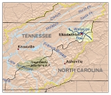
The Doe River is a naturally flowing river in northeast Tennessee
that forms in Carter County
near the North Carolina
line, just south of Roan Mountain State Park
.
, through Roan Mountain State Park and the center of Roan Mountain, Tennessee
, then continues to flow west and is paralleled by U.S. Route 19E. The stream then flows to the east of Fork Mountain; while the Little Doe River
flows by Fork Mountain to the west.
.
spans the Doe River is adjacent to a significant city city park and county government area s.
While allowing for pedestrian
and bicycle
transit over the Doe River, the Elizabethton Covered Bridge is now closed to motor vehicle traffic.
The Doe River spills over a weir dam immediately downstream of the historic covered bridge,and then flows underneath two 1928 concrete arch bridges inside of Elizabethton. The first concrete arch bridge is the Elk Avenue Bridge in downtown Elizabethton, and the second concrete arch bridge downstream of the Elizabethton Covered Bridge is locally known as the Broad Street Bridge. The Broad Street Bridge carries traffic along Tennessee State Route 67
.
The confluence of the Doe River and the Watauga River is approximately fifteen minutes downstream from the Broad Street Bridge.
as Class/Grade I; however there are several brief segments of the Valley Forge-Charity Hill-East Side run that should be approached as Class/Grade II. It takes approximately three hours to float down the Doe River on inner tubes from the Valley Forge put-in to the take-out near the confluence of the Doe River into the Watauga River.
All river tubes and kayaks must portage
around the weir
dam
that is located immediately downstream of the covered bridge in downtown Elizabethton.
There is a Class III/IV section of whitewater referred to as the Doe Gorge that begins at the bridge over the river on Bear Cage Rd. and ends at the take-out at Hampton High School. This sections drops between 100 and 160 feet per mile. The gorge is for advanced paddlers only.
(TVA) regulated flow of the Watauga River
, the water level of the Doe River often fluctuates with changes in rain fall or drought. Another significant difference between the two Carter County rivers is the variation of water temperatures: while the year round water temperature of the Watauga River is approximately 52-53 degrees Fahrenheit, the water temperature of the Doe River will vary along with the ambient air temperature. The Doe River is generally very comfortable for kayaking and river tubing during the summer months.
The Doe River valley is infrequently subject to severe flooding. The Doe River drains from a mountainous region that can be subject to seasonal heavy rains (May-early June) and snow melts, and the Doe River stream course is in many parts quite steep, allowing water levels to rise rapidly along the river banks. The last severe recent flooding of the Doe River occurred overnight from January 7 through January 8, 1998, with the sudden storms bringing down seven inches (178 mm) of rain in twelve hours and causing the deaths of seven people (including Kingsport
rescue worker Carles "Junior" Godsey after his rescue boat overturned in the Doe River flood waters) in the Hampton area. The 1998 Doe River flood created approximately $20 million in Carter County property damages.
Tennessee
Tennessee is a U.S. state located in the Southeastern United States. It has a population of 6,346,105, making it the nation's 17th-largest state by population, and covers , making it the 36th-largest by total land area...
that forms in Carter County
Carter County, Tennessee
Carter County is a county located in the U.S. state of Tennessee. As of 2010, the population was 57,424. Its county seat is Elizabethton.Carter County is part of the Johnson City Metropolitan Statistical Area, which is a component of the Johnson City–Kingsport–Bristol, TN-VA Combined...
near the North Carolina
North Carolina
North Carolina is a state located in the southeastern United States. The state borders South Carolina and Georgia to the south, Tennessee to the west and Virginia to the north. North Carolina contains 100 counties. Its capital is Raleigh, and its largest city is Charlotte...
line, just south of Roan Mountain State Park
Roan Mountain State Park
Roan Mountain State Park is a Tennessee state park in Carter County in Northeast Tennessee along the Tennessee-North Carolina border near the community of Roan Mountain, Tennessee. Situated in the Blue Ridge of the Appalachian Mountains, the park preserves woodlands near 6,285 foot Roan Mountain...
.
Hydrography
The Doe River flows from the northern slopes of Roan MountainRoan Mountain (Roan Highlands)
Roan Mountain is the highpoint of the Roan-Unaka Range of the Southern Appalachian Mountains, located in the Southeastern United States. The mountain is clad in a dense stand of Southern Appalachian spruce-fir forest, and includes the world's largest natural rhododendron garden, and the longest...
, through Roan Mountain State Park and the center of Roan Mountain, Tennessee
Roan Mountain, Tennessee
Roan Mountain is a census-designated place in Carter County, Tennessee, United States. The population was 1,360 at the 2010 census. It is part of the Johnson City Metropolitan Statistical Area, which is a component of the Johnson City–Kingsport–Bristol, TN-VA Combined Statistical Area...
, then continues to flow west and is paralleled by U.S. Route 19E. The stream then flows to the east of Fork Mountain; while the Little Doe River
Little Doe River
The Little Doe River is a river located in Carter County, Tennessee. It forms from the confluence of Simerly Creek and Tiger Creek near the community of Tiger Valley, and runs in a northerly direction alongside U.S. Route 19E until its termination into Doe River just south of the town of Hampton,...
flows by Fork Mountain to the west.
Hampton and Valley Forge
Pushing through a mountain gap just north of Hampton, Tennessee, the volume of the Doe River is increased by the waters flowing from McCathern Spring. Below the confluence of both the Doe River and the Little Doe River at Hampton, the Doe River travels roughly in a northern direction through the Valley Forge community, and is rejoined by U.S. Route 19E outside of ElizabethtonElizabethton, Tennessee
Elizabethton is the county seat of Carter County, Tennessee, United States. Elizabethton is also the historical site both of the first independent American government located west of both the Eastern Continental Divide and the original thirteen British American colonies.Elizabethton is also the...
.
Elizabethton Covered Bridge
Flowing parallel with U.S. Highway 19-E, the Doe River flows underneath two 19-E bridges at the East Side community before heading in a northwest angle toward the Elizabethton downtown business district. The Elizabethton Covered Bridge is located in downtown Elizabethton, the county seat of Carter County. Connecting 3rd Street and Hattie Avenue, the historic 1882 covered bridgeCovered bridge
A covered bridge is a bridge with enclosed sides and a roof, often accommodating only a single lane of traffic. Most covered bridges are wooden; some newer ones are concrete or metal with glass sides...
spans the Doe River is adjacent to a significant city city park and county government area s.
While allowing for pedestrian
Pedestrian
A pedestrian is a person traveling on foot, whether walking or running. In some communities, those traveling using roller skates or skateboards are also considered to be pedestrians. In modern times, the term mostly refers to someone walking on a road or footpath, but this was not the case...
and bicycle
Bicycle
A bicycle, also known as a bike, pushbike or cycle, is a human-powered, pedal-driven, single-track vehicle, having two wheels attached to a frame, one behind the other. A person who rides a bicycle is called a cyclist, or bicyclist....
transit over the Doe River, the Elizabethton Covered Bridge is now closed to motor vehicle traffic.
The Doe River spills over a weir dam immediately downstream of the historic covered bridge,and then flows underneath two 1928 concrete arch bridges inside of Elizabethton. The first concrete arch bridge is the Elk Avenue Bridge in downtown Elizabethton, and the second concrete arch bridge downstream of the Elizabethton Covered Bridge is locally known as the Broad Street Bridge. The Broad Street Bridge carries traffic along Tennessee State Route 67
Tennessee State Route 67
State Route 67 is a state-maintained highway in northeastern Tennessee, including a four-lane divided highway segments in both Washington County and Carter County, and part of a significant two-lane segment passing over the Butler Bridge some above the TVA Watauga Reservoir near Butler in Johnson...
.
The confluence of the Doe River and the Watauga River is approximately fifteen minutes downstream from the Broad Street Bridge.
Whitewater kayaking and river tubing
Most of the Doe River section running between the Valley Forge put-in (LAT 36.310833 LONG -82.193055) and the take-out just before the Elizabethton confluence is classified on the International Scale of River DifficultyInternational Scale of River Difficulty
The International Scale of River Difficulty is a standardized scale used to rate the safety of a stretch of river, or a single rapid. The grade reflects the technical difficulty and skill level required associated with the section of river...
as Class/Grade I; however there are several brief segments of the Valley Forge-Charity Hill-East Side run that should be approached as Class/Grade II. It takes approximately three hours to float down the Doe River on inner tubes from the Valley Forge put-in to the take-out near the confluence of the Doe River into the Watauga River.
All river tubes and kayaks must portage
Portage
Portage or portaging refers to the practice of carrying watercraft or cargo over land to avoid river obstacles, or between two bodies of water. A place where this carrying occurs is also called a portage; a person doing the carrying is called a porter.The English word portage is derived from the...
around the weir
Weir
A weir is a small overflow dam used to alter the flow characteristics of a river or stream. In most cases weirs take the form of a barrier across the river that causes water to pool behind the structure , but allows water to flow over the top...
dam
Dam
A dam is a barrier that impounds water or underground streams. Dams generally serve the primary purpose of retaining water, while other structures such as floodgates or levees are used to manage or prevent water flow into specific land regions. Hydropower and pumped-storage hydroelectricity are...
that is located immediately downstream of the covered bridge in downtown Elizabethton.
There is a Class III/IV section of whitewater referred to as the Doe Gorge that begins at the bridge over the river on Bear Cage Rd. and ends at the take-out at Hampton High School. This sections drops between 100 and 160 feet per mile. The gorge is for advanced paddlers only.
Influence of weather
Unlike the Tennessee Valley AuthorityTennessee Valley Authority
The Tennessee Valley Authority is a federally owned corporation in the United States created by congressional charter in May 1933 to provide navigation, flood control, electricity generation, fertilizer manufacturing, and economic development in the Tennessee Valley, a region particularly affected...
(TVA) regulated flow of the Watauga River
Watauga River
The Watauga River is a large stream of western North Carolina and East Tennessee. It is 60 miles long with its headwaters on the slopes of Grandfather Mountain and Peak Mountain in Watauga County, North Carolina.-Hydrography:...
, the water level of the Doe River often fluctuates with changes in rain fall or drought. Another significant difference between the two Carter County rivers is the variation of water temperatures: while the year round water temperature of the Watauga River is approximately 52-53 degrees Fahrenheit, the water temperature of the Doe River will vary along with the ambient air temperature. The Doe River is generally very comfortable for kayaking and river tubing during the summer months.
The Doe River valley is infrequently subject to severe flooding. The Doe River drains from a mountainous region that can be subject to seasonal heavy rains (May-early June) and snow melts, and the Doe River stream course is in many parts quite steep, allowing water levels to rise rapidly along the river banks. The last severe recent flooding of the Doe River occurred overnight from January 7 through January 8, 1998, with the sudden storms bringing down seven inches (178 mm) of rain in twelve hours and causing the deaths of seven people (including Kingsport
Kingsport, Tennessee
Kingsport is a city located mainly in Sullivan County with some western portions in Hawkins County in the US state of Tennessee. The majority of the city lies in Sullivan County...
rescue worker Carles "Junior" Godsey after his rescue boat overturned in the Doe River flood waters) in the Hampton area. The 1998 Doe River flood created approximately $20 million in Carter County property damages.
| Month | Jan | Feb | Mar | Apr | May | Jun | Jul | Aug | Sep | Oct | Nov | Dec | Annual |
|---|---|---|---|---|---|---|---|---|---|---|---|---|---|
| Avg °F(°C) | |
|
|
|
|
|
|
|
|
|
|
|
|
| Avg high °F(°C) | |
|
|
|
|
|
|
|
|
|
|
|
|
| Avg low °F(°C) | -4.3°C |
-2.9°C |
|
|
|
|
|
|
|
|
|
|
|
| Rain (inches) | |
|
|
|
|
|
|
|
|
|
|
|
|
| Snow (inches) | |
|
|
|
|
|
|
|
|
|
|
|
|