

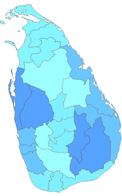
Districts of Sri Lanka
Encyclopedia
In Sri Lanka
, districts are the second-level administrative divisions, and are included in a province
. There are 25 districts organized into 9 provinces. Each district is administered under a District Secretary, who is appointed by the central government. The main tasks of the District Secretariat involve coordinating communications and activities of the central government and Divisional Secretariats. The District Secretariat is also responsible for implementing and monitoring development projects at the district level and assisting lower-level subdivisions in their activities, as well as revenue collection and coordination of elections in the district. A district is divided into a number of Divisional Secretary Divisions (commonly known as DS divisions), which are in turn subdivided into Grama Niladari Divisions. There are 256 DS divisions in the country.
. The kingdom was divided into three provinces; Rajarata, Ruhuna and Malaya Rata. These were further subdivided into smaller units called rata. Over time, the number of provinces increased, but the second-level administrative division continued to be the rata. However, with the country eventually being divided into more than one kingdom and with foreign colonial missions landing and taking parts of the country under their control, this structure began to change. The territory of the Kotte Kingdom was organized into four disavas, which were further subdivided into forty korales. The korales had their own civil and military officials with a small militia. The Jaffna kingdom
appears to have had a similar administrative structure to this with four provinces.
When the Portuguese took over parts of the country
after their arrival in 1505, they maintained more or less the same administrative structure followed by Sri Lankan rulers. During the Dutch rule in the country, the terrain under their control was divided into three administrative divisions. These were subdivided into disavas as in earlier systems. The British
initially continued this system, but following reforms in 1796 to 1802, the country was divided according to ethnic composition. This was abolished by the Colebrook–Cameron
reforms in 1833 and a legislative council
was created, making the island a politically and administratively single unit. Five provinces were created, later expanded into nine, and these were subdivided into twenty-one districts. These districts were administered by officials known as Government Agents or Assistant Government Agents.
In 1955, the district replaced the province as the country's main administrative unit. The Ampara district was created in 1958, followed by the creation of Mullaitivu and Gampaha districts in 1978 through a new constitution
, which also reintroduced the province as the main administrative unit. The last district to be created was Kilinochchi in 1983, and the current constitution (that of 1978) states that the territory of Sri Lanka consists of 25 administrative districts. These districts may be subdivided or amalgamated by a resolution of the Parliament of Sri Lanka
.
Politics of Sri Lanka
Politics of Sri Lanka takes place in a framework of a presidential representative democratic republic, whereby the President of Sri Lanka is both head of state and head of government, and of a multi-party system. Executive power is exercised by the government. Legislative power is vested in both...
, districts are the second-level administrative divisions, and are included in a province
Provinces of Sri Lanka
In Sri Lanka, provinces are the first level administrative division. They were first established by the British rulers of Ceylon in 1833. Over the next century most of the administrative functions were transferred to the districts, the second level administrative division. By the middle of the...
. There are 25 districts organized into 9 provinces. Each district is administered under a District Secretary, who is appointed by the central government. The main tasks of the District Secretariat involve coordinating communications and activities of the central government and Divisional Secretariats. The District Secretariat is also responsible for implementing and monitoring development projects at the district level and assisting lower-level subdivisions in their activities, as well as revenue collection and coordination of elections in the district. A district is divided into a number of Divisional Secretary Divisions (commonly known as DS divisions), which are in turn subdivided into Grama Niladari Divisions. There are 256 DS divisions in the country.
History
The country was first divided into several administrative units during the Anuradhapura KingdomAnuradhapura Kingdom
The Anuradhapura Kingdom , named for its capital city, was the first established kingdom in ancient Sri Lanka. Founded by King Pandukabhaya in 377 BC, the kingdom's authority extended throughout the country, although several independent areas emerged from time to time, which grew more numerous...
. The kingdom was divided into three provinces; Rajarata, Ruhuna and Malaya Rata. These were further subdivided into smaller units called rata. Over time, the number of provinces increased, but the second-level administrative division continued to be the rata. However, with the country eventually being divided into more than one kingdom and with foreign colonial missions landing and taking parts of the country under their control, this structure began to change. The territory of the Kotte Kingdom was organized into four disavas, which were further subdivided into forty korales. The korales had their own civil and military officials with a small militia. The Jaffna kingdom
Jaffna Kingdom
The Jaffna kingdom , also known as Kingdom of Aryacakravarti, of modern northern Sri Lanka was a historic monarchy that came into existence around the town of Jaffna on the Jaffna peninsula after the invasion of Magha, who is said to have been from Kalinga, in India...
appears to have had a similar administrative structure to this with four provinces.
When the Portuguese took over parts of the country
Portuguese period in Ceylon
Portuguese Ceylon was a Portuguese territory in present-day Sri Lanka, representing a period in Sri Lankan history from 1505–1658. The Portuguese first encountered the Ceylonese kingdom of Kotte, with whom they signed a treaty. Portuguese Ceylon was established through the occupation of Kotte and...
after their arrival in 1505, they maintained more or less the same administrative structure followed by Sri Lankan rulers. During the Dutch rule in the country, the terrain under their control was divided into three administrative divisions. These were subdivided into disavas as in earlier systems. The British
British Ceylon
British Ceylon refers to British rule prior to 1948 of the island territory now known as Sri Lanka.-From the Dutch to the British:Before the beginning of the Dutch governance, the island of Ceylon was divided between the Portuguese Empire and the Kingdom of Kandy, who were in the midst of a war for...
initially continued this system, but following reforms in 1796 to 1802, the country was divided according to ethnic composition. This was abolished by the Colebrook–Cameron
Colebrooke-Cameron Commission
The Colebrooke-Cameron Commission was a Royal Commission of Eastern Inquiry sent by the British Colonial Office in 1829 to assess the administration of the island of Ceylon and to make recommendations for administrative, financial, economic, and judicial reform...
reforms in 1833 and a legislative council
Legislative Council
A Legislative Council is the name given to the legislatures, or one of the chambers of the legislature of many nations and colonies.A Member of the Legislative Council is commonly referred to as an MLC.- Unicameral legislatures :...
was created, making the island a politically and administratively single unit. Five provinces were created, later expanded into nine, and these were subdivided into twenty-one districts. These districts were administered by officials known as Government Agents or Assistant Government Agents.
In 1955, the district replaced the province as the country's main administrative unit. The Ampara district was created in 1958, followed by the creation of Mullaitivu and Gampaha districts in 1978 through a new constitution
Constitution of Sri Lanka
The Constitution of the Democratic Socialist Republic of Sri Lanka has been the constitution of the island nation of Sri Lanka since its original promulgation by the National State Assembly on 7 September 1978. It is Sri Lanka's second republican constitution, and its third constitution since the...
, which also reintroduced the province as the main administrative unit. The last district to be created was Kilinochchi in 1983, and the current constitution (that of 1978) states that the territory of Sri Lanka consists of 25 administrative districts. These districts may be subdivided or amalgamated by a resolution of the Parliament of Sri Lanka
Parliament of Sri Lanka
The Parliament of Sri Lanka is the 225-member unicameral legislature of Sri Lanka. The members of Parliament are elected by proportional representation for six-year terms, with universal suffrage. Parliament reserves the power to make all laws...
.
Districts
All population data are from the most recent census of Sri Lanka, in 2001. The districts of Jaffna, Mullaitivu and Kilinochchi were not covered in this census because of security reasons, and Batticaloa, Trincomalee, Vavuniya and Mannar were only partially covered. Therefore, the population statistics for these districts are estimates. These are marked by a * symbol.| Name | Area map | Province | District capital |
Land area | Inland water area |
Total area | Population | Population densityPopulation density has been calculated using the land area rather than the total area. |
|---|---|---|---|---|---|---|---|---|
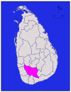
| Ampara Ampara District Ampara district is one of the 25 administrative districts of Sri Lanka. The district is administered by a District Secretariat headed by a District Secretary appointed by the central government of Sri Lanka. The headquarters is located in Ampara town... |
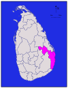 |
Eastern Eastern Province, Sri Lanka The Eastern Province is one of the 9 provinces of Sri Lanka. The provinces have existed since the 19th century but they didn't have any legal status until 1987 when the 13th Amendment to the 1978 Constitution of Sri Lanka established provincial councils. Between 1988 and 2006 the province was... |
Ampara Ampara Ampara is a remote city on the East Coast of Sri Lanka, about 360 km from the capital city of Colombo. It belongs to the Eastern Province of Sri Lanka. It was a part of the domain of Kavantissa and was then known as "Ambaragama", which over the years changed to Ambara to Ampara... |
224222 km² (1,630.1 sq mi) | 18193 km² (74.5 sq mi) | 224415 km² (1,704.6 sq mi) | 12592,997 | 8140 /km2 |
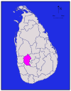
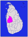
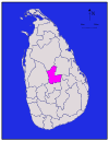
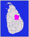
| Anuradhapura Anuradhapura District Anuradhapura is a district in North Central Province, Sri Lanka. Its area is 7,179 km².-Demographics:The population according to 2001 census is 745,693 of which 90.7 % are sinhalese, 8.3 % Sri Lankan Moors, 0.7 % native Sri Lankan tamils and 0.1 % tamils of Indian origin... |
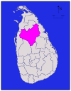 |
North Central North Central Province, Sri Lanka North Central Province is a province of Sri Lanka. Its capital is Anuradhapura. The province is not densely populated with a weak economy, as the land tends to be dry tropical woodlands.-History:... |
Anuradhapura Anuradhapura Anuradhapura, , is one of the ancient capitals of Sri Lanka, famous for its well-preserved ruins of ancient Lankan civilization.The city, now a UNESCO World Heritage Site, lies 205 km north of the current capital Colombo in Sri Lanka's North Central Province, on the banks of the historic... |
256664 km² (2,573 sq mi) | 23515 km² (198.8 sq mi) | 257179 km² (2,771.8 sq mi) | 15745,693 | 5112 /km2 |
| Badulla Badulla District Badulla is a district in Uva Province, Sri Lanka. The entire land area of the Badulla district is 2,861 km² and total population is 837,000. The district is bounded by the districts of Monaragala and Rathnapura on the East & South, by Ampara and Kandy districts on the North and by Nuwara... |
 |
Uva | Badulla Badulla Badulla , is the capital of Uva Province, Sri Lanka. Badulla is located 60 km southeast of Kandy, almost encircled by the Badulu Oya River, about 680 metres above sea level and is surrounded by picturesque hills and mountains, most of which have tea plantations.-Geography:It is located on the... |
182827 km² (1,091.5 sq mi) | 534 km² (13.1 sq mi) | 182861 km² (1,104.6 sq mi) | 17779,983 | 13276 /km2 |
| Batticaloa Batticaloa District Batticaloa district is one of the 25 administrative districts of Sri Lanka. The district is administered by a District Secretariat headed by a District Secretary appointed by the central government of Sri Lanka. The headquarters is located in Batticaloa town... |
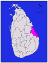 |
Eastern Eastern Province, Sri Lanka The Eastern Province is one of the 9 provinces of Sri Lanka. The provinces have existed since the 19th century but they didn't have any legal status until 1987 when the 13th Amendment to the 1978 Constitution of Sri Lanka established provincial councils. Between 1988 and 2006 the province was... |
Batticaloa Batticaloa Batticaloa is a city in the Eastern province of Sri Lanka. It is the seat of the Eastern University of Sri Lanka. It is on the east coast, south by south east of Trincomalee, and is situated on an island.-Etymology:... |
172610 km² (1,007.7 sq mi) | 22244 km² (94.2 sq mi) | 172854 km² (1,101.9 sq mi) | 9486,447 * | 9186 /km2 |
| Colombo Colombo District Colombo District is the smallest district in Sri Lanka with an area of 642 km². It is located in the Western Province, on the western coast of the island. Sri Lanka’s commercial capital, Colombo and the political capital, Sri Jayewardenepura Kotte are located in this district... |
 |
Western Western Province, Sri Lanka The Western Province is the most densely populated province of Sri Lanka. It is home to the legislative capital Sri Jayawardenapura as well to Colombo, the nation's administrative and business center.-Districts:Basnahira is divided into 3 districts:... |
Colombo Colombo Colombo is the largest city of Sri Lanka. It is located on the west coast of the island and adjacent to Sri Jayawardenapura Kotte, the capital of Sri Lanka. Colombo is often referred to as the capital of the country, since Sri Jayawardenapura Kotte is a satellite city of Colombo... |
1676 km² (261 sq mi) | 423 km² (8.9 sq mi) | 1699 km² (269.9 sq mi) | 252,251,274 | 243330 /km2 |
| Galle Galle District Galle is a district in Southern Province, Sri Lanka.- Geological background :Its area is , in which is water and is land. Galle District bounded on the North by Benthara river, South and West by the Indian Ocean and East by Matara and Ratnapura Districts. Topography of Galle District is very... |
 |
Southern Southern Province, Sri Lanka The Southern Province of Sri Lanka is a small geographic area consisting of the districts of Galle, Matara and Hambantota. The region is economically backward compared to the Western province, where the capital Sri Jayawardenapura-Kotte is situated... |
Galle Galle Galle is a city situated on the southwestern tip of Sri Lanka, 119 km from Colombo. Galle is the capital city of Southern Province of Sri Lanka and it lies in Galle District.... |
71617 km² (624.3 sq mi) | 635 km² (13.5 sq mi) | 71652 km² (637.8 sq mi) | 19990,487 | 20613 /km2 |
| Gampaha Gampaha District - Local Authorities in Gampaha district:Gampaha is the District Capital of Gampaha District and is a principal town around Colombo. It is about 4 km from Miriswatte on the Colombo - Kandy Road.- Urban Councils :* Katunayake-Seeduwa * Ja-ela* Wattala... |
 |
Western Western Province, Sri Lanka The Western Province is the most densely populated province of Sri Lanka. It is home to the legislative capital Sri Jayawardenapura as well to Colombo, the nation's administrative and business center.-Districts:Basnahira is divided into 3 districts:... |
Gampaha Gampaha Gampaha is an urban city in Sri Lanka and is the capital of the Gampaha District in Western Province, north of Colombo. Gampaha District is separated from Colombo mainly by the Kelani River.-Namesake:... |
51341 km² (517.8 sq mi) | 946 km² (17.8 sq mi) | 51387 km² (535.5 sq mi) | 242,063,684 | 231539 /km2 |
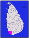
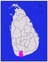
| Hambantota Hambantota District Hambantota District is located on the southeastern coast of Sri Lanka, in the Southern Province. It has an area of 2,593 km² and a very dry climate. The district capital is Hambantota town; the administrative headquarters are located there as well as the center of salt production... |
 |
Southern Southern Province, Sri Lanka The Southern Province of Sri Lanka is a small geographic area consisting of the districts of Galle, Matara and Hambantota. The region is economically backward compared to the Western province, where the capital Sri Jayawardenapura-Kotte is situated... |
Hambantota Hambantota Hambantota is a coastal city in the south of Sri Lanka. It is the capital of the Hambantota District... |
152496 km² (963.7 sq mi) | 13113 km² (43.6 sq mi) | 142609 km² (1,007.3 sq mi) | 11526,414 | 10211 /km2 |
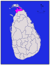
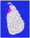
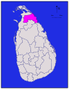
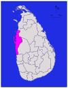
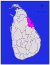
| Jaffna Jaffna District Jaffna district is one of the 25 administrative districts of Sri Lanka. The district is administered by a District Secretariat headed by a District Secretary appointed by the central government of Sri Lanka. The headquarters is located in Jaffna city. Parts of the district were transferred to... |
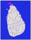 |
Northern Northern Province, Sri Lanka The Northern Province is one of the 9 provinces of Sri Lanka. The provinces have existed since the 19th century but did not have any legal status until 1987 when the 13th Amendment to the 1978 Constitution of Sri Lanka established provincial councils. Between 1988 and 2006 the province was... |
Jaffna Jaffna Jaffna is the capital city of the Northern Province, Sri Lanka. It is the administrative headquarters of the Jaffna district located on a peninsula of the same name. Jaffna is approximately six miles away from Kandarodai which served as a famous emporium in the Jaffna peninsula from classical... |
2929 km² (358.7 sq mi) | 1196 km² (37.1 sq mi) | 21025 km² (395.8 sq mi) | 10490,621 * | 18528 /km2 |
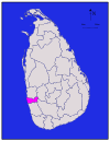
| Kalutara | 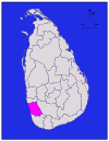 |
Western Western Province, Sri Lanka The Western Province is the most densely populated province of Sri Lanka. It is home to the legislative capital Sri Jayawardenapura as well to Colombo, the nation's administrative and business center.-Districts:Basnahira is divided into 3 districts:... |
Kalutara Kalutara Kalutara is a resort town located approximately 40 km south of Colombo in Sri Lanka.- Overview :Once an important spice-trading center, the city's name is derived from the Kalu Ganga River . In the 11th Century, the town was temporarily made a capital on the orders of a South Indian Prince... |
61576 km² (608.5 sq mi) | 322 km² (8.5 sq mi) | 61598 km² (617 sq mi) | 211,066,239 | 22677 /km2 |
| Kandy Kandy District Kandy District is a district of the Central Province of Sri Lanka. Its area is 1906.3 km². The capital of the district is Kandy.- Demographics :... |
 |
Central | Kandy Kandy Kandy is a city in the center of Sri Lanka. It was the last capital of the ancient kings' era of Sri Lanka. The city lies in the midst of hills in the Kandy plateau, which crosses an area of tropical plantations, mainly tea. Kandy is one of the most scenic cities in Sri Lanka; it is both an... |
121917 km² (740.2 sq mi) | 423 km² (8.9 sq mi) | 101940 km² (749 sq mi) | 221,279,028 | 21667 /km2 |
| Kegalle Kegalle District Kegalle is a district in Sabaragamuwa Province, Sri Lanka. Its area is 1,663 km². It was a former Dissavani of Sri Lanka. Has a population of 785,524 according to census 2001.-Physical Information:... |
 |
Sabaragamuwa | Kegalle Kegalle Kegalle is a town in Sabaragamuwa Province of Sri Lanka. It is located on the Colombo - Kandy road. Its 48 miles/78 km away from Colombo and 24 Miles/40 km away from Kandy. It is the Capital City of the Kegalle District which is one of the two districts belonging to Sabaragamuwa province... |
81685 km² (650.6 sq mi) | 18 km² (3.1 sq mi) | 81693 km² (653.7 sq mi) | 18785,524 | 17466 /km2 |
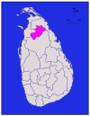
| Kilinochchi Kilinochchi District Kilinochchi district is one of the 25 administrative districts of Sri Lanka. The district is administered by a District Secretariat headed by a District Secretary appointed by the central government of Sri Lanka. The headquarters is located in Kilinochchi town... |
 |
Northern Northern Province, Sri Lanka The Northern Province is one of the 9 provinces of Sri Lanka. The provinces have existed since the 19th century but did not have any legal status until 1987 when the 13th Amendment to the 1978 Constitution of Sri Lanka established provincial councils. Between 1988 and 2006 the province was... |
Kilinochchi Kilinochchi Kilinochchi is a city in the Kilinochchi District, part of the Northern Province of Sri Lanka. Kilinochchi is situated at the A9 road some south-east of Jaffna... |
31205 km² (465.3 sq mi) | 1074 km² (28.6 sq mi) | 31279 km² (493.8 sq mi) | 2127,263 * | 4106 /km2 |
| Kurunegala Kurunegala District Kurunegala is a district in North Western Province, Sri Lanka. Its area is 4,771 km².... |
 |
North Western North Western Province, Sri Lanka North Western Province is a province of Sri Lanka. The districts of Kurunegala and Puttalam formulate Wayamba. Its capital is Kurunegala, which has a population of 28,571. The province is known mainly for its numerous coconut plantations. Other main towns in this province are Chilaw and Puttalam... |
Kurunegala Kurunegala Kurunegala , is the capital of the North Western Province, Sri Lanka, Sri Lanka and the Kurunegala District. Kurunegala was also an ancient royal capital for 50 years, from the end of the 13th century to the start of the 13th century. The town itself is a busy commercial and a transport hub... |
234624 km² (1,785.3 sq mi) | 17192 km² (74.1 sq mi) | 234816 km² (1,859.5 sq mi) | 231,460,215 | 15316 /km2 |
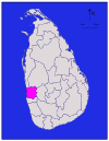
| Mannar Mannar District Mannar district is one of the 25 administrative districts of Sri Lanka. The district is administered by a District Secretariat headed by a District Secretary appointed by the central government of Sri Lanka. The headquarters is located in Mannar, Sri Lanka... |
 |
Northern Northern Province, Sri Lanka The Northern Province is one of the 9 provinces of Sri Lanka. The provinces have existed since the 19th century but did not have any legal status until 1987 when the 13th Amendment to the 1978 Constitution of Sri Lanka established provincial councils. Between 1988 and 2006 the province was... |
Mannar Mannar, Sri Lanka Mannar , formerly spelled Manar, is the capital of Mannar District, Sri Lanka. It is located on Mannar Island.Mannar is known for its baobab trees and for its fort, built by the Portuguese in 1560 and taken by the Dutch in 1658 and rebuilt; its ramparts and bastions are intact, though the interior... |
111880 km² (725.9 sq mi) | 14116 km² (44.8 sq mi) | 131996 km² (770.7 sq mi) | 4151,577 * | 3/km2 (/sq mi) |
| Matale Matale District Matale District is a district in Central Province, Sri Lanka. Its area is 1,987 km².- Demographics :The population according to 2001 census is 441,328. 80.1 % of the population are Sinhalese, 8.7 % Sri Lankan Moors, 5.5 % native Sri Lankan tamils and 5.3 % tamils of... |
 |
Central | Matale Matale Matale is a town in the hill country of Sri Lanka, from Colombo and from Kandy. It is an area steeped in history and village living. The mayor of Matale is Hilmy Careem, as of May, 2006.... |
131952 km² (753.7 sq mi) | 841 km² (15.8 sq mi) | 121993 km² (769.5 sq mi) | 8441,328 | 11226 /km2 |
| Matara Matara District Matara is a district in Southern Province, Sri Lanka. Its area is 1,246 km². It is represented in the Sri Lankan Parliament following the Sri Lankan parliamentary election, 2010 by former Sri Lankan national Cricketer Sanath Jayasuriya who stood for the United People's Freedom Alliance.... |
 |
Southern Southern Province, Sri Lanka The Southern Province of Sri Lanka is a small geographic area consisting of the districts of Galle, Matara and Hambantota. The region is economically backward compared to the Western province, where the capital Sri Jayawardenapura-Kotte is situated... |
Matara Matara, Sri Lanka Matara is a city on the southern coast of Sri Lanka, 160 km from Colombo. It is one of the largest cities in Sri Lanka. It was deeply affected by the Asian tsunami in December 2004.-History:... |
41270 km² (490.3 sq mi) | 213 km² (5 sq mi) | 41283 km² (495.4 sq mi) | 16761,370 | 19600 /km2 |
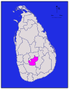
| Moneragala Moneragala District Moneragala is a district in Uva Province of Sri Lanka. It is the largest of the 25 districts of Sri Lanka, with an area of 7,133 km².-Statistics:In 2008 - Source-External links:*... |
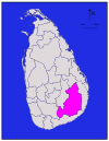 |
Uva | Moneragala Moneragala Moneragala is a city in Sri Lanka. It is located in Moneragala District of Uva Province, Sri Lanka.-References:... |
245508 km² (2,126.7 sq mi) | 15131 km² (50.6 sq mi) | 245639 km² (2,177.2 sq mi) | 7397,375 | 272 /km2 |
| Mullaitivu Mullaitivu District Mullaitivu district is one of the 25 administrative districts of Sri Lanka. The district is administered by a District Secretariat headed by a District Secretary appointed by the central government of Sri Lanka. The headquarters is located in Mullaitivu town... |
 |
Northern Northern Province, Sri Lanka The Northern Province is one of the 9 provinces of Sri Lanka. The provinces have existed since the 19th century but did not have any legal status until 1987 when the 13th Amendment to the 1978 Constitution of Sri Lanka established provincial councils. Between 1988 and 2006 the province was... |
Mullaitivu Mullaitivu Mullaitivu is a small town on the north-eastern coast of Sri Lanka. It is the capital of Mullaitivu District in the Northern Province of Sri Lanka. A largely fishing settlement, the town in the early 20th century grew as an anchoring harbour of the small sailing vessels transporting goods between... |
142415 km² (932.4 sq mi) | 20202 km² (78 sq mi) | 152617 km² (1,010.4 sq mi) | 1121,667 * | 150 /km2 |
| Nuwara Eliya Nuwara Eliya District Nuwara Eliya District is a district in Central Province, Sri Lanka. Its area is 1,228 km². Nuwara Eliya town is a tourist attraction.-Demographics:... |
 |
Central | Nuwara Eliya Nuwara Eliya Nuwara Eliya , meaning "city on the plain " or "city of light", is a town in the central highlands of Sri Lanka with a picturesque landscape and temperate climate. It is located at an altitude of 1,868 m and is considered to be the most important location for Tea production in Sri Lanka... |
91706 km² (658.7 sq mi) | 635 km² (13.5 sq mi) | 91741 km² (672.2 sq mi) | 13703,610 | 16412 /km2 |
| Polonnaruwa Polonnaruwa District Polonnaruwa is a district in North Central Province, Sri Lanka. Its area is 3,403 km².... |
 |
North Central North Central Province, Sri Lanka North Central Province is a province of Sri Lanka. Its capital is Anuradhapura. The province is not densely populated with a weak economy, as the land tends to be dry tropical woodlands.-History:... |
Polonnaruwa Polonnaruwa The second most ancient of Sri Lanka's kingdoms, was first declared the capital city by King Vijayabahu I, who defeated the Chola invaders in 1070 AD to reunite the country once more under a local leader.-History:While Vijayabahu's victory and shifting of Kingdoms to the more strategic Polonnaruwa... |
203077 km² (1,188 sq mi) | 21216 km² (83.4 sq mi) | 213293 km² (1,271.4 sq mi) | 6358,984 | 6117 /km2 |
| Puttalam Puttalam District Puttalam is a district situated near to the west coast of Sri Lanka. It has an area of . Along with the Kurunegala District, it formulates the North Western Province of Sri Lanka. The district capital is Puttalam, which borders the Kala Oya and Modaragam Aru in the north, Anuradhapura District and... |
 |
North Western North Western Province, Sri Lanka North Western Province is a province of Sri Lanka. The districts of Kurunegala and Puttalam formulate Wayamba. Its capital is Kurunegala, which has a population of 28,571. The province is known mainly for its numerous coconut plantations. Other main towns in this province are Chilaw and Puttalam... |
Puttalam Puttalam Puttalam is the capital city of the Puttalam District in North Western Province, Sri Lanka.-History:The history of this dry zone dates back to the arrival of Prince Vijaya, nearly 2500 years ago, when his vessel washed ashore. The name "Puttalam" may be a modification of the Tamil word Uppuththalam... |
192882 km² (1,112.7 sq mi) | 16190 km² (73.4 sq mi) | 193072 km² (1,186.1 sq mi) | 14709,677 | 12246 /km2 |
| Ratnapura Ratnapura District Ratnapura is a district of Sri Lanka in the province of Sabaragamuwa.The gem-mining centre of Sri Lanka is also a major crossroad between southern plains and the hill country to the east. A bustling market city servicing most of the surrounding towns. Many of the prominent gem dealers in Sri Lanka... |
 |
Sabaragamuwa | Ratnapura Ratnapura - Floods :The town of Ratnapura is situated in the flooding plain of the river Kalu. The town experiences regular floods usually in the month of May. There is no large dam across the Kalu, so this leaves the city at the mercy of nature's forces every year. Several proposals have been made to reduce... |
213236 km² (1,249.4 sq mi) | 739 km² (15.1 sq mi) | 203275 km² (1,264.5 sq mi) | 201,015,807 | 14314 /km2 |
| Trincomalee Trincomalee District Trincomalee district is one of the 25 administrative districts of Sri Lanka. The district is administered by a District Secretariat headed by a District Secretary appointed by the central government of Sri Lanka... |
 |
Eastern Eastern Province, Sri Lanka The Eastern Province is one of the 9 provinces of Sri Lanka. The provinces have existed since the 19th century but they didn't have any legal status until 1987 when the 13th Amendment to the 1978 Constitution of Sri Lanka established provincial councils. Between 1988 and 2006 the province was... |
Trincomalee Trincomalee Trincomalee is a port city in Eastern Province, Sri Lanka and lies on the east coast of the island, about 113 miles south of Jaffna. It has a population of approximately 100,000 . The city is built on a peninsula, which divides the inner and outer harbours. Overlooking the Kottiyar Bay,... |
162529 km² (976.5 sq mi) | 19198 km² (76.4 sq mi) | 162727 km² (1,052.9 sq mi) | 5340,158 * | 7/km2 (/sq mi) |
| Vavuniya Vavuniya District Vavuniya district is one of the 25 administrative districts of Sri Lanka. The district is administered by a District Secretariat headed by a District Secretary appointed by the central government of Sri Lanka. The headquarters is located in Vavuniya town... |
 |
Northern Northern Province, Sri Lanka The Northern Province is one of the 9 provinces of Sri Lanka. The provinces have existed since the 19th century but did not have any legal status until 1987 when the 13th Amendment to the 1978 Constitution of Sri Lanka established provincial councils. Between 1988 and 2006 the province was... |
Vavuniya Vavuniya Vavuniya is a town in northern Sri Lanka. This town is situated in the Northern Province. Vavuniya was often referred to as the gateway to Vanni.... |
101861 km² (718.5 sq mi) | 12106 km² (40.9 sq mi) | 111967 km² (759.5 sq mi) | 3149,835 * | 3/km2 (/sq mi) |
| Total | 62705 km² (24,210.5 sq mi) | 2905 km² (1,121.6 sq mi) | km2 | 18,797,257 | /km2 |