
Badulla District
Encyclopedia
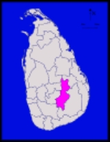
Badulla is a district
in Uva Province
, Sri Lanka
. The entire land area of the Badulla district is 2,861 km² and total population is 837,000. The district is bounded by the districts of Monaragala and Rathnapura on the East & South, by Ampara
and Kandy
districts on the North and by Nuwara Eliya
and Rathnapura on the West. Mainly the economy of the district is based on agricultural farming
and livestock
.
Badulla District is an agricultural district where tea, vegetable
and paddy
are cultivated. Mainly the district is divided in to two portions as Upper region and Lower region according to climatic and geographical characteristics. Upper division of the district is famous for tea plantation
and vegetable cultivation while lower division is famous for paddy cultivation. ref>Uva
Population by Religion
Budhists 612944
Hindus 170673
Muslims 81020
Roman Catholics 16396
Other Christinas 6187
Population by Religion %
Budhists 69.08
Hindus 19.24
Muslims 9.13
Roman Catholics 1.85
Other Christians 0.70
Districts of Sri Lanka
In Sri Lanka, districts are the second-level administrative divisions, and are included in a province. There are 25 districts organized into 9 provinces. Each district is administered under a District Secretary, who is appointed by the central government...
in Uva Province
Uva Province
Uva is Sri Lanka's second least populated province, with 1,187,335 people, created in 1896. It consists of two districts: Badulla බදුල්ල பதுளை and Moneragala මොනරාගල மொனராகல. The provincial capital is Badulla. Uva is bordered by Eastern, Southern and Central provinces...
, Sri Lanka
Sri Lanka
Sri Lanka, officially the Democratic Socialist Republic of Sri Lanka is a country off the southern coast of the Indian subcontinent. Known until 1972 as Ceylon , Sri Lanka is an island surrounded by the Indian Ocean, the Gulf of Mannar and the Palk Strait, and lies in the vicinity of India and the...
. The entire land area of the Badulla district is 2,861 km² and total population is 837,000. The district is bounded by the districts of Monaragala and Rathnapura on the East & South, by Ampara
Ampara
Ampara is a remote city on the East Coast of Sri Lanka, about 360 km from the capital city of Colombo. It belongs to the Eastern Province of Sri Lanka. It was a part of the domain of Kavantissa and was then known as "Ambaragama", which over the years changed to Ambara to Ampara...
and Kandy
Kandy
Kandy is a city in the center of Sri Lanka. It was the last capital of the ancient kings' era of Sri Lanka. The city lies in the midst of hills in the Kandy plateau, which crosses an area of tropical plantations, mainly tea. Kandy is one of the most scenic cities in Sri Lanka; it is both an...
districts on the North and by Nuwara Eliya
Nuwara Eliya
Nuwara Eliya , meaning "city on the plain " or "city of light", is a town in the central highlands of Sri Lanka with a picturesque landscape and temperate climate. It is located at an altitude of 1,868 m and is considered to be the most important location for Tea production in Sri Lanka...
and Rathnapura on the West. Mainly the economy of the district is based on agricultural farming
Agriculture
Agriculture is the cultivation of animals, plants, fungi and other life forms for food, fiber, and other products used to sustain life. Agriculture was the key implement in the rise of sedentary human civilization, whereby farming of domesticated species created food surpluses that nurtured the...
and livestock
Livestock
Livestock refers to one or more domesticated animals raised in an agricultural setting to produce commodities such as food, fiber and labor. The term "livestock" as used in this article does not include poultry or farmed fish; however the inclusion of these, especially poultry, within the meaning...
.
Badulla District is an agricultural district where tea, vegetable
Vegetable
The noun vegetable usually means an edible plant or part of a plant other than a sweet fruit or seed. This typically means the leaf, stem, or root of a plant....
and paddy
Paddy field
A paddy field is a flooded parcel of arable land used for growing rice and other semiaquatic crops. Paddy fields are a typical feature of rice farming in east, south and southeast Asia. Paddies can be built into steep hillsides as terraces and adjacent to depressed or steeply sloped features such...
are cultivated. Mainly the district is divided in to two portions as Upper region and Lower region according to climatic and geographical characteristics. Upper division of the district is famous for tea plantation
Plantation
A plantation is a long artificially established forest, farm or estate, where crops are grown for sale, often in distant markets rather than for local on-site consumption...
and vegetable cultivation while lower division is famous for paddy cultivation. ref>Uva
Education
Bandarawela Central College, Dharmadutha College, UVA College, Badulla Central College, Vishaka Girls High School, Viharamahadevi Girls School, Passara National College, Passara Tamil National College, Sri Ramakrishna College, Al Adhan Maha Vidyalaya and Saraswathy Central College are situated in this district.Electorate Divisions in Badulla District
- BadullaBadullaBadulla , is the capital of Uva Province, Sri Lanka. Badulla is located 60 km southeast of Kandy, almost encircled by the Badulu Oya River, about 680 metres above sea level and is surrounded by picturesque hills and mountains, most of which have tea plantations.-Geography:It is located on the...
- BandarawelaBandarawelaBandarawela is the second largest city in Badulla District which is 28 km away from Badulla. Due to higher altitude, Bandarawela has a mild weather condition throughout the year hence, it is popular among the citizens to spend the vacations with their family members...
- Hali-Ela
- HaputaleHaputaleHaputale is a town in Badulla District, Sri Lanka. The elevation is 1431 m above the sea level. The area has a rich bio-diversity dense with numerous varieties of flora and fauna. The town has a cooler climate than its surroundings, due to its elevation. The Haputale pass allows views across the...
- MahiyanganaMahiyanganaMahiyangana is a town in Badulla District, Uva Province of Sri Lanka. Some orthodox Sri Lankan Buddhists believe that Lord Gautam Buddha himself traveled from India to visit Sri Lanka and arrived at Mahiyangana to stop a war between the race of Yakshas and the race of Nagas...
ya - Passara
- Uva-Paranagama
- WelimadaWelimada-Administration:The Welimada city is now administered by the Welimada Divisional Council.Notable government institutions include:* Divisional Secretariat* Police Station* Government Hospital-Places of interest:*Divurumwela Old Temple*Sthripura Cave...
- Wiyaluwa
Pradeshiya Sabas (Divisional Areas)
- Badulla
- Mahiyanganaya
- Rideemaliyadda
- Hali-Ela
- Ella
- Bandarawela
- Haputale
- Haldummulla
- Welimada
- Uva-Paranagama
- Kandaketiya
- Meegahakivula
- Soranathota
- Passara
- Lunugala
Demography
(2010 estimates 887220)Population by Religion
Budhists 612944
Hindus 170673
Muslims 81020
Roman Catholics 16396
Other Christinas 6187
Population by Religion %
Budhists 69.08
Hindus 19.24
Muslims 9.13
Roman Catholics 1.85
Other Christians 0.70
Important Locations in Badulla District
- MahiyanganaMahiyanganaMahiyangana is a town in Badulla District, Uva Province of Sri Lanka. Some orthodox Sri Lankan Buddhists believe that Lord Gautam Buddha himself traveled from India to visit Sri Lanka and arrived at Mahiyangana to stop a war between the race of Yakshas and the race of Nagas...
Raja Maha Viharaya - Mauthiyangana Raja Maha Viharaya, BadullaBadullaBadulla , is the capital of Uva Province, Sri Lanka. Badulla is located 60 km southeast of Kandy, almost encircled by the Badulu Oya River, about 680 metres above sea level and is surrounded by picturesque hills and mountains, most of which have tea plantations.-Geography:It is located on the...
- Army Garrison Town, DiyatalawaDiyatalawaDiyatalawa is a garrison town in the central highlands of Sri Lanka, in the Badulla District of Uva Province. It is at an altitude of and has become a popular destination for local holiday makers...
- NamunukulaNamunukulaNamunukula is the name of a mountain range in Sri Lanka's province of Uva. Its main peak is 6600 feet high. The name means "Nine Peaks". It also the name of a town near it which is sometimes called Namunukula Town .-Further reading:...
Mountain Range - Lipton's Seat and Adisham BunglowAdisham HallAdisham Hall, or Adisham Bungalow is a country house near Haputale, in the Badulla District, Sri Lanka. At present it houses the Adisham Monastery a congregation of St. Sylvester....
in HaputaleHaputaleHaputale is a town in Badulla District, Sri Lanka. The elevation is 1431 m above the sea level. The area has a rich bio-diversity dense with numerous varieties of flora and fauna. The town has a cooler climate than its surroundings, due to its elevation. The Haputale pass allows views across the... - Railway bridge and Railway line in Demodara
- BabarakandaBambarakanda FallsBambarakanda Falls is the tallest waterfall in Sri Lanka. With a height of , it ranks as the 299th highest waterfall in the world. Situated in Kalupahana in the Badulla District, this waterfall is directly visible from the A4 Highway. The waterfall was formed by Kuda Oya, which is a branch of the...
, Diyaluma and Ravana Ella Waterfalls - Bogoda Wooden BridgeBogoda Wooden BridgeBogoda wooden bridge was built in the 16th century during the period of Dambadeniya era. This is said to be the oldest surviving wooden bridge in the world. The bridge is situated at 13 km south of Badulla city, Sri Lanka. All parts of this bridge was constructed by woods using wooden nails as...
- Indigenous Vedda people, DambanaDambanaDambana is a village within the Badulla District in Sri Lanka. It is closest to the town of Mahiyangana. It is known as the refuge of the indigenous Vedda people as well as their moribund Vedda language. It is well known for its eco-tourism projects. In 2010 it had population close 1000 individuals...
Maps
See also
- History of Uva ProvinceHistory of Uva ProvinceSri Lanka has divided into nine districts and Uva Province distinct place among them. The natural beauty and the proud history of the province are the main reasons for it.- Name :...
- Health Care of Uva Province - Provincial General Hospital - Badulla