
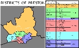
Districts of Preston
Encyclopedia
Preston
is a city
of Lancashire
, England. The districts of Preston vary in size and shape, many of which reflect the districts developed from former villages and boroughs which now lie within the boundaries of the city of Preston. Districts of Preston have little administrative purpose: for local elections voters in each return either two, or three, councillors to Town Hall. For the purposes of national General elections, the parliamentary constituencies representing the city use the electoral districts as "building bricks"
, which are used in the creation of "Area Forums", local consultative bodies organised by city council; and also the composition of parliamentary constituencies.
Electors in each ward return two, or three, electors to Town Hall in elections, results of which can be found at Preston local elections
.
Since 2010, the City of Preston has been covered by three parliamentary constituencies, Preston
, Wyre and Preston North
and Fylde
. Those wards formerly within the Ribble Valley
constituency, on the whole, now form the southern flank of the newly created constituency of Wyre and Preston North.
The wards are used to build electoral divisions for elections to Lancashire County Council
.
The wards of Preston Rural North
, Preston Rural East
and Lea
are parished: they contain parish
councils with their own structure and elected councillors. All the other wards lie in an unparished area
and are governed directly by Preston City Council.
City of Preston, Lancashire
The City of Preston is a city and non-metropolitan district in Lancashire, England. It is located on the north bank of the River Ribble, and was granted city status in 2002, becoming England's 50th city in the 50th year of Queen Elizabeth II's reign...
is a city
City
A city is a relatively large and permanent settlement. Although there is no agreement on how a city is distinguished from a town within general English language meanings, many cities have a particular administrative, legal, or historical status based on local law.For example, in the U.S...
of Lancashire
Lancashire
Lancashire is a non-metropolitan county of historic origin in the North West of England. It takes its name from the city of Lancaster, and is sometimes known as the County of Lancaster. Although Lancaster is still considered to be the county town, Lancashire County Council is based in Preston...
, England. The districts of Preston vary in size and shape, many of which reflect the districts developed from former villages and boroughs which now lie within the boundaries of the city of Preston. Districts of Preston have little administrative purpose: for local elections voters in each return either two, or three, councillors to Town Hall. For the purposes of national General elections, the parliamentary constituencies representing the city use the electoral districts as "building bricks"
Present day divisions
The City of Preston is divided into 22 wardsWards of the United Kingdom
A ward in the United Kingdom is an electoral district at sub-national level represented by one or more councillors. It is the primary unit of British administrative and electoral geography .-England:...
, which are used in the creation of "Area Forums", local consultative bodies organised by city council; and also the composition of parliamentary constituencies.
Electors in each ward return two, or three, electors to Town Hall in elections, results of which can be found at Preston local elections
Preston local elections
One third of Preston City Council in Lancashire, England is elected each year, followed by one year without election.-Political control:Since the first election to the council in 1973 political control of the council has been held by the following parties:...
.
Since 2010, the City of Preston has been covered by three parliamentary constituencies, Preston
Preston (UK Parliament constituency)
Preston is a borough constituency represented in the House of Commons of the Parliament of the United Kingdom. It elects one Member of Parliament by the first past the post system of election.-Boundaries:...
, Wyre and Preston North
Wyre and Preston North (UK Parliament constituency)
Wyre and Preston North is a county constituency represented in the House of Commons of the Parliament of the United Kingdom. Created in the most recent fifth periodic review of constituencies by the Boundary Commission for England, it elects one Member of Parliament by the first past the post...
and Fylde
Fylde (UK Parliament constituency)
Fylde is a county constituency represented in the House of Commons of the Parliament of the United Kingdom. It elects one Member of Parliament by the first past the post system of election.-History:...
. Those wards formerly within the Ribble Valley
Ribble Valley (UK Parliament constituency)
Ribble Valley is a county constituency represented in the House of Commons of the Parliament of the United Kingdom. It elects one Member of Parliament by the first past the post system of election....
constituency, on the whole, now form the southern flank of the newly created constituency of Wyre and Preston North.
The wards are used to build electoral divisions for elections to Lancashire County Council
Lancashire County Council
Lancashire County Council is the upper-tier local authority for the non-metropolitan county of Lancashire, England. It currently consists of 84 councillors, and is controlled by the Conservative Party, who won control of the council in the local council elections in June 2009, ending 28 years of...
.
| Map | County Council Lancashire County Council Lancashire County Council is the upper-tier local authority for the non-metropolitan county of Lancashire, England. It currently consists of 84 councillors, and is controlled by the Conservative Party, who won control of the council in the local council elections in June 2009, ending 28 years of... division |
Ward | Area forum |
Parish Civil parish In England, a civil parish is a territorial designation and, where they are found, the lowest tier of local government below districts and counties... es |
Other places | Parliamentary constituency (from 2010) |
|---|---|---|---|---|---|---|
| Preston Rural |
1. Preston Rural North Preston Rural North Preston Rural North is an electoral ward in the City of Preston, Lancashire, England. The ward is the largest by area in the city, containing the smaller and smallest villages from the northern areas of Preston, from Woodplumpton bordering the M55 motorway junction at Broughton, to Beacon Fell at... |
Rural | Barton Barton, Preston Barton is a linear village and civil parish in the City of Preston, Lancashire, England. The parish had a population of 1,096 according to the 2001 census.-Geography:The village is about north of Preston. The parish is bound by the A6 road to the west... |
Newsham | Wyre and Preston North Wyre and Preston North (UK Parliament constituency) Wyre and Preston North is a county constituency represented in the House of Commons of the Parliament of the United Kingdom. Created in the most recent fifth periodic review of constituencies by the Boundary Commission for England, it elects one Member of Parliament by the first past the post... |
|
| Goosnargh Goosnargh Goosnargh is a village and civil parish on the north side of Preston, Lancashire, England. The village lies between Broughton and Longridge, and mostly lies in the civil parish of Whittingham, although the ancient centre lies in the civil parish of Goosnargh... |
Beacon Fell Beacon Fell Country Park Beacon Fell is a fell in the civil parish of Goosnargh in Lancashire, England. It has been a Country Park since 1970. It falls within the Forest of Bowland Area of Outstanding Natural Beauty although it is separated from the other hills in the Forest... , Inglewhite Inglewhite Inglewhite is a small village in the parish of Goosnargh in Lancashire, England. It lies at the intersection of the roads from Longridge to Garstang and from Broughton to Beacon Fell.-Etymology:... , Whitechapel Whitechapel, Lancashire Whitechapel is a tiny hamlet in the civil parish of Goosnargh in Lancashire, England. It lies on the border of the Forest of Bowland near the foot of Beacon Fell, and close to the neighbouring village of Inglewhite. Its name is marked as White Chapel on some maps.The area was known as "Threlfall"... |
|||||
| Whittingham Whittingham, Lancashire Whittingham is a civil parish in the City of Preston, Lancashire, England. The parish measures east-to-west, from the outskirts of Longridge to the outskirts of Broughton, but only 1 mile north-to-south. Its population was 2,189 in 2001... |
Goosnargh Goosnargh Goosnargh is a village and civil parish on the north side of Preston, Lancashire, England. The village lies between Broughton and Longridge, and mostly lies in the civil parish of Whittingham, although the ancient centre lies in the civil parish of Goosnargh... , Cumeragh Village |
|||||
| Woodplumpton Woodplumpton Woodplumpton is a village and civil parish in the City of Preston, Lancashire, England, located north of Preston.-Geography:It is part of the Fylde, a flat area of land between the Forest of Bowland and the Lancashire coast.-Community:... |
Catforth Catforth Catforth is a village in the English civil parish of Woodplumpton, Lancashire. There is a village hall and the last remaining of Catforth's pubs, The Running Pump, is situated on Catforth Road, which is the village's main road. There is a Roman Catholic church and a primary school.... , Eaves Eaves, Lancashire Eaves is a village in the English county of Lancashire, located six miles north of Preston. It is part of the Fylde, a flat area of land between the Forest of Bowland and the Lancashire coast. The village contains a school and a pub , the oldest in the Fylde.Eaves is in the parish of Woodplumpton.... , Higher Bartle, Nog Tow |
|||||
| 2. Preston Rural East Preston Rural East Preston Rural East is an electoral ward in the City of Preston, Lancashire, England. The ward is in the eastern and northeastern part of the city near the M55 motorway moving out towards Sherwood and Grimsargh.-Parishes:... |
Broughton Broughton, Lancashire Broughton is a village and civil parish in the City of Preston, Lancashire, England, about north of Preston city centre. According to the 2001 census it had a population of 1,735... |
Fernyhalgh | ||||
| Grimsargh Grimsargh Grimsargh is a village and civil parish in the City of Preston, Lancashire, England. According to the 2001 census the parish had a population of 2,164. The parish is part of the electoral ward of Preston Rural East.-Geography:... |
Elston | |||||
| Haighton Haighton Haighton is a civil parish in the City of Preston, Lancashire, England. It is a rural area north east of the urban city of Preston, beyond Fulwood and Brookfield.-Geography:Haighton also contains the hamlets of Haighton Green and Haighton Top... |
Cow Hill, Haighton Green, Haighton Top | |||||
| Preston North |
3. Cadley Cadley, Lancashire Cadley is a largely residential suburban area of Preston, Lancashire and an electoral ward. It is nowadays usually considered to be a district of the larger suburb of Fulwood , but was historically separate as evidenced, for instance, in the name of Fulwood and Cadley County Primary School.Cadley... |
North (Fulwood Fulwood, Lancashire Fulwood is an unparished area of the City of Preston, Lancashire, England, about north of the city centre. It had a population of 33,171 in 2001.- Economy and society :Fulwood remains a distinctive division of Preston... ) |
unparished area Unparished area In England, an unparished area is an area that is not covered by a civil parish. Most urbanised districts of England are either entirely or partly unparished. Many towns and some cities in otherwise rural districts are also unparished areas and therefore no longer have a town council or city... (Preston) |
Nooklands | ||
| 4. Greyfriars Greyfriars, Preston Greyfriars is a largely residential suburban area of Preston, Lancashire and an electoral ward. It is nowadays usually considered to be a district of the larger suburb of Fulwood , but was historically separate as evidenced, for instance, in the name of the private home from which the name is... |
||||||
| Preston North East |
5. Garrison | Fulwood Row, Ladyewell | ||||
| 6. Sharoe Green Sharoe Green Sharoe Green is a largely residential suburban area of Preston, Lancashire, England and an electoral ward. It is nowadays usually considered to be a district of the larger suburb of Fulwood... |
Sherwood | |||||
| Preston Central North |
7. College | |||||
| 8. Deepdale Deepdale, Preston Deepdale is an electoral ward in Preston, Lancashire, England. The ward is home to the Deepdale football stadium of Preston North End. The ward is a predominately urban area of terraced housing, notable for one of the largest Muslim populations in the city.... |
East | Holme Slack | Preston Preston (UK Parliament constituency) Preston is a borough constituency represented in the House of Commons of the Parliament of the United Kingdom. It elects one Member of Parliament by the first past the post system of election.-Boundaries:... |
|||
| 9. Moor Park Moor Park, Preston Moor Park is a large park to the north of the city centre of Preston, Lancashire, England. Moor Park is also the name of the electoral ward covering the park and the surrounding area... |
Central | |||||
| Preston Central South |
10. St George's St George's, Preston St George’s is an electoral ward in Preston, Lancashire, England. The ward is adjacent to the larger Deepdale to the east and is considered to be more an area within Deepdale than a distinct community of its own... |
Adelphi Plungington Plungington is an urban district of Preston, England, to the northwest of the city centre. It is in an area now largely occupied by students attending the University of Central Lancashire. Historically, it was an area of working class terraced housing dating from the late 1880s, most of which have... |
||||
| 11. Tulketh Tulketh Tulketh is an electoral ward in Preston, Lancashire. The ward is named for the former Tulketh Mill, the building of which remains in the division off the A5085 Blackpool Road.... |
Lane Ends, Maudlands | |||||
| 12. University | Adelphi Plungington Plungington is an urban district of Preston, England, to the northwest of the city centre. It is in an area now largely occupied by students attending the University of Central Lancashire. Historically, it was an area of working class terraced housing dating from the late 1880s, most of which have... , Maudlands |
|||||
| Preston City |
13. Riversway Riversway Riversway is an electoral ward in Preston, Lancashire, England. The ward is named for its location close to the River Ribble, and the historical links to the former Port of Preston... |
Broadgate, Christ Church | ||||
| 14. Town Centre Avenham Avenham and Frenchwood are the central communities which make up the Town Centre ward, of Preston City Council, in Lancashire, England. The name of the ward was chosen by the Boundary Committee for England prior to Preston being awarded city status.... |
Avenham Avenham Avenham and Frenchwood are the central communities which make up the Town Centre ward, of Preston City Council, in Lancashire, England. The name of the ward was chosen by the Boundary Committee for England prior to Preston being awarded city status.... , Frenchwood, Winckley Square Winckley Square Winckley Square is situated near the centre of Preston, Lancashire, England, at the west end of Avenham.The square was first established in 1801, around Town End Field owned by Thomas Winckley, as an exclusive residential area for the town's gentry. It is now occupied mostly by insurance, legal and... |
|||||
| Preston West |
15. Ingol Ingol Ingol is an electoral ward and suburb of Preston, Lancashire, England. The ward also includes the suburb of Tanterton. With a golf course within its boundaries and continued new housing development, the area is suburban in its northern and central areas with a more significant low income housing... |
West | Tanterton | |||
| 16. Lea Lea, Lancashire Lea and Cottam are villages in the City of Preston, Lancashire, England. Together they form the civil parish of Lea, which has a population of 5,962.-Geography:... |
Lea Lea, Lancashire Lea and Cottam are villages in the City of Preston, Lancashire, England. Together they form the civil parish of Lea, which has a population of 5,962.-Geography:... |
Cottam, Lea Town | Fylde Fylde (UK Parliament constituency) Fylde is a county constituency represented in the House of Commons of the Parliament of the United Kingdom. It elects one Member of Parliament by the first past the post system of election.-History:... |
|||
| Preston North West |
17. Ashton Ashton-on-Ribble Ashton-on-Ribble is a suburb of Preston, Lancashire, England.The terms Ashton-on-Ribble and Ashton are often used synonymously, although Ashton is a specific electoral ward whilst Ashton-on-Ribble is a term applied more generally to much of the west of Preston... |
unparished area (Preston) |
Preston Preston (UK Parliament constituency) Preston is a borough constituency represented in the House of Commons of the Parliament of the United Kingdom. It elects one Member of Parliament by the first past the post system of election.-Boundaries:... |
|||
| 18. Larches Larches, Preston Larches is one of the districts of Preston, Lancashire, England. The area, north-west of Preston city centre, is a mix of social and private housing, although both components of the ward – Larches, and Savick – are largely post-war council estates... |
Savick | |||||
| Preston South East |
19. Fishwick | East | Farringdon Park | |||
| 20. St Matthew's St Matthew's, Preston St Matthew’s is an electoral ward in Preston, Lancashire, England. The ward is adjacent to the larger Ribbleton to the east but is considered to be an area with a distinct community of its own.... |
||||||
| Preston East |
21. Brookfield Brookfield, Lancashire Brookfield is a suburb and electoral ward of the city of Preston, in Lancashire, England. It is located north-east of the city centre, between Fulwood and Ribbleton. As of the 2001 census the ward had a population of 7,625. , the area is represented on the city council by three Labour councillors... |
|||||
| 22. Ribbleton Ribbleton Ribbleton is a suburb and ward of the city of Preston, Lancashire, England. It is located to the east of the city centre, between the A59 New Hall Lane and the B6243 Longridge Road. The M6 motorway also runs through the area... |
Farringdon Park, Grange, Red Scar, Ribbleton Hall |
The wards of Preston Rural North
Preston Rural North
Preston Rural North is an electoral ward in the City of Preston, Lancashire, England. The ward is the largest by area in the city, containing the smaller and smallest villages from the northern areas of Preston, from Woodplumpton bordering the M55 motorway junction at Broughton, to Beacon Fell at...
, Preston Rural East
Preston Rural East
Preston Rural East is an electoral ward in the City of Preston, Lancashire, England. The ward is in the eastern and northeastern part of the city near the M55 motorway moving out towards Sherwood and Grimsargh.-Parishes:...
and Lea
Lea, Lancashire
Lea and Cottam are villages in the City of Preston, Lancashire, England. Together they form the civil parish of Lea, which has a population of 5,962.-Geography:...
are parished: they contain parish
Civil parish
In England, a civil parish is a territorial designation and, where they are found, the lowest tier of local government below districts and counties...
councils with their own structure and elected councillors. All the other wards lie in an unparished area
Unparished area
In England, an unparished area is an area that is not covered by a civil parish. Most urbanised districts of England are either entirely or partly unparished. Many towns and some cities in otherwise rural districts are also unparished areas and therefore no longer have a town council or city...
and are governed directly by Preston City Council.
Comparison of areas called "Preston"
The name "Preston" is associated with a number of different areas that are related to the city:| Name | Preston | City of Preston City of Preston, Lancashire The City of Preston is a city and non-metropolitan district in Lancashire, England. It is located on the north bank of the River Ribble, and was granted city status in 2002, becoming England's 50th city in the 50th year of Queen Elizabeth II's reign... |
Preston (sub-division of Preston Urban Area) | Preston Urban Area | PRESTON | PR postcode area also known as Preston postcode area |
|---|---|---|---|---|---|---|
| Map | shown within the City of Preston |
shown with the parishes of the City of Preston |
shown within Central Lancashire Central Lancashire Central Lancashire is a designated new town in England. The designated area covers the towns of Preston, Leyland and Chorley... |
shown within the PR postcode area |
||
| Type | unparished area Unparished area In England, an unparished area is an area that is not covered by a civil parish. Most urbanised districts of England are either entirely or partly unparished. Many towns and some cities in otherwise rural districts are also unparished areas and therefore no longer have a town council or city... |
local government district | subdivision of an ONS Office for National Statistics The Office for National Statistics is the executive office of the UK Statistics Authority, a non-ministerial department which reports directly to the Parliament of the United Kingdom.- Overview :... urban area |
ONS Office for National Statistics The Office for National Statistics is the executive office of the UK Statistics Authority, a non-ministerial department which reports directly to the Parliament of the United Kingdom.- Overview :... urban area |
post town Post town A post town is a required part of all postal addresses in the United Kingdom, and a basic unit of the postal delivery system. Including the correct post town in the address increases the chances of a letter or parcel being delivered on time. Post towns are usually based upon the location of... |
postcode area |
| Population (2001) | 112,019 | 129,633 | 184,836 | 264,601 | ||
| Extent | Preston city centre, Fulwood Fulwood, Lancashire Fulwood is an unparished area of the City of Preston, Lancashire, England, about north of the city centre. It had a population of 33,171 in 2001.- Economy and society :Fulwood remains a distinctive division of Preston... , Ribbleton Ribbleton Ribbleton is a suburb and ward of the city of Preston, Lancashire, England. It is located to the east of the city centre, between the A59 New Hall Lane and the B6243 Longridge Road. The M6 motorway also runs through the area... , Ashton-on-Ribble Ashton-on-Ribble Ashton-on-Ribble is a suburb of Preston, Lancashire, England.The terms Ashton-on-Ribble and Ashton are often used synonymously, although Ashton is a specific electoral ward whilst Ashton-on-Ribble is a term applied more generally to much of the west of Preston... , Ingol Ingol Ingol is an electoral ward and suburb of Preston, Lancashire, England. The ward also includes the suburb of Tanterton. With a golf course within its boundaries and continued new housing development, the area is suburban in its northern and central areas with a more significant low income housing... |
Preston (unparished area), Barton Barton, Preston Barton is a linear village and civil parish in the City of Preston, Lancashire, England. The parish had a population of 1,096 according to the 2001 census.-Geography:The village is about north of Preston. The parish is bound by the A6 road to the west... , Broughton Broughton, Lancashire Broughton is a village and civil parish in the City of Preston, Lancashire, England, about north of Preston city centre. According to the 2001 census it had a population of 1,735... , Grimsargh Grimsargh Grimsargh is a village and civil parish in the City of Preston, Lancashire, England. According to the 2001 census the parish had a population of 2,164. The parish is part of the electoral ward of Preston Rural East.-Geography:... , Goosnargh Goosnargh Goosnargh is a village and civil parish on the north side of Preston, Lancashire, England. The village lies between Broughton and Longridge, and mostly lies in the civil parish of Whittingham, although the ancient centre lies in the civil parish of Goosnargh... , Haighton Haighton Haighton is a civil parish in the City of Preston, Lancashire, England. It is a rural area north east of the urban city of Preston, beyond Fulwood and Brookfield.-Geography:Haighton also contains the hamlets of Haighton Green and Haighton Top... , Lea Lea, Lancashire Lea and Cottam are villages in the City of Preston, Lancashire, England. Together they form the civil parish of Lea, which has a population of 5,962.-Geography:... , Whittingham Whittingham, Lancashire Whittingham is a civil parish in the City of Preston, Lancashire, England. The parish measures east-to-west, from the outskirts of Longridge to the outskirts of Broughton, but only 1 mile north-to-south. Its population was 2,189 in 2001... , Woodplumpton Woodplumpton Woodplumpton is a village and civil parish in the City of Preston, Lancashire, England, located north of Preston.-Geography:It is part of the Fylde, a flat area of land between the Forest of Bowland and the Lancashire coast.-Community:... |
urban parts of Preston (unparished area), Cottam, Lea Lea, Lancashire Lea and Cottam are villages in the City of Preston, Lancashire, England. Together they form the civil parish of Lea, which has a population of 5,962.-Geography:... , Grimsargh Grimsargh Grimsargh is a village and civil parish in the City of Preston, Lancashire, England. According to the 2001 census the parish had a population of 2,164. The parish is part of the electoral ward of Preston Rural East.-Geography:... , Penwortham Penwortham -Landmarks:Penwortham Priory was built for the Rawsthorne family and redesigned by the Cumbrian architect George Webster. The priory was demolished due to the rapid expansion of the area and the need for new housing... , Bamber Bridge Bamber Bridge Bamber Bridge is a village to the south of Preston, Lancashire, England. The name derives from the Old English 'bēam' and 'brycg', which probably means "tree-trunk bridge". It is mentioned in an undated medieval document. The village is often referred to as "Brig" by residents... , Walton-le-Dale Walton-le-Dale Walton-le-Dale is a village in the Borough of South Ribble, in Lancashire, England. It lies on south bank of the River Ribble, and the south-side of the city of Preston, adjacent to Bamber Bridge.-Toponymy:... , Clayton Brook Clayton Brook Clayton Brook is a large residential estate in Lancashire, between the city of Preston and the town of Chorley. It forms part of the Clayton-le-Woods civil parish, and is in the Clayton-le-Woods North ward of the borough of Chorley... , Whittle-le-Woods Whittle-le-Woods Whittle-le-Woods is a village and civil parish of the Borough of Chorley in Lancashire, England. Residents of Whittle-le-Woods are called Whittlers.... , Walton Summit, Farrington, Lostock Hall Lostock Hall Lostock Hall is a small suburban village within the South Ribble borough of Lancashire, England. It is located on the south side of the River Ribble, some south of Preston and north of Leyland. It is bordered on its southeastern side by the interchange for the M6, M61 and M65 motorways... , Tardy Gate |
urban parts of Preston, Leyland Leyland, Lancashire Leyland is a town in the South Ribble borough of Lancashire, England, approximately six miles south of the city of Preston.Throughout the 20th and 21st century, the community has seen a large growth in industry, population and farming, due to the establishment of Leyland Motors, housing... , Chorley Chorley Chorley is a market town in Lancashire, in North West England. It is the largest settlement in the Borough of Chorley. The town's wealth came principally from the cotton industry... , Euxton Euxton Euxton is a village and civil parish of the Borough of Chorley, in Lancashire, England. The village is pronounced "Exton") and is situated just to the south of Leyland, and to the west of Chorley.-Early Industry:... , Wymott Prison Wymott (HM Prison) HM Prison Wymott Category C men's prison, located in the village of Ulnes Walton , in Lancashire, England. Wymott is operated by Her Majesty's Prison Service, and is situated next to HMP Garth.-History:... including contiguous urban suburbs |
postcode districts PR1–PR5 | PRESTON, CHORLEY, SOUTHPORT, LEYLAND post towns |