
Moor Park, Preston
Encyclopedia
Moor Park is a large park (approx 2 miles perimeter) to the north of the city centre of Preston, Lancashire, England. Moor Park is also the name of the electoral ward
covering the park and the surrounding area. The ward borders the traditional boundary of Fulwood
.
's Deepdale
stadium and National Football Museum
.
Moor Park is Preston's largest and oldest park. The park was originally a farm and was run by George Dartford from a famous house called the Barn. In her book People's Parks (Cambridge University Press, 1991) Hazel Conway states that Moor Park is the first municipal park to be created in the newly-emerging industrial towns of Britain.
Preston Moor was an area of land to the north on Preston. It was originally common land
derived from the Royal Forest
of Fulwood by the Charter of Henry III
in 1235.
In the 1830s it was felt by the town's council that Preston Moor was in a 'neglected and unprofitable condition'. In 1833 the Preston Chronicle published an article on 'The Intended Inclosure and Improvement of Preston Moor'. It showed a map of the intended enclosure. The plan was drawn up by the Town Steward, the appropriately named Philip Park.
The park was created by enclosing some 100 acres (40.5 ha) of the moor. A series of walks and 'drives' for horses and carriages were created, including an avenue of lime
trees which was known for many years as 'the Ladies Walk'. This formed the southern boundary of the park. The northern boundary of the park was an avenue named the Serpentine Road because of it sinuous nature. Near the avenue was a body of water which was given the name the Serpentine Lake.
There was little public access to the enclosed area, which appears to mainly used for the grazing of animals and the growing of crops. A local brewer, Matthew Brown
, grazed animals on the park for several years. Long after it use for grazing this area was known by locals as the 'Bull Field'. In 1862 there was a review of troops as part of the Preston Guild celebrations.
In the mid-1860s the park was landscaped to a design by the landscape architect
Edward Milner
and was part of a scheme to provide work for those unemployed because of the Lancashire cotton famine. Edward Milner was a former student and assistant of Joseph Paxton
, the noted Victorian architect and park designer. The work was supervised by George Rowbotham, who later became the town's first Parks' Superintendent. These improvements cost £10,826.
The work on the park involved the drainage of parts of the ground. New paths were created and shrubs and trees planted. The Serpentine lake was extended and a wooden bridge constructed over it. The supports of the bridge were constructed from Longridge
stone. The same material was used to build a bridge in the north-west corner of the park.
The park was opened in October 1867. A large number of people, accompanied by bands, marched or were driven to the park. There they heard speeches by local dignitaries. As part of the celebrations there was a balloon flight from the eastern end of the park.
Improvements to the park included a cricket ground and among the teams that that played there was North End. They played on the park for several years then moved across Fulwood Road to a site at Deepdale. After a flirtation with rugby they began playing football. So began the long history of Preston North End F.C.
In the 1870s the park was the venue for the Annual Show of the Preston Agricultural Society. These shows drew large attendances by also some controversy. The refreshments tents were popular, but public drunkenness offended the supporters of Joseph Livesey
and his Temperance movement.
By the late 1870s the wooden bridge over the Serpentine was in a dangerous state and was replaced by a metal framed structure. This was the scene of one of the park's tragic events. A small boy fell from the bridge while playing and was drowned.
In July 1885 the Royal Horticultural Society of England held its annual show on Moor Park with great success. One visitor to the show was the Prince of Wales, the future Edward VII.
In June 1887 a Military Review was held to held to celebrate Queen Victoria's Golden Jubilee. 340 men of the Gloucester Regiment and Royal Artillery trooped their colours. A Royal salute was fired.
John Jenkinson was appointed the Park Keeper in 1890 after the death of John Singleton. He was paid 20s. a week, provided with a uniform and lived in the Garstang Road Lodge.
As part of the 1902 Preston Guild celebrations the Royal Lancashire Agricultural Society held its annual show on the park.
In June 1905 an open-air bath was opened in the park by Councillor W. H. Woods, who had for many years worked to provide additional swimming facilities in the town. The Preston Swimming Club provided an exhibition of swimming and life-saving techniques.
In 1908, Park School opened on Moor Park Avenue. It was one of the pioneer grammar schools for girls.
In 1913, Preston Grammar School moved to the eastern end of the Avenue from its site in Cross Street adjacent to Winckley Square
.
Sooon after the outbreak of First World War
it was decided to build a Voluntary Aid Detachment (V.A.D.) on the park. The hospital was opened in January 1915. The earliest building was a pavilion provided by the Royal Lancashire Agricultural Society which was intend to house 35 patients. As the war continued new wards wer built and more equipment installed. The staff of Horrockses, Crewdson & Co., cotton manufacturers and spinners, raised money to carry out some of this work. Lord Hollins, the chairman of the company, and his wife were patrons of the hospital.
Articles in the Preston Guardian show hundreds of wounded soldiers being brought to Preston to be treated at the hospital. The matron was Mrs. Howard. Many volunteer nurse worked at the hospital. A record of working in the hospital was kept by Nurse de Trafford in her diary. This account was later published.
Some of the park was given over to the growing of food during the war. H. E. Tye, the Parks' Superintendent, gave lectures on improving yields.
After the hospital was closed in 1919 the buildings were used as an open-air school until a new school was opened in 1937 on the same site.
In the early 1920s Preston Council began construction of on an arterial road to improve transport in the area. This later became known as Blackpool road. The work required the widening of the Serpentine Road and the rearranging of the park's northern boundary. The latter was supervised by John Jenkinson. In August 1923, after returning home from a mornings work, he died of a heart attack.
In 1927 an observatory
was built on the park to replace a building in Fulwood. It was named the Jeremiah Horrocks Observatory. The first curator was G. J. Gibbs, F.R.G.S.. The observatory is now run by the University of Central Lancashire
, although light pollution and vibration from traffic on Blackpool Road means that it is no longer used for scientific research.
In the 1920s a bandstand was built close the bowling greens. Concerts by local musicians, such as Councillor Barton's Brass Band, had for many years attracted large audiences. Military bands were also crowd pleasers.
In 1932 a pavilion was opened on the park after many years of appeals for such a building to the council. Apart from the facilities for sportsmen it also had a cafe.
Cricket was very popular at the time. The Preston and District Cricket League had five Divisions. The highlight of the season for the League was the final of the Turner Cup competition, which was held many times on Moor Park. In the 1930s the competition was dominated by Waverley Cricket Club.
During the Second World War
the park was enjoyed by families who were encouraged to 'Holiday at Home'. A part of the park was given over to the growing of food. It was reputed to be the site of a prisoner-of-war camp
but confirmation of this is required.
An Auxiliary Transport Service detachment was based on the park and a number of huts were constructed to house them on the eastern end of the park near Deepdale Road. A underground petrol dump fuel vehicles was built at the same time. The spare land in front of Preston North End's ground on the opposite side of Deepdale Road was used by convoys of army vehicles making overnight stops while enroute south during the buildup to D-Day in 1944.
It has been stated that German prisoners of war were held on the park but in fact they were kept in the Preston North End F.C Pavilion situated in front of the ground in Lowthorpe Road, made up of semi-detached houses built in 1928. The ground itself was used for the prisoners to exercise. Two British soldiers with rifles were on guard day and night in front of the pavilion.
Italian prisoners of war were housed in the Kimberley Territorial Barracks situated next to the football club and across from the main gates of the park on Deepdale Road. American soldiers were billeted in the barracks. The Italians, who were granted more freedom than the German prisoners, could be seen in the exercise ground behind the barracks from the walkway next to the football ground which links Deepdale Road to Lowthorpe Road . They could also be seen through the tall secure fence by neighbours as they frequently used the short cut home from the bus stop at Moor Park Gates.
After the war the A.T.S. buildings where occupied by people who were looking for homes and who were described as in council minutes as squatters. Most of the huts were eventually demolished, but the frame of one formed part of an aviary that was located near the St. Paul's Road entrance to the park.
As part of the 1952 Preston Guild celebrations an Industrial Exhibition was held on the park. A large marquee was erected near Deepdale Road. A number of companies were there, including English Electric Co., which exhibited a de Havilland Vampire Mk.1. This was one of the first British jet fighters and was built in Preston because de Havilland did not have the capacity to build the aircraft in the mid-1940s. Experience building a jet aircraft contributed to the English Electric Co. building Britains first jet bomber, the Canberra.
In 1965 Bob 'Willie' Wilson attempted to win a prize for the first man-powered flight. He owned a bicycle shop in Ribbleton and, not surpringly, his machine incorporated the technology he was familiar with. His machine was called the 'Gyro-Bike'. Sadly Wilson and the spectators were disappointed.
In 1969, Park School and Preston Grammar School closed to become part of the Sixth Form College amidst much protest.
In the early 1970s the open-air swimming pool was closed and filled in.
In 1976 the pavilion was destroyed in a fire. It was replaced at a cost of £50,000, but the new building was a more utilitarian structure.
In 1977 Tom Benson broke the world long distance walking record by walking 314.33 miles round Moor Park. A stone recording his achievement can be seen near the Garstang Road entrance to the Avenue.
During the 1980s The Serpentine was reduced in size and the bridge dismantled. The stone piers remain.
In 2002 a 'Friends of Moor Park' group was created. The aim of the group is to support the running of the park.
On the weekend of the 19 and 20 May 2007 the 2007 Radio 1's Big Weekend
took place at Moor Park. With 3 stages and an estimated 35,000 people attending, it was the biggest free ticketed music festival in Europe.
The park now contains football pitches, cricket creases, bowling greens, tennis courts, basket ball courts, a netball court, a bowls pavilion, and a football pavilion.
The Moor Park Business and Enterprise School now occupies the buildings of Preston Grammar School. A campus of Preston College moved into the Park School buildings. The Sir Tom Finney Community High School is located near the Serpentine on Blackpool Road.
In 2009, the park played host to the beginnings of student football fixtures. In 2010, the league has been rejuvenated by UCLan to host the inaugural student league on what is now known as 'The Theatre of Dreams'.
In 2011 Preston College closed the campus in the old Park School building. The building will be demolished and housing built. The announcement was greeted with sadness by some of the pupils who had studied there.
With the 2012 Preston Guild being planned, Moor Park will play an important role in the celebrations. Work began in late 2011 to improve the park.
Plans for a a new BMX and skateboard area to be created in the north eastern corner of the park have been announced.
No history of Moor Park would be complete without some record of the men and women who contributed to the creation and maintenance of the park over the pasty 170 years. Personal interviews and research of council records and newspaper articles as enabled a number to be found. Unfortunately the list will never be complete, but theses are the names found so far:
Frank Baker, J. Barnes, John Curwen, W. Hartley, John Jenkinson, J. S. Kay., W. Moss, J. Scurr, John Singleton, J. Taylor.
wards, forms the Preston Central North division of Lancashire County Council
. The English Martyr’s Catholic Church is within the ward.
Districts of Preston
Preston is a city of Lancashire, England. The districts of Preston vary in size and shape, many of which reflect the districts developed from former villages and boroughs which now lie within the boundaries of the city of Preston. Districts of Preston have little administrative purpose: for local...
covering the park and the surrounding area. The ward borders the traditional boundary of Fulwood
Fulwood, Lancashire
Fulwood is an unparished area of the City of Preston, Lancashire, England, about north of the city centre. It had a population of 33,171 in 2001.- Economy and society :Fulwood remains a distinctive division of Preston...
.
Park
Moor Park lies to the north of Preston city centre on the A6 (Garstang Road), which forms the western boundary of the park. Blackpool Road between the A6 and Deepdale Road is the northern boundary. The latter forms the eastern side. Opposite the park on Deepdale Road is the Preston North End F.C.Preston North End F.C.
Preston North End Football Club is an English professional football club located in the Deepdale area of the city of Preston, Lancashire, currently playing in the third tier of English league football, League One...
's Deepdale
Deepdale
Deepdale is a stadium in the Deepdale area of Preston, England, the home of Preston North End F.C. and, up to 2010, England's National Football Museum. Preston North End are one of the founder members of the Football League.- History :...
stadium and National Football Museum
National Football Museum
The National Football Museum was a museum in Preston, Lancashire, England founded to preserve, conserve and interpret several important collections of association football memorabilia. It was built outside Deepdale, which as of 2010 is the oldest continuously used football league ground in the world...
.
Moor Park is Preston's largest and oldest park. The park was originally a farm and was run by George Dartford from a famous house called the Barn. In her book People's Parks (Cambridge University Press, 1991) Hazel Conway states that Moor Park is the first municipal park to be created in the newly-emerging industrial towns of Britain.
Preston Moor was an area of land to the north on Preston. It was originally common land
Common land
Common land is land owned collectively or by one person, but over which other people have certain traditional rights, such as to allow their livestock to graze upon it, to collect firewood, or to cut turf for fuel...
derived from the Royal Forest
Royal forest
A royal forest is an area of land with different meanings in England, Wales and Scotland; the term forest does not mean forest as it is understood today, as an area of densely wooded land...
of Fulwood by the Charter of Henry III
Henry III of England
Henry III was the son and successor of John as King of England, reigning for 56 years from 1216 until his death. His contemporaries knew him as Henry of Winchester. He was the first child king in England since the reign of Æthelred the Unready...
in 1235.
In the 1830s it was felt by the town's council that Preston Moor was in a 'neglected and unprofitable condition'. In 1833 the Preston Chronicle published an article on 'The Intended Inclosure and Improvement of Preston Moor'. It showed a map of the intended enclosure. The plan was drawn up by the Town Steward, the appropriately named Philip Park.
The park was created by enclosing some 100 acres (40.5 ha) of the moor. A series of walks and 'drives' for horses and carriages were created, including an avenue of lime
Tilia
Tilia is a genus of about 30 species of trees native throughout most of the temperate Northern Hemisphere. The greatest species diversity is found in Asia, and the genus also occurs in Europe and eastern North America, but not western North America...
trees which was known for many years as 'the Ladies Walk'. This formed the southern boundary of the park. The northern boundary of the park was an avenue named the Serpentine Road because of it sinuous nature. Near the avenue was a body of water which was given the name the Serpentine Lake.
There was little public access to the enclosed area, which appears to mainly used for the grazing of animals and the growing of crops. A local brewer, Matthew Brown
Matthew Brown
Matthew Benjamin Brown is a Major League Baseball third baseman for the Minnesota Twins organization...
, grazed animals on the park for several years. Long after it use for grazing this area was known by locals as the 'Bull Field'. In 1862 there was a review of troops as part of the Preston Guild celebrations.
In the mid-1860s the park was landscaped to a design by the landscape architect
Landscape architect
A landscape architect is a person involved in the planning, design and sometimes direction of a landscape, garden, or distinct space. The professional practice is known as landscape architecture....
Edward Milner
Edward Milner
Edward Milner was an English landscape architect.-Early life and career:Edward Milner was born in Darley, Derbyshire, the eldest child of Henry Milner and Mary née Scales. Henry Milner was employed at Chatsworth by William Cavendish, 6th Duke of Devonshire, as a gardener and porter...
and was part of a scheme to provide work for those unemployed because of the Lancashire cotton famine. Edward Milner was a former student and assistant of Joseph Paxton
Joseph Paxton
Sir Joseph Paxton was an English gardener and architect, best known for designing The Crystal Palace.-Early life:...
, the noted Victorian architect and park designer. The work was supervised by George Rowbotham, who later became the town's first Parks' Superintendent. These improvements cost £10,826.
The work on the park involved the drainage of parts of the ground. New paths were created and shrubs and trees planted. The Serpentine lake was extended and a wooden bridge constructed over it. The supports of the bridge were constructed from Longridge
Longridge
Longridge is a small town and civil parish in the borough of Ribble Valley in Lancashire, England. It is situated north-east of the city of Preston, at the western end of Longridge Fell, a long ridge above the River Ribble. Its nearest neighbours are Grimsargh and the Roman town of Ribchester , ...
stone. The same material was used to build a bridge in the north-west corner of the park.
The park was opened in October 1867. A large number of people, accompanied by bands, marched or were driven to the park. There they heard speeches by local dignitaries. As part of the celebrations there was a balloon flight from the eastern end of the park.
Improvements to the park included a cricket ground and among the teams that that played there was North End. They played on the park for several years then moved across Fulwood Road to a site at Deepdale. After a flirtation with rugby they began playing football. So began the long history of Preston North End F.C.
In the 1870s the park was the venue for the Annual Show of the Preston Agricultural Society. These shows drew large attendances by also some controversy. The refreshments tents were popular, but public drunkenness offended the supporters of Joseph Livesey
Joseph Livesey
Joseph William Livesey was an English temperance campaigner, social reformer, local politician, writer, publisher, newspaper proprietor and philanthropist.-Early life:...
and his Temperance movement.
By the late 1870s the wooden bridge over the Serpentine was in a dangerous state and was replaced by a metal framed structure. This was the scene of one of the park's tragic events. A small boy fell from the bridge while playing and was drowned.
In July 1885 the Royal Horticultural Society of England held its annual show on Moor Park with great success. One visitor to the show was the Prince of Wales, the future Edward VII.
In June 1887 a Military Review was held to held to celebrate Queen Victoria's Golden Jubilee. 340 men of the Gloucester Regiment and Royal Artillery trooped their colours. A Royal salute was fired.
John Jenkinson was appointed the Park Keeper in 1890 after the death of John Singleton. He was paid 20s. a week, provided with a uniform and lived in the Garstang Road Lodge.
As part of the 1902 Preston Guild celebrations the Royal Lancashire Agricultural Society held its annual show on the park.
In June 1905 an open-air bath was opened in the park by Councillor W. H. Woods, who had for many years worked to provide additional swimming facilities in the town. The Preston Swimming Club provided an exhibition of swimming and life-saving techniques.
In 1908, Park School opened on Moor Park Avenue. It was one of the pioneer grammar schools for girls.
In 1913, Preston Grammar School moved to the eastern end of the Avenue from its site in Cross Street adjacent to Winckley Square
Winckley Square
Winckley Square is situated near the centre of Preston, Lancashire, England, at the west end of Avenham.The square was first established in 1801, around Town End Field owned by Thomas Winckley, as an exclusive residential area for the town's gentry. It is now occupied mostly by insurance, legal and...
.
Sooon after the outbreak of First World War
World War I
World War I , which was predominantly called the World War or the Great War from its occurrence until 1939, and the First World War or World War I thereafter, was a major war centred in Europe that began on 28 July 1914 and lasted until 11 November 1918...
it was decided to build a Voluntary Aid Detachment (V.A.D.) on the park. The hospital was opened in January 1915. The earliest building was a pavilion provided by the Royal Lancashire Agricultural Society which was intend to house 35 patients. As the war continued new wards wer built and more equipment installed. The staff of Horrockses, Crewdson & Co., cotton manufacturers and spinners, raised money to carry out some of this work. Lord Hollins, the chairman of the company, and his wife were patrons of the hospital.
Articles in the Preston Guardian show hundreds of wounded soldiers being brought to Preston to be treated at the hospital. The matron was Mrs. Howard. Many volunteer nurse worked at the hospital. A record of working in the hospital was kept by Nurse de Trafford in her diary. This account was later published.
Some of the park was given over to the growing of food during the war. H. E. Tye, the Parks' Superintendent, gave lectures on improving yields.
After the hospital was closed in 1919 the buildings were used as an open-air school until a new school was opened in 1937 on the same site.
In the early 1920s Preston Council began construction of on an arterial road to improve transport in the area. This later became known as Blackpool road. The work required the widening of the Serpentine Road and the rearranging of the park's northern boundary. The latter was supervised by John Jenkinson. In August 1923, after returning home from a mornings work, he died of a heart attack.
In 1927 an observatory
Observatory
An observatory is a location used for observing terrestrial or celestial events. Astronomy, climatology/meteorology, geology, oceanography and volcanology are examples of disciplines for which observatories have been constructed...
was built on the park to replace a building in Fulwood. It was named the Jeremiah Horrocks Observatory. The first curator was G. J. Gibbs, F.R.G.S.. The observatory is now run by the University of Central Lancashire
University of Central Lancashire
The University of Central Lancashire is a university based in Preston, Lancashire, England.The university has its roots in The Institution For The Diffusion Of Useful Knowledge which was founded in 1828. In 1992 it was granted University status by the Privy Council...
, although light pollution and vibration from traffic on Blackpool Road means that it is no longer used for scientific research.
In the 1920s a bandstand was built close the bowling greens. Concerts by local musicians, such as Councillor Barton's Brass Band, had for many years attracted large audiences. Military bands were also crowd pleasers.
In 1932 a pavilion was opened on the park after many years of appeals for such a building to the council. Apart from the facilities for sportsmen it also had a cafe.
Cricket was very popular at the time. The Preston and District Cricket League had five Divisions. The highlight of the season for the League was the final of the Turner Cup competition, which was held many times on Moor Park. In the 1930s the competition was dominated by Waverley Cricket Club.
During the Second World War
World War II
World War II, or the Second World War , was a global conflict lasting from 1939 to 1945, involving most of the world's nations—including all of the great powers—eventually forming two opposing military alliances: the Allies and the Axis...
the park was enjoyed by families who were encouraged to 'Holiday at Home'. A part of the park was given over to the growing of food. It was reputed to be the site of a prisoner-of-war camp
Prisoner-of-war camp
A prisoner-of-war camp is a site for the containment of combatants captured by their enemy in time of war, and is similar to an internment camp which is used for civilian populations. A prisoner of war is generally a soldier, sailor, or airman who is imprisoned by an enemy power during or...
but confirmation of this is required.
An Auxiliary Transport Service detachment was based on the park and a number of huts were constructed to house them on the eastern end of the park near Deepdale Road. A underground petrol dump fuel vehicles was built at the same time. The spare land in front of Preston North End's ground on the opposite side of Deepdale Road was used by convoys of army vehicles making overnight stops while enroute south during the buildup to D-Day in 1944.
It has been stated that German prisoners of war were held on the park but in fact they were kept in the Preston North End F.C Pavilion situated in front of the ground in Lowthorpe Road, made up of semi-detached houses built in 1928. The ground itself was used for the prisoners to exercise. Two British soldiers with rifles were on guard day and night in front of the pavilion.
Italian prisoners of war were housed in the Kimberley Territorial Barracks situated next to the football club and across from the main gates of the park on Deepdale Road. American soldiers were billeted in the barracks. The Italians, who were granted more freedom than the German prisoners, could be seen in the exercise ground behind the barracks from the walkway next to the football ground which links Deepdale Road to Lowthorpe Road . They could also be seen through the tall secure fence by neighbours as they frequently used the short cut home from the bus stop at Moor Park Gates.
After the war the A.T.S. buildings where occupied by people who were looking for homes and who were described as in council minutes as squatters. Most of the huts were eventually demolished, but the frame of one formed part of an aviary that was located near the St. Paul's Road entrance to the park.
As part of the 1952 Preston Guild celebrations an Industrial Exhibition was held on the park. A large marquee was erected near Deepdale Road. A number of companies were there, including English Electric Co., which exhibited a de Havilland Vampire Mk.1. This was one of the first British jet fighters and was built in Preston because de Havilland did not have the capacity to build the aircraft in the mid-1940s. Experience building a jet aircraft contributed to the English Electric Co. building Britains first jet bomber, the Canberra.
In 1965 Bob 'Willie' Wilson attempted to win a prize for the first man-powered flight. He owned a bicycle shop in Ribbleton and, not surpringly, his machine incorporated the technology he was familiar with. His machine was called the 'Gyro-Bike'. Sadly Wilson and the spectators were disappointed.
In 1969, Park School and Preston Grammar School closed to become part of the Sixth Form College amidst much protest.
In the early 1970s the open-air swimming pool was closed and filled in.
In 1976 the pavilion was destroyed in a fire. It was replaced at a cost of £50,000, but the new building was a more utilitarian structure.
In 1977 Tom Benson broke the world long distance walking record by walking 314.33 miles round Moor Park. A stone recording his achievement can be seen near the Garstang Road entrance to the Avenue.
During the 1980s The Serpentine was reduced in size and the bridge dismantled. The stone piers remain.
In 2002 a 'Friends of Moor Park' group was created. The aim of the group is to support the running of the park.
On the weekend of the 19 and 20 May 2007 the 2007 Radio 1's Big Weekend
Big Weekend
BBC Radio 1's Big Weekend is a music festival run by BBC Radio 1. It is held once a year, in a different location within the United Kingdom each time...
took place at Moor Park. With 3 stages and an estimated 35,000 people attending, it was the biggest free ticketed music festival in Europe.
The park now contains football pitches, cricket creases, bowling greens, tennis courts, basket ball courts, a netball court, a bowls pavilion, and a football pavilion.
The Moor Park Business and Enterprise School now occupies the buildings of Preston Grammar School. A campus of Preston College moved into the Park School buildings. The Sir Tom Finney Community High School is located near the Serpentine on Blackpool Road.
In 2009, the park played host to the beginnings of student football fixtures. In 2010, the league has been rejuvenated by UCLan to host the inaugural student league on what is now known as 'The Theatre of Dreams'.
In 2011 Preston College closed the campus in the old Park School building. The building will be demolished and housing built. The announcement was greeted with sadness by some of the pupils who had studied there.
With the 2012 Preston Guild being planned, Moor Park will play an important role in the celebrations. Work began in late 2011 to improve the park.
Plans for a a new BMX and skateboard area to be created in the north eastern corner of the park have been announced.
No history of Moor Park would be complete without some record of the men and women who contributed to the creation and maintenance of the park over the pasty 170 years. Personal interviews and research of council records and newspaper articles as enabled a number to be found. Unfortunately the list will never be complete, but theses are the names found so far:
Frank Baker, J. Barnes, John Curwen, W. Hartley, John Jenkinson, J. S. Kay., W. Moss, J. Scurr, John Singleton, J. Taylor.
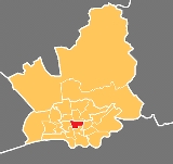
Electoral ward
Moor Park is currently a two-member electoral ward, which in addition to the neighbouring College and DeepdaleDeepdale, Preston
Deepdale is an electoral ward in Preston, Lancashire, England. The ward is home to the Deepdale football stadium of Preston North End. The ward is a predominately urban area of terraced housing, notable for one of the largest Muslim populations in the city....
wards, forms the Preston Central North division of Lancashire County Council
Lancashire County Council
Lancashire County Council is the upper-tier local authority for the non-metropolitan county of Lancashire, England. It currently consists of 84 councillors, and is controlled by the Conservative Party, who won control of the council in the local council elections in June 2009, ending 28 years of...
. The English Martyr’s Catholic Church is within the ward.
Current councillors
| Election | Member | Party | |
|---|---|---|---|
| Preston Council election, 2007 | Frank De Molfetta | Labour Party | |
| Preston Council election, 2010 Preston Council election, 2010 Council elections for the City of Preston, Lancashire were held on 6 May 2010. They coincided with the United Kingdom local elections, 2010. Nineteen electoral wards were fought with those councillors elected in the corresponding elections in 2006 defending their seats due to the "in thirds" system... |
John Collins | Labour Party | |
Demographics
At the 2001 census, Moor Park has a population of 4,919, whilst at the most recent election the electorate was 3,053. Of this figure, 68% described themselves as Christian, with a Muslim population of 5.2%. Whilst the area around Fulwood is largely commuter belt and recent retired properties, the Plungington and Deepdale areas are traditional terraces with multi-occupancy homes increasingly common.Geography
The traditional “grid” terraces in the south of the ward are made up of a number of main roads, including the A6 Garstang Road which itself runs from the ward’s northern boundary at Lytham Road, to the outskirts of the city centre. The component of the electoral ward to the south of Moor Park itself crosses the A6 to take in a number of terraces to St Paul’s Road in an easterly direction towards Deepdale. From the main Blackpool Road heading north, the houses are largely semi- and true detached homes in the suburban style.External links
See also
- Preston local electionsPreston local electionsOne third of Preston City Council in Lancashire, England is elected each year, followed by one year without election.-Political control:Since the first election to the council in 1973 political control of the council has been held by the following parties:...
- Districts of PrestonDistricts of PrestonPreston is a city of Lancashire, England. The districts of Preston vary in size and shape, many of which reflect the districts developed from former villages and boroughs which now lie within the boundaries of the city of Preston. Districts of Preston have little administrative purpose: for local...