
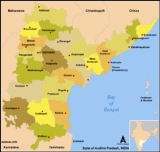
Districts of Andhra Pradesh
Encyclopedia
The state of Andhra Pradesh
is divided into 23 districts which are listed below.

Andhra Pradesh
Andhra Pradesh , is one of the 28 states of India, situated on the southeastern coast of India. It is India's fourth largest state by area and fifth largest by population. Its capital and largest city by population is Hyderabad.The total GDP of Andhra Pradesh is $100 billion and is ranked third...
is divided into 23 districts which are listed below.
| Code | District | Headquarters | Population (2001) | Area (km²) | Density (/km²) | Official website |
| AD | Adilabad Adilabad district Adilabad District is a district in Andhra Pradesh, India. The district headquarters is at Adilabad town. A famous Temple of the Goddess Saraswathi, the Hindu Goddess of Education, is located here in the town of Basara.-Origin of name:... |
Adilabad Adilabad Adilabad , is a town and a municipality in Adilabad district in the state of Andhra Pradesh, India. It has a population of 108,233 . It is the headquarters of the district of the same name.-History:... |
2,479,347 | 16,105 | 154 | http://adilabad.nic.in/ |
| AN | Anantapur Anantapur district Anantapur District , ) is one of the 23 districts in Andhra Pradesh, India. The district headquarters is Anantapur City. It is currently a part of the Red Corridor.- Geography :... |
Anantapur | 3,639,304 | 19,130 | 190 | http://anantapur.nic.in/ |
| CH | Chittoor Chittoor district Chittoor District , also known as Chittur, is a district of India's Andhra Pradesh state. The district headquarters is Chittoor City. The district has a population of 4,170,468 according to 2011 census of India. Chittoor district is famous for the Tirupati, Kanipakam and Sri Kalahasti temples... |
Chittoor Chittoor Chittoor also known as Chittur, is a City and municipal corporation located in the Chittoor District of Andhra Pradesh, India. It is conveniently located on major highways linking the cities of Bangalore and Chennai.... |
3,735,202 | 15,152 | 247 | http://chittoor.nic.in/ |
| EG | East Godavari | Kakinada Kakinada Kakinada is a city and a municipal corporation in the Indian state of Andhra Pradesh. It is located east of the state capital, Hyderabad. It is also the headquarters of East Godavari district. It is nicknamed "Fertilizer City" , "Pensioner's Paradise" and "Second Madras"... |
4,872,622 | 10,807 | 451 | http://eastgodavari.nic.in/ |
| GU | Guntur Guntur district Guntur district is located in Andhra Pradesh along the east coast of Bay of Bengal. The district has a coastline of around 100 kilometers. Guntur City is the largest city in the district and administrative center of Guntur District. The district is a major center for learning.-Etymology:There are... |
Guntur Guntur Guntur , is a city and a municipal corporation in the Indian state of Andhra Pradesh, located to the north and west of the Bay of Bengal. It is approximately to the south of the national capital, New Delhi and south east of state capital, Hyderabad. Guntur is the fourth largest city in Andhra... |
4,405,521 | 11,391 | 387 | http://guntur.nic.in/ |
| HY | Hyderabad Hyderabad District, India Hyderabad District , is a district in the state of Andhra Pradesh in India that contains a part of the metropolitan area of Hyderabad. It is headed by a district collector who is drawn from the IAS cadre and is appointed by the state government.-History:... |
Hyderabad | 3,686,460 | 217 | 16,988 | http://hyderabad.nic.in/ |
| CU | YSR | Kadapa Kadapa Kadapa , formerly Cuddapah, is a city in the south-central part of Andhra Pradesh, India . The city's name originated from the Telugu word "Gadapa" meaning threshold or gate... |
2,573,481 | 15,359 | 168 | http://kadapa.nic.in/ |
| KA | Karimnagar | Karimnagar Karimnagar As of 2011 India census Estimation, Karimnagar city had a population of 2,99,660. Males constitute 51% of the population and females 49% has an average literacy rate of 86.75%, higher than the national average of 74.04%: male literacy is 92.61%, and female literacy is 80.79%. In Karimnagar, 12% of... |
3,477,079 | 11,823 | 294 | http://karimnagar.nic.in/ |
| KH | Khammam Khammam district Khammam District is a district in Andhra Pradesh, India. It had a population of 2,565,412 of which 19.81% were urban as of 2001 census. Khammam town is the district headquarters. The present name of Khammam is derived from the old name Kammamet. Later it was called Khammam Mettu and subsequently... |
Khammam Khammam Khammam , is the headquarters of the Khammam District in Andhra Pradesh state of India and is located about east of state capital, Hyderabad... |
2,565,412 | 16,029 | 160 | http://khammam.nic.in/ |
| KR | Krishna Krishna district Krishna District is a district of India's Andhra Pradesh state. It is named after the Krishna River, the third longest river that flows within India, flows through the district and joins Bay of Bengal here in this district. It has a population of 4,529,009 of which 32.08% is urban as of... |
Machilipatnam Machilipatnam Machilipatnam is a city and a special grade municipality in the Krishna district, Andhra Pradesh, India. It is located south east of state capital, Hyderabad.-History:... |
4,218,416 | 8,727 | 483 | http://krishna.nic.in/ |
| KU | Kurnool Kurnool district Kurnool District is a district in the state of Andhra Pradesh, India, located in the west-central part of the state on the southern banks of the Tungabhadra and Handri rivers. The town of Kurnool is currently the headquarters of the district... |
Kurnool Kurnool Kurnool is located at . It has an average elevation of 273 metres .Kurnool lies on the banks of the Tungabhadra River. The Handry and Neeva rivers also flow through the city. The K.C... |
3,512,266 | 17,658 | 199 | http://kurnool.nic.in/ |
| MA | Mahbubnagar Mahbubnagar district Mahabubnagar or Mahboobnagar , also known as Palamooru is a district in the Andhra Pradesh state of India, in the Telangana region. It is named after its largest city and district headquarters, Mahabubnagar.It is the second largest district in the state in terms of area... |
Mahabubnagar | 3,506,876 | 18,432 | 190 | http://mahabubnagar.nic.in/ |
| ME | Medak(Sangareddi) Medak district Medak District is located in the state of Andhra Pradesh, India. Sangareddy is the district headquarters of Medak. The district had a population of 2,670,097, of which 14.36% were urban as of 2001... |
Sangareddi Sangareddi Sangareddi or Sangareddy ; earlier known as Sangareddypeta) is the district headquarters of Medak district in the state of Andhra Pradesh in India. It is about 72 km from Medak and 55 km from Hyderabad and is located on Hyderabad-Mumbai Highway . Manjira Wildlife and Bird Sanctuary... |
2,662,296 | 9,699 | 274 | http://medak.nic.in/ |
| NA | Nalgonda Nalgonda district Nalgonda / Nallagonda District is a district in Andhra Pradesh. It has a population of 3,483,648 of which 13.32% is urban as of 2001.-Etymology:Its name is derived from two Telugu words Nalla & Konda i.e... |
Nalgonda Nalgonda Nalgonda is a town and a municipality in Nalgonda district in the Indian state of Andhra Pradesh. Its name is derived from two Telugu words Nalla and Konda . Nalgonda in the past is referred to as Nilagiri. During the period of Bahamani kingdom, it had been renamed as Nallagonda... |
3,238,449 | 14,240 | 227 | http://nalgonda.nic.in/ |
| NE | Nellore | Nellore Nellore Nellore , is a city and headquarters of Potti Sri Ramulu Nellore District, formerly Nellore district.And in the state of Andhra Pradesh. Ancient name of Nellore was "Vikrama Simhapuri".... |
2,659,661 | 13,076 | 203 | http://nellore.nic.in/ |
| NI | Nizamabad Nizamabad district Nizamabad District is located in the north-western region in the state of Andhra Pradesh, India. It is also known as Induru. Nizamabad is the current and official name of the district.... |
Nizamabad | 2,342,803 | 7,956 | 294 | http://nizamabad.nic.in/ |
| PR | Prakasam Prakasam district Prakasam District is an administrative district in the state of Andhra Pradesh, in India. The district headquarters is located at Ongole City... |
Ongole | 3,054,941 | 17,626 | 173 | http://prakasam.nic.in/ |
| RA | Rangareddi Rangareddi district K. V. Ranga Reddy District is a district in the state of Andhra Pradesh, India. Ranga Reddy District was formed in 1978 when it was split from Hyderabad district. The district has an area of 7,493 km², and a population of 3,575,064 of which 54.20% is urban as of 2001... |
Hyderabad | 3,506,670 | 7,493 | 468 | http://rangareddy.nic.in/ |
| SR | Srikakulam Srikakulam district Srikakulam District , formerly known as Chicacole, is the extreme northeastern District of Andhra Pradesh, situated within the geographic co-ordinates of 18°-20’ and 19°-10’ N and 83°-50’ and 84°-50’ E... |
Srikakulam Srikakulam Srikakulam is a town, municipality and headquarters of Srikakulam district in the north-eastern Andhra Pradesh, India. It is part of Srikakulam Assembly constituency and Srikakulam Parliament Constituency. Srikakulam was formerly called as Gulshanabad during Muslim rule and was headquarter of... |
2,528,491 | 5,837 | 433 | http://srikakulam.nic.in/ |
| VS | Vishakhapatnam Visakhapatnam district Visakhapatnam district , also known as Visakha Zilla, is an administrative division of Andhra Pradesh, India. The administrative headquarters of the Visakhapatnam District is Visakhapatnam.-Post-Independence:... |
Vishakhapatnam | 3,789,823 | 11,161 | 340 | http://visakhapatnam.nic.in/ |
| VZ | Vizianagaram Vizianagaram district Vizianagaram district , also known as Vijayanagaram district is one of the northern coastal districts of Andhra Pradesh, India. Vizianagaram town is the district headquarters... |
Vizianagaram Vizianagaram Vizianagaram is the main city of the Vizianagaram District of north-eastern Andhra Pradesh in southern India. Vizianagaram district was formed on 1 June 1979, with some parts carved from the neighbouring districts of Srikakulam and Visakhapatnam. It is, at present, the largest municipality of... |
2,245,103 | 6,539 | 343 | http://vizianagaram.nic.in/ |
| WA | Warangal Warangal district Warangal District is located in the northern area in the state of Andhra Pradesh, India. The administrative seat is Warangal.Warangal District has an area of 12,846 km², and a population of 3,246,004 of which 19.20% was urban as of 2001... |
Warangal Warangal Warangal is a city and a municipal corporation in Warangal district in the Indian state of Andhra Pradesh. Warangal is located northeast of the state capital of Hyderabad and is the administrative headquarters of Warangal District. This district is a combination of three cities: Warangal,... |
3,231,174 | 12,846 | 252 | http://warangal.nic.in/ |
| WG | West Godavari | Eluru Eluru Eluru is a city and a municipal corporation in the state of Andhra Pradesh, India. It is the headquarters of West Godavari district and has a population of 5,15,343 approximately. Eluru is situated on the national highway NH 5 connecting Vijayawada and Visakhapatnam and about east of state... |
3,796,144 | 7,742 | 490 | http://wgodavari.nic.in/ |