

Dharla River
Encyclopedia
Bangladesh
Bangladesh , officially the People's Republic of Bangladesh is a sovereign state located in South Asia. It is bordered by India on all sides except for a small border with Burma to the far southeast and by the Bay of Bengal to the south...
's trans-boundary river
Trans-boundary river
A trans-boundary river is a river that crosses at least one political border, either a border within a nation or an international boundary. The country of Bangladesh has the greatest number of these rivers, almost all of which cross national boundaries....
s. It originates in the Himalayas
Himalayas
The Himalaya Range or Himalaya Mountains Sanskrit: Devanagari: हिमालय, literally "abode of snow"), usually called the Himalayas or Himalaya for short, is a mountain range in Asia, separating the Indian subcontinent from the Tibetan Plateau...
where it is known as the Jaldhaka River
Jaldhaka River
The Jaldhaka River is a trans-boundary river with a length of 192 kilometres that originates in southeastern Sikkim in the eastern Himalayas and flows through Bhutan and the Darjeeling, Jalpaiguri and Cooch Behar districts of West Bengal, India...
, and then it flows through the Jalpaiguri
Jalpaiguri District
Jalpaiguri district is the largest district of North Bengal, covering an area 6,245 km2. It is situated between 26° 16' and 27° 0' North latitudes and 88° 4' and 89° 53' East longitudes...
and Cooch Behar
Cooch Behar District
Cooch Behar district is a district of the state of West Bengal, India, as well as the district's namesake town. During the British Raj, the town of Cooch Behar was the seat of a princely state of Koch Bihar, ruled by the Koch dynasty....
districts of West Bengal
West Bengal
West Bengal is a state in the eastern region of India and is the nation's fourth-most populous. It is also the seventh-most populous sub-national entity in the world, with over 91 million inhabitants. A major agricultural producer, West Bengal is the sixth-largest contributor to India's GDP...
, India
India
India , officially the Republic of India , is a country in South Asia. It is the seventh-largest country by geographical area, the second-most populous country with over 1.2 billion people, and the most populous democracy in the world...
, one of the seven main rivers to do so. Here the river enters Bangladesh
Bangladesh
Bangladesh , officially the People's Republic of Bangladesh is a sovereign state located in South Asia. It is bordered by India on all sides except for a small border with Burma to the far southeast and by the Bay of Bengal to the south...
through the Lalmonirhat District
Lalmonirhat District
The district of Lalmonirhat consists 3038 mosques, 512 temples, 43 Buddhist temples and 12 churches.-Tourism:There are a number of tourist attractions and archaeological sites in Lalmonirhat...
and joins with the Jaldhaka River
Jaldhaka River
The Jaldhaka River is a trans-boundary river with a length of 192 kilometres that originates in southeastern Sikkim in the eastern Himalayas and flows through Bhutan and the Darjeeling, Jalpaiguri and Cooch Behar districts of West Bengal, India...
and flows as the Dharla River until it empties into the Brahmaputra River
Brahmaputra River
The Brahmaputra , also called Tsangpo-Brahmaputra, is a trans-boundary river and one of the major rivers of Asia. It is the only Indian river that is attributed the masculine gender and thus referred to as a in Indo-Aryan languages and languages with Indo-Aryan influence...
near the Kurigram District
Kurigram District
Kurigram is a district in Northern Bangladesh. It is located in the Rangpur Division.-Geography:Kurigram District is located in the northern region of Bangladesh along the border of India. The area of this district is 2,296.10 km² and population is 1,782,277...
. Near Patgram Upazila
Patgram Upazila
Patgram is an Upazila of Lalmonirhat District in the Division of Rajshahi, Bangladesh.-Geography:Patgram is located at . It has 30271 units of house hold and total area 261.51 km².-Demographics:...
, it again flows easternly back into India
India
India , officially the Republic of India , is a country in South Asia. It is the seventh-largest country by geographical area, the second-most populous country with over 1.2 billion people, and the most populous democracy in the world...
. Suddenly it turns south and enters Bangladesh for the second time through Phulbari Upazila
Phulbari Upazila
Phulbari Upazila can refer to:In Bangladesh:* Phulbari Upazila, Dinajpur* Phulbari Upazila, Kurigram* Fulbaria Upazila, MymensinghElsewhere:* Phulbari, Nepal...
of Kurigram District
Kurigram District
Kurigram is a district in Northern Bangladesh. It is located in the Rangpur Division.-Geography:Kurigram District is located in the northern region of Bangladesh along the border of India. The area of this district is 2,296.10 km² and population is 1,782,277...
and continues a slow meandering course.
The average depth of river is 12 feet (3.7 m) and maximum depth is 39 feet (11.9 m), in origin of Kurigram.
Erosion by the rivers Dharla and Jamuna took a serious turn in Lalmonirhat in 2007.
In Lalmonirhat, about two kilometres of seven kilometre-long flood control embankment was devoured by the Dharla. Three mosques, two temples, a madrassah and a primary school, and a vast tract of cultivable land with crops were devoured by the river, rendering about three thousand people homeless.
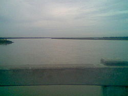
There is a park beside the Dharla at Kurigram. There also is a bridge. The river is full during the monsoon
Monsoon
Monsoon is traditionally defined as a seasonal reversing wind accompanied by corresponding changes in precipitation, but is now used to describe seasonal changes in atmospheric circulation and precipitation associated with the asymmetric heating of land and sea...
season but has only knee-deep water in summer. Deposition of silt has led to the formation of many small islands (chars) in the river.