
Derbyshire Dales
Encyclopedia
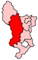
Derbyshire Dales is a local government district
in Derbyshire
, England. Much of the district is situated in the Peak District
, although most of its population lies along the River Derwent
.
The borough borders the districts of High Peak, Amber Valley
, North East Derbyshire
and South Derbyshire
in Derbyshire and also Sheffield
in South Yorkshire
.
The district offices are in Matlock. It was formed on 1 April 1974, originally under the name of West Derbyshire. The district adopted its current name in 1988. The district was a merger of Ashbourne
, Bakewell
, Matlock and Wirksworth
urban district
s along with Ashbourne Rural District and Bakewell Rural District.
Following their review of parliamentary representation in Derbyshire, the Boundary Commission for England has formed a new constituency called Derbyshire Dales
.
Non-metropolitan district
Non-metropolitan districts, or colloquially shire districts, are a type of local government district in England. As created, they are sub-divisions of non-metropolitan counties in a so-called "two-tier" arrangement...
in Derbyshire
Derbyshire
Derbyshire is a county in the East Midlands of England. A substantial portion of the Peak District National Park lies within Derbyshire. The northern part of Derbyshire overlaps with the Pennines, a famous chain of hills and mountains. The county contains within its boundary of approx...
, England. Much of the district is situated in the Peak District
Peak District
The Peak District is an upland area in central and northern England, lying mainly in northern Derbyshire, but also covering parts of Cheshire, Greater Manchester, Staffordshire, and South and West Yorkshire....
, although most of its population lies along the River Derwent
River Derwent, Derbyshire
The Derwent is a river in the county of Derbyshire, England. It is 66 miles long and is a tributary of the River Trent which it joins south of Derby. For half its course, the river flows through the Peak District....
.
The borough borders the districts of High Peak, Amber Valley
Amber Valley
Amber Valley is a local government district and borough in Derbyshire, England. It takes its name from the River Amber and covers a semi-rural area with a number of small towns formerly based around coal mining and engineering...
, North East Derbyshire
North East Derbyshire
North East Derbyshire is a local government district in Derbyshire, England. It borders the districts of Chesterfield, Bolsover, Amber Valley and Derbyshire Dales in Derbyshire, and Sheffield and Rotherham in South Yorkshire....
and South Derbyshire
South Derbyshire
South Derbyshire is a local government district in Derbyshire, England. It contains a third of the National Forest, and the council offices are in Swadlincote....
in Derbyshire and also Sheffield
Sheffield
Sheffield is a city and metropolitan borough of South Yorkshire, England. Its name derives from the River Sheaf, which runs through the city. Historically a part of the West Riding of Yorkshire, and with some of its southern suburbs annexed from Derbyshire, the city has grown from its largely...
in South Yorkshire
South Yorkshire
South Yorkshire is a metropolitan county in the Yorkshire and the Humber region of England. It has a population of 1.29 million. It consists of four metropolitan boroughs: Barnsley, Doncaster, Rotherham, and City of Sheffield...
.
The district offices are in Matlock. It was formed on 1 April 1974, originally under the name of West Derbyshire. The district adopted its current name in 1988. The district was a merger of Ashbourne
Ashbourne, Derbyshire
Ashbourne is a small market town in the Derbyshire Dales, England. It has a population of 10,302.The town advertises itself as 'The Gateway to Dovedale'.- Local customs :...
, Bakewell
Bakewell
Bakewell is a small market town in the Derbyshire Dales district of Derbyshire, England, deriving its name from 'Beadeca's Well'. It is the only town included in the Peak District National Park, and is well known for the local confection Bakewell Pudding...
, Matlock and Wirksworth
Wirksworth
Wirksworth is a small market town in Derbyshire, England, with a population of over 9,000.The population of the Wirksworth area including Cromford, Bolehill and Middleton-by-Wirksworth is about 12,000. Wirksworth is listed in the Domesday Book in 1086. Within it is the source of the River...
urban district
Urban district
In the England, Wales and Ireland, an urban district was a type of local government district that covered an urbanised area. Urban districts had an elected Urban District Council , which shared local government responsibilities with a county council....
s along with Ashbourne Rural District and Bakewell Rural District.
Following their review of parliamentary representation in Derbyshire, the Boundary Commission for England has formed a new constituency called Derbyshire Dales
Derbyshire Dales (UK Parliament constituency)
Derbyshire Dales is a county constituency represented in the House of Commons of the Parliament of the United Kingdom. It elects one Member of Parliament by the first past the post voting system....
.
Places
- Alsop-en-le-Dale, Ashford-in-the-WaterAshford-in-the-WaterAshford-in-the-Water is a village in the Derbyshire Peak District, England, and on the River Wye. It is known for the quarrying of Ashford Black Marble , and for the Maiden's Garlands made to mark the deaths of virgins in the village until 1801. Some of these are preserved in the parish church...
, AshbourneAshbourne, DerbyshireAshbourne is a small market town in the Derbyshire Dales, England. It has a population of 10,302.The town advertises itself as 'The Gateway to Dovedale'.- Local customs :... - BakewellBakewellBakewell is a small market town in the Derbyshire Dales district of Derbyshire, England, deriving its name from 'Beadeca's Well'. It is the only town included in the Peak District National Park, and is well known for the local confection Bakewell Pudding...
, BaslowBaslowBaslow is a village in Derbyshire, England, in the Peak District, lying between Sheffield and Bakewell. It is situated on the River Derwent just north of Chatsworth House. A seventeenth century bridge spans the river in the village, alongside which is a contemporary toll house...
, BeeleyBeeleyBeeley is a village and civil parish in the Derbyshire Dales district of northern Derbyshire, near Bakewell. It is on the B6012 road, between Rowsley and Edensor....
, BigginBigginBiggin can refer to:*Biggin , Derbyshire, in the Peak District*Biggin Hill a town in London*London Biggin Hill Airport an airport near Biggin Hill, London*Biggin by Hulland, Derbyshire, near Hulland*Biggin, North Yorkshire...
, BirchoverBirchoverBirchover is a village and civil parish in the Peak District National Park, in Derbyshire, England. It is about five miles north-west of Matlock, and according to the 2001 UK census had a population of 362...
, BonsallBonsall, DerbyshireBonsall is a village and civil parish in the Derbyshire Dales on the edge of the Peak District.-Geography:Bonsall is about from Matlock and about from Derby...
, BradbourneBradbourneBradbourne is a village and civil parish in the Derbyshire Dales district of Derbyshire, England. The village is just outside the Peak District National Park, and is 5 miles north of Ashbourne....
, BradwellBradwell, DerbyshireBradwell is a village in the Derbyshire Peak District of England. It lies south of the main body of the Hope Valley, but is usually included among its settlements....
, BrassingtonBrassingtonBrassington is a village 16 miles north-north-west of Derby, between Wirksworth and Ashbourne, and has a population of about 580.The name, spelled Branzingtune in the Domesday Book, is thought to mean "Brand's people's place"...
, BrettonBretton, DerbyshireBretton, Derbyshire is a hamlet in Derbyshire, England. Set on a ridge with a panoramic view, it has few inhabitants but boasts a pub called the Barrel Inn, and the .Some local information is available .... - CalverCalverCalver is a village in Derbyshire, England.-Overview:Calver is a small village situated in the Derwent Valley, Derbyshire. The village is bordered by the River Derwent and intersected by the A623 trunk road, responsible for carrying traffic between Manchester to the west, Sheffield to the north &...
, CarsingtonCarsingtonCarsington is a village in the middle of the Derbyshire Dales, England; it adjoins the hamlet of Hopton, close to the historic town of Wirksworth and village of Brassington.Population - 111-History:...
, ChatsworthChatsworth, DerbyshireChatsworth is a civil parish in Derbyshire, England, within the area of the Derbyshire Dales and the Peak District National Park.The population is largely in and around Chatsworth House and is considered to be too low to justify a parish council...
, ChelmortonChelmortonChelmorton is a village situated in the Peak National Park, the Derbyshire Dales and the White Peak. The village is often described as linear with medieval strip fields radiating horizontally from a main street, rising up a gradual hill....
, CromfordCromfordCromford is a village, two miles to the south of Matlock in the Derbyshire Dales district in Derbyshire, England. It is principally known for its historical connection with Richard Arkwright, and the Cromford Mill which he built here in 1771...
, CurbarCurbarCurbar is a village in the Derbyshire Dales district of Derbyshire, a mile north of Baslow, close to Calver on the A623.The village has a street with the highest average house value in Derbyshire. Close to the east are the popular rock-climbing escarpments of Curbar Edge and Baslow Edge. To the... - Darley DaleDarley DaleDarley Dale, also known simply as Darley, is a town in Derbyshire, England, with a population of around 6,000 people. It lies north of Matlock, on the River Derwent and the A6 road.- History :...
- Earl SterndaleEarl SterndaleEarl Sterndale is a village in the Upper Dove Valley in the Peak District, Derbyshire, England, UK, situated near the River Dove, 5 miles south of Buxton, and 8 miles west of Bakewell. It sits 1100 feet above sea level. The farms surrounding the village were medieval monastic granges in the care of...
, EdensorEdensorEdensor is a village in Derbyshire, England. It is the closest village to Chatsworth House and much of it belongs to the Dukes of Devonshire. Originally the village was close to the River Derwent immediately below Chatsworth, but the Dukes had it moved out of sight over a hill, apart from one...
, EltonElton, DerbyshireElton is an a village in Derbyshire, England and in the Peak District. There are no shops situated in the village but Elton has a small post office, cafe, church, school and a sports field. Its nearest towns are Bakewell and Matlock...
, EyamEyamEyam is a small village in Derbyshire, England. The village is best known for being the "plague village" that chose to isolate itself when the plague was discovered there in August 1665, rather than let the infection spread... - Fenny BentleyFenny BentleyFenny Bentley is a village close to Dovedale, Derbyshire, England. It lies two north of Ashbourne, on the A515 Buxton to Ashbourne Road.The Church of St Edmund at Fenny Bentley probably dates back to the 14th century but it was very heavily restored in the 19th century when the spire was added to...
, FoolowFoolowFoolow is a village in the Derbyshire Peak District.The village green contains an ornate cross, similar to the one at Wheston but possibly of later date. It is inscribed with the date 1868, when it was moved from the site of the Wesleyan Reform Chapel and its shaft was replaced. A former bull...
, FroggattFroggatt-People:* Jack Froggatt , an English football player* Joanne Froggatt , a British actress* Kathryn Froggatt, former member of the band Wheatus* Sir Leslie Froggatt , British-born Australian businessman... - Great HucklowGreat HucklowGreat Hucklow is a small village in the Derbyshire Peak District which nestles under Hucklow Edge between the villages of Tideswell and Bradwell. It has a population of about 100. The area is now mainly agricultural, but the village was formerly a centre of the Derbyshire lead mining industry...
, Great LongstoneGreat LongstoneGreat Longstone with Little Longstone is one of two villages in the local government district of Derbyshire Dales in Derbyshire, England.-History:...
, GrindlefordGrindlefordGrindleford is a village and parish in the county of Derbyshire, in the East Midlands of England. It lies at an altitude of in the valley of the River Derwent in the Peak District National Park. On the west side of the valley is the high Sir William Hill, and to the south-east lies the gritstone... - HassopHassopHassop is a village in the local government district of Derbyshire Dales in Derbyshire, England.It developed around a number of lead mines, with such names as "The Brightside", "Backdale", "Harry Bruce", "Waterhole" and "Whitecoe", which lasted until the mid-nineteenth century.The local landowners...
, HathersageHathersageHathersage is a village in the Derbyshire Peak District, in England. It lies on the north bank of the River Derwent, approximately 10 miles west of Sheffield...
, HognastonHognastonHognaston is a small village and civil parish in Derbyshire, East Midlands, England.Hognaston has a population of approximately 200; and has a play area, pub, church and a village hall....
, HartingtonHartingtonHartington is a village in the Derbyshire Peak District, England, lying on the River Dove close to the Staffordshire border. According to the 2001 census, the parish of Hartington Town Quarter, which also includes Pilsbury, had a population of 345... - Kirk IretonKirk IretonKirk Ireton is a village in Derbyshire, England. It is located 4 miles south of Wirksworth nestling on a hillside, 700ft above sea level. Ireton is a corruption of Hyre-Tun in the Saxon and means 'The Irishman's Enclosure'. 'Kirk' was added after the Norman invasion and the building of the church...
, KnivetonKnivetonKniveton is a village in Derbyshire, England. It is located in the Peak District, north east of Ashbourne, 6 south west from Wirksworth and from London... - Little HucklowLittle HucklowThe parish of Little Hucklow is situated in north Derbyshire. Whilst it is a separate civil parish in the Derbyshire Dales District, the Parish Council is joint with Great Hucklow, and Grindlow. The parish consists of the village of Little Hucklow and the hamlets of Coplow Dale and Windmill. The...
, LittonLitton, DerbyshireLitton is a village in the Derbyshire Peak District of England. It is one mile from Tideswell and six miles from Bakewell.The locals will tell you "It's 1000 feet up - minus a boy scout". It has a village hall, a village shop, a small primary school, a post office run by a co-operative of villagers... - Matlock, Matlock BathMatlock BathMatlock Bath is a village south of Matlock in Derbyshire, England. Built along the River Derwent, it developed, in the 19th century, as a spa town and still thrives on tourism.-History:In 1698 warm springs were discovered and a Bath House was built...
, Middleton-by-WirksworthMiddleton-by-WirksworthMiddleton-by-Wirksworth is an upland village lying approximately one mile NNW of Wirksworth, Derbyshire, formerly known for its lead mines and high quality limestone quarries, including the remarkable underground quarry site at Middleton Mine...
, Middleton-by-YoulgreaveMiddleton-by-YoulgreaveMiddleton, often known as Middleton-by-Youlgreave or Middleton-by-Youlgrave to distinguish it from nearby Middleton-by-Wirksworth, is a village in the Peak District, Derbyshire, England. It lies south west of Youlgreave, above the River Bradford...
, MonyashMonyashMonyash is a village in the Derbyshire Peak District about five miles west of Bakewell.Monyash lies at an elevation of 300m above sea level, and has a population of about 280 people. The village is located in a shallow hollow in the limestone plateau at the head of Lathkill Dale, which starts just... - Over HaddonOver HaddonOver Haddon is a small village in Derbyshire, England. It is located near the small town of Bakewell, near the B5055 road.Over Haddon overlooks Lathkill Dale and the River Lathkill, which may be crossed by a clapper bridge on a footpath running south from the village. It has two churches, a public...
- ParwichParwichParwich is a village and parish in the Derbyshire Dales, located 7 miles to the north of Ashbourne. Its population is estimated at slightly over 500 inhabitants....
- RowsleyRowsleyRowsley is a village on the A6 road in the English county of Derbyshire.It is at the point where the River Wye flows into the River Derwent and prospered from mills on both.-Overview:...
- Stanton-in-Peak, Stoney MiddletonStoney MiddletonStoney Middleton is a village in the Derbyshire Dales district of Derbyshire, England. It lies in the White Peak area of the Peak District southeast of Eyam and northwest of Calver, on the A623 road at the foot of the limestone valley of Middleton Dale....
, SudburySudbury, DerbyshireSudbury is a village and civil parish in Derbyshire, England, located approximately to the south of Ashbourne. It is part of the Derbyshire Dales district. The £0.5m A50 bypass opened in 1972... - TaddingtonTaddingtonTaddington is a village in Derbyshire, England. It lies over 1100 feet above sea level, on the former A6 road between Buxton and Bakewell, in the Derbyshire Dales district. To the east, the A6 runs through Taddington Dale, while Taddington Moor lies to the west.Taddington grew around farming and...
, TansleyTansleyTansley is a village on the southern edge of the Derbyshire Peak District, two miles east of Matlock.-History:Tansley is recorded in the Domesday Book as Tanslege, and its name comes from the combination of the Old English words lega, meaning "wood or glade" and tan meaning "a branch of a...
, ThorpeThorpe, DerbyshireThorpe is a village and civil parish in the English county of Derbyshire; it is on the Derbyshire/Staffordshire border, on the east bank of the River Dove, about four miles north of Ashbourne....
, TideswellTideswellTideswell is a village and civil parish in the Peak District of Derbyshire, in England. It lies east of Buxton on the B6049, in a wide dry valley on a limestone plateau, at an altitude of above sea level, and is within the District of Derbyshire Dales...
, TissingtonTissingtonTissington is a village in Derbyshire, England. It is part of the estate of Tissington Hall, owned by the FitzHerbert family since 1465. It is regarded as one of the most picturesque English villages and is a popular tourist attraction, particularly during its well dressing week. It also gives its... - WardlowWardlowWardlow is a parish and linear village in the Derbyshire Dales two miles from Tideswell, Derbyshire, England. The small village contains the church of the Good Shepherd, and within the settlement is the small hamlet of Wardlow Mires which contains a notable pub...
, WensleyWensley, DerbyshireWensley is a hamlet in Derbyshire, England. It is located of Matlock, on the B5057 road.The villagers in Wensley were employed in the lead mining industry in the fields around the village in the 18th and 19th century after the London Lead Company obtained the mining rights in the 1720's.Nearest...
, WinsterWinsterWinster is a former lead-mining village in the Derbyshire Dales about from Matlock and from Bakewell at an altitude of approx . The village, which lies within the Peak District National Park, has a large number of listed buildings, including the Market House open daily as a National Trust...
, WirksworthWirksworthWirksworth is a small market town in Derbyshire, England, with a population of over 9,000.The population of the Wirksworth area including Cromford, Bolehill and Middleton-by-Wirksworth is about 12,000. Wirksworth is listed in the Domesday Book in 1086. Within it is the source of the River... - YoulgreaveYoulgreaveYoulgreave or Youlgrave is a village in the Derbyshire Peak District, lying on the River Bradford, four kilometres south of Bakewell. Both spellings are used on different local signposts and on different maps. The name possibly derives from "yellow grove" , though was historically called "Giolgrave"...