
Departments of Colombia
Encyclopedia
Colombia
is an unitary republic formed by thirty-two departments (Spanish
: departamentos, sing. departamento
) and a Capital District (Distrito Capital). Each department has a Governor (gobernador) and a Department Assembly (Asamblea Departamental), elected by popular vote for a four-year period. The governor cannot be re-elected in consecutive periods. Departments are country subdivisions and are granted a certain degree of autonomy.
Departments are formed by a grouping of municipalities
(municipios, sing. municipio
). Municipal government is headed by mayor
(alcalde) and administered by a Municipal Council
(concejo municipal), both of which are elected for four-year periods.
The Capital District is the country's capital, Bogotá
. Bogotá is partially dependent on the Cundinamarca Department
that surrounds it.
Colombia
Colombia, officially the Republic of Colombia , is a unitary constitutional republic comprising thirty-two departments. The country is located in northwestern South America, bordered to the east by Venezuela and Brazil; to the south by Ecuador and Peru; to the north by the Caribbean Sea; to the...
is an unitary republic formed by thirty-two departments (Spanish
Spanish language
Spanish , also known as Castilian , is a Romance language in the Ibero-Romance group that evolved from several languages and dialects in central-northern Iberia around the 9th century and gradually spread with the expansion of the Kingdom of Castile into central and southern Iberia during the...
: departamentos, sing. departamento
Departamento
Departamento is the Spanish term for a department.As country subdivision it can be found in several countries of Latin America....
) and a Capital District (Distrito Capital). Each department has a Governor (gobernador) and a Department Assembly (Asamblea Departamental), elected by popular vote for a four-year period. The governor cannot be re-elected in consecutive periods. Departments are country subdivisions and are granted a certain degree of autonomy.
Departments are formed by a grouping of municipalities
Municipalities of Colombia
The Municipalities of Colombia are decentralized subdivisions of the Republic of Colombia. Municipalities make up most of the departments of Colombia with 1,119 municipalities...
(municipios, sing. municipio
Municipio
Municipio and Município are terms used for country subdivisions. They are often translated as municipality.-Overview:...
). Municipal government is headed by mayor
Mayor
In many countries, a Mayor is the highest ranking officer in the municipal government of a town or a large urban city....
(alcalde) and administered by a Municipal Council
Municipal council
A municipal council is the local government of a municipality. Specifically the term can refer to the institutions of various countries that can be translated by this term...
(concejo municipal), both of which are elected for four-year periods.
The Capital District is the country's capital, Bogotá
Bogotá
Bogotá, Distrito Capital , from 1991 to 2000 called Santa Fé de Bogotá, is the capital, and largest city, of Colombia. It is also designated by the national constitution as the capital of the department of Cundinamarca, even though the city of Bogotá now comprises an independent Capital district...
. Bogotá is partially dependent on the Cundinamarca Department
Cundinamarca Department
- Origin of the name :The name of Cundinamarca comes from Kundur marqa, an indigenous expression, probably derived from Quechua. Meaning "Condor's Nest", it was used in pre-Columbian times by the natives of the Magdalena Valley to refer to the nearby highlands....
that surrounds it.
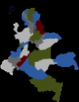
Chart of departments
Each one of the departments of Colombia in the map below links to a corresponding article.| Department | Capital | Area (km²) | Population | Date of establishment | |
|---|---|---|---|---|---|
| * | Bogotá, Distrito Capital Bogotá Bogotá, Distrito Capital , from 1991 to 2000 called Santa Fé de Bogotá, is the capital, and largest city, of Colombia. It is also designated by the national constitution as the capital of the department of Cundinamarca, even though the city of Bogotá now comprises an independent Capital district... |
August 6, 1538 | |||
| 1 | Amazonas | Leticia | October 5, 1991 | ||
| 2 | Antioquia Antioquia Department Antioquia is one of the 32 departments of Colombia, located in the central northwestern part of Colombia with a narrow section that borders the Caribbean Sea. Most of its territory is mountainous with some valleys, much of which is part of the Andes mountain range... |
Medellín Medellín Medellín , officially the Municipio de Medellín or Municipality of Medellín, is the second largest city in Colombia. It is in the Aburrá Valley, one of the more northerly of the Andes in South America. It has a population of 2.3 million... |
1826 | ||
| 3 | Arauca Arauca Department Arauca is a department of Colombia located in the extreme north of the Orinoco part of Colombia , bordering Venezuela. It is bordered to the south by the Casanare River and the Meta River, which separate it from the departments of Casanare and Vichada. To the west borders with the Boyacá Department... |
Arauca Arauca, Arauca Arauca is a municipality and capital city of the Arauca Department of Colombia. Its full name is Villa de Santa Bárbara de Arauca, it is located at N 07° 05′ 25″ - W 70° 45′ 42″. The Municipality of Arauca has a total population of 82,149 .... |
July 4, 1991 | ||
| 4 | Atlántico Atlántico Department Atlántico is a department of Colombia, located in northern Colombia with the Caribbean sea to its north, the Bolívar Department to its south, and the Magdalena Department to its east separated by the Magdalena River... |
Barranquilla Barranquilla Barranquilla is an industrial port city and municipality located in northern Colombia, near the Caribbean Sea. The capital of the Atlántico Department, it is the largest industrial city and port in the Colombian Caribbean region with a population of 1,148,506 as of 2005, which makes it Colombia's... |
1910 | ||
| 5 | Bolívar Bolívar Department Bolívar is a department of Colombia. It was named after one of the original nine states of the United States of Colombia. It is located to the north of the country, extending from the coast at Cartagena near the mouth of the Magdalena River, then south along the river to a border with Antioquia.Its... |
Cartagena | June 15, 1857 | ||
| 6 | Boyacá Boyacá Department Boyacá is one of the 32 Departments of Colombia, and the remnant of one of the original nine states of the "United States of Colombia".Boyacá is centrally located within Colombia, almost entirely within the mountains of the Eastern Cordillera to the border with Venezuela, although the western end... |
Tunja Tunja Tunja is a city and municipality located in the central part of Colombia, in the region of "Alto Chicomocha". As of the 2005 Census it had 152,419 inhabitants. It is the capital of the Department of Boyacá and part of the subregion of the Central Boyacá Province. It is approximately 145 km... |
1858 | ||
| 7 | Caldas Caldas Department Caldas is a department of Colombia named after Colombian patriotic figure Francisco José de Caldas. It's part of the Paisa Region and its capital is Manizales. The population of Caldas is 1,030,062, and its area is 7,291 km²... |
Manizales Manizales Manizales is a city and municipality in central Colombia, capital of Department of Caldas and part of the region of Colombian Coffee-Growers Axis, near the Nevado del Ruiz volcano.... |
1905 | ||
| 8 | Caquetá | Florencia Florencia, Caquetá Florencia is a municipality and capital city of the Department of Caquetá, Colombia. It is the most important city in southeast Colombia because of its population as well as its more than a hundred years of history.... |
1982 | ||
| 9 | Casanare Casanare Department Casanare is a department of Colombia. It is in the central eastern region of the country. Its capital is Yopal. It contains oil fields and an 800 km pipeline leading to the coastal port of Coveñas owned by BP.-Municipalities:# Aguazul# Chameza... |
Yopal Yopal Yopal is a municipality and capital city of the department of Casanare in Colombia.- Geographic information :*Population: 84 293 inhabitants*Elevation: 350 m*Extensión: 2,771 km²*Distance from Bogotá: 387 km*Median temperature: 26 °C-External links:... |
July 4, 1991 | ||
| 10 | Cauca Cauca Department Cauca is a Department of Colombia. Located in the south-western part of the country, facing the Pacific Ocean to the west, the Valle del Cauca Department to the north, Tolima Department to the northeast, Huila Department to the east and the Nariño Department to the south, covering a total area of... |
Popayán Popayán Popayán is the capital of the Colombian department of Cauca. It is located in southwestern Colombia between Colombia's Western Mountain Range and Central Mountain Range... |
June 15, 1857 | ||
| 11 | Cesar Cesar Department Cesar Department or simply Cesar is a department of Colombia located in the north of the country in the Caribbean region, bordering to the north with the Department of La Guajira, to the west with the Department of Magdalena and Department of Bolivar, to the south with Department of Santander, to... |
Valledupar Valledupar Valledupar is a city and municipality in northeastern Colombia. It is the capital of Cesar Department and was founded in 1550 by the Spanish conquistador Hernando de Santana. Its name, Valle de Upar , was established in honor of the Amerindian cacique who ruled the valley; Cacique Upar... |
December, 1967 | ||
| 12 | Chocó Chocó Department Chocó is a department of Colombia known for its large Afro-Colombian population. It is in the west of the country, and is the only Colombian department to have coastlines on both the Pacific Ocean and the Atlantic Ocean. It also has all of Colombia's border with Panama. Its capital is... |
Quibdó Quibdó Quibdó is the capital city of Chocó Department, in western Colombia. The municipality of Quibdó has an area of 3,337.5 km² and a population of 100,000 mainly consisting of Afro Colombians and Zambo Colombians. Quibdo serves a a receptor for those persons affected by the Colombian armed... |
November 3, 1947 | ||
| 13 | Córdoba Córdoba Department Córdoba is a Department of the Republic of Colombia located to the north of this country in the Colombian Caribbean Region. Córdoba faces to the north with the Caribbean sea, to the northeast with the Sucre Department, east with the Bolívar Department and south with the Antioquia Department... |
Montería Montería Montería is a municipality and city located in Northern Colombia and is the capital of the Department of Córdoba. The city is located away from the Caribbean, by the Sinú River. The city and region are famous for their distinct cultural heritages, which include a blend of indigenous Zenú Indians,... |
June 18, 1952 | ||
| 14 | Cundinamarca Cundinamarca Department - Origin of the name :The name of Cundinamarca comes from Kundur marqa, an indigenous expression, probably derived from Quechua. Meaning "Condor's Nest", it was used in pre-Columbian times by the natives of the Magdalena Valley to refer to the nearby highlands.... |
Bogotá Bogotá Bogotá, Distrito Capital , from 1991 to 2000 called Santa Fé de Bogotá, is the capital, and largest city, of Colombia. It is also designated by the national constitution as the capital of the department of Cundinamarca, even though the city of Bogotá now comprises an independent Capital district... |
* | June 15, 1857 | |
| 15 | Guainía Guainía Department Guainía is a department of Colombia. It is in the east of the country, bordering Venezuela and Brazil. Its capital is Inirida. In 1963 Guainía was split off from Vaupés. The northern part and the Inírida River are included in the Orinoco river basin; the rest is part of Amazonia... |
Inirida | July 13, 1963 | ||
| 16 | Guaviare Guaviare Department Guaviare is a department of Colombia. It is in the southern central region of the country. Its capital is San José del Guaviare. Guaviare was created on July 4, 1991 by the new Political Constitution of Colombia... |
San José del Guaviare San José del Guaviare San José del Guaviare is a town and municipality in Colombia, capital of the department of Guaviare by the Guaviare River.-External links: *... |
July 4, 1991 | ||
| 17 | Huila Huila Department Huila is one of the departments of Colombia. It is located in the southwest of the country, and its capital is Neiva.-Geography:The south of the department is located in the Colombian Massif... |
Neiva | 1905 | ||
| 18 | La Guajira | Riohacha Riohacha Riohacha, Rio Hacha or Rio de la Hacha , is a city in the Riohacha Municipality in the northern Caribbean Region of Colombia by the mouth of the Ranchería River and the Caribbean sea, capital city of the La Guajira Department. Founded by conquistador Nikolaus Federmann in 1535, Riohacha was named... |
July 1, 1965 | ||
| 19 | Magdalena Magdalena Department Magdalena is a department of Colombia, located to the north of the country by the Caribbean Sea. The capital of the Magdalena Department is Santa Marta and was named after the Magdalena River... |
Santa Marta Santa Marta Santa Marta is the capital city of the Colombian department of Magdalena in the Caribbean Region. It was founded in July 29, 1525 by the Spanish conqueror Rodrigo de Bastidas, which makes it the oldest remaining city in Colombia... |
July 25, 1824 | ||
| 20 | Meta Meta Department Meta is a department of Colombia. It is close to the geographic center of the country, to the east of the Andean mountains. A large portion of the department, which is also crossed by the Meta River, is covered by a grassland plain known as the Llanos. Its capital is Villavicencio... |
Villavicencio Villavicencio Villavicencio is a city and municipality in Colombia, capital of the Department of Meta, with 361,058 inhabitants. The city is located at 4°08S, 73°40W, 75 km southeast of the Colombian capital city of Bogotá by the Guatiquía river... |
July 1, 1960 | ||
| 21 | Nariño Nariño Department Nariño is a department of Colombia named after Antonio Nariño. It is in the west of the country, bordering Ecuador and the Pacific Ocean.Its capital is Pasto, other important cities include Tumaco, Ipiales.-Municipalities:# Albán# Aldana# Ancuya... |
Pasto Pasto Pasto, officially San Juan de Pasto, is the capital of the department of Nariño, located in southwest Colombia. The city is located in the "Atriz Valley", on the Andes cordillera, at the foot of the Galeras volcano, at an altitude of 8,290 feet above sea level... |
August 6, 1904 | ||
| 22 | Norte de Santander | Cúcuta Cúcuta Cúcuta is a Colombian city, capital of Norte de Santander, in the northeast of the country. Due to its proximity to the Colombian-Venezuelan border, Cúcuta is an important commercial center. The city has the constitutional category of Special District. It is located at the most active... |
July 25, 1910 | ||
| 23 | Putumayo Putumayo Department Putumayo is a department of Colombia. It is in the south-west of the country, bordering Ecuador and Peru. Its capital is Mocoa.The word putumayo comes from the Quechua language. The verb putuy means "to spring forth" or "to burst out", and mayo is a variant of mayu, meaning river... |
Mocoa Mocoa Mocoa is a municipality and capital city of the department of Putumayo in Colombia.The city is located in the northwest of the Putumayo department. The municipality borders the departments of Nariño to the west and Cauca to the north.-External links:... |
1991 | ||
| 24 | Quindío Quindío Department Quindío is a department of Colombia. It is in the western central region of the country, crossed by the Andes mountains. Its capital is Armenia. It is famous for the quality of the coffee plantations, colorful architecture, benign weather, variety of hotel accommodations and touristic landmarks... |
Armenia Armenia, Colombia Armenia is the capital of Quindío, a department in Colombia. The city is located at coordinates 4.5170° north, 75.6830° west, 290 kilometers west of Bogotá. Armenia is a mid-size city located between Bogotá, Medellín and Cali, the 3 largest Colombian cities. The city's area code for phone calls is... |
July 1, 1966 | ||
| 25 | Risaralda Risaralda Department Risaralda is a department of Colombia. It is located in the western central region of the country and part of the Paisa Region. Its capital is Pereira.It was divided from the department of Caldas in 1966... |
Pereira Pereira, Colombia Pereira is the capital city of the Colombian department of Risaralda. It stands in the center of the western region of the country, located in a small valley that descends from a part of the western Andes mountain chain. Its strategic location in the coffee producing area makes the city an urban... |
July 1, 1966 | ||
| 26 | San Andrés and Providencia San Andrés and Providencia Department Archipelago of San Andrés, Providencia and Santa Catalina ; or colloquially San Andrés y Providencia is one of the departments of Colombia. It consists of two island groups about northwest of Colombia and from the coast of Nicaragua, and eight outlying banks and reefs... |
San Andrés | July 4, 1991 | ||
| 27 | Santander Santander Department Santander is a department of Colombia. Santander inherited the name of one of the nine original states of the United States of Colombia. It is located in the central northern part of the country, east of the Magdalena River, bordered to the south and southeast by Boyacá, to the northeast by Norte... |
Bucaramanga Bucaramanga Bucaramanga is a Colombian city, and capital city of the department of Santander, Colombia. Bucaramanga has the fifth largest city economy and sixth largest population in Colombia, with 1,212,656 people in its metropolitan area... |
May 13, 1857 | ||
| 28 | Sucre Sucre Department Sucre is a department in the Caribbean Region of Colombia. The department ranks 27th by area, and it has a population of 772,010, ranking 20th of all the 32 departments of Colombia... |
Sincelejo Sincelejo Sincelejo is the capital and the largest city in the Colombian department of Sucre. It is also the main city in the denominated Región Sabanas , a subdivision of the Caribbean Region of Colombia, and the 23rd biggest city by population in Colombia... |
August 18, 1966 | ||
| 29 | Tolima | Ibagué Ibagué Ibagué is the capital of the department of Tolima in Colombia. It is situated 1,285 m above sea level, on the eastern slopes of the Cordillera Central between the Chipalo and Combeima rivers, tributaries of the Coello River... |
August 4, 1886 | ||
| 30 | Valle del Cauca Valle del Cauca Department Valle del Cauca is a department of Colombia. It is in the western side of the country, facing the Pacific Ocean, and it is considered one of the most important departments in the Republic of Colombia. Its capital is Santiago de Cali... |
Cali Calì Calì, also written in English as Cali, is an Italian surname, widespread mainly in the Ionian side of Sicily.For the surname Calì is assumed the origin of the Greek word kalos , or from its Sanskrit root kali, "time."The surname refers to:... |
April 16, 1910 | ||
| 31 | Vaupés Vaupés Department Vaupés is a department of Colombia in the jungle covered Amazonas Region. It is located in the southeast part of the country, bordering Brazil to the east, the department of Amazonas to the south, Caquetá and Guaviare, and Guainía to the north covering a total area of 54,135 km²... |
Mitú Mitú Mitú is the capital city of the department of Vaupés in Colombia. The town of Mitu is the most remote Capital of Department in Colombia.In November, 1998 an estimated 1,900 FARC guerrilla members of the Eastern Bloc of the FARC-EP tried to take over the town by force, against 120 National Police... |
July 4, 1991 | ||
| 32 | Vichada Vichada Department Vichada is a department of the Republic of Colombia in South America. Vichada is located in the eastern plains of Colombia, in the Orinoquia region within the Orinoco river basin bordering the Bolivarian Republic of Venezuela to the north and east... |
Puerto Carreño Puerto Carreño Puerto Carreño is the departmental capital, and a municipality, of the department of Vichada in the llanos of Colombia.-History:In 1913 the Colombian government created the province of Vichada and it was decided that its capital should be at the convergence of the Orinoco and Meta rivers where... |
July 5, 1991 | ||
| * Estimate includes the country's capital, Bogotá. | |||||
See also
- ISO 3166-2:COISO 3166-2:COISO 3166-2:CO is the entry for Colombia in ISO 3166-2, part of the ISO 3166 standard published by the International Organization for Standardization , which defines codes for the names of the principal subdivisions of all countries coded in ISO 3166-1.Currently for Colombia, ISO 3166-2 codes are...
- List of Colombian flags
- List of country subdivisions
- List of political and geographic subdivisions by total area
- States of ColombiaStates of ColombiaStates of Colombia existed from February 27, 1855 in the Republic of New Granada and the Granadine Confederation, were they were called "federal states"...