

Denali Highway
Encyclopedia
Denali Highway is a lightly traveled, mostly gravel highway in the U.S. state
of Alaska
. It leads from Paxson
on the Richardson Highway
to Cantwell
on the Parks Highway
. Opened in 1957, it was the first road access to Denali National Park (then known as Mount McKinley National Park). Since 1971, primary park access has been via the Parks Highway, which incorporated a section of the Denali Highway from Cantwell to the present-day park entrance. The Denali Highway is 135 miles (217 km) in length.
and extreme dust are common, the recommended speed limit is 30 mi/h.
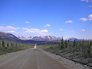 Traveling west, the Denali Highway leaves the Richardson Highway (Alaska Route 4) at Paxson, and climbs steeply up into the foothills of the central Alaska Range. The first 21 miles (33.8 km), to Tangle Lakes
, are paved. Along its length, the highway passes through three of the principal river drainages in Interior Alaska: the Copper River
drainage, the Tanana
/Yukon
drainage and the Susitna
drainage. Along the way, in good weather, there are stunning views of the peaks and glaciers of the central Alaska Range, including Mount Hayes
(13,700 ft), Mount Hess (11,940 ft) and Mount Deborah
(12,688 ft). At MP 15, from the pullout on the south side of the road, in clear weather you can see the Wrangell Mountains
, the Chugach Mountains
and the Alaska Range
.
The first 45 miles (72.4 km) winds through the Amphitheater Mountains, cresting at Maclaren Summit, at 4086 feet (1,245.4 m) the second highest road in Alaska. The road then drops down to the Maclaren River Valley with fine views north to Maclaren Glacier. After crossing the Maclaren River, the road winds through the geologically mysterious Crazy Notch and then along the toe of the Denali Clearwater Mountains to the Susitna River
. After crossing the Susitna River the road extends across the glaciers outwash plains to the Nenana River
, and then down the Nenana River to Cantwell on the George Parks Highway
(Alaska #3).
(MP 22) and Brushkana Creek (MP 104), but there are dozens of pullouts where you can camp on public lands.
Services are scant along this road. Year-round operations include Denali Highway Cabins & Tours (MP 0.2), Maclaren River Lodge (MP 42), Alpine Creek Lodge (MP68) and Backwoods Lodge (MP134); summer-only operations include Tangle River Inn (MP 20) and Gracious House (MP 82) - limited service there summer 2010. Winter travel on the Denali Highway is exclusively by snowmobile and dogsled. Automobile travelers are severely discouraged from attempting to traverse the road in winter; as recently as 1996 three persons died from exposure when snows blocked their progress. The road is cleared by DOT late in April and generally is passable by non-4WD from then until the first snows close it, usually late September on the eastern, tundra end and late October-early November on the lower, boreal forest western end.
 The Tangle Lakes constitute the headwaters of the Delta River
, a popular destination for canoe
ists as it is the launch point of the Delta River Canoe Trail.
The Denali Highway is an important birding destination. It offers road access to alpine terrain – not that common in Alaska – and, in the brief birding season there, good viewing of a number of alpine breeders, including Arctic Warbler, Smith's Longspur, Long-tailed Jaeger, Whimbrel, Surfbird, Lapland Longspur, Horned Lark, Short-eared Owl, Wandering Tattler, Gyrfalcon and much more. A walk north along BLM's Maclaren Summit Trail (MP 39) can be very productive. There are also trumpeter swan
s and various other waterfowl in the lakes and ponds along the route.
Fishing for grayling and lake trout is decent, if not spectacular, in any of the clear water (i.e., unglaciated) streams.
Because the area is hunted heavily, larger mammals are much less common than in Denali National Park, but moose, grizzly bear, and caribou are fairly common. The Nelchina caribou herd, approximately 36,000 animals as of winter 2009–2010, normally passes through this area after calving season ends, and some autumns and winters as many as 16,000 animals can be seen at once. The herd forms an important foodsource for many residents of southcentral Alaska, and visitors eager to view the animals may be competing with hunters. The many lakes along the road are also a destination for duck hunting in the fall.
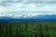
Most of the land along the highway is publicly owned. There are several BLM-maintained trails, and dozens of informal trails. This is a stretch of wild Alaska that is pretty much unspoiled, relatively accessible and beautiful.
U.S. state
A U.S. state is any one of the 50 federated states of the United States of America that share sovereignty with the federal government. Because of this shared sovereignty, an American is a citizen both of the federal entity and of his or her state of domicile. Four states use the official title of...
of Alaska
Alaska
Alaska is the largest state in the United States by area. It is situated in the northwest extremity of the North American continent, with Canada to the east, the Arctic Ocean to the north, and the Pacific Ocean to the west and south, with Russia further west across the Bering Strait...
. It leads from Paxson
Paxson, Alaska
Paxson is a census-designated place in Valdez-Cordova Census Area, Alaska, United States. As of the 2000 census, its population was 43. It is located on the Richardson Highway at the junction with the Denali Highway.-Geography:...
on the Richardson Highway
Richardson Highway
The Richardson Highway is a highway in the U.S. state of Alaska, running 368 miles from Valdez to Fairbanks. It is marked as Alaska Route 4 from Valdez to Delta Junction and as Alaska Route 2 from there to Fairbanks. It is also connects segments of Alaska Route 1 between the Glenn Highway and the...
to Cantwell
Cantwell, Alaska
Cantwell was a railway flag stop at the junction with the Denali Highway. The original town is off the Parks Highway. It is a census-designated place in Denali Borough, Alaska, United States...
on the Parks Highway
George Parks Highway
The George Parks Highway , usually called simply the Parks Highway, runs 323 miles from the Glenn Highway 35 miles north of Anchorage to Fairbanks in the Alaska Interior...
. Opened in 1957, it was the first road access to Denali National Park (then known as Mount McKinley National Park). Since 1971, primary park access has been via the Parks Highway, which incorporated a section of the Denali Highway from Cantwell to the present-day park entrance. The Denali Highway is 135 miles (217 km) in length.
Conditions
The highway is now little used and poorly maintained, and closed to all traffic from October to mid-May each year. Only the easternmost 21.3 miles (34.3 km) and westernmost 2.6 miles (4.2 km) are paved; whether the remainder should be paved as well is a continual source of debate. WashboardingWashboarding
Washboarding is the name of the process which results in unmetalled roads developing a series of regular bumps with short spacing in the road surface...
and extreme dust are common, the recommended speed limit is 30 mi/h.
Route description
Tangle Lakes
The Tangle Lakes are a long chain of lakes connected by streams in interior Alaska. They form the headwaters for the Delta River....
, are paved. Along its length, the highway passes through three of the principal river drainages in Interior Alaska: the Copper River
Copper River (Alaska)
The Copper River or Ahtna River is a 300-mile river in south-central Alaska in the United States. It drains a large region of the Wrangell Mountains and Chugach Mountains into the Gulf of Alaska...
drainage, the Tanana
Tanana River
The Tanana River is a tributary of the Yukon River in the U.S. state of Alaska. According to linguist and anthropologist William Bright, the name is from the Koyukon tene no, tenene, literally "trail river"....
/Yukon
Yukon River
The Yukon River is a major watercourse of northwestern North America. The source of the river is located in British Columbia, Canada. The next portion lies in, and gives its name to Yukon Territory. The lower half of the river lies in the U.S. state of Alaska. The river is long and empties into...
drainage and the Susitna
Susitna River
The Susitna River is a long river in the Southcentral Alaska. It is the 15th largest river in the United States of America, ranked by average discharge volume at its mouth. The river stretches from the Susitna Glacier to Cook Inlet....
drainage. Along the way, in good weather, there are stunning views of the peaks and glaciers of the central Alaska Range, including Mount Hayes
Mount Hayes
Mount Hayes is the highest mountain in the eastern Alaska Range. Despite not being a fourteener, it is one of the largest peaks in the United States in terms of rise above local terrain. For example, the Northeast Face rises 8,000 feet in approximately 2 miles...
(13,700 ft), Mount Hess (11,940 ft) and Mount Deborah
Mount Deborah
Mount Deborah is a mountain in the U.S. state of Alaska. It is one of the major peaks of the eastern Alaska Range. Despite its low absolute elevation , it is a particularly large and steep peak in terms of its quick rise over local terrain. For example, the Northeast Face rises 7000 feet in...
(12,688 ft). At MP 15, from the pullout on the south side of the road, in clear weather you can see the Wrangell Mountains
Wrangell Mountains
The Wrangell Mountains are a high mountain range of eastern Alaska in the United States. Much of the range is included in Wrangell-Saint Elias National Park and Preserve. The Wrangell Mountains are almost entirely volcanic in origin, and they include the second and third highest volcanoes in the...
, the Chugach Mountains
Chugach Mountains
The Chugach Mountains of southern Alaska are the northernmost of the several mountain ranges that make up the Pacific Coast Ranges of the western edge of North America. The range is about 500 km long, running generally east-west. Its highest point is Mount Marcus Baker, at , but most of its...
and the Alaska Range
Alaska Range
The Alaska Range is a relatively narrow, 650-km-long mountain range in the southcentral region of the U.S. state of Alaska, from Lake Clark at its southwest end to the White River in Canada's Yukon Territory in the southeast...
.
The first 45 miles (72.4 km) winds through the Amphitheater Mountains, cresting at Maclaren Summit, at 4086 feet (1,245.4 m) the second highest road in Alaska. The road then drops down to the Maclaren River Valley with fine views north to Maclaren Glacier. After crossing the Maclaren River, the road winds through the geologically mysterious Crazy Notch and then along the toe of the Denali Clearwater Mountains to the Susitna River
Susitna River
The Susitna River is a long river in the Southcentral Alaska. It is the 15th largest river in the United States of America, ranked by average discharge volume at its mouth. The river stretches from the Susitna Glacier to Cook Inlet....
. After crossing the Susitna River the road extends across the glaciers outwash plains to the Nenana River
Nenana River
The Nenana River is a tributary of the Tanana River, approximately 150 mi long, in central Alaska in the United States. It drains an area on the north slope of the Alaska Range on the south edge of the Tanana Valley southwest of Fairbanks....
, and then down the Nenana River to Cantwell on the George Parks Highway
George Parks Highway
The George Parks Highway , usually called simply the Parks Highway, runs 323 miles from the Glenn Highway 35 miles north of Anchorage to Fairbanks in the Alaska Interior...
(Alaska #3).
Services
There are developed campgrounds at Tangle LakesTangle Lakes
The Tangle Lakes are a long chain of lakes connected by streams in interior Alaska. They form the headwaters for the Delta River....
(MP 22) and Brushkana Creek (MP 104), but there are dozens of pullouts where you can camp on public lands.
Services are scant along this road. Year-round operations include Denali Highway Cabins & Tours (MP 0.2), Maclaren River Lodge (MP 42), Alpine Creek Lodge (MP68) and Backwoods Lodge (MP134); summer-only operations include Tangle River Inn (MP 20) and Gracious House (MP 82) - limited service there summer 2010. Winter travel on the Denali Highway is exclusively by snowmobile and dogsled. Automobile travelers are severely discouraged from attempting to traverse the road in winter; as recently as 1996 three persons died from exposure when snows blocked their progress. The road is cleared by DOT late in April and generally is passable by non-4WD from then until the first snows close it, usually late September on the eastern, tundra end and late October-early November on the lower, boreal forest western end.
Recreation
Delta River
The Delta River is a tributary of the Tanana River, which in turn is a tributary of the Yukon River in Alaska in the United States....
, a popular destination for canoe
Canoe
A canoe or Canadian canoe is a small narrow boat, typically human-powered, though it may also be powered by sails or small electric or gas motors. Canoes are usually pointed at both bow and stern and are normally open on top, but can be decked over A canoe (North American English) or Canadian...
ists as it is the launch point of the Delta River Canoe Trail.
The Denali Highway is an important birding destination. It offers road access to alpine terrain – not that common in Alaska – and, in the brief birding season there, good viewing of a number of alpine breeders, including Arctic Warbler, Smith's Longspur, Long-tailed Jaeger, Whimbrel, Surfbird, Lapland Longspur, Horned Lark, Short-eared Owl, Wandering Tattler, Gyrfalcon and much more. A walk north along BLM's Maclaren Summit Trail (MP 39) can be very productive. There are also trumpeter swan
Trumpeter Swan
The Trumpeter Swan, Cygnus buccinator, is the largest native North American bird, if measured in terms of weight and length, and is the largest living waterfowl species on earth. It is the North American counterpart of the European Whooper Swan.-Description:Males typically measure from and weigh...
s and various other waterfowl in the lakes and ponds along the route.
Fishing for grayling and lake trout is decent, if not spectacular, in any of the clear water (i.e., unglaciated) streams.
Because the area is hunted heavily, larger mammals are much less common than in Denali National Park, but moose, grizzly bear, and caribou are fairly common. The Nelchina caribou herd, approximately 36,000 animals as of winter 2009–2010, normally passes through this area after calving season ends, and some autumns and winters as many as 16,000 animals can be seen at once. The herd forms an important foodsource for many residents of southcentral Alaska, and visitors eager to view the animals may be competing with hunters. The many lakes along the road are also a destination for duck hunting in the fall.
Most of the land along the highway is publicly owned. There are several BLM-maintained trails, and dozens of informal trails. This is a stretch of wild Alaska that is pretty much unspoiled, relatively accessible and beautiful.
Further reading
- United States. Bureau of Land Management. Glennallen Field Office. (2007). Denali Highway: points of interest [BLM Recreation Guide BLM/AK/GI-88/023+8351+050, Rev. 07]. Glennallen, AK: author.