

George Parks Highway
Encyclopedia
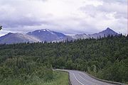
The George Parks Highway (numbered Interstate A-4 and Alaska Route 3), usually called simply the Parks Highway, runs 323 miles (520 km) from the Glenn Highway
35 miles (56 km) north of Anchorage
to Fairbanks
in the Alaska Interior
. The highway, originally known as the Anchorage-Fairbanks Highway, was completed in 1971, and given its current name in 1975.
 The highway, which mostly parallels the Alaska Railroad
, is one of the most important roads in Alaska. It is the main route between Anchorage and Fairbanks (Alaska's two largest metropolitan areas
), the principal access to Denali National Park and Preserve
and Denali State Park
, and the main highway in the Matanuska-Susitna Valley
.
It is a common misconception that the name "Parks Highway" comes from the road's proximity to the Denali state and national parks; it is in fact in honor of George Alexander Parks
, governor of the Territory of Alaska
from 1925 to 1933. However, the aptness of the name was recognized when it was chosen.
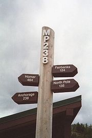
Mileposts along the Parks Highway do not begin with 0 (zero). Instead, they begin with Mile 35 (km 56), continuing the milepost numbering of the Glenn Highway
where the two highways intersect near Palmer
. The 0 (zero) mile marker
for the Glenn Highway
is at its terminus in downtown Anchorage
at the intersection of East 5th Avenue and Gambell Street. Thus mileposts along the Parks Highway reflect distance from Anchorage
, which is not actually on the Parks Highway.
There are two sections of the highway that are built to freeway standards. These include an area near the highway's intersection with the Glenn Highway
in Palmer and a stretch known as the Mitchell Expressway in Fairbanks leading to the highway's junction with the Richardson Highway
.
criticized Sarah Palin
for supporting the Knik Arm Bridge
, the Gravina Island Bridge
, and a road north out of Juneau instead of rebuilding the Parks Highway. However, the Ketchikan Daily News noted that, of the gubernatorial candidates, "Only Palin is consistent in support all of the projects".
Glenn Highway
-References:* Pasch, A. D., K. C. May. 2001. Taphonomy and paleoenvironment of hadrosaur from the Matanuska Formation in South-Central Alaska. In: Mesozioc Vertebrate Life. Ed.s Tanke, D. H., Carpenter, K., Skrepnick, M. W. Indiana University Press. Pages 219-236.-External links:**...
35 miles (56 km) north of Anchorage
Anchorage, Alaska
Anchorage is a unified home rule municipality in the southcentral part of the U.S. state of Alaska. It is the northernmost major city in the United States...
to Fairbanks
Fairbanks, Alaska
Fairbanks is a home rule city in and the borough seat of the Fairbanks North Star Borough in the U.S. state of Alaska.Fairbanks is the largest city in the Interior region of Alaska, and second largest in the state behind Anchorage...
in the Alaska Interior
Alaska Interior
The Alaska Interior covers most of the U.S. state's territory. It is largely wilderness. Mountains include Mount McKinley in the Alaska Range, the Wrangell Mountains, and the Ray Mountains....
. The highway, originally known as the Anchorage-Fairbanks Highway, was completed in 1971, and given its current name in 1975.
Alaska Railroad
The Alaska Railroad is a Class II railroad which extends from Seward and Whittier, in the south of the state of Alaska, in the United States, to Fairbanks , and beyond to Eielson Air Force Base and Fort Wainwright in the interior of that state...
, is one of the most important roads in Alaska. It is the main route between Anchorage and Fairbanks (Alaska's two largest metropolitan areas
Alaska census statistical areas
The United States Census Bureau has defined two Metropolitan Statistical Areas and three Micropolitan Statistical Areas for the State of Alaska. The following table describes these areas with the following information:...
), the principal access to Denali National Park and Preserve
Denali National Park and Preserve
Denali National Park and Preserve is located in Interior Alaska and contains Denali , the highest mountain in North America. The park and preserve together cover 9,492 mi² .The longest glacier is the Kalhiltna glacier....
and Denali State Park
Denali State Park
Denali State Park is a state park in the U.S. state of Alaska. It is located adjacent in the Matanuska-Susitna Borough to the east side of Denali National Park and Preserve, along the Parks Highway....
, and the main highway in the Matanuska-Susitna Valley
Matanuska-Susitna Valley
Matanuska-Susitna Valley is an area in Southcentral Alaska south of the Alaska Range about 35 miles north of Anchorage, Alaska....
.
It is a common misconception that the name "Parks Highway" comes from the road's proximity to the Denali state and national parks; it is in fact in honor of George Alexander Parks
George Alexander Parks
George Alexander Parks was an American engineer who worked in Alaska Territory for most of his career. Following an unexpected nomination from President Calvin Coolidge, he became the territory's first resident governor...
, governor of the Territory of Alaska
Alaska Territory
The Territory of Alaska was an organized incorporated territory of the United States that existed from August 24, 1912, until January 3, 1959, when it was admitted to the Union as the State of Alaska...
from 1925 to 1933. However, the aptness of the name was recognized when it was chosen.
Mileposts along the Parks Highway do not begin with 0 (zero). Instead, they begin with Mile 35 (km 56), continuing the milepost numbering of the Glenn Highway
Glenn Highway
-References:* Pasch, A. D., K. C. May. 2001. Taphonomy and paleoenvironment of hadrosaur from the Matanuska Formation in South-Central Alaska. In: Mesozioc Vertebrate Life. Ed.s Tanke, D. H., Carpenter, K., Skrepnick, M. W. Indiana University Press. Pages 219-236.-External links:**...
where the two highways intersect near Palmer
Palmer, Alaska
Palmer is the borough seat of the Matanuska-Susitna Borough in the state of Alaska, USA. It is part of the Anchorage Metropolitan Statistical Area. As of the 2010 census, the population of the city is 5,937....
. The 0 (zero) mile marker
Zero mile marker
Zero mile markers were markers where drivers could set their odometers to follow directions in early guide books.Also known as control stations or control points, the markers or landmarks were locations that allowed travelers to have a precise point to start the travel using directions in early...
for the Glenn Highway
Glenn Highway
-References:* Pasch, A. D., K. C. May. 2001. Taphonomy and paleoenvironment of hadrosaur from the Matanuska Formation in South-Central Alaska. In: Mesozioc Vertebrate Life. Ed.s Tanke, D. H., Carpenter, K., Skrepnick, M. W. Indiana University Press. Pages 219-236.-External links:**...
is at its terminus in downtown Anchorage
Anchorage, Alaska
Anchorage is a unified home rule municipality in the southcentral part of the U.S. state of Alaska. It is the northernmost major city in the United States...
at the intersection of East 5th Avenue and Gambell Street. Thus mileposts along the Parks Highway reflect distance from Anchorage
Anchorage, Alaska
Anchorage is a unified home rule municipality in the southcentral part of the U.S. state of Alaska. It is the northernmost major city in the United States...
, which is not actually on the Parks Highway.
There are two sections of the highway that are built to freeway standards. These include an area near the highway's intersection with the Glenn Highway
Glenn Highway
-References:* Pasch, A. D., K. C. May. 2001. Taphonomy and paleoenvironment of hadrosaur from the Matanuska Formation in South-Central Alaska. In: Mesozioc Vertebrate Life. Ed.s Tanke, D. H., Carpenter, K., Skrepnick, M. W. Indiana University Press. Pages 219-236.-External links:**...
in Palmer and a stretch known as the Mitchell Expressway in Fairbanks leading to the highway's junction with the Richardson Highway
Richardson Highway
The Richardson Highway is a highway in the U.S. state of Alaska, running 368 miles from Valdez to Fairbanks. It is marked as Alaska Route 4 from Valdez to Delta Junction and as Alaska Route 2 from there to Fairbanks. It is also connects segments of Alaska Route 1 between the Glenn Highway and the...
.
Controversy
Former Alaska governor Tony KnowlesTony Knowles (politician)
Anthony Carroll Knowles is an American Democratic politician and businessman who served as the seventh Governor of Alaska from December 1994 to December 2002. Barred from seeking a third consecutive term as governor in 2002, he ran unsuccessfully for Senate in 2004 and again for governor in...
criticized Sarah Palin
Sarah Palin
Sarah Louise Palin is an American politician, commentator and author. As the Republican Party nominee for Vice President in the 2008 presidential election, she was the first Alaskan on the national ticket of a major party and first Republican woman nominated for the vice-presidency.She was...
for supporting the Knik Arm Bridge
Knik Arm Bridge
The Knik Arm Bridge is a controversial proposed highway crossing of the Knik Arm portion of Cook Inlet, north of Anchorage, Alaska. The project has also been referred to as "Don Young's Way", after Alaskan Congressman Don Young who strongly supported the project when he was Chair of the House...
, the Gravina Island Bridge
Gravina Island Bridge
The Gravina Island Bridge, commonly referred to as the "Bridge to Nowhere", was a proposed bridge to replace the ferry that currently connects the town of Ketchikan, Alaska, with Gravina Island, an island which contains the Ketchikan International Airport as well as 50 residents. The bridge was...
, and a road north out of Juneau instead of rebuilding the Parks Highway. However, the Ketchikan Daily News noted that, of the gubernatorial candidates, "Only Palin is consistent in support all of the projects".
Exit list
Exits in Alaska are not numbered.| Milepost | Street | Notes |
|---|---|---|
| 35.0 | Traffic Is Directed Onto  Glenn Hwy South Glenn Hwy South |
|
| 35.0 | Glenn Hwy North |
Southbound Only |
| 35.92 | Matanuska Rd. | |
| 37.58 | N. Hyer Road | |
| 38.66 | Palmer Section Of Freeway Ends | |
| 352.65 | Fairbanks Section Of Freeway Begins | |
| 352.65 | Geist Road | |
| 353.81 | Airport Road | |
| Gap In Freeway | ||
| 354.73 | University Ave. South | |
| 356.94 | Peger Rd. | |
| 357.95 | Lathrop St. | |
| Freeway Resumes | ||
| 358.0 |  Steese Hwy N. Steese Hwy N. |
Northbound Only |
| 358.0 | Traffic Directed Onto Richardson Hwy S. |
|
Towns and places along the Parks Highway
- WasillaWasilla, AlaskaWasilla is a city in Matanuska-Susitna Borough, United States and the sixth-largest city in Alaska. It is located on the northern point of Cook Inlet in the Matanuska-Susitna Valley of the southcentral part of the state. The city's population was 7,831 at the 2010 census...
, mile 42 (km 68) - Big LakeBig Lake, AlaskaBig Lake is a census-designated place in Matanuska-Susitna Borough, Alaska, United States. It is part of the Anchorage, Alaska Metropolitan Statistical Area...
, via Big Lake Road, mile 52 (km 84) - HoustonHouston, AlaskaHouston is a city in Matanuska-Susitna Borough, Alaska, United States. It is part of the Anchorage, Alaska Metropolitan Statistical Area. The population was 1,202 at the 2000 census.-Geography:Houston is located at ....
, mile 57 (km 92) - WillowWillow, AlaskaWillow is a census-designated place in the Matanuska-Susitna Borough in the U.S. state of Alaska. It is part of the Anchorage, Alaska Metropolitan Statistical Area. At the 2000 census the population was 1,658.-History:...
, mile 69 (km 111) - Hatcher PassHatcher PassHatcher Pass is a mountain pass through the southwest part of the Talkeetna Mountains, Alaska. It is named after Robert Hatcher, a prospector and miner. The nearest incorporated communities are Palmer and Wasilla, approximately to the south, and Willow, approximately to the west...
, via Hatcher Pass Road, mile 71 (km 115) - TalkeetnaTalkeetna, AlaskaTalkeetna is a census-designated place in Matanuska-Susitna Borough, Alaska, United States. It is part of the Anchorage, Alaska Metropolitan Statistical Area. At the 2000 census the population was 772.-Geography:...
, via Talkeetna Spur Road, mile 99 (km 159) - Trapper CreekTrapper Creek, AlaskaTrapper Creek is a census-designated place in Matanuska-Susitna Borough, Alaska, United States. It is part of the Anchorage, Alaska Metropolitan Statistical Area and is known as the southern gateway to Denali State Park...
, mile 115 (km 185) - Denali State ParkDenali State ParkDenali State Park is a state park in the U.S. state of Alaska. It is located adjacent in the Matanuska-Susitna Borough to the east side of Denali National Park and Preserve, along the Parks Highway....
, miles 132–169 (km 212–272) - CantwellCantwell, AlaskaCantwell was a railway flag stop at the junction with the Denali Highway. The original town is off the Parks Highway. It is a census-designated place in Denali Borough, Alaska, United States...
, mile 210 (km 338) - Denali National ParkDenali National Park and PreserveDenali National Park and Preserve is located in Interior Alaska and contains Denali , the highest mountain in North America. The park and preserve together cover 9,492 mi² .The longest glacier is the Kalhiltna glacier....
entrance, mile 237 (km 382) - HealyHealy, AlaskaHealy is a census-designated place in and the borough seat of Denali Borough in the U.S. state of Alaska. The population was 971 at the 2007 census.-Geography:Healy is located at ....
, mile 249 (km 400) - AndersonAnderson, AlaskaAnderson is a city in Denali Borough, Alaska, United States. At the 2000 census the population was 367. The city is named after one of the original homesteaders.- History :...
and Clear Air Force StationClear Air Force StationClear Air Force Station is a United States Air Force Station located 5 miles south of Anderson, Alaska, USA, northeast of Mount McKinley, and southwest of Fairbanks. Its primary mission is to detect incoming ICBMs and submarine-launched ballistic missiles.-Overview:Clear AFS is operated by the...
, mile 284 (km 456) - NenanaNenana, AlaskaNenana is a Home Rule City in the Yukon-Koyukuk Census Area of the Unorganized Borough of the U.S. state of Alaska. Nenana lies at the juncture of the Nenana River and the Tanana River. The population was 402 at the 2000 census. "Nenana" means 'a good place to camp between two rivers.'-History...
, mile 304 (km 490) - EsterEster, AlaskaEster is a census-designated place in Fairbanks North Star Borough, Alaska, United States. It is part of the 'Fairbanks, Alaska Metropolitan Statistical Area'. The population was 2,422 at the 2010 census...
, mile 352 (km 566) - FairbanksFairbanks, AlaskaFairbanks is a home rule city in and the borough seat of the Fairbanks North Star Borough in the U.S. state of Alaska.Fairbanks is the largest city in the Interior region of Alaska, and second largest in the state behind Anchorage...
, mile 358 (km 576)