
De Beauvoir Town
Encyclopedia
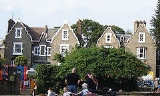
De Beauvoir Town is a district of the London Borough of Hackney
that partly falls within the London Borough of Islington
. Its borders are Kingsland Road
in the east, Southgate Road to the west, the Regent's Canal in the south and Tottenham Road to the north. These are the official borders; however, some residents to the west of Southgate Road
in the London Borough of Islington
also consider themselves to be within this highly desirable area of central north London.
It shares the northern London postal district of N1 with neighbouring Islington
, Barnsbury
, Canonbury
and Hoxton
.
the previous year, developer William Rhodes secured a lease
for 150 acre (0.607029 km²) of land from Peter de Beauvoir. Rhodes planned to build residences for the upper class
es in a grid pattern, with four squares on diagonal streets intersecting at an octagon. However, work stopped in 1823 when Rhodes was found to have obtained his lease unfairly and after a court case spanning over 20 years the land reverted to the de Beauvoir family in 1834.
The delay in building had meant that Rhodes' clientele had since moved on to the new suburbs of the West End. The scheme was scaled down and of the planned squares only the southeastern was built, as De Beauvoir Square, although the diagonals partly survived in Enfield Road, Stamford Road and Ardleigh Road. Occupied in the 1840s by the newly emerging middle class
es, the estate was almost wholly residential except around Kingsland Basin
and the south-west corner where a factory was leased from 1823.
 In 1937, due to its easy access to Kingsland Basin, the south-east corner between Downham Road and Hertford Road was re-zoned for industrial use. Soon after all the area south of Downham Road was included. This distinguished it from the north side of Downham Road, which was already zoned for business and acted as a buffer for the mainly residential streets beyond. In 1938 De Beauvoir Crescent was suggested as another business zone to protect housing to the north.
In the early 1960s the northern part of De Beauvoir Town between Buckingham Road and Tottenham Road was rebuilt as the Metropolitan Borough of Hackney
's Kingsgate estate. In the late 1960s a larger area west of the canal basin, which contained many small factories, made way for the De Beauvoir Estate. The east side of De Beauvoir Square was also lost to the Lockner Road estate. In 1968 the De Beauvoir Town association was formed. The rest of the square with the area bounded by Englefield Road, Northchurch Road, Southgate Road, Hertford Road, and Stamford Road became a conservation area in 1969. This area was later extended to cover most of De Beauvoir Town; the eastern edge, however, is in the Kingsland conservation area.
, the poet, the son of naturalist Philip Henry Gosse
De Beauvoir Town was home to William Lyttle (1931–2010), a retired electrical engineer known as the Mole Man of Hackney. Mr Lyttle dug a series of tunnels under his property on the corner of Mortimer Road and Stamford Road. In 2001, his tunnelling caused an 8 ft (2.4 m) hole to appear in the pavement on Stamford Road. Reports that the tunnelling had started again in 2006 were confirmed when Hackney Council found a web of tunnels and caverns, some 8 m (26 ft) deep, spreading up to 20m in every direction from his house. In August 2006, the Council succeeded in getting a court order banning Mr Lyttle from his property. Mr Lyttle died in 2010 and the fate of the house, now derelict and needing a new roof, is uncertain.
. Local councillors for De Beauvoir ward
are Rob Chapman, Tom Ebbutt and Gulay Icoz.
 Nearest railway stations
The nearest London Overground
station is Dalston Kingsland
, on the TFL London Overground line. In 2010, the East London Line - part of the TFL London Overground network re-opened, with stations at Dalston Junction
and Haggerston
. Essex Road, part of the National Rail
network on the Northern City Line
is to the north-west of the district.
There is no local London Underground station but about 20 minutes walk away, the nearest are Angel
- Two stops east of Dalston kingsland, Highbury & Islington and Old Street.
Nearby bus routes
The area is well served by buses
.
, and to the west, Islington
.
London Borough of Hackney
The London Borough of Hackney is a London borough of North/North East London, and forms part of inner London. The local authority is Hackney London Borough Council....
that partly falls within the London Borough of Islington
London Borough of Islington
The London Borough of Islington is a London borough in Inner London. It was formed in 1965 by merging the former metropolitan boroughs of Islington and Finsbury. The borough contains two Westminster parliamentary constituencies, Islington North and Islington South & Finsbury...
. Its borders are Kingsland Road
Kingsland Road
Kingsland Road is the name of a road, part of the A10, in the London Borough of Hackney in England. It runs from the junction with Old Street and Hackney Road north to the junction with Balls Pond Road and Dalston Lane, where it changes its name to Kingsland High Street...
in the east, Southgate Road to the west, the Regent's Canal in the south and Tottenham Road to the north. These are the official borders; however, some residents to the west of Southgate Road
Southgate Road
Southgate Road is a street that runs from Baring Street in the south to the junction with Mildmay Park and Ball's Pond Road in the north. The street forms a part of the B102 road, leading from Newington Green to The City. The west side of Southgate Road is in the London Borough of Islington; and...
in the London Borough of Islington
London Borough of Islington
The London Borough of Islington is a London borough in Inner London. It was formed in 1965 by merging the former metropolitan boroughs of Islington and Finsbury. The borough contains two Westminster parliamentary constituencies, Islington North and Islington South & Finsbury...
also consider themselves to be within this highly desirable area of central north London.
It shares the northern London postal district of N1 with neighbouring Islington
Islington
Islington is a neighbourhood in Greater London, England and forms the central district of the London Borough of Islington. It is a district of Inner London, spanning from Islington High Street to Highbury Fields, encompassing the area around the busy Upper Street...
, Barnsbury
Barnsbury
Barnsbury is an area of north London in the London Borough of Islington, in the N1 postal districts.The name is a corruption of villa de Iseldon Berners , being so called after the Berners family: powerful medieval manorial lords who gained ownership of a large part of Islington after the Norman...
, Canonbury
Canonbury
Canonbury is a residential district in the London Borough of Islington in the north of London. It is roughly in the area between Essex Road, Upper Street and Cross Street and either side of St Paul's Road....
and Hoxton
Hoxton
Hoxton is an area in the London Borough of Hackney, immediately north of the financial district of the City of London. The area of Hoxton is bordered by Regent's Canal on the north side, Wharf Road and City Road on the west, Old Street on the south, and Kingsland Road on the east.Hoxton is also a...
.
19th century
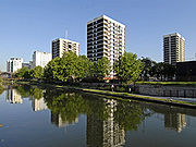
Until 1820 the area now covered by De Beauvoir Town was open country with a few grand houses. In 1821, stimulated by the opening of the Regent's CanalRegent's Canal
Regent's Canal is a canal across an area just north of central London, England. It provides a link from the Paddington arm of the Grand Union Canal, just north-west of Paddington Basin in the west, to the Limehouse Basin and the River Thames in east London....
the previous year, developer William Rhodes secured a lease
Lease
A lease is a contractual arrangement calling for the lessee to pay the lessor for use of an asset. A rental agreement is a lease in which the asset is tangible property...
for 150 acre (0.607029 km²) of land from Peter de Beauvoir. Rhodes planned to build residences for the upper class
Upper class
In social science, the "upper class" is the group of people at the top of a social hierarchy. Members of an upper class may have great power over the allocation of resources and governmental policy in their area.- Historical meaning :...
es in a grid pattern, with four squares on diagonal streets intersecting at an octagon. However, work stopped in 1823 when Rhodes was found to have obtained his lease unfairly and after a court case spanning over 20 years the land reverted to the de Beauvoir family in 1834.
The delay in building had meant that Rhodes' clientele had since moved on to the new suburbs of the West End. The scheme was scaled down and of the planned squares only the southeastern was built, as De Beauvoir Square, although the diagonals partly survived in Enfield Road, Stamford Road and Ardleigh Road. Occupied in the 1840s by the newly emerging middle class
Middle class
The middle class is any class of people in the middle of a societal hierarchy. In Weberian socio-economic terms, the middle class is the broad group of people in contemporary society who fall socio-economically between the working class and upper class....
es, the estate was almost wholly residential except around Kingsland Basin
Kingsland Basin
Kingsland Basin is a canal basin in Kingsland, London, part of the London Borough of Hackney. The basin is located off the Regents Canal.The basin is a site of planned redevelopment.-See also:*Canals of the United Kingdom...
and the south-west corner where a factory was leased from 1823.
20th Century
In the early 1960s the northern part of De Beauvoir Town between Buckingham Road and Tottenham Road was rebuilt as the Metropolitan Borough of Hackney
Metropolitan Borough of Hackney
The Metropolitan Borough of Hackney was a Metropolitan borough of the County of London from 1900 to 1965. Its area became part of the London Borough of Hackney.-Formation and boundaries:...
's Kingsgate estate. In the late 1960s a larger area west of the canal basin, which contained many small factories, made way for the De Beauvoir Estate. The east side of De Beauvoir Square was also lost to the Lockner Road estate. In 1968 the De Beauvoir Town association was formed. The rest of the square with the area bounded by Englefield Road, Northchurch Road, Southgate Road, Hertford Road, and Stamford Road became a conservation area in 1969. This area was later extended to cover most of De Beauvoir Town; the eastern edge, however, is in the Kingsland conservation area.
Notable residents
Edmund GosseEdmund Gosse
Sir Edmund William Gosse CB was an English poet, author and critic; the son of Philip Henry Gosse and Emily Bowes.-Early life:...
, the poet, the son of naturalist Philip Henry Gosse
Philip Henry Gosse
Philip Henry Gosse was an English naturalist and popularizer of natural science, virtually the inventor of the seawater aquarium, and a painstaking innovator in the study of marine biology...
De Beauvoir Town was home to William Lyttle (1931–2010), a retired electrical engineer known as the Mole Man of Hackney. Mr Lyttle dug a series of tunnels under his property on the corner of Mortimer Road and Stamford Road. In 2001, his tunnelling caused an 8 ft (2.4 m) hole to appear in the pavement on Stamford Road. Reports that the tunnelling had started again in 2006 were confirmed when Hackney Council found a web of tunnels and caverns, some 8 m (26 ft) deep, spreading up to 20m in every direction from his house. In August 2006, the Council succeeded in getting a court order banning Mr Lyttle from his property. Mr Lyttle died in 2010 and the fate of the house, now derelict and needing a new roof, is uncertain.
Elected representatives
The local MP is Meg HillierMeg Hillier
Margaret Olivia Hillier is a British Labour Co-operative politician who has been the Member of Parliament for Hackney South and Shoreditch since 2005, and was a junior Minister in HM Government from 2007 to 2010...
. Local councillors for De Beauvoir ward
De Beauvoir (ward)
De Beauvoir is a ward in the London Borough of Hackney and forms part of the Hackney South and Shoreditch constituency.The ward returns three councillors to Borough Council, with an election every four years. At the last election on 6 May 2010, Rob Chapman, Gulay Icoz, and Tom Ebbutt, all Labour...
are Rob Chapman, Tom Ebbutt and Gulay Icoz.
Education
Transport and locale
The nearest London Overground
London Overground
London Overground is a suburban rail network in London and Hertfordshire. It has been operated by London Overground Rail Operations since 2007 as part of the National Rail network, under the franchise control and branding of Transport for London...
station is Dalston Kingsland
Dalston Kingsland railway station
Dalston Kingsland railway station is a railway station on the North London Line in London, England. It is in the Dalston area of the London Borough of Hackney, on the western side of Kingsland High Street and opposite Ridley Road Market. The station and all trains serving it are operated by London...
, on the TFL London Overground line. In 2010, the East London Line - part of the TFL London Overground network re-opened, with stations at Dalston Junction
Dalston Junction railway station
Dalston Junction railway station is in the Dalston area of the London Borough of Hackney at the crossroad of Dalston Lane, Kingsland Road and Balls Pond Road...
and Haggerston
Haggerston railway station
Haggerston railway station is in the London Borough of Hackney, in London. The station is located on the Kingsland Viaduct in the Haggerston district at the junction of Arbutus Street and Frederick Terrace, near Kingsland Road. The main entrance is in Lee Street...
. Essex Road, part of the National Rail
National Rail
National Rail is a title used by the Association of Train Operating Companies as a generic term to define the passenger rail services operated in Great Britain...
network on the Northern City Line
Northern City Line
The Northern City Line is a railway line from Moorgate to Finsbury Park in London, once part of the Great Northern Electrics line. It should not be confused with the City branch of the Northern line, nor with the North London Line...
is to the north-west of the district.
There is no local London Underground station but about 20 minutes walk away, the nearest are Angel
Angel tube station
Angel tube station is a London Underground station in The Angel, Islington. It is on the Bank branch of the Northern Line, between Old Street and King's Cross St. Pancras stations. It is in Travelcard Zone 1. The tube stop serves as a portal to several Off West End, or fringe theatre, venues,...
- Two stops east of Dalston kingsland, Highbury & Islington and Old Street.
Nearby bus routes
The area is well served by buses
London Buses
London Buses is the subsidiary of Transport for London that manages bus services within Greater London, UK. Buses are required to carry similar red colour schemes and conform to the same fare scheme...
.
- 21 (Newington Green - Lewisham)
- 30London Buses route 30London Buses route 30 is a Transport for London contracted bus route in London, United Kingdom. The service is currently contracted to First Capital.-History:Route 30 commenced operation on 8 May 1911 between Kings Cross and Fulham Cross...
(Marble Arch - Hackney Wick) - 38/N38 (Victoria - Clapton)
- 43London Buses route 43London Buses route 43 is a Transport for London contracted bus route in London, United Kingdom. The service is currently contracted to Metroline.-History:...
(Friern Barnet - London Bridge Station) - 56 (Smithfield - Whipps Cross)
- 67 (Aldgate - Wood Green)
- 73/N73 (Victoria - Seven Sisters)
- 76/N76 (Waterloo - Seven Sisters)
- 141 (London Bridge - Palmers Green)
- 149 (London Bridge - Edmonton Green)
- 242 (Tottenham Court Road - Homerton Hospital)
- 243/N243 (Waterloo - Wood Green)
- 277 (Highbury & Islington - Leamouth)
- 341 (Waterloo - Northumberland Park)
- 476 (Euston - Northumberland Park)
Walking and cycling
The Regents Canal towpath is easily accessible to pedestrians and cyclists. Travelling east, provides access to Victoria ParkVictoria Park, East London
Victoria Park is 86.18 hectares of open space that stretches out across part of the East End of London, England bordering parts of Bethnal Green, Hackney, and Bow, such as along Old Ford Road, London E3 and Victoria Park Road E9. The park is entirely within the London Borough of Tower Hamlets...
, and to the west, Islington
Islington
Islington is a neighbourhood in Greater London, England and forms the central district of the London Borough of Islington. It is a district of Inner London, spanning from Islington High Street to Highbury Fields, encompassing the area around the busy Upper Street...
.
External links
- 28 Weeks Later filmed in De Beauvoir Hackney Today Issue 158, 7 May 2007.
- Projects Filmed in De Beauvoir
- Brickfields: Georgian landscape (Building Exploratory, n.d.)
- The De Beauvoir Association (includes further information and image of William Rhodes' original plans)