
States of Sudan
Encyclopedia
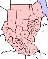
Below is a list of the 15 states of Sudan
, organized by their original provinces during the period of Anglo-Egyptian Sudan
. Arabic language
versions are, as appropriate, in parentheses. States that were not provinces before 1994 are marked with (*). Transliterations from Arabic to English
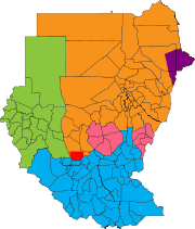
may vary; in particular, the article "al" is sometimes transliterated as "el". Numbers correspond to those of the map at right. Prior to 9 July 2011, the Republic of Sudan was composed of 25 states. The ten southern states now form part of the independent nation of the Republic of South Sudan.
 Anglo-Egyptian Sudan
had eight mudiriya
t, or province
s, which were ambiguous when created but became well defined by the beginning of the Second World War. The eight provinces were: Blue Nile
, Darfur
, Equatoria
, Kassala
, Khartoum
, Kurdufan
, Northern
, and Upper Nile. In 1948 Bahr al Ghazal split from Equatoria.
There were numerous new provinces created on 1 July 1973. North
and South Darfur
were created from Darfur, while Kurdufan divided into North
and South Kurdufan
. Al Jazirah and White Nile were split off from Blue Nile. River Nile split off from Northern. Red Sea was split off from Kassala.
A further fracturing of provinces occurred in 1976. Lakes split from Bahr al Ghazal, and Jonglei
split off from Upper Nile. Equatoria divided into East and Western Equatoria. There were thus eighteen provinces. In 1991, the government reorganized the administrative regions into nine federal states, matching the nine provinces that had existed from 1948 to 1973. On 14 February 1994, the government reorganized yet again, creating twenty-six wilayat (states). The majority of the wilayat were either the old provinces or administrative subregions of a province. As part of the new government structure in South Sudan
in 2005, Bahr al Jabal was renamed Central Equatoria
. In 2006, West Kurdufan was split and merged with North Kurdufan and South Kurdufan.
became the independent nation of South Sudan
. They were further divided into 86 counties
.
Sudan
Sudan , officially the Republic of the Sudan , is a country in North Africa, sometimes considered part of the Middle East politically. It is bordered by Egypt to the north, the Red Sea to the northeast, Eritrea and Ethiopia to the east, South Sudan to the south, the Central African Republic to the...
, organized by their original provinces during the period of Anglo-Egyptian Sudan
Anglo-Egyptian Sudan
Anglo-Egyptian Sudan referred to the manner by which Sudan was administered between 1899 and 1956, when it was a condominium of Egypt and the United Kingdom.-Union with Egypt:...
. Arabic language
Arabic language
Arabic is a name applied to the descendants of the Classical Arabic language of the 6th century AD, used most prominently in the Quran, the Islamic Holy Book...
versions are, as appropriate, in parentheses. States that were not provinces before 1994 are marked with (*). Transliterations from Arabic to English
English language
English is a West Germanic language that arose in the Anglo-Saxon kingdoms of England and spread into what was to become south-east Scotland under the influence of the Anglian medieval kingdom of Northumbria...
may vary; in particular, the article "al" is sometimes transliterated as "el". Numbers correspond to those of the map at right. Prior to 9 July 2011, the Republic of Sudan was composed of 25 states. The ten southern states now form part of the independent nation of the Republic of South Sudan.
States of the Republic of Sudan
The following 15 states form the territory of the Republic of Sudan.- Blue Nile
- Al Jazirah (7)
- Blue Nile (An Nil al Azraq) (24)
- SennarSennar (state)Sennar is one of the 15 wilayat or states of Sudan. It has an area of 37,844 km² and an estimated population of approximately 1,100,000 . Singa is the capital of Sennar State. Another significant town is Sennar , largest city in the state...
(*) (25) - White Nile (An Nil al Abyad) (8)
- DarfurDarfurDarfur is a region in western Sudan. An independent sultanate for several hundred years, it was incorporated into Sudan by Anglo-Egyptian forces in 1916. The region is divided into three federal states: West Darfur, South Darfur, and North Darfur...
(A Transitional Darfur Regional AuthorityTransitional Darfur Regional AuthorityThe Darfur Regional Authority is an interim governing body for the Darfur region of the Republic of Sudan. It was established as the Transitional Darfur Regional Authority in April 2007 under the terms of the 2006 Darfur Peace Agreement signed in May 2006.The Transitional Darfur Regional...
also exists)- North DarfurNorth DarfurNorth Darfur is one of the 15 wilayat or states of Sudan. It is one of the three states composing the Darfur region. It has an area of 296,420 km² and an estimated population of approximately 1,583,000 . Al-Fashir is the capital of the state...
(Shamal Darfur) (2) - South DarfurSouth DarfurSouth Darfur is one of the 15 wilayat or states of Sudan. It is one of the three states that compose the region of Darfur in western Sudan. It has an area of and an estimated population of approximately 2,890,000 . Nyala is the capital of the state. The State was affected by the 2010 Sahel...
(Janub Darfur) (11) - West DarfurWest DarfurWest Darfur is one of the 15 states of Sudan, and one of three comprising the Darfur region. It has an area of 79,460 km² and an estimated population of approximately 1,007,000 . It borders North and South Darfur to the east. The Chadian prefectures of Biltine and Ouaddaï lie to the west,...
(Gharb Darfur) (12)
- North Darfur
- Kassala (An Eastern Sudan States Coordinating CouncilEastern Sudan States Coordinating CouncilThe Eastern Sudan States Coordinating Council is a body established by the Eastern Sudan Peace Agreement signed by the Government of Sudan and the rebel Eastern Front in June 2006. It seeks to enhance cooperation between the three eastern states of the Republic of Sudan; Kassala, Red Sea and Al...
also exists)- KassalaKassala (state)Kassala is one of the 15 wilayat of Sudan. It has an area of 36,710 km² and an estimated population of approximately 1,400,000 . Kassala is the capital of the state; other towns in Kassala include Aroma, Hamishkoreb, and Khor Telkok....
(Ash Sharqiyah) (5) - Al QadarifAl Qadarif (state)Al Qadarif , also spelt Gadaref or Gadarif, is one of the 15 wilayat or states of Sudan. It has an area of 75,263 km² and an estimated population of approximately 1,400,000 . Al Qadarif is the capital of the state; other towns include Doka and Gallabat....
(6) - Red Sea (Al Bahr al Ahmar) (26)
- Kassala
- Khartoum
- KhartoumKhartoum (state)Khartoum is one of the 15 states of Sudan. It has an area of 22,122 km2 and an estimated population of approximately 7,152,102 . Khartoum, the national capital of Sudan, is the capital of the Khartoum State....
(Al Khartum) (3)
- Khartoum
- KurdufanKurdufanKurdufan , also spelled Kordofan, is a former province of central Sudan. In 1994 it was divided into three new federal states: North Kurdufan, South Kurdufan, and West Kurdufan...
- North KurdufanNorth KurdufanNorth Kurdufan is one of the 15 wilayat or states of Sudan. It has an area of 185,302 km² and an estimated population of 2,529,370 . Al-Ubayyid is the capital of the state.North Kurdufan is generally arid and desert.- History :...
(Shamal Kurdufan) (9) - South KurdufanSouth KurdufanSouthern Kordofan is one of the 15 wilayat or provinces of Sudan. It has an area of 158,355 km² and an estimated population of approximately 1,100,000 people . Kaduqli is the capital of the state...
(Janub Kurdufan) (13)
- North Kurdufan
- Northern
- NorthernNorthern, SudanNorthern is one of the 15 wilayat or states of Sudan. It has an area of 348,765 km² and an estimated population of 833,743 . Dongola is the capital of the state. The town of Wadi Halfa, a headquarters of the British in the late nineteenth century, is located in the north of the province....
(Ash Shamaliyah) (1) - River Nile (Nahr an Nil) (4)
- Northern
History
Anglo-Egyptian Sudan
Anglo-Egyptian Sudan referred to the manner by which Sudan was administered between 1899 and 1956, when it was a condominium of Egypt and the United Kingdom.-Union with Egypt:...
had eight mudiriya
Mudiriya
Mudiriya , meaning "directorate" , is an administrative subdivision also known in English as mudirate, and often translated as "province". It was formerly used in Egypt and in Anglo-Egyptian Sudan. The term was also used in Yemen. The mudiriya were subdivided into markaz, or districts...
t, or province
Province
A province is a territorial unit, almost always an administrative division, within a country or state.-Etymology:The English word "province" is attested since about 1330 and derives from the 13th-century Old French "province," which itself comes from the Latin word "provincia," which referred to...
s, which were ambiguous when created but became well defined by the beginning of the Second World War. The eight provinces were: Blue Nile
Blue Nile
The Blue Nile is a river originating at Lake Tana in Ethiopia. With the White Nile, the river is one of the two major tributaries of the Nile...
, Darfur
Darfur
Darfur is a region in western Sudan. An independent sultanate for several hundred years, it was incorporated into Sudan by Anglo-Egyptian forces in 1916. The region is divided into three federal states: West Darfur, South Darfur, and North Darfur...
, Equatoria
Equatoria
Equatoria is a region in the south of present-day South Sudan along the upper reaches of the White Nile. Originally a province of Egypt, it also contained most of Northern part of present day Uganda including Albert Lake...
, Kassala
Kassala (state)
Kassala is one of the 15 wilayat of Sudan. It has an area of 36,710 km² and an estimated population of approximately 1,400,000 . Kassala is the capital of the state; other towns in Kassala include Aroma, Hamishkoreb, and Khor Telkok....
, Khartoum
Khartoum (state)
Khartoum is one of the 15 states of Sudan. It has an area of 22,122 km2 and an estimated population of approximately 7,152,102 . Khartoum, the national capital of Sudan, is the capital of the Khartoum State....
, Kurdufan
Kurdufan
Kurdufan , also spelled Kordofan, is a former province of central Sudan. In 1994 it was divided into three new federal states: North Kurdufan, South Kurdufan, and West Kurdufan...
, Northern
Northern, Sudan
Northern is one of the 15 wilayat or states of Sudan. It has an area of 348,765 km² and an estimated population of 833,743 . Dongola is the capital of the state. The town of Wadi Halfa, a headquarters of the British in the late nineteenth century, is located in the north of the province....
, and Upper Nile. In 1948 Bahr al Ghazal split from Equatoria.
There were numerous new provinces created on 1 July 1973. North
North Darfur
North Darfur is one of the 15 wilayat or states of Sudan. It is one of the three states composing the Darfur region. It has an area of 296,420 km² and an estimated population of approximately 1,583,000 . Al-Fashir is the capital of the state...
and South Darfur
South Darfur
South Darfur is one of the 15 wilayat or states of Sudan. It is one of the three states that compose the region of Darfur in western Sudan. It has an area of and an estimated population of approximately 2,890,000 . Nyala is the capital of the state. The State was affected by the 2010 Sahel...
were created from Darfur, while Kurdufan divided into North
North Kurdufan
North Kurdufan is one of the 15 wilayat or states of Sudan. It has an area of 185,302 km² and an estimated population of 2,529,370 . Al-Ubayyid is the capital of the state.North Kurdufan is generally arid and desert.- History :...
and South Kurdufan
South Kurdufan
Southern Kordofan is one of the 15 wilayat or provinces of Sudan. It has an area of 158,355 km² and an estimated population of approximately 1,100,000 people . Kaduqli is the capital of the state...
. Al Jazirah and White Nile were split off from Blue Nile. River Nile split off from Northern. Red Sea was split off from Kassala.
A further fracturing of provinces occurred in 1976. Lakes split from Bahr al Ghazal, and Jonglei
Jonglei
Jonglei is one of the 10 states of South Sudan. Jonglei is the largest state in the Republic of South Sudan, with approximately 122,479 km2, as well as the most populous according to the controversial 2008 census conducted during present-day South Sudan's second period of autonomy. Bor is the...
split off from Upper Nile. Equatoria divided into East and Western Equatoria. There were thus eighteen provinces. In 1991, the government reorganized the administrative regions into nine federal states, matching the nine provinces that had existed from 1948 to 1973. On 14 February 1994, the government reorganized yet again, creating twenty-six wilayat (states). The majority of the wilayat were either the old provinces or administrative subregions of a province. As part of the new government structure in South Sudan
South Sudan
South Sudan , officially the Republic of South Sudan, is a landlocked country located in the Sahel region of northeastern Africa. It is also part of the North Africa UN sub-region. Its current capital is Juba, which is also its largest city; the capital city is planned to be moved to the more...
in 2005, Bahr al Jabal was renamed Central Equatoria
Central Equatoria
-Government:Executive*Governor - Maj. Gen. Clement Wani Konga*Deputy Governor and Minister of Education, Science and Technology - Mr. Manase Lomole Waya *Minister of Education - Lokulenge Lole Lokule...
. In 2006, West Kurdufan was split and merged with North Kurdufan and South Kurdufan.
Former states now part of South Sudan
On 9 July 2011 the ten southern statesStates of Southern Sudan
South Sudan is divided into 10 states, which were created out of the three historic provinces of Bahr el Ghazal, Equatoria and Greater Upper Nile. They are further divided into 86 counties.-Bahr el Ghazal:...
became the independent nation of South Sudan
South Sudan
South Sudan , officially the Republic of South Sudan, is a landlocked country located in the Sahel region of northeastern Africa. It is also part of the North Africa UN sub-region. Its current capital is Juba, which is also its largest city; the capital city is planned to be moved to the more...
. They were further divided into 86 counties
Counties of South Sudan
The ten states of the East African country of South Sudan are divided into 86 counties. The ten states are Central Equatoria, Eastern Equatoria, Jonglei, Lakes, Northern Bahr el Ghazal, Unity, Upper Nile, Warrap, Western Bahr el Ghazal, and Western Equatoria....
.