

D23 (Croatia)
Encyclopedia
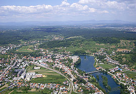
Duga Resa
Duga Resa is a town in Karlovac County, Croatia. It is located east of Rijeka.-Name:The earliest reference to Duga Resa is from the year 1380...
, Josipdol
Josipdol
Josipdol is a village and municipality in Karlovac County, Croatia. The municipality is part of Lika.-Geography:Josipdol is situated in the Ogulin-Plaški valley which together with Lika and Gorski Kotar forms Mountainous Croatia. The town is located at the crossroads of state roads D-23, which...
and Senj
Senj
Senj , German Zengg, Hungarian Zeng and Italian Segna) is the oldest town on the upper Adriatic, and it was founded in the time before the Romans some 3000 years ago on the hill Kuk. It was the center of the Illyrian tribe Iapydes. The current settlement is situated at the foot of the slopes Mala...
, to the state road network of Croatia, and most notably to A1 motorway
A1 (Croatia)
The A1 motorway is the longest motorway in Croatia spanning . As it connects Zagreb, the nation's capital, to Split, the second largest city in the country and the largest city in Dalmatia, the motorway represents a major north–south transportation corridor in Croatia and a significant part of the...
in Žuta Lokva
Žuta Lokva
Žuta Lokva is a village in Croatia....
interchange, as well as two major state roads - D3
D3 (Croatia)
D3 is a state road in western parts of Croatia connecting Rijeka on the Adriatic coast to Zagreb, Karlovac and Varaždin, as well as to Goričan border crossing to Hungary...
and D8
D8 (Croatia)
D8 state road comprises Croatian section of Adriatic Highway, and it runs from Pasjak border crossing to Slovenia via Rijeka, Senj, Zadar, Šibenik, Split, Opuzen and Dubrovnik to the border with Montenegro at Karasovići. Most of the D8 state road is still a two-lane road, excepting rare four-lane...
, located at the northern terminus and the southern terminus of the road respectively. The road is 104.9 km (65.2 mi) long. The route comprises a significant number of urban intersections, in segments of the road running through Duga Resa and Senj.
The D23 state road runs parallel to a section of the A1 motorway between Karlovac
Karlovac
Karlovac is a city and municipality in central Croatia. The city proper has a population of 49,082, while the municipality has a population of 59,395 inhabitants .Karlovac is the administrative centre of Karlovac County...
and Žuta Lokva
Žuta Lokva
Žuta Lokva is a village in Croatia....
interchanges, thus serving as an alternate or backup route for the motorway. Additionally, A7 motorway
A7 (Croatia)
The A7 motorway is a long motorway in Croatia. It connects the nation's largest port in Rijeka, to the Croatian motorway network, as well as to the Rupa and Pasjak border crossings to Slovenia. The motorway forms part of a longitudinal transportation corridor in Croatia, and it is a part of...
route is planned along the D23 road between Senj
Senj
Senj , German Zengg, Hungarian Zeng and Italian Segna) is the oldest town on the upper Adriatic, and it was founded in the time before the Romans some 3000 years ago on the hill Kuk. It was the center of the Illyrian tribe Iapydes. The current settlement is situated at the foot of the slopes Mala...
and Žuta Lokva. Once that motorway is completed, the D23 road shall run parallel to either A1 or A7 motorway along its entire length.
The road, as well as all other state roads in Croatia, is managed and maintained by Hrvatske ceste
Hrvatske ceste
Hrvatske ceste is a Croatian state-owned company pursuant to provisions of the Croatian Public Roads Act , the county and local roads are managed by county authorities, while the motorways are managed by Croatian Motorways Ltd and other concessionaires.The company is currently administered by a...
, a state-owned company.
History
Vratnik pass, currently a part of the D23 road, was already in use during Roman time as a salt roadSalt Road
A salt road ) is any of the prehistoric and historical trade routes by which essential salt has been transported to regions that lacked it ....
, and it became important for timber and other goods in the Middle Ages. However, the first well documented road built along the route was Via Josephina named after Joseph II, Holy Roman Emperor
Joseph II, Holy Roman Emperor
Joseph II was Holy Roman Emperor from 1765 to 1790 and ruler of the Habsburg lands from 1780 to 1790. He was the eldest son of Empress Maria Theresa and her husband, Francis I...
who commissioned its construction in 1775. Latin inscriptions carved in rock along the original Via Josephina route completed in 1779 testify that the Emperor travelled through the Vratnik pass on horseback when he realized that the route between Senj
Senj
Senj , German Zengg, Hungarian Zeng and Italian Segna) is the oldest town on the upper Adriatic, and it was founded in the time before the Romans some 3000 years ago on the hill Kuk. It was the center of the Illyrian tribe Iapydes. The current settlement is situated at the foot of the slopes Mala...
, as a major fortress on Adriatic coast, and the hinterland was nearly impassable. Legend has it that this happened when he fell from his horse near Vratnik Pass. Even though the incident is impossible to verify, the town of Josipdol
Josipdol
Josipdol is a village and municipality in Karlovac County, Croatia. The municipality is part of Lika.-Geography:Josipdol is situated in the Ogulin-Plaški valley which together with Lika and Gorski Kotar forms Mountainous Croatia. The town is located at the crossroads of state roads D-23, which...
to the east of the mountain pass is named after the Holy Roman Emperor.
In 1775, Joseph II indeed commissioned construction of the route, exactly 100 km (62.1 mi) long, from Vinko Struppi, a military engineer, and the road, named after the Emperor, was completed in 1779. The original route comprised very steep sections and 20% inclines were not uncommon. There was even one climb at a 30% grade. Because of this the road was modified and extended by 15 km (9.3 mi), in order to remove such steep sections. The first reconstruction was carried out as early as late 18th century, and another one between 1833 and 1845 managed by Field Marshal Josef Philipp Vukassovich
Josef Philipp Vukassovich
Josef Philipp von Vukassovich , also Josef Wukassovitch, was a Croatian soldier who joined the army of Habsburg Monarchy and fought against both Ottoman Empire and the First French Republic. During the French Revolutionary Wars, he commanded a brigade in the 1796–1797 Italian campaign against...
and Josip Kajetan Knežić respectively. Subsequent modifications were not as significant. The road was paved in 1950, when the last minor modifications of the route were executed.
The route was distinguished by mile markers along the route, an obelisk in Karlovac
Karlovac
Karlovac is a city and municipality in central Croatia. The city proper has a population of 49,082, while the municipality has a population of 59,395 inhabitants .Karlovac is the administrative centre of Karlovac County...
marking the beginning of the road and a specially built gate in Senj
Senj
Senj , German Zengg, Hungarian Zeng and Italian Segna) is the oldest town on the upper Adriatic, and it was founded in the time before the Romans some 3000 years ago on the hill Kuk. It was the center of the Illyrian tribe Iapydes. The current settlement is situated at the foot of the slopes Mala...
marking its end. Most remarkably the original road included a stone bridge across three spans in Tounj
Tounj
Tounj is a municipality in Karlovac county, Croatia. There are 1,252 inhabitants, 96% of which are Croats.-External links:*...
, which was expanded during the reconstruction of 1845 and now has two levels. The upper level was destroyed during World War II
World War II
World War II, or the Second World War , was a global conflict lasting from 1939 to 1945, involving most of the world's nations—including all of the great powers—eventually forming two opposing military alliances: the Allies and the Axis...
, but it was rebuilt in the 1950s.
Traffic volume
Traffic is regularly counted and reported by Hrvatske cesteHrvatske ceste
Hrvatske ceste is a Croatian state-owned company pursuant to provisions of the Croatian Public Roads Act , the county and local roads are managed by county authorities, while the motorways are managed by Croatian Motorways Ltd and other concessionaires.The company is currently administered by a...
, operator of the road. Substantial variations between annual (AADT) and summer (ASDT) traffic volumes are attributed to the fact that the road serves as a connection to A1 motorway
A1 (Croatia)
The A1 motorway is the longest motorway in Croatia spanning . As it connects Zagreb, the nation's capital, to Split, the second largest city in the country and the largest city in Dalmatia, the motorway represents a major north–south transportation corridor in Croatia and a significant part of the...
and D8 state road
D8 (Croatia)
D8 state road comprises Croatian section of Adriatic Highway, and it runs from Pasjak border crossing to Slovenia via Rijeka, Senj, Zadar, Šibenik, Split, Opuzen and Dubrovnik to the border with Montenegro at Karasovići. Most of the D8 state road is still a two-lane road, excepting rare four-lane...
carrying substantial tourist traffic.
| D23 traffic volume | ||||
| Road | Counting site | AADT | ASDT | Notes |
| D23 | 3008 Belavići | 2,029 | 2,285 | |
| D23 | 3013 Skradnik | 1,843 | 2,258 | Adjacent to Ž3255 junction. |
| D23 | 3014 Munjava (Josipdol) | 1,398 | 1,697 | Adjacent to D42 D42 (Croatia) D42 state road, connecting Gorski Kotar and Lika regions of Croatia, and cities and towns of Vrbovsko, Josipdol and Ogulin, to the state road network of Croatia, and most notably to A6 and A1 Vrbovsko and Ogulin interchanges respectively. The road is long... junction. |
| D23 | 4201 Brinje | 1,493 | 1,186 | Adjacent to Ž5110 junction. |
| D23 | 4101 Senj | 3,772 | 7,851 | Adjacent to D8 D8 (Croatia) D8 state road comprises Croatian section of Adriatic Highway, and it runs from Pasjak border crossing to Slovenia via Rijeka, Senj, Zadar, Šibenik, Split, Opuzen and Dubrovnik to the border with Montenegro at Karasovići. Most of the D8 state road is still a two-lane road, excepting rare four-lane... junction. |
Road junctions and populated areas
| D23 major junctions/populated areas | |
| Type | Slip roads/Notes |
 |
Duga Resa Duga Resa Duga Resa is a town in Karlovac County, Croatia. It is located east of Rijeka.-Name:The earliest reference to Duga Resa is from the year 1380... D3 D3 (Croatia) D3 is a state road in western parts of Croatia connecting Rijeka on the Adriatic coast to Zagreb, Karlovac and Varaždin, as well as to Goričan border crossing to Hungary... to Delnice Delnice Delnice is a town in western Croatia, the largest settlement in the mountainous region of Gorski Kotar, in the Primorje-Gorski Kotar county. The town has a population of 4,451 , total municipality population is 6,858. Delnice is Gorski Kotar's main town... (to the west) and Karlovac Karlovac Karlovac is a city and municipality in central Croatia. The city proper has a population of 49,082, while the municipality has a population of 59,395 inhabitants .Karlovac is the administrative centre of Karlovac County... (to the east). Ž3128 to Belavići. The northern terminus of the road. |
| |
Belavići Ž3183 to Gornje Bukovlje |
| |
Venac Mrežnički |
| |
Zvečaj |
| |
Gornji Zvečaj |
| |
Generalski Stol Generalski Stol Generalski Stol is a municipality in Karlovac County, Croatia. There are 3,199 inhabitants, 99% of whom are Croats.- Name and history :Generalski Stol played a historically important role in defending Croatia and western Europe by preventing Ottoman incursions further west... Ž3176 to Lešće and Orišje. Ž3185 to Perjasica and Barilović. |
| |
Donje Dubrave |
| |
Zdenac Ž3220 to Tounj. Ž3221 to Rebrovići. |
| Ž5127 to Kamenica Skradnička and Gornje Primišlje. | |
| |
Skradnik Ž3255 to Oštarije. |
| |
Josipdol Josipdol Josipdol is a village and municipality in Karlovac County, Croatia. The municipality is part of Lika.-Geography:Josipdol is situated in the Ogulin-Plaški valley which together with Lika and Gorski Kotar forms Mountainous Croatia. The town is located at the crossroads of state roads D-23, which... D42 D42 (Croatia) D42 state road, connecting Gorski Kotar and Lika regions of Croatia, and cities and towns of Vrbovsko, Josipdol and Ogulin, to the state road network of Croatia, and most notably to A6 and A1 Vrbovsko and Ogulin interchanges respectively. The road is long... to Ogulin Ogulin Ogulin is a town in north-western Croatia, in Karlovac County. It has a population of 8,712 , and a total municipal population of 15,054... (to the north). D23 and D42 are concurrent between Josipdol and Munjava for approximately 1.5 km (0.93205910497471 mi). |
| |
Munjava D42 D42 (Croatia) D42 state road, connecting Gorski Kotar and Lika regions of Croatia, and cities and towns of Vrbovsko, Josipdol and Ogulin, to the state road network of Croatia, and most notably to A6 and A1 Vrbovsko and Ogulin interchanges respectively. The road is long... to Plaški Plaški Plaški is a village and a municipality in Karlovac County, Croatia. It is part of Lika.- Geography :Plaški is situated in the lower part of the Ogulin-Plaški valley. Together with Gorski kotar and Lika, the Ogulin-Plaški valley forms Mountainous Croatia... (to the south). D23 and D42 are concurrent between Josipdol and Munjava for approximately 1.5 km (0.93205910497471 mi). |
| |
Modruš Modruš Modruš is a village in the mountainous part of Croatia, located south of Josipdol. The population is 197 .This now small village is historically noted as the seat of one of the medieval Catholic bishoprics, established in 1185 in Krbava and moved to Modruš in the 1460s. It later became the Roman... |
| |
Jezerane Jezerane Jezerane is a village in Croatia. It is connected by the D23 highway.... Ž5191 to Mrkopalj and Lokve. |
| |
Križpolje Ž5111 to Križ Kamenica. Ž5133 to Glibodol. |
| |
Brinje Brinje Brinje is a municipality in Lika-Senj County, Croatia, located about 35 miles from Gospić. According to 2001 census, Brinje had 4,108 inhabitants, out of which 92% were Croats. The municipality is part of Lika.... Ž5114 to Letinac. |
| |
Prokike Ž5110 to Krivi Put and Klenovica. |
| A1 A1 (Croatia) The A1 motorway is the longest motorway in Croatia spanning . As it connects Zagreb, the nation's capital, to Split, the second largest city in the country and the largest city in Dalmatia, the motorway represents a major north–south transportation corridor in Croatia and a significant part of the... in Žuta Lokva Žuta Lokva Žuta Lokva is a village in Croatia.... interchange, to Zagreb Zagreb Zagreb is the capital and the largest city of the Republic of Croatia. It is in the northwest of the country, along the Sava river, at the southern slopes of the Medvednica mountain. Zagreb lies at an elevation of approximately above sea level. According to the last official census, Zagreb's city... (to the north) and to Zadar Zadar Zadar is a city in Croatia on the Adriatic Sea. It is the centre of Zadar county and the wider northern Dalmatian region. Population of the city is 75,082 citizens... and Split Split (city) Split is a Mediterranean city on the eastern shores of the Adriatic Sea, centered around the ancient Roman Palace of the Emperor Diocletian and its wide port bay. With a population of 178,192 citizens, and a metropolitan area numbering up to 467,899, Split is by far the largest Dalmatian city and... (to the south). |
|
| D50 D50 (Croatia) D50 state road, located mainly in Lika region of Croatia connecting cities and towns of Otočac, Gospić, Perušić and Gračac, to the state road network of Croatia, and most notably to A1 motorway at a number of interchanges - Otočac and Sveti Rok interchanges and Gospić and Gornja Ploča... to Gospić Gospic Gospić is a town in the mountainous and sparsely populated region of Lika, Croatia. It is the administrative centre of Lika-Senj county. Gospić is located near the Lika River in the middle of a karst field.... |
|
| |
Senj Senj Senj , German Zengg, Hungarian Zeng and Italian Segna) is the oldest town on the upper Adriatic, and it was founded in the time before the Romans some 3000 years ago on the hill Kuk. It was the center of the Illyrian tribe Iapydes. The current settlement is situated at the foot of the slopes Mala... D8 D8 (Croatia) D8 state road comprises Croatian section of Adriatic Highway, and it runs from Pasjak border crossing to Slovenia via Rijeka, Senj, Zadar, Šibenik, Split, Opuzen and Dubrovnik to the border with Montenegro at Karasovići. Most of the D8 state road is still a two-lane road, excepting rare four-lane... to Rijeka Rijeka Rijeka is the principal seaport and the third largest city in Croatia . It is located on Kvarner Bay, an inlet of the Adriatic Sea and has a population of 128,735 inhabitants... (to the north) and Karlobag Karlobag Karlobag is a historic and picturesque seaside municipality on the Adriatic coast in Croatia, located underneath Velebit overlooking the island of Pag, west of Gospić and south of Senj. The Gacka river also runs through the area... (to the south). The southern terminus of the road. |
See also
- Highways in CroatiaHighways in CroatiaHighways in Croatia are the main transport network in Croatia.The Croatian classification includes several classes of highways:* The main motorways are named A accompanied by one or two digits...
- Hrvatske cesteHrvatske cesteHrvatske ceste is a Croatian state-owned company pursuant to provisions of the Croatian Public Roads Act , the county and local roads are managed by county authorities, while the motorways are managed by Croatian Motorways Ltd and other concessionaires.The company is currently administered by a...
- Autocesta Rijeka - Zagreb
- Hrvatske autoceste